Wikipedia:Graphics Lab/Map workshop/Archive/Nov 2018
| This is an archive of past discussions for the period 2018. Do not edit the contents of this page. If you wish to start a new discussion or revive an old one, please do so on the current main page. |

Commonwealth Games Map

- Article(s)
- Commonwealth Games
- Request
- Alright, with the conclusion of the 2018 Commonwealth Games earlier this year, the above map could do with a few changes:
1) Gambia rejoined the CoN in March 2018 and participated in this year's Games, hence it should be changed back to red.
2) The city of Birmingham, England, is set to host the next Games in 2022, and thus should be marked as such.
3) Given that the city of Durban, South Africa, is no longer scheduled to host the 2022 Games, the marker for the city should be removed from the map, and South Africa itself changed from purple back to red, as it no longer qualifies as a country that has hosted or plans to host the Games (after all, Montreal and Cardiff were scheduled to host the cancelled 1942 and 1946 Games respectively, and yet neither are marked as such, hence Durban shouldn't be either).
Thanks. Snow Lion Fenian (talk) 12:18, 11 November 2018 (UTC)
Request for watershed map of Little Sur River
- Article(s)
- Little Sur River
- Request
- Map of Little Sur River watershed and tributaries. Possible sources are:
- USGS Big Sur topo quad
- USGS Point Sur topo quad
- Ventana Cone topo quad
- Topozone map of area
- Historical map of area
- Official map of Monterey County, California, 1898
TIA to anyone who can help. -- — btphelps (talk to me) (what I've done) 05:51, 20 November 2018 (UTC)
- Graphist opinion(s)
Request for watershed map of Big Sur River
- Article(s)
- Big Sur River
- Request
- Map of Big Sur River watershed and tributaries. Possible sources are:
- USGS Big Sur topo quad
- USGS Point Sur topo quad
- USGS Ventana Cone topo quad
- USGS Pfeiffer Point topo quad
- USGS Partington Ridge topo quad
- Topozone map of area
- Historical map of area
TIA to anyone who can help. -- — btphelps (talk to me) (what I've done) 05:56, 20 November 2018 (UTC)
- Graphist opinion(s)
Eastern Indonesia
-
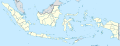 Map of Indonesia
- Article(s)
- Regions of Indonesia, Great East
- Request
- Could you guys create a map of Eastern Indonesia, like this or this. In Wikipedia Indonesia, there's already this one, but it's in poor quality and not available in Commons. Thanks in advance -- Bluesatellite (talk) 10:22, 21 November 2018 (UTC)
- Graphist opinion(s)
Plastic bag legislation - better map
-
 Plastic bag legislation worldwide

- Article(s)
- Phase-out of lightweight plastic bags
- Request
- This map illustrates the different plastic bag legislation worldwide. I'm wondering if it would be possible to display the same information in a better quality world map with the same borders (essentially, world map with country borders plus the state/provincial borders of USA, Canada and Australia). I'd be happy to colour in the map if someone could provide me with an svg of the blank map. Thanks -- Del♉sion23 (talk) 12:00, 23 December 2018 (UTC)
- Discussion
I've found a resonable blank map, albeit without the states and provinces. This will be fine and I suppose treats subnational units in a more consistent way. Del♉sion23 (talk) 10:21, 28 December 2018 (UTC) {{resolved}}