The map contains a pretty major flaw. The Balto-Slavic family is shown with different colors, as the Baltic and Slavic languages are not "one" language today. The Indo-Iranian branch, which, similar to the Balto-Slavic family, also contains several independent branches (i.e. three), is wrongly represented on the map as if it was "one" language. I'm therefore looking for someone who could split the dark blue "area" into an Iranian, Indo-Aryan and Nuristani area.
Perhaps light blue, dark blue, and another blue-mix colour could do the trick. For comparison; the Baltic languages are shown in light green, whereas the Slavic langauges are shown in dark green. -- LouisAragon (talk) 18:34, 10 March 2018 (UTC)
@Maproom: Thanks for raising that up. Yes, it seems that the same thing is going on for the Romance languages. I agree that the map doesn't make the specific "claim", but often, things aren't needed to be explained "explicitly" for people to erroneously assume things. To the common user, who just often look at colours/patterns, I believe it may definitely appear as such. I think splitting all branches up would definitely raise the overal EV of the map. - LouisAragon (talk) 19:18, 10 March 2018 (UTC)
The map does not claim that each colour contains only one language. Spanish, French, Romanian and other languages are all shown in the same colour. Maproom (talk) 19:00, 10 March 2018 (UTC)
Indo-European family tree in order of first attestationIt seems the problem is the inconsistency. Every other group corresponds only to a level 1 division of the Indo-European language tree, whereas Balto-Slavic is further divided into level 2 divisions. At least according to the article (see tree to the right). The solution is either to subdivide all the other groups to level 2, or combine the Balto-Slavic groups into one. Auguel (talk) 23:20, 10 March 2018 (UTC)
Request
Hoping to improve the above article through a visual, and a map of county boundaries would be helpful. Data is available at the provincial government website(catalogue.data.gov.bc.ca) and hopefully it is easy to transpose. Much obliged.
Shoman93 (talk) 16:31, 8 April 2018 (UTC)
Put Wolnos on an orthographic projection centered on the specified oblasts in the pictures. EmuLover (talk) 15:58, 21 March 2018 (UTC)
Graphist opinion(s)
At the top of the article, it states that Anyone can make a request for a map to be created or improved for a Wikipedia article. Under this, making maps for NationStates is outside the goals of this project. User:Axisixa[t][c] 04:34, 9 April 2018 (UTC)
3) Given that the city of Durban, South Africa, is no longer scheduled to host the 2022 Games, the marker for the city should be removed from the map, and South Africa itself changed from purple back to red, as it no longer qualifies as a country that has hosted or plans to host the Games (after all, Montreal and Cardiff were scheduled to host the cancelled 1942 and 1946 Games respectively, and yet neither are marked as such, hence Durban shouldn't be either).
please make straightened, borderless png or svg… -- Kintetsubuffalo (talk) 11:42, 13 May 2018 (UTC)
Graphist opinion(s)
I could easily convert it to a png. But I don't know what you mean by "straightened" or "borderless". Do you want the borders of the states removed? Maproom (talk) 20:44, 13 May 2018 (UTC)
Sorry for being unclear, and thanks for getting this! This version is a scan, so it's not 100% straight-on every monitor I've checked it's a little off. If it was frameless (no outer rectangle, just the map and the names), the skew would not be noticeable.--Kintetsubuffalo (talk) 00:35, 14 May 2018 (UTC)
I can straighten it (I hadn't noticed the slight angle), and correct the spelling. But I'm reluctant to remove the border, as that would leave the longitude and latitude markers hanging, which might look odd. Maproom (talk) 08:37, 15 May 2018 (UTC)
Done I've straightened the borders, cropped off the marginal text, corrected the spelling of Hatohobel, and converted to .PNG. Maproom (talk) 15:26, 15 May 2018 (UTC)
Fantastic! Thank you Maproom! One last question before I close this. The German Palau article has a clickable map, can we do anything like that? If so I will make a separate request.--Kintetsubuffalo (talk) 05:30, 18 May 2018 (UTC)
en:WP supports clickable maps, and there are people here (en:WP, not necessarily this workshop) who can create them, but I'm not one of them. Maproom (talk) 07:08, 18 May 2018 (UTC)
The city of Dnipropetrovsk (Дніпропетровськ in the map) changed its name to Dnipro (Дніпро) in 2016. This needs to be reflected in the map. -- Dreigorich (talk) 23:53, 25 April 2018 (UTC)
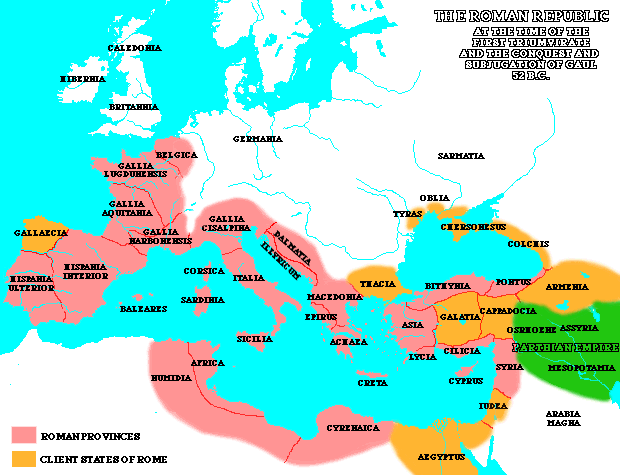
I would kindly ask any interested cartographer here to please create a suitable and well-sourced map for the Ptolemaic Kingdom as it existed during the latter half of the 1st century BC, particularly during the reign of Cleopatra VII or, if that cannot be achieved, at least one during the reign of her father Ptolemy XII. This is a Featured Article Candidacy review suggestion (no reliably-sourced map exists on Wikimedia Commons). The reviewer, User:Cplakidas, advised use of the following source for that endeavor: Historischer Atlas der antiken Welt (also here, published 2012). Alternatively, you could use an English language source, Stanley M. Burstein's Reign of Cleopatra (2004), which contains two maps between pp. 70–71 (one of Ptolemaic Egypt under Cleopatra, another of the Mediterranean world that includes both the Roman Republic and Ptolemaic Egypt, a scan of it seen here on Pinterest). Regards, Pericles of AthensTalk 01:15, 24 April 2018 (UTC)
Sorry to inundate you with options, but just one more possible source, perhaps with better context than these other images, is this one from a University of Oregon web page showing the Roman Republic and Ptolemaic Egypt in 52 BC. Pericles of AthensTalk 16:50, 27 April 2018 (UTC)
Again, I hate to do this, but here is yet another option to consider from Mount Holyoke College web page. It shows Ptolemaic Egypt and the Roman Republic from 44 to 31 BC, including the areas controlled by Octavian, Mark Antony, and Lepidus with the peace treaty of Brundisium in 40 BC. Pericles of AthensTalk 17:00, 27 April 2018 (UTC)
Need to update the 14 zonal former map of Nepal, which is now not valid as Nepal owned federalism in 2015, so need to update the old map with new 7 provincial map.
I would like to ask somebody to do a favor to create a district locator map (pg.29) and PBT maps (pg.30) for that 12 districts by refering this[1] angys (Talk Talk) 15:54, 28 April 2018 (UTC)

 Present-day native distribution of Indo-European languages, within their homeland of Eurasia.


 Ukrainian election map, 2019
 Done Maproom (talk) 16:55, 26 April 2018 (UTC)
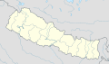 Former Map of Nepal with 14 Zonal division
 new map of federal Nepal with 7 Provinces
