Wikipedia:Graphics Lab/Map workshop/Archive/Aug 2018
| This is an archive of past discussions for the period 2018. Do not edit the contents of this page. If you wish to start a new discussion or revive an old one, please do so on the current main page. |

IndonesiaRegenciesMap.svg
- Article(s)
Indonesia and related
- Request
-
 Like this
 -
 base
base -
 sample


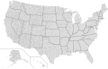
I feel like having IndonesiaRegenciesMap.svg like the US counties would come in handy in a lot of articles. The base provinces map is there, and there are images for the internal boundaries of most provinces here. Juxlos (talk) 23:39, 20 July 2018 (UTC)
And also, a slightly dated GeoJSON from 2014 here licensed under CC-BY-SA 4.0. The only alteration would be thickening some lines between East Kalimantan and North Kalimantan. Juxlos (talk) 02:22, 1 August 2018 (UTC)
- Graphist opinion(s)
Ukraine left the Commonwealth of Independent States.
- Article(s)
- Commonwealth of Independent States and related articles.
- Request
- Ukraine left the CIS 19 May 2018, effective 19 May 2019 over tensions with Russia. These maps (and possibly others) need to be updated. -- Dreigorich (talk) 17:42, 1 August 2018 (UTC)
- Graphist opinion(s)
Maps of Biafra

.png)
- Article(s)
- Any articles these maps already feature on
- Request
- Okay, would it be possible for someone to modify the above maps of the short-lived Republic of Biafra (1967-1970) in order to bring the borders of the world into line with what they were at the time, such as:
1) Removing the borders between the components of the then-Soviet Union.
2) Removing the borders between the components of what was then Yugoslavia.
2) Removing the border between the Czech Republic and Slovakia (then part of Czechoslovakia).
4) Removing the border between Eritrea and Ethiopia, as the former was part of the latter at the time.
5) Instating the border between the then separate countries of West Germany and East Germany.
Thanks. Snow Lion Fenian (talk) 08:03, 29 August 2018 (UTC)
- Graphist opinion(s)