Wikipedia:Graphics Lab/Map workshop/Archive/Jan 2021
| This page is an archive. Do not edit the contents of this page. Please direct any additional comments to the current main page. |

Queen Emma of Hawaii's 1865–66 travels to Europe and the United States
-
 Examples
 -
 Examples


- Article(s)
- Talk:Queen Emma of Hawaii#1865-66 Travel to Europe and the United States
- Request
- Please use the information gathered at Talk:Queen Emma of Hawaii#1865-66 Travel to Europe and the United States to create a map of the travels and stops of Queen Emma of Hawaii. Something like File:Kalakaua journey around the world.svg and File:Kalakaua's 1874-75 state visit map.svg. Really significant because she did this journey before the completion of the transcontinental railroad or the Panama Canal. -- KAVEBEAR (talk) 08:37, 25 December 2020 (UTC)
- Also a side note. If there is a possibility of including another color line for the travels of her other companions (see Talk:Kiliwehi#New Zealand).KAVEBEAR (talk) 09:12, 25 December 2020 (UTC)
Points in Queen Emma's journey for now. Will probably add more for her travels within Britain like to Colchester and Cornwall. KAVEBEAR (talk) 07:59, 30 December 2020 (UTC)
- Honolulu
- Acapulco, Mexico
- Panama City
- Colón, Panama
- Kingston, Jamaica
- Saint Thomas
- Southampton
- London
- Windsor Castle
- London
- Folkestone
- Boulogne
- Paris
- Macon
- Lyon
- Marseilles
- Hyeres
- Nice
- Menton
- Cogoleto
- Genoa
- Bolgona
- Pracchia
- Florence
- Venice
- Milan
- Geneva
- Karlsruhe
- Paris
- London
- Stratford-on-Avon
- Birmingham
- Port of Holyhead
- Dún Laoghaire (Kingstown)
- Dublin
- Killarney
- Cork
- Cobh (Queenstown)
- New York City
- Washington, DC
- Baltimore
- Sunbury, PA
- Cataract House, Niagara Falls
- Clifton Hotel, Niagara Falls
- Montreal
- Quebec
- New York
- Colón, Panama
- Panama City
- San Francisco
- Honolulu
- Discussion
Map translation request

- Article(s)
- Maximilian von Spee, SMS Dresden (1907), SMS Gneisenau, SMS Scharnhorst
- Request
- Can we get a version translated into English? There are German, Spanish, French, and Norwegian versions of the file but we could use one in English as well. Thanks in advance. Parsecboy (talk) 21:47, 29 December 2020 (UTC)
- Discussion
 Done by using
 <switch>...</switch>. Someone already put an hu-language one there, so I just added an English one and did a small hack to make MediaWiki detect it. --Artoria2e5 🌉 19:03, 1 January 2021 (UTC)
Cadastral municipalities of Croatia

- Article(s)
- Cadastral community
- Request
- Hello, can you please make a map of Croatia divided into cadastral municipalities? The map above shows the division of Croatia into municipalities, but they are not the same as cadastral municipalities. If you need any more information of help, let me know. Thanks in advance. -- Kaštel Stari (talk) 12:22, 29 November 2020 (UTC)
- Discussion
Hi Kaštel Stari, I can give a try if I can find referenced data for the cadastral municipalities in Croatia. Do you have any idea if such data can be found? --Ikonact (talk) 20:31, 7 December 2020 (UTC)
- Hello Ikonact, it would be great if you could do that. Here on this link https://www.katastar.hr/en/#/ you will get an official map of Croatia divided into cadastral municipalities, so it will be of great help to you. To see a map of cadastral municipalities click Find cadastral parcel and then zoom in. Kaštel Stari (talk) 20:56, 7 December 2020 (UTC)
- Thanks Kaštel Stari! I looked at the site and it is quite helpful. Unfortunately, I do not see a way to download the borders of the municipalities in digital format. I will need digital data otherwise it will be quite a difficult task to draw by hand all municipalities --Ikonact (talk) 08:34, 8 December 2020 (UTC)
- Ok, I found another site https://geoportal.nipp.hr/en/ or https://geoportal.nipp.hr/geonetwork/srv/eng/catalog.search#/metadata/d1c956e1-437c-42d8-b1bc-fa9953269ce2. I hope this will be more helpful. Kaštel Stari (talk) 08:54, 8 December 2020 (UTC)
- Thanks Kaštel Stari! I looked quickly on the links and this may work. I was not able to find out quickly how to download the data but I will dig later on and keep you informed. --Ikonact (talk) 09:31, 8 December 2020 (UTC)
- Ok, great!!! Kaštel Stari (talk) 09:41, 8 December 2020 (UTC)
- Kaštel Stari on a first try I can get the cadaster data but I cannot extract usable digital data. The site provides WMS services which is in fact images not a vector data. I will try again but the best will be to get hold of the cadaster municipality vector data. --Ikonact (talk) 22:03, 8 December 2020 (UTC)
- Ok Ikonact, I can't find cadaster municipality vector data so I can't help you no more. Kaštel Stari (talk) 22:11, 8 December 2020 (UTC)
- Kaštel Stari I am sorry. I will continue checking what I can do but ideally I can do a map from vector data. Otherwise it is complicated for me to draw by hand. I guess this data should be available somewhere as the legislation in EU request open access to such data. Still not giving up :) --Ikonact (talk) 22:20, 8 December 2020 (UTC)
- Ok Ikonact, if you cant' find vector data, can you at least make part of the map? And I was looking but I can't find anything online. Thanks Kaštel Stari (talk) 22:33, 8 December 2020 (UTC)
- Kaštel Stari I am sorry. I will continue checking what I can do but ideally I can do a map from vector data. Otherwise it is complicated for me to draw by hand. I guess this data should be available somewhere as the legislation in EU request open access to such data. Still not giving up :) --Ikonact (talk) 22:20, 8 December 2020 (UTC)
- Ok Ikonact, I can't find cadaster municipality vector data so I can't help you no more. Kaštel Stari (talk) 22:11, 8 December 2020 (UTC)
- Kaštel Stari on a first try I can get the cadaster data but I cannot extract usable digital data. The site provides WMS services which is in fact images not a vector data. I will try again but the best will be to get hold of the cadaster municipality vector data. --Ikonact (talk) 22:03, 8 December 2020 (UTC)
Hi Kaštel Stari! I looked for vector data but I cannot find. I think we can write to the contact person on this page and ask if vector data is available. I guess you speak Croatian so you can send a mail. Otherwise I can send it in English. Please let me know --Ikonact (talk) 08:22, 9 December 2020 (UTC)
- Hi Ikonact! I think it's better that you ask then me, and just put It that you need vector data for all cadastral municipalities not any specific cadastral parcel and if they reject you, I don't even need the whole of Croatia but a smaller part of it. Send an email and we'll see. Thanks Kaštel Stari (talk) 08:34, 9 December 2020 (UTC)
- Kaštel Stari, I sent the mail today. I will let you know when I have an answer. Cheers --Ikonact (talk) 10:31, 9 December 2020 (UTC)
- Ikonact, great. Thanks! Kaštel Stari (talk) 10:45, 9 December 2020 (UTC)
- Kaštel Stari I have no answer. In the meantime I see that a WFS was added that can help to download vector data but I cannot manage to make it work. Every time I try to connect it gives an error and requires authentication. I will keep trying. --Ikonact (talk) 21:37, 19 December 2020 (UTC)
- Ikonact, great. Thanks! Kaštel Stari (talk) 10:45, 9 December 2020 (UTC)
- Kaštel Stari, I sent the mail today. I will let you know when I have an answer. Cheers --Ikonact (talk) 10:31, 9 December 2020 (UTC)
This request is solved, I've uploaded the map here: [1] Tezwoo (talk) 23:01, 1 January 2021 (UTC)
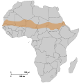
Great Green Wall Map
-
 blank map

- Article(s)
- Great Green Wall
- Request
- Please make a map highlighting the participating countries and the route of the GGW using the blank map above (keep the sahel area). DSMR.pdf page 2 contains the route. Feel free to crop the image to a more horizontal shape, similar to the existing sahara image or the lemonde.fr pic. -- Artoria2e5 🌉 18:47, 1 January 2021 (UTC)
- Discussion

Something like that? --Sevgart (talk) 12:15, 6 January 2021 (UTC)
Request: Infobox map of Saxony
- Article(s)
- Saxony
- Request
- The map in the infobox on this page seems to be broken (see comments on Talk page): it is simply a map of Germany, showing state boundaries, but without naming or highlighting Saxony. Can somebody fix, please? Thanks. GrindtXX (talk) 00:37, 10 January 2021 (UTC)
- Discussion
It is highlighting Saxony when I look at it. If you can highlight particular issues the best place may be Module talk:Mapframe. CMD (talk) 02:53, 10 January 2021 (UTC)
Cuba is redesignated as state sponsor of terrorism
-
 map
map

- Article(s)
- State Sponsors of Terrorism (U.S. list)
- Request
- Cuba was just re-added to the list, source is in the article -- Fixmaster (talk) 02:04, 12 January 2021 (UTC)
- Discussion
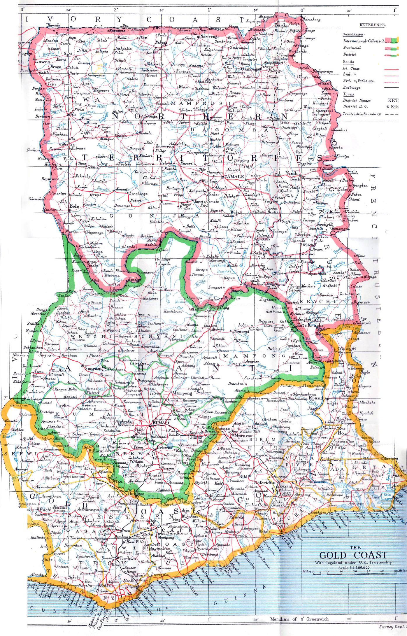
Request for historical map of Ghana
-
 Instead of today′s regions, the borders of the pre-independence regional configurations should be shown, perhaps also (with less line thickness?) the borders of the five regions post-independence.

![[1]](https://commons.wikimedia.org/wiki/File:Cadastral_municipalities_of_Croatia.svg)
- Article(s)
- Regions of Ghana etc
- Request
- To show what Ghana looked like just before independence, it would be nice to have a map of the pre-independence regional configurations (Northern Territories, Ashanti, Gold Coast Colony′s Western and Eastern Province, Trans-Volta Togoland). This map (1946) could serve as a model. Trans-Volta Togoland ("Trusteeship boundary" in first map), however, should be demarcated as in this map. Thanks a lot! --Jakob Gottfried (talk) 11:50, 9 January 2021 (UTC)
- Discussion
 Request taken by Amitchell125 (talk) 08:52, 26 January 2021 (UTC).
- @Jakob Gottfried: Done, see your talk page. Regards, Amitchell125 (talk) 14:22, 26 January 2021 (UTC)
- @Jakob Gottfried: Adjustments made (including the removal of the reservoir, dated 1961–1965). Amitchell125 (talk) 09:53, 27 January 2021 (UTC)
- @Jakob Gottfried:
Unlimited age of consent by country
| Unlimited age of consent by country | ||||||
|---|---|---|---|---|---|---|
| Male | Female | |||||
| Heterosexual |
|
| ||||
| Homosexual |
|
| ||||
| 9 10 11 12 13 14 15 16 17 18 19 20 21 Illegal at any age Unknown Varies by state | ||||||
- Article(s)
- List of countries by age of consent
- Request
- Can someone please update this map? Firstly, the age for Japan is currently wrong, as according to what is listed on the table on the page, the age for unlimted hetrosexual consent in Japan is 18, not 20, and therefore should be green, not blue. Can someone also please include the relevant colours for Australia? Per the table on the page each of Australia's eight states has an age of either 16 or 17 respectively. Helper201 (talk) 22:30, 18 December 2020 (UTC)
- Discussion
I've managed to correct the colour for Japan myself but I could still do with some help adding the correct colours for Australia please as I am unaware of how to do this. Helper201 (talk) 19:35, 19 December 2020 (UTC)