Wikipedia:Graphics Lab/Map workshop/Archive/Dec 2020
| This page is an archive. Do not edit the contents of this page. Please direct any additional comments to the current main page. |

Request for Correction in Maps of India
-
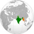 Correct Map showing locations of India and Myanmar
 -
 India - Bhutan
 Done by User:RexxS, thanks!
 -
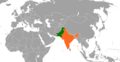 Incorrect Map showing locations of India and Pakistan


- Article(s)
- Bhutan–India relations, India–Pakistan relations
- Request
- Details of your request go here… As it can be seen, disputed territories of Kashmir are correctly shown in the first map, but, not so in other two maps. Hence, it is requested that corrected maps be created. Also, relevant discussion on related article's talk pages:
- 1. India-Bhutan
- 2. India-Pakistan
Dhawangupta (talk) 09:10, 3 December 2020 (UTC)
- Discussion
The Boat Race 2021 course
- Article(s)
- The Boat Race 2021
- Request
- Unusual times, but this year the Boat Race is being held on the River Great Ouse as opposed to the Thames, and I'd like a map to reflect the course. The official website has a crude course map and I've found the two (appropriately licensed) Ordnance Survey maps which cover it (TL58SE and TL58NE). I guess ideally the two images need to be tiled and then the result cropped down, and finally the course overlaid on top per the official website. Cheers. The Rambling Man (Stay alert! Control the virus! Save lives!!!!) 15:27, 14 January 2021 (UTC)
- Discussion
-
- Hi, @The Rambling Man:, happy to sort this one out.
 Request taken by Amitchell125 (talk) 17:50, 25 January 2021 (UTC).
- Amitchell125 Yay, that's brilliant news. Thanks, let me know if you need any more information? Cheers. The Rambling Man (Stay alert! Control the virus! Save lives!!!!) 17:52, 25 January 2021 (UTC)
- @The Rambling Man: The map I've produced can be found here. Please let me know of any amendments you think need to be made, as almost anything can be altered. Done Amitchell125 (talk) 21:06, 25 January 2021 (UTC)
- Amitchell125 that's just spot on, thanks for your help and thanks for getting it done so quickly, very much appreciated! The Rambling Man (Stay alert! Control the virus! Save lives!!!!) 21:08, 25 January 2021 (UTC)
- @The Rambling Man: Cheers! Amitchell125 (talk) 21:10, 25 January 2021 (UTC)
- {{Resolved}}
- @The Rambling Man: Cheers! Amitchell125 (talk) 21:10, 25 January 2021 (UTC)
- Amitchell125 that's just spot on, thanks for your help and thanks for getting it done so quickly, very much appreciated! The Rambling Man (Stay alert! Control the virus! Save lives!!!!) 21:08, 25 January 2021 (UTC)
- @The Rambling Man: The map I've produced can be found here. Please let me know of any amendments you think need to be made, as almost anything can be altered.
- Amitchell125 Yay, that's brilliant news. Thanks, let me know if you need any more information? Cheers. The Rambling Man (Stay alert! Control the virus! Save lives!!!!) 17:52, 25 January 2021 (UTC)
- Hi, @The Rambling Man:, happy to sort this one out.
Coloring adjustment for map, per FAC recommendation
-
 Map of different stages of the early Muslim conquests, centered on northern Iran for emphasis on that region.
.jpg)
- Article(s)
- Sulayman ibn Abd al-Malik
- Request
- In the course of the current FAC of Sulayman ibn Abd al-Malik, it was suggested in the Image Review that the difference between the green vs lime green-shaded areas of the map be improved for clarity, and further, I think the difference between the dark brown and light brown should also be improved. Perhaps its best that the lime green and light brown be replaced with entirely different colors: lime green → orange, light brown → purple. I am not able to do this without botching the map. Any help is appreciated. Thank you. -- Al Ameer (talk) 04:58, 18 January 2021 (UTC)
- Discussion
Hi @Al Ameer son: - As far as I know your request can't easily be done without making a new map. I can help you, but I'll look first to see how big the task is before committing. Regards, Amitchell125 (talk) 19:02, 24 January 2021 (UTC)
- Thank you for considering this request Amitchell125 and yes, please let me know. I personally think it may be too much trouble. If you confirm, I’ll move to the alternative of using File:Northern Iran and its surroundings during the Iranian intermezzo.svg. Al Ameer (talk) 02:40, 25 January 2021 (UTC)
- No, had a look and it's not too much trouble, I'll get started on it. Amitchell125 (talk) 09:04, 25 January 2021 (UTC)
- @Al Ameer son: All done (here) - let me know of anything that needs to be amended. Regards - and good luck with the article. Done Amitchell125 (talk) 21:34, 25 January 2021 (UTC)
- @Amitchell125: Replied at my talk page. Thanks again for your efforts here. Regards --Al Ameer (talk) 22:20, 25 January 2021 (UTC)
- {{Resolved}}
- @Amitchell125: Replied at my talk page. Thanks again for your efforts here. Regards --Al Ameer (talk) 22:20, 25 January 2021 (UTC)
- @Al Ameer son: All done (here) - let me know of anything that needs to be amended. Regards - and good luck with the article.
- No, had a look and it's not too much trouble, I'll get started on it. Amitchell125 (talk) 09:04, 25 January 2021 (UTC)
Independence from Britain
-
-
 Actual flag of Dominica
 -
 Current flag of Belize
 -
 Pacific islands map


- Article(s)
- List of countries that have gained independence from the United Kingdom
- Request
- Okay, I've noticed a few inaccuracies with the above-left map that should probably be fixed:
1) The flag of the Dominican Republic is incorrectly shown for Dominica (above), a completely different country.
2) Saint Vincent and the Grenadines gained independence in 1979, not 1931.
3) There's no arrows linking the flags of the Maldives, Myanmar and Sudan to their respective countries.
4) The flag of Malta is wrongly shown to be linked to the Balearic Islands, not at Malta itself.
5) Nauru gained independence in 1968, not 1957.
6) The Maldives gained independence in 1965, not 1982.
7) The flags of Tonga and Tuvalu are actually shown pointing to Fiji, and the flag of Fiji itself is linked to Vanuatu (the actual locations of said countries are provided on the above-right map).
8) The flag of Qatar is wrongly shown to be linked to the United Arab Emirates, not at Qatar itself.
9) The flag of Jordan seems to be pointing more at the West Bank than at Jordan itself.
10) The flag of Belize was slightly altered in 2019 (as shown above), so the one on the map should be changed to reflect that.
11) The flag of Mauritius is not pointing at Mauritius at all, but rather at a random spot in the Indian Ocean.
12) Papua New Guinea gained independence from Australia in 1975, not from Britain, hence it should be removed from the map (otherwise the map would have to include all other countries that gained independence from former British holdings, such as Samoa, Bangladesh, Namibia, South Sudan, etc.).
Thanks. Snow Lion Fenian (talk) 16:16, 13 December 2020 (UTC)
- Discussion
Wind patterns in Adriatic Sea
-
 Wind patterns in Adriatic Sea

- Article(s)
- Adriatic Sea
- Request
- Hello, can you make this map in SVG format? Thanks Kaštel Stari (talk) 18:03, 13 December 2020 (UTC)
- Discussion
Morocco-Algeria border 1963

- Article(s)
- Sand War
- Request
- The issue here is awful kerning, such that some letters are on top of each other. (An English version of the map would also be helpful. I would be happy to provide translations; ping me if you want them.) —Μετάknowledgediscuss/deeds 06:36, 18 December 2020 (UTC)
- Discussion
World Laws on Shark Fishing

- Article(s)
- Animal rights by country or territory, Shark finning
- Request
As of November 26, 2020, Colombia bans the commercial and subsistence fishing of sharks within its waters. The map should now reflect this change and, according to the map legend, should now be colored in red rather than black. References are all currently in Spanish as it's breaking news.[1][2] --anfecaro (talk) 15:58, 25 November 2020 (UTC)
- Discussion
SVG version of File:Battle of the Falkland Islands (1914) Map.png
-
 Map showing the movements of British and German ships during the Battle of the Falkland Islands
_Map.png)
- Article(s)
- SMS Gneisenau, SMS Dresden (1907), SMS Nürnberg (1906)
- Request
- I'd like to get an SVG version of the map made that's easier to read; ideally something along the lines of File:Battle of Coronel map.svg, which is much easier to differentiate the two sides, read the names of ships, etc. FWIW, one of the above articles is an FA, and another (SMS Gneisenau) is currently at FAC. Thanks in advance. Parsecboy (talk) 14:24, 10 December 2020 (UTC)
- Discussion
![]() Request taken by Amitchell125 (talk) 20:42, 8 January 2021 (UTC). —this shouldn't be a problem. AM
Request taken by Amitchell125 (talk) 20:42, 8 January 2021 (UTC). —this shouldn't be a problem. AM
- First draft done - see your talk page. Amitchell125 (talk) 18:56, 24 January 2021 (UTC)
- {{resolved}}
- First draft done - see your talk page. Amitchell125 (talk) 18:56, 24 January 2021 (UTC)
Poll tax as a condition to voting in the US
-
 Poll tax history

- Article(s)
- Women's poll tax repeal movement
- Request
- This article is is currently at FAC. One of the reviewers found the above map, but I'd like to tailor it to specifically address only poll taxes which applied as prerequisites to voting in the US. A discussion, along with sourcing is here: Talk:Women's poll tax repeal movement#GIF
- Can the title be "Poll tax as a condition to voting"? (Or possibly History of ... )
- Can we add and remove parts of the GIF as indicated in the discussion?
- Can we change the colors as indicated in the discussion?
- Can you slow down the time increment so that people have the opportunity to read the text? Thanks! -- SusunW (talk) 19:12, 18 December 2020 (UTC)
- Discussion
Susun, not sure if you're requesting a new GIF or to modify the old, but I think a new one is the right way to go -- the existing one can be used where it is now. Mike Christie (talk - contribs - library) 15:00, 19 December 2020 (UTC)
- I assumed that the original would stay as it is and the changes we are asking for would be a derivative but separate image. The idea wasn't ours, it was the original creator's, but we want a new GIF based on that concept. SusunW (talk) 15:28, 19 December 2020 (UTC)
Home-based worker percentage 2019
-
 Blankmap-world v6

_Map.png)
_Map.png)
_Map.png)
- Article(s)
- Telecommuting
- Request
- Refer to Working from home: estimating the worldwide potential, Figure 1
Just color blankmap world v6 using the color scheme used there (or to improve the map further you can use different colors, like red (=less then 5%), orange (5-10%), yellow (10-15%), green (15+%)) Title of the new file should be "Home-based_worker_percentage_2019" --Genetics4good (talk) 12:55, 20 December 2020 (EST)
- Discussion
- Request taken by Amitchell125 (talk) 07:48, 3 February 2021 (UTC).
- Hi @Genetics4good: Please find the first draft of the map here. Please could you check it for me, as the colours in the original map were sometimes difficult to see properly? The yellow is to make it clear which states had not been filled in, this colour (and any of the others) can be amended as you wish. Regards, Amitchell125 (talk) 09:43, 3 February 2021 (UTC)
- @Amitchell125: Looks fine, but change the color scheme to the one I proposed. No data can be left grey.
- Hi @Genetics4good: Please find the first draft of the map here. Please could you check it for me, as the colours in the original map were sometimes difficult to see properly? The yellow is to make it clear which states had not been filled in, this colour (and any of the others) can be amended as you wish. Regards, Amitchell125 (talk) 09:43, 3 February 2021 (UTC)
--Genetics4good (talk) 11:07, 3 February 2021 (UTC)
- @Genetics4good: - colours amended. Amitchell125 (talk) 15:28, 3 February 2021 (UTC)
- Superb. Placed it at telecommuting page
- @Genetics4good: - colours amended. Amitchell125 (talk) 15:28, 3 February 2021 (UTC)
--Genetics4good (talk) 16:35, 3 February 2021 (UTC)
- {{resolved}}
EGDI-levels by country 2020
-
Blankmap-world v6
- Article(s)
- E-government#UN_e-Government_Development_Index
- Request
- Refer to E-government survey 2020, Figure 1.1 at chapter 1 page 41 entitled "Geographraphical distribution of the 4 egdi groups"
Just color blankmap world v6 using the color scheme used there (or to improve the map further you can use different colors, like red (=low), orange (middle), yellow (high), very high (green)) Title of the new file should be "EGDI-levels by country 2020" --Genetics4good (talk) 19:55, 26 November 2020 (EST)
Perhaps an even better approach is to just go to 2020 E-Government Development Index country listings, print screen, paste in GIMP, open Blankmap-world-v6 and simply detect the image color of each country (there's a GIMP tool for that) and then color the countries of Blankmap-world-v6 (both images can be put side by side, allowing to do this very quickly)
- Discussion
-
- Request taken by Amitchell125 (talk) 15:36, 3 February 2021 (UTC).
- @Genetics4good: - Done here (please let me know of any amendments you would like}. Regards, Amitchell125 (talk) 17:02, 3 February 2021 (UTC)
- {{resolved}}
- @Genetics4good: -
Ambuliyar River
- Article(s)
- Ambuliyar River
- Request
- Sorry in advance if this is difficult. An overlay showing just the outline of the drainage basin, and paths of the river and tributaries, in the style of something like this for a river in Tamil Nadu, using this Tamil Nadu map as a base, and the map from the second page of this pdf as the main source for the outline of the basin and the course of the 4 constituent rivers of the system. One other reference that I hope is helpful is this other, simpler map of the basin. For actually putting the overlay onto the right spot on the larger map, hopefully the map from page 3 of this pdf helps, also the basin is right to the east of this basin outline. Thanks for any potential help with this. Starkenborgher (talk) 22:04, 2 February 2021 (UTC)
- Discussion
![]() Request taken by Amitchell125 (talk) 08:09, 4 February 2021 (UTC).
Request taken by Amitchell125 (talk) 08:09, 4 February 2021 (UTC).
- @Amitchell125, I realized after writing the request that putting the watershed onto the overlay would mean there wouldn't be that much detail on the watershed itself. Would it be possible to essentially make a map within a map, in which one would be the overlay onto Tamil Nadu, while one would be just the watershed, and have it show how the map kind of "zooms in," sort of like how the zoom in on the city of Amsterdam is done here? If its not possible or is too much I totally understand. Thanks for all your help.
- Hi @Starkenborgher: please find my first draft of your requested map here. Let me know if you want to amend anything, it's not too difficult to correct errors, alter the colours, etc. Done Regards, Amitchell125 (talk) 22:52, 5 February 2021 (UTC)
- Hi @Amitchell125:, phenomenal stuff, better than I could have imagined, thanks so much. One minor thing, forgot to ask for river name inclusion. The bottom left river is the Maruthankudiyar River, and the tributary it has that flows sort of southeast into it is the Vellunniyar River. The river that begins in the northwest is the Ambuliyar River, which continues in the bottom right after all the tributaries join and as it goes to the sea. The northeastern river, that flows south into the Ambuliyar, is the Punakkuttiyar River. If you could add these names adjacent to the rivers, that would be great. OH AAA can you also change Bay of Bengal to Palk Strait. Starkenborgher (talk) 00:42, 6 February 2021 (UTC)
- @Starkenborgher: Changes made, let me know if anything needs to be amended. Amitchell125 (talk) 10:13, 6 February 2021 (UTC)
- Thanks for your help.Starkenborgher (talk) 17:38, 6 February 2021 (UTC)
- @Starkenborgher: Changes made, let me know if anything needs to be amended. Amitchell125 (talk) 10:13, 6 February 2021 (UTC)
- Hi @Amitchell125:, phenomenal stuff, better than I could have imagined, thanks so much. One minor thing, forgot to ask for river name inclusion. The bottom left river is the Maruthankudiyar River, and the tributary it has that flows sort of southeast into it is the Vellunniyar River. The river that begins in the northwest is the Ambuliyar River, which continues in the bottom right after all the tributaries join and as it goes to the sea. The northeastern river, that flows south into the Ambuliyar, is the Punakkuttiyar River. If you could add these names adjacent to the rivers, that would be great. OH AAA can you also change Bay of Bengal to Palk Strait. Starkenborgher (talk) 00:42, 6 February 2021 (UTC)
- Hi @Starkenborgher: please find my first draft of your requested map here. Let me know if you want to amend anything, it's not too difficult to correct errors, alter the colours, etc.
- @Amitchell125, I realized after writing the request that putting the watershed onto the overlay would mean there wouldn't be that much detail on the watershed itself. Would it be possible to essentially make a map within a map, in which one would be the overlay onto Tamil Nadu, while one would be just the watershed, and have it show how the map kind of "zooms in," sort of like how the zoom in on the city of Amsterdam is done here? If its not possible or is too much I totally understand. Thanks for all your help.
{{resolved}}