The World Portal


The world is the totality of entities, the whole of reality, or everything that exists. The nature of the world has been conceptualized differently in different fields. Some conceptions see the world as unique, while others talk of a "plurality of worlds". Some treat the world as one simple object, while others analyze the world as a complex made up of parts.
In scientific cosmology, the world or universe is commonly defined as "[t]he totality of all space and time; all that is, has been, and will be". Theories of modality talk of possible worlds as complete and consistent ways how things could have been. Phenomenology, starting from the horizon of co-given objects present in the periphery of every experience, defines the world as the biggest horizon, or the "horizon of all horizons". In philosophy of mind, the world is contrasted with the mind as that which is represented by the mind.
Theology conceptualizes the world in relation to God, for example, as God's creation, as identical to God, or as the two being interdependent. In religions, there is a tendency to downgrade the material or sensory world in favor of a spiritual world to be sought through religious practice. A comprehensive representation of the world and our place in it, as is found in religions, is known as a worldview. Cosmogony is the field that studies the origin or creation of the world, while eschatology refers to the science or doctrine of the last things or of the end of the world.
In various contexts, the term "world" takes a more restricted meaning associated, for example, with the Earth and all life on it, with humanity as a whole, or with an international or intercontinental scope. In this sense, world history refers to the history of humanity as a whole, and world politics is the discipline of political science studying issues that transcend nations and continents. Other examples include terms such as "world religion", "world language", "world government", "world war", "world population", "world economy", or "world championship". (Full article...)
Selected articles -
-


A world map on the Winkel tripel projection,
a low-error map projection adopted by the National Geographic Society for reference maps
A world map is a map of most or all of the surface of Earth. World maps, because of their scale, must deal with the problem of projection. Maps rendered in two dimensions by necessity distort the display of the three-dimensional surface of the Earth. While this is true of any map, these distortions reach extremes in a world map. Many techniques have been developed to present world maps that address diverse technical and aesthetic goals.
Charting a world map requires global knowledge of the Earth, its oceans, and its continents. From prehistory through the Middle Ages, creating an accurate world map would have been impossible because less than half of Earth's coastlines and only a small fraction of its continental interiors were known to any culture. With exploration that began during the European Renaissance, knowledge of the Earth's surface accumulated rapidly, such that most of the world's coastlines had been mapped, at least roughly, by the mid-1700s and the continental interiors by the twentieth century. (Full article...) -
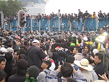
Protestors clash with Hong Kong police in the Wan Chai waterfront area during the WTO Ministerial Conference of 2005.
Since its creation in 1995, the World Trade Organization (WTO) has worked to maintain and develop international trade. As one of the largest international economic organizations (alongside the International Monetary Fund (IMF) and the World Bank), it has strong influence and control over trading rules and agreements, and thus has the ability to affect a country's economy immensely. The WTO policies aim to balance tariffs and other forms of economic protection with a trade liberalization policy, and to "ensure that trade flows as smoothly, predictably and freely as possible".
Indeed, the WTO claims that its actions "cut living costs and raise standards, stimulate economic growth and development, help countries develop, [and] give the weak a stronger voice." Statistically speaking, global trade has consistently grown between one and six percent per annum over the past decade, and US$38.8 billion were allocated to Aid for Trade in 2016.
Yet several criticisms of the WTO have arisen over time from a range of fields, including economists such as Dani Rodrik and Ha Joon Chang, and anthropologists such as Marc Edelman, who have argued that the institution "only serves the interests of multinational corporations, undermines local development, penalizes poor countries, [and] is increasing inequality", and have argued that some agreements about agriculture and pharmaceutical goods have led to restricted access to food and healthcare, thus causing large numbers of deaths. Several factors are alleged to contribute to these conditions, including but not limited to: the most favoured nation rule (MFN), national treatment policies, and failure to regard the infant industry argument. Critics argue that the policies that support these principles fail to protect developing nations, and in some cases take advantage of them. For example, UNCTAD estimates that market distortions cost developing countries $700 billion annually in lost export revenue. (Full article...) -

The League of Nations (LN or LoN; French: Société des Nations [sɔsjete de nɑsjɔ̃], SdN) was the first worldwide intergovernmental organisation whose principal mission was to maintain world peace. It was founded on 10 January 1920 by the Paris Peace Conference that ended the First World War. The main organization ceased operations on 18 April 1946 when many of its components were relocated into the new United Nations. As the template for modern global governance, the League profoundly shaped the modern world.
The League's primary goals were stated in its eponymous Covenant. They included preventing wars through collective security and disarmament and settling international disputes through negotiation and arbitration. Its other concerns included labour conditions, just treatment of native inhabitants, human and drug trafficking, the arms trade, global health, prisoners of war, and protection of minorities in Europe. The Covenant of the League of Nations was signed on 28 June 1919 as Part I of the Treaty of Versailles, and it became effective with the rest of the Treaty on 10 January 1920. Australia was granted the right to participate as an autonomous member nation, marking the start of Australian independence on the global stage. The first meeting of the Council of the League took place on 16 January 1920, and the first meeting of the Assembly of the League took place on 15 November 1920. In 1919, U.S. president Woodrow Wilson won the Nobel Peace Prize for his role as the leading architect of the League. (Full article...) -

The World Health Organization in Geneva, Switzerland
Global health is the health of populations in a worldwide context; it has been defined as "the area of study, research, and practice that places a priority on improving health and achieving equity in health for all people worldwide". Problems that transcend national borders or have a global political and economic impact are often emphasized. Thus, global health is about worldwide health improvement (including mental health), reduction of disparities, and protection against global threats that disregard national borders, including the most common causes of human death and years of life lost from a global perspective.
Global health is not to be confused with international health, which is defined as the branch of public health focusing on developing nations and foreign aid efforts by industrialized countries. (Full article...) -
Ozone depletion and climate change are environmental challenges whose connections have been explored and which have been compared and contrasted, for example in terms of global regulation, in various studies and books.
There is widespread scientific interest in better regulation of climate change, ozone depletion and air pollution, as in general the human relationship with the biosphere is deemed of major historiographical and political significance. Already by 1994 the legal debates about respective regulation regimes on climate change, ozone depletion and air pollution were being dubbed "monumental" and a combined synopsis provided. (Full article...) -

Ding Liren of China, the current world champion (2023)
The World Chess Championship is played to determine the world champion in chess. The current world champion is Ding Liren, who defeated his opponent Ian Nepomniachtchi in the 2023 World Chess Championship. Magnus Carlsen, the previous world champion, had declined to defend his title.
The first event recognized as a world championship was the 1886 match between the two leading players in the world, Wilhelm Steinitz and Johannes Zukertort. Steinitz won, becoming the first world champion. From 1886 to 1946, the champion set the terms, requiring any challenger to raise a sizable stake and defeat the champion in a match in order to become the new world champion. Following the death of reigning world champion Alexander Alekhine in 1946, FIDE (the International Chess Federation) took over administration of the World Championship, beginning with the 1948 World Championship tournament. From 1948 to 1993, FIDE organized a set of tournaments to choose a new challenger every three years. In 1993, reigning champion Garry Kasparov broke away from FIDE, which led to a rival claimant to the title of World Champion for the next thirteen years. The titles were unified at the World Chess Championship 2006, and all subsequent matches have once again been administered by FIDE. (Full article...) -

Atlantic Ocean near the Faroe Islands
A sea is a large body of salty water. There are particular seas and the sea. The sea commonly refers to the World Ocean, the wider body of seawater.
Particular seas are either marginal seas, second-order sections of the oceanic sea (e.g. the Mediterranean Sea), or certain large, nearly landlocked bodies of water.
The salinity of water bodies varies widely, being lower near the surface and the mouths of large rivers and higher in the depths of the ocean; however, the relative proportions of dissolved salts vary little across the oceans. The most abundant solid dissolved in seawater is sodium chloride. The water also contains salts of magnesium, calcium, potassium, and mercury, amongst many other elements, some in minute concentrations. A wide variety of organisms, including bacteria, protists, algae, plants, fungi, and animals live in the seas, which offers a wide range of marine habitats and ecosystems, ranging vertically from the sunlit surface and shoreline to the great depths and pressures of the cold, dark abyssal zone, and in latitude from the cold waters under polar ice caps to the warm waters of coral reefs in tropical regions. Many of the major groups of organisms evolved in the sea and life may have started there. (Full article...)


.svg)


General images -
-
 A composite image of Earth, with its different types of surface discernible: Earth's surface dominating Ocean (blue), Africa with lush (green) to dry (brown) land and Earth's polar ice in the form of Antarctic sea ice (grey) covering the Antarctic or Southern Ocean and the Antarctic ice sheet (white) covering Antarctica. (from Earth)
 -
 Empires of the world in 1898
 -
 An artist's rendering of a protoplanetary disk (from History of Earth)
 -
 First airplane, the Wright Flyer, flew on 17 December 1903.
 -
 13th-century French historiated initial with the three classes of medieval society: those who prayed (the clergy), those who fought (the knights), and those who worked (the peasantry) (from Human history)
 -
 Notre-Dame de Paris, France
 -

-
 Pillar erected by Ashoka, a Mauryan Emperor in India
 -
 An artist's impression of the Archean, the eon after Earth's formation, featuring round stromatolites, which are early oxygen-producing forms of life from billions of years ago. After the Late Heavy Bombardment, Earth's crust had cooled, its water-rich barren surface is marked by continents and volcanoes, with the Moon still orbiting Earth half as far as it is today, appearing 2.8 times larger and producing strong tides. (from Earth)
 -
 Tracy Caldwell Dyson, a NASA astronaut, observing Earth from the Cupola module at the International Space Station on 11 September 2010 (from Earth)
 -
 Dinosaurs were the dominant terrestrial vertebrates throughout most of the Mesozoic (from History of Earth)
 -
 A 580 million year old fossil of Spriggina floundensi, an animal from the Ediacaran period. Such life forms could have been ancestors to the many new forms that originated in the Cambrian Explosion. (from History of Earth)
 -
 A composite image of artificial light emissions at night on a map of Earth (from Earth)
 -
 Graph showing range of estimated partial pressure of atmospheric oxygen through geologic time (from History of Earth)
 -
 A computer-generated image mapping the prevalence of artificial satellites and space debris around Earth in geosynchronous and low Earth orbit (from Earth)
 -
 Olmec colossal head, now at the Museo de Antropología de Xalapa
 -
 Artist's rendition of an oxinated fully-frozen Snowball Earth with no remaining liquid surface water. (from History of Earth)
 -
 Earth's land use for human agriculture in 2019 (from Earth)
 -
 A reconstruction of Pannotia (550 Ma). (from History of Earth)
 -
 A map of heat flow from Earth's interior to the surface of Earth's crust, mostly along the oceanic ridges (from Earth)
 -

-

-
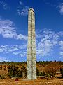 Obelisk of Axum, Ethiopia
 -
 Fall of the Berlin Wall, 1989
 -
 Artist's conception of Hadean Eon Earth, when it was much hotter and inhospitable to all forms of life. (from History of Earth)
 -

-
 Great Mosque of Kairouan, Tunisia, founded 670 CE
 -
 Tiktaalik, a fish with limb-like fins and a predecessor of tetrapods. Reconstruction from fossils about 375 million years old. (from History of Earth)
 -

-
 A reconstruction of human history based on fossil data. (from History of Earth)
 -
 Yggdrasil, an attempt to reconstruct the Norse world tree which connects the heavens, the world, and the underworld. (from World)
 -
 Earth's history with time-spans of the eons to scale. Ma means "million years ago". (from History of Earth)
 -
 A view of Earth with its global ocean and cloud cover, which dominate Earth's surface and hydrosphere; at Earth's polar regions, its hydrosphere forms larger areas of ice cover. (from Earth)
 -
 An animation of the changing density of productive vegetation on land (low in brown; heavy in dark green) and phytoplankton at the ocean surface (low in purple; high in yellow) (from Earth)
 -

-
 Change in average surface air temperature and drivers for that change. Human activity has caused increased temperatures, with natural forces adding some variability. (from Earth)
 -
 Pangaea was a supercontinent that existed from about 300 to 180 Ma. The outlines of the modern continents and other landmasses are indicated on this map. (from History of Earth)
 -
 Cuneiform inscription, eastern Turkey
 -
 Last Moon landing: Apollo 17 (1972)
 -
 Florence, birthplace of the Italian Renaissance
 -
 A banded iron formation from the 3.15 Ga Moodies Group, Barberton Greenstone Belt, South Africa. Red layers represent the times when oxygen was available; gray layers were formed in anoxic circumstances. (from History of Earth)
 -
Artist's impression of Earth during the later Archean, the largely cooled planetary crust and water-rich barren surface, marked by volcanoes and continents, features already round microbialites. The Moon, still orbiting Earth much closer than today and still dominating Earth's sky, produced strong tides. (from History of Earth)
-

-
 Angkor Wat temple complex, Cambodia, early 12th century
 -
 Machu Picchu, Inca Empire, Peru
 -
 Trilobites first appeared during the Cambrian period and were among the most widespread and diverse groups of Paleozoic organisms. (from History of Earth)
 -
 Carving of Persian and Median soldiers, Persepolis, Achaemenid Empire, 5th century BCE
 -
 A pillar at Göbekli Tepe
 -
 Great Pyramids of Giza, Egypt
 -
 Image of the physical world, captured by the Hubble Space Telescope (from World)
 -
 A view of Earth with different layers of its atmosphere visible: the troposphere with its clouds casting shadows, a band of stratospheric blue sky at the horizon, and a line of green airglow of the lower thermosphere around an altitude of 100 km, at the edge of space (from Earth)
 -
 Shanghai. China urbanized rapidly in the 21st century.
 -

-
 Chennakesava Temple, Belur, India
 -

-
 Lithified stromatolites on the shores of Lake Thetis, Western Australia. Archean stromatolites are the first direct fossil traces of life on Earth. (from History of Earth)
 -
 Ming dynasty section, Great Wall of China
 -
 The pale orange dot, an artist's impression of the early Earth which might have appeared orange through its hazy methane rich prebiotic second atmosphere. Earth's atmosphere at this stage was somewhat comparable to today's atmosphere of Titan. (from History of Earth)
 -

-
 Artist's impression of a Hadean landscape with the relatively newly formed Moon still looming closely over Earth and both bodies sustaining strong volcanism. (from History of Earth)
 -
 Benin Bronze head from Nigeria
 -
Pale orange dot, an artist's impression of Early Earth, featuring its tinted orange methane-rich early atmosphere (from Earth)
-
 Geologic map of North America, color-coded by age. From most recent to oldest, age is indicated by yellow, green, blue, and red. The reds and pinks indicate rock from the Archean.
 -
 Chloroplasts in the cells of a moss (from History of Earth)
 -
 Earth's axial tilt causing different angles of seasonal illumination at different orbital positions around the Sun (from Earth)
 -
 The replicator in virtually all known life is deoxyribonucleic acid. DNA is far more complex than the original replicator and its replication systems are highly elaborate. (from History of Earth)
 -
 Cross-section through a liposome (from History of Earth)
 -
 A schematic view of Earth's magnetosphere with solar wind flowing from left to right (from Earth)
 -
 A 2012 artistic impression of the early Solar System's protoplanetary disk from which Earth and other Solar System bodies were formed (from Earth)
 -
 Battle during the 1281 Mongol invasion of Japan
 -
 Earth's night-side upper atmosphere appearing from the bottom as bands of afterglow illuminating the troposphere in orange with silhouettes of clouds, and the stratosphere in white and blue. Next the mesosphere (pink area) extends to the orange and faintly green line of the lowest airglow, at about one hundred kilometers at the edge of space and the lower edge of the thermosphere (invisible). Continuing with green and red bands of aurorae stretching over several hundred kilometers. (from Earth)
 -
 Peopling of the world, the Southern Dispersal scenario
 -
 "Lucy", the first Australopithecus afarensis skeleton found, was only 1.06 m (3 ft 6 in) tall.
 -
 Satellite time lapse imagery of Earth's rotation showing axis tilt (from Earth)
 -
 Vitruvian Man by Leonardo da Vinci epitomizes the advances in art and science seen during the Renaissance. (from History of Earth)
 -
 Artist's impression of the enormous collision that probably formed the Moon (from History of Earth)
 -
 Japanese depiction of a Portuguese carrack. European maritime innovations led to proto-globalization.
 -

-
 Taj Mahal, Mughal Empire, India
 -
 Ajloun Castle, Jordan
 -

-
 Earth's western hemisphere showing topography relative to Earth's center instead of to mean sea level, as in common topographic maps (from Earth)
 -

-
 Artist's conception of Devonian flora (from History of Earth)
 -
 COVID-19 pandemic, 2020 (from Human history)
 -
 Standing Buddha from Gandhara, 2nd century CE
 -
 An artist's impression of ice age Earth at glacial maximum. (from History of Earth)


.jpg)


.jpg)


.svg)


.png)


.jpg)


.jpeg)

Megacities of the world -

Shenzhen is a city and special economic zone on the east bank of the Pearl River estuary on the central coast of the southern Chinese province of Guangdong, bordering Hong Kong to the south, Dongguan to the north, Huizhou to the northeast, and Macau to the southwest. With a population of 17.5 million in 2020, Shenzhen is the third most populous city by urban population in China after Shanghai and Beijing. The Port of Shenzhen is the world's fourth busiest container port.
Shenzhen roughly follows the administrative boundaries of Bao'an County, which was established in imperial times. The southern portion of Bao'an County became part of British Hong Kong after the Opium Wars, while the village of Shenzhen was on the border. Shenzhen railway station was the last stop on the mainland Chinese section of the Kowloon–Canton Railway, and Shenzhen's economy grew and it became a city by 1979. (Full article...)Did you know -

- ... that Henry Wilson Hodge served as the director of military railroads for the American Expeditionary Forces during World War I?
- ... that Earth 300 has designed a climate research vessel that would include a molten salt reactor and a quantum computer?
- ... that the 1995 Aigio earthquake caused the strongest ground acceleration ever recorded in Greece?
- ...that in 1819, members of the Catholic Tübingen school first published the Theologische Quartalschrift, which remains in print as the oldest journal of Catholic theology in the world?
- ... that the 2009 book Where Heaven and Earth Meet introduced the term "Sacred Esplanade" as a politically neutral term for the religious site in Jerusalem known as al-Haram al-Sharif or the Temple Mount?
- ... that Kuappi in Iisalmi, Finland, holds the Guinness world record for the smallest restaurant?
- ... that Alfred Egerton Cooper, a war artist who lost the use of an eye in World War I, painted airships?
- ... that Johanna Quaas, the world's oldest competitive gymnast, did a tandem skydive from about 3,000 meters (9,800 ft) in 2016, dedicating it to Queen Elizabeth II?
Countries of the world -

Guinea-Bissau (/ˌɡɪni bɪˈsaʊ/ GHIN-ee bi-SOW; Portuguese: Guiné-Bissau; Fula: 𞤘𞤭𞤲𞤫 𞤄𞤭𞤧𞤢𞥄𞤱𞤮, romanized: Gine-Bisaawo; Mandinka: ߖߌ߬ߣߍ߫ ߓߌߛߊߥߏ߫ Gine-Bisawo), officially the Republic of Guinea-Bissau (Portuguese: República da Guiné-Bissau [ʁɛˈpuβlikɐ ðɐ ɣiˈnɛ βiˈsaw]), is a country in West Africa that covers 36,125 square kilometres (13,948 sq mi) with an estimated population of 2,026,778. It borders Senegal to its north and Guinea to its southeast.
Guinea-Bissau was once part of the kingdom of Kaabu, as well as part of the Mali Empire. Parts of this kingdom persisted until the 18th century, while a few others had been under some rule by the Portuguese Empire since the 16th century. In the 19th century, it was colonised as Portuguese Guinea. Portuguese control was restricted and weak until the early 20th century, when its pacification campaigns solidified Portuguese sovereignty in the area. The final Portuguese victory over the last remaining bastion of mainland resistance came in 1915, with the conquest of the Papel-ruled Kingdom of Bissau by the Portuguese military officer Teixeira Pinto and the Wolof mercenary Abdul Injai. (Full article...)The Seven Wonders of Portugal (Portuguese: Sete Maravilhas de Portugal) is a list of cultural wonders located in Portugal. The creation of the list was supported by the Ministry of Culture and organized by the companies Y&R Brands S.A. and Realizar S.A.
Initially 793 national monuments of Portugal were listed by Instituto Português do Património Arquitectónico (IPPAR) as candidates, however in the first round of selections a board of experts reduced the number to 77. The contenders were further reduced to 21 finalist in four different categories by Conselho de Notáveis at the University of Évora. (Full article...)Related portals
Protected areas of the world -
-
Protected areas of Slovenia include one national park (Slovene: narodni park), three regional parks (regijski park), several natural parks (krajinski park), and hundreds of natural monuments (naravni spomenik) and monuments of designed nature (spomenik oblikovane narave). They cover about 12.5% of the Slovenian territory. Under the Wild Birds Directive, 26 sites totalling roughly 25% of the nation's land are "Special Protected Areas"; the Natura 2000 proposal would increase the totals to 260 sites and 32% of national territory. (Full article...)
-
Illinois has a variety of protected areas, including over 123 state-protected areas, dozens of federally protected areas, hundreds of county-level and municipal park areas. Illinois also contains sites designated as internationally important protected areas. These multiple levels of protection contribute to a statewide network of numerous recreation opportunities and conservation schemes, sometimes in a small area. For example, DeKalb County contains a 1,000-acre (4.0 km2) forest preserve system and a 1,500-acre (6.1 km2) state park (Shabbona Lake State Park); within DeKalb County, the DeKalb Park District in the City of DeKalb has a 700-acre (2.8 km2) park system. (Full article...)
-
This is a list of protected areas in Bulgaria which includes 3 national parks, 11 nature parks and 55 nature reserves. The national policy for governing and management of the protected areas is implemented by the Ministry of Environment and Water. The first nature park in Bulgaria and the Balkan Peninsula is Vitosha Nature Park, established in 1934. All of the nationally protected areas in Bulgaria are also part of the Natura 2000 network of protected natural areas in the territory of the European Union. Bulgaria has some of the largest Natura 2000 areas in the European Union covering 33.8% of its territory.
- Parks and reserves in italic letters are part of Global 200 ecoregions.
-
-
Desert landscape in Qatar
Protected areas of Qatar include:- Al Reem Biosphere Preserve (designated in 2007) is part of the World Network of Biosphere Reserves in the Arab States
- Al Shahaniyah Park in Al-Shahaniya
- Al Thakira Nature Reserve in Al Thakhira
- Al Wabra Wildlife Preservation
- Dahl Al Hammam Park, a sinkhole in Doha (entrance to the hole is now closed to the public)
- Khor Al Adaid Reserve in Khor Al Adaid
- Khor Al Adaid Fish Sanctuary
- Mudhlem Cave in Mukaynis
- Musfer Sinkhole in Salwa
- Ras Abrouq Nature Reserve (also known as Bir Zekreet (Zekreet Beach)) in Ras Abrouq
- Ras Ushairij Gazelle Conservation Park
- Umm Tais National Park
-
Kentucky's system of 44 state parks has been referred to as "the nation's finest" and experiences more repeat business annually than those of any other U.S. state. The state's diverse geography provides a variety of environments to experience. From mountain lakes to expansive caves to forests teeming with wildlife, park-goers have their choice of attractions, and they are all within a day's drive of each other.
Unless otherwise specified, data in the following lists are taken from Kentucky State Parks by Bill Bailey. (Full article...) -
The Protected areas of New South Wales include both terrestrial and marine protected areas. As of June 2020[update] there are 225 national parks in New South Wales. A number established since the late 1970s followed campaigns by local residents and environmentalists.
Based on the Collaborative Australian Protected Area Database (CAPAD) 2020 data there are 2136 separate terrestrial protected areas with a total land area of 7,696,641 hectares (19,018,810 acres) (9.61% of the state's area). CAPAD data also shows 18 marine protected areas with a total area of 348,849 hectares (862,020 acres), covering 39.63% of NSW waters. (Full article...) -
This list of protected areas of Quebec includes federally, provincially and municipally administered parks and wildlife reserves in Quebec, the largest province in Canada. (Full article...) -
The country of Burundi in Africa has the following national parks and other protected areas. (Full article...)
-
The National Parks of Argentina make up a network of 35 national parks in Argentina. The parks cover a very varied set of terrains and biotopes, from Baritú National Park on the northern border with Bolivia to Tierra del Fuego National Park in the far south of the continent. The Administración de Parques Nacionales (National Parks Administration) is the agency that preserves and manages these national parks along with Natural monuments and National Reserves within the country.
The headquarters of the National Parks Service are in downtown Buenos Aires, on Santa Fe Avenue. A library and information centre are open to the public. The administration also covers the national monuments, such as the Jaramillo Petrified Forest, and natural and educational reserves. (Full article...) -
-
Queensland is the second-largest state in Australia. As at 2020, it contained more than 1,000 protected areas. In August 2023, it was estimated a total of 14.5 million hectares or 8.38% of Queensland's landmass was protected. (Full article...)
-
Protected areas of the European Union are areas which need and/or receive special protection because of their environmental, cultural or historical value to the member states of the European Union.
(Full article...) -
This is a list of protected areas of Ontario that are administered by Government of Ontario. Ontario Parks and the Ministry of the Environment, Conservation and Parks are the provincial bodies responsible for managing these protected areas. (Full article...)
-
Protected areas of Eswatini include any geographical area protected for a specific use inside the landlocked country of Eswatini, in southern Africa.
Within Eswatini there is a mix of national, private and community-owned protected areas. They include national parks, nature reserves, wildlife sanctuaries and game reserves. (Full article...)

.jpg)
Selected world maps
-
 Only a few of the largest large igneous provinces appear (coloured dark purple) on this geological map, which depicts crustal geologic provinces as seen in seismic refraction data
 -
 A plate tectonics map with volcano locations indicated with red circles
 -
 Index map from the International Map of the World (1:1,000,000 scale)
 -
 Mollweide projection of the world
 -
 United Nations Human Development Index map by country (2016)
 -
 Time zones of the world
 -
 The world map by Gerardus Mercator (1569), the first map in the well-known Mercator projection
 -
 1516 map of the world by Martin Waldseemüller
 -
 The Goode homolosine projection is a pseudocylindrical, equal-area, composite map projection used for world maps.


World records
- List of Olympic records in athletics
- List of world records in athletics
- List of junior world records in athletics
- List of world records in masters athletics
- List of world youth bests in athletics
- List of IPC world records in athletics
- List of world records in canoeing
- List of world records in chess
- List of cycling records
- List of world records in track cycling
- List of world records in finswimming
- List of world records in juggling
- List of world records in rowing
- List of world records in speed skating
- List of world records in swimming
- List of IPC world records in swimming
- List of world records in Olympic weightlifting
Topics

Continents of Earth | ||||||||
|---|---|---|---|---|---|---|---|---|
| ||||||||
| ||||||||
| ||||||||


| Cenozoic Era (present–66.0 Ma) |
| ||||||||||||
|---|---|---|---|---|---|---|---|---|---|---|---|---|---|
| Mesozoic Era (66.0–252 Ma) |
| ||||||||||||
| Paleozoic Era (252–539 Ma) |
| ||||||||||||
| Proterozoic Eon (539 Ma–2.5 Ga) |
| ||||||||||||
| Archean Eon (2.5–4 Ga) | |||||||||||||
| Hadean Eon (4–4.6 Ga) | |||||||||||||
ka = kiloannum (thousands years ago); Ma = megaannum (millions years ago); Ga = gigaannum (billions years ago). See also: Geologic time scale • | |||||||||||||
| Locations | ||
|---|---|---|
| Related | ||

| |||||||||||||||||||
| |||||||||||||||||||
| |||||||||||||||||||

Economic classification of countries | |||||
|---|---|---|---|---|---|
| Three-World Model | |||||
| Gross domestic product (GDP) |
| ||||
| Gross national income (GNI) | |||||
| Wages | |||||
| Wealth | |||||
| Other national accounts | |||||
| Human development | |||||
| Digital divide | |||||
| Net international investment position (NIIP) | |||||
| Technological |
| ||||
|---|---|---|---|---|---|
| Sociological | |||||
| Ecological |
| ||||
| Biological |
| ||||
| Astronomical | |||||
| Eschatological |
| ||||
| Others |
| ||||
| Fictional | |||||
| Organizations | |||||
Categories

Wikimedia
The following Wikimedia Foundation sister projects provide more on this subject:
-
 Commons
Free media repository -
 Wikibooks
Free textbooks and manuals -
 Wikidata
Free knowledge base -
 Wikinews
Free-content news -
 Wikiquote
Collection of quotations -
 Wikisource
Free-content library -
 Wikispecies
Directory of species -
 Wikiversity
Free learning tools -
 Wikivoyage
Free travel guide -
 Wiktionary
Dictionary and thesaurus


