The Andes Portal

The Andes (/ˈændiːz/ AN-deez), Andes Mountains or Andean Mountain Range (Spanish: Cordillera de los Andes; Quechua: Anti) are the longest continental mountain range in the world, forming a continuous highland along the western edge of South America. The range is 8,900 km (5,530 mi) long and 200 to 700 km (124 to 435 mi) wide (widest between 18°S and 20°S latitude) and has an average height of about 4,000 m (13,123 ft). The Andes extend from north to south through seven South American countries: Venezuela, Colombia, Ecuador, Peru, Bolivia, Chile and Argentina.
Along their length, the Andes are split into several ranges, separated by intermediate depressions. The Andes are the location of several high plateaus—some of which host major cities such as Quito, Bogotá, Cali, Arequipa, Medellín, Bucaramanga, Sucre, Mérida, El Alto and La Paz. The Altiplano Plateau is the world's second-highest after the Tibetan Plateau. These ranges are in turn grouped into three major divisions based on climate: the Tropical Andes, the Dry Andes, and the Wet Andes.
The Andes Mountains are the highest mountain range outside Asia. The highest mountain outside Asia, Argentina's Aconcagua, rises to an elevation of about 6,961 m (22,838 ft) above sea level. The peak of Chimborazo in the Ecuadorian Andes is farther from the Earth's center than any other location on the Earth's surface, due to the equatorial bulge resulting from the Earth's rotation. The world's highest volcanoes are in the Andes, including Ojos del Salado on the Chile-Argentina border, which rises to 6,893 m (22,615 ft). (Full article...)
Selected articles
-

Cordón del Azufre is an inactive complex volcano located in the Central Andes, at the border of Argentina and Chile. It consists of three stages of volcanic cones and associated lava flows, and its activity is a consequence of the subduction of the Nazca Plate underneath the South American Plate. North of it are the dormant volcano Lastarria and the actively uplifting Lazufre region. (Full article...) -
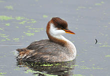
The Titicaca grebe (Rollandia microptera), also known as the Titicaca flightless grebe or short-winged grebe, is a grebe found on the altiplano of Peru and Bolivia. As its name implies, its main population occurs on Lake Titicaca. Lake Uru Uru and Poopó, the Rio Desaguadero, and small lakes that connect to Lake Titicaca in wet years, serve as "spillovers" territory. In the past, the population was larger and several of these lakes – such as Lakes Umayo and Arapa – apparently had and may still have permanent large colonies (BirdLife International 2006). It is sometimes placed in Podiceps or a monotypic genus Centropelma. Its local name is zampullín del Titicaca. (Full article...) -
Chimborazo (Spanish pronunciation: [tʃimboˈɾaso] ⓘ) is an inactive stratovolcano situated in the Cordillera Occidental range of the Andes. Its last known eruption is believed to have occurred around 550 A.D. Although not the tallest mountain in the Andes or on Earth relative to sea level, its summit is the farthest point on Earth's surface from the Earth's center, due to its location along the planet's equatorial bulge. Chimborazo's height is 6,263 m (20,548 ft), well below that of Mount Everest (8,849 m).
Chimborazo is the highest mountain in Ecuador and the 39th highest peak in the entire Andes. It is a popular destination for mountaineering due to its challenging climbing routes, which involve traversing snow, ice, and rocky terrain. (Full article...) -

The llama (/ˈlɑːmə/; Spanish pronunciation: [ˈʎama] or [ˈʝama]) (Lama glama) is a domesticated South American camelid, widely used as a meat and pack animal by Andean cultures since the pre-Columbian era.
Llamas are social animals and live with others as a herd. Their wool is soft and contains only a small amount of lanolin. Llamas can learn simple tasks after a few repetitions. When using a pack, they can carry about 25 to 30% of their body weight for 8 to 13 km (5–8 miles). The name llama (in the past also spelled "lama" or "glama") was adopted by European settlers from native Peruvians. (Full article...) -
Quilotoa (Spanish pronunciation: [kiloˈto.a]) is a water-filled crater lake and the most western volcano in the Ecuadorian Andes. The 3-kilometre (2 mi)-wide caldera was formed by the collapse of this dacite volcano following a catastrophic VEI-6 eruption about 800 years ago, which produced pyroclastic flows and lahars that reached the Pacific Ocean, and spread an airborne deposit of volcanic ash throughout the northern Andes. This last eruption followed a dormancy period of 14,000 years and is known as the 1280 Plinian eruption. The fourth (of seven) eruptive phase was phreatomagmatic, indicating that a Crater lake was already present at that time. The caldera has since accumulated a 250-metre-deep (820 ft) crater lake, which has a greenish color as a result of dissolved minerals. Fumaroles are found on the lake floor and hot springs occur on the eastern flank of the volcano.
Quilotoa is a site of growing popularity. The route to the "summit" (the small town of Quilotoa) is generally traveled by hired truck or bus from the town of Zumbahua 17 kilometres (11 mi) to the South, or more commonly by bus from Latacunga. Visitors have to pay two US dollars each to enter Quilotoa. There are a number of simple hostels in the immediate area offering services such as mules and guides. Activities include a four to five-hour hike around the caldera (whose diameter is just over 3 kilometres (2 mi)). The caldera rim is highly irregular and reaches its maximum elevations 3,810 metres (12,500 ft) to the N, 3,894 metres (12,776 ft) to the NW and 3,915 metres (12,844 ft) to the SE, at three lava domes. The 10-kilometre (6 mi) hike is sandy and steep in places and can be quite taxing, particularly if there is fog. (Full article...) -
Artesonraju is a pyramidal mountain peak located near the city of Caraz in the Cordillera Blanca mountain range in the Peruvian Andes. It is located at the Peruvian province of Huaylas and its slopes are within two cities: Santa Cruz and Caraz. Its summit has an elevation of 6,025 metres (19,767 ft) (or 5,999 metres (19,682 ft) according to the IGN-Peru map). It is one of many prominent peaks (2772 metres) located within the boundaries of Peru's Huascarán National Park.
Artesonraju has two distinguished climbing routes. Due to their difficulties, Artesonraju is seldom successfully climbed in comparison to other well known mountains in the Cordillera Blanca. This mountain is the inspiration for the current production logo for Paramount Pictures. (Full article...) -
Chinchillas are either of two species (Chinchilla chinchilla and Chinchilla lanigera) of crepuscular rodents of the parvorder Caviomorpha, and are native to the Andes mountains in South America. They live in colonies called "herds" at high elevations up to 4,270 m (14,000 ft). Historically, chinchillas lived in an area that included parts of Bolivia, Peru and Chile, but today, colonies in the wild are known only in Chile. Along with their relatives, viscachas, they make up the family Chinchillidae. They are also related to the chinchilla rat.
The chinchilla has the densest fur of all mammals that live on land, with around 20,000 hairs per square centimeter and 50 hairs growing from each follicle. In the water, the sea otter has a denser coat. The chinchilla is named after the Chincha people of the Andes, who once wore its dense, velvet-like fur. By the end of the 19th century, chinchillas had become quite rare after being hunted for their ultra-soft fur. Most chinchillas currently used by the fur industry for clothing and other accessories are farm-raised. Domestic chinchillas descended from C. lanigera are sometimes kept as pets, and may be considered a type of pocket pet. (Full article...) -

The Puracé National Natural Park (Spanish: Parque Nacional Natural Puracé) is a national park located in the Andean region of Colombia, southeast of the city of Popayán in the Cordillera Central range. Its main feature is the active stratovolcano Puracé, one of Colombia's most active volcanoes. Four of the country's most important rivers originate within the area: Magdalena River, Cauca River, Japurá River and Patía River. (Full article...) -
Corazón (Spanish: "heart") is an inactive, eroded stratovolcano of Ecuador, situated about 30 km southwest of Quito in the western slopes of the Andes. (Full article...) -
Cerro Bonete is a mountain in the north of the province of La Rioja, Argentina, near the provincial border with Catamarca. Its summit is 6,759 m above mean sea level, making it the fifth-highest separate mountain in the Americas (after Aconcagua, Ojos del Salado, Monte Pissis, and Huascaran). SRTM data disproves the frequently-made claim that its summit is 6,872 m above sea level.
Within the last 3.5 million years, volcanic activity at Cerro Bonete has formed lava domes of dacite and rhyodacite. (Full article...) -
Socompa is a large stratovolcano at the border of Argentina and Chile with an elevation of 6,051 metres (19,852 ft) metres. Part of the Chilean and Argentine Andean Volcanic Belt (AVB), it is within the Central Volcanic Zone, one of the various segments of the AVB. This part of the Andean volcanic belt begins in Peru and runs first through Bolivia and Chile, and then through Argentina and Chile, and contains about 44 active volcanoes. Socompa lies close to the pass of the same name, where the Salta-Antofagasta railway crosses the border.
Socompa is known for its large debris avalanche, which was formed 7,200 years ago when most of the northwestern slope collapsed and slid down, forming an extensive deposit. It was at first considered to be either a moraine or a nuee ardende deposit, until the 1980 eruption of Mount St. Helens prompted awareness of the instability of volcanic edifices and the existence of large scale collapses on them. The Socompa collapse is among the largest known with a volume of 19.2 cubic kilometres (4.6 cu mi) and covers a surface area of 490 square kilometres (190 sq mi), and its features are well preserved by the arid climate. Notable are the large toreva blocks which were left behind within the collapse crater. After the landslide, the volcano was rebuilt by the effusion of lava flows and much of the scar is now filled in. (Full article...) -
Siula Grande is a mountain in the Huayhuash mountain range in the Peruvian Andes. It is 6,344 metres (20,814 ft) high and has a subpeak, Siula Chico, 6,260 m (20,540 ft) high. (Full article...) -
Michincha is a stratovolcano on the border of Bolivia and Chile. It is part of an east–west trending ridge of stratovolcanoes. To its east lies Olca. The only historical activity from the complex was a flank eruption from 1865 to 1867. (Full article...)
-
Llullaillaco (Spanish pronunciation: [ʎuʎajˈʎako]) is a dormant stratovolcano on the border between Argentina (Salta Province) and Chile (Antofagasta Region). It lies in the Puna de Atacama, a region of tall volcanic peaks on a high plateau close to the Atacama Desert, one of the driest places in the world. Its maximum elevation is most commonly given as 6723 m, making it the second- or third-highest volcano in the world. Despite its height, it is not clear whether the volcano has any glaciers or merely patches of perennial snow and ice. Between 3700 m and 5000 m elevation there is a sparse plant cover, while at lower altitudes the climate is too dry for plants to grow. A species of mouse on Llullaillaco is the highest-living known vertebrate species.
The volcano formed during the Pleistocene in two stages, named Llullaillaco I and Llullaillaco II. The oldest rocks are about 1.5 million years old. About 150,000 years ago, the volcano's southeastern flank collapsed, generating a debris avalanche that reached as far as 25 km from the summit. During the last stage, three conspicuous lava flows were emplaced on the summit. The youngest dated rocks are 930 ± 140 years old, but there are reports of activity from the 19th century. (Full article...) -
Mount Tarn is a small mountain located on the southernmost part of the Strait of Magellan, in Brunswick Peninsula, about 70 km south of Punta Arenas, Chile. It is in the southern extreme of continental Chile very close to Cape Froward, surrounded by historic places such as Fort Bulnes and Puerto del Hambre (Port Famine).
From the summit it is possible to see the Strait of Magellan, Dawson and Tierra del Fuego islands, and many other smaller ones; the Darwin Mountain Range, Mount Sarmiento, and most of the Brunswick Peninsula. (Full article...) -
The Nevado del Quindío is an inactive volcano located in the Central Cordillera of the Andes in central Colombia. The summit marks the tripoint of the departments of Risaralda, Quindío and Tolima, and is also the highest point of the departments of Risaralda and Quindío. The mountain is one of the highest peaks in the Los Nevados National Natural Park, which is a wildlife sanctuary. There are no historical records of any eruption. The andesitic volcano is located on top of the Palestina Fault.
The snow fields and glaciers in the mountain are decreasing in a progressive way, about ten percent annually since the first scientific measures in the late 1980s, presumably because of global warming. (Full article...) -
Touching the Void is a 1988 book by Joe Simpson, recounting his and Simon Yates's near fatal descent after climbing the 6,344-metre (20,814 ft) peak Siula Grande in the Peruvian Andes. Approximately 15% of the book is written by Yates. It has sold over a million copies and has been translated into over 20 languages. (Full article...)
-
Chacaltaya (Mollo language for "bridge of winds" or "winds meeting point", Aymara for "cold road"[dubious ]) is a mountain in the Cordillera Real, one of the mountain ranges of the Cordillera Oriental, itself a range of the Bolivian Andes. Its elevation is 5,421 meters (17,785 ft). Chacaltaya's glacier — which was as old as 18,000 years — had an area of 0.22 km2 (0.085 sq mi) in 1940, which had been reduced to 0.01 km2 (0.0039 sq mi) in 2007 and was completely gone by 2009. Half of the meltdown, as measured by volume, took place before 1980. The final meltdown after 1980, due to missing precipitation and the warm phase of El Niño, resulted in the glacier's disappearance in 2009. The glacier was located about 30 kilometers (19 mi) from La Paz, near Huayna Potosí mountain. (Full article...) -
Antisana is a stratovolcano of the northern Andes, in Ecuador. It is the fourth highest volcano in Ecuador, at 5,753 metres (18,875 ft), and is located 50 kilometres (31 mi) SE of the capital city of Quito.
Antisana presents one of the most challenging technical climbs in the Ecuadorian Andes. Next to the Pichincha, Cotopaxi, Tungurahua and Chimborazo, the Antisana belongs to the five volcanic mountains that the Prussian-born explorer Alexander von Humboldt tried to climb in 1802 during his American journey. (Full article...) -
Pico El Toro is a mountain in the Andes of Venezuela. It has a height of 4755 metres. (Full article...)
-
Salcantay, Salkantay or Sallqantay (in Quechua) is the highest peak in the Vilcabamba mountain range, part of the Peruvian Andes. It is located in the Cusco Region, about 60 km (40 mi) west-northwest of the city of Cusco. It is the 38th-highest peak in the Andes and the twelfth-highest in Peru. However, as a range highpoint in deeply incised terrain, it is the second most topographically prominent peak in the country, after Huascarán.
Salcantay's proximity to Machu Picchu makes trekking around it an alternative to the oversubscribed Inca Trail; this is known as the Salkantay trek. (Full article...) -
Tupungato, one of the highest mountains in the Americas, is a massive Andean lava dome dating to Pleistocene times. It lies on the Argentina–Chile border, between the Chilean Metropolitan Region (near a major international highway about 80 km (50 mi) east of Santiago) and the Argentine province of Mendoza, about 100 km (62 mi) south of Aconcagua, the highest peak of both the Southern and Western hemispheres. Immediately to its southwest is the active Tupungatito volcano (literally, little Tupungato), which last erupted in 1987.
Tupungato Department, an important Argentine wine-producing region in Mendoza province, is named for the volcano. Recent Chilean mapping indicates it has a height of 6635m. (Full article...) -
Paruma is a stratovolcano that lies on the border of Bolivia and Chile. It is part of a ridge that contains several stratovolcanos. Paruma lies at the eastern end of the ridge, with Olca to its west. The older volcano Paruma lies to east of Paruma. Paruma has clearly been active during the Holocene, with many morphologically young lava flows on its flanks. It also has persistent fumaroles. One lava flow in particular extends for 7 kilometres to the south-east of the peak. Historical activity along the ridge has been confined to one eruption from 1865 to 1867, the character of which is not precisely known. (Full article...)
-
Huandoy (probably from Quechua wantuy, to transfer, to transpose, to carry, to carry a heavy load) or Tullparaju (possibly from Quechua tullpa rustic cooking-fire, stove, rahu snow, ice, mountain with snow,) is a mountain located inside Huascarán National Park in Ancash, Peru. It is the second-tallest peak of the Cordillera Blanca section of the Andes, after Huascarán. These two peaks are rather nearby, separated only by the Llanganuco glacial valley (which contains the Llanganuco Lakes) at 3,846 m asl.
It is a snow-capped mountain with four peaks arranged in the form of a fireplace, the tallest of which is 6,395 m. The four peaks are each over 6,000 m, and are:- Huandoy (6,395 m)
- Huandoy-West (6,356 m)
- Huandoy-South (6,160 m)
- Huandoy-East (6,000 m)
-
Telmatobius macrostomus, also known as the Lake Junin (giant) frog or Andes smooth frog, is a very large and endangered species of frog in the family Telmatobiidae. This completely aquatic frog is endemic to lakes and associated waters at altitudes of 4,000–4,600 m (13,100–15,100 ft) in the Andes of Junín and Pasco in central Peru. It has been introduced to slow-moving parts of the upper Mantaro River, although it is unclear if this population still persists.
Together with the closely related Amable Maria frog (T. brachydactylus), it is sometimes placed in the genus Batrachophrynus. (Full article...)


.jpg)


-2.JPG)


.jpg)

.png)

.jpg)


Did you know...
- ... that the 1930s Polish Andean expeditions have been credited with several first ascents and the tracing of a new route to the summit of Aconcagua, the Andes' highest peak?
Need help?
Do you have a question about Andes that you can't find the answer to?
Consider asking it at the Wikipedia reference desk.
General images
-
 Map of the Andean region of South America (from Andean agriculture)
 -

-
 Laguna de Sonso tropical dry forest in Northern Andes (from Andes)
 -
 Bolivian Andes (from Andes)
 -
 Paleogeography of the Late Cretaceous South America. Areas subject to the Andean orogeny are shown in light grey while the stable cratons are shown as grey squares. The sedimentary formations of Los Alamitos and La Colonia that formed in the Late Cretaceous are indicated. (from Andean orogeny)
 -
 Nevado del Huila, Colombia (from Andes)
 -

-
 Syncline next to Nordenskjöld Lake in Torres del Paine National Park. The syncline formed during the Andean orogeny. (from Andean orogeny)
 -

-

-
 Pico Humboldt at sunset (from Andes)
 -
 Topographic map of the Andes by the NASA. The southern and northern ends of the Andes are not shown. The Bolivian Orocline is visible as a bend in the coastline and the Andes lower half of the map. (from Andean orogeny)
 -
 Simplified sketch of the present-situation along most of the Andes (from Andean orogeny)
 -

-
 A male Andean cock-of-the-rock, a species found in humid Andean forests and the national bird of Peru (from Andes)
 -
 Parinacota, Bolivia/Chile (from Andes)
 -

-
 Central Andes (from Andes)
 -
 Irrigating land in the Peruvian Andes (from Andes)
 -
 Frederic Edwin Church, Heart of the Andes, 1859. (from Andes)
 -
 Pacha Mama Ceremony (from Andean agriculture)
 -
 The seaward tilting of the sedimentary strata of Salto del Fraile Formation in Peru was caused by the Andean orogeny. (from Andean orogeny)
 -

-
 Ulluco: Common crop of the Andean region (from Andean agriculture)
 -
 Mashua tubers (from Andean agriculture)
 -

-
 View of Cuernos del Paine in Torres del Paine National Park, Chile (from Andes)
 -

-

-
 Peruvian farmers sowing maize and beans (from Andes)
 -

-
 Map of a north-south sea-parallel pattern of rock ages in western Colombia. This pattern is a result of the Andean orogeny. (from Andean orogeny)
 -
 Aerial view of Valle Carbajal in the Tierra del Fuego. The Andes range is about 200 km (124 mi) wide throughout its length, except in the Bolivian flexure where it is about 640 kilometres (398 mi) wide. (from Andes)


.jpg)


.jpg)
.jpg)
.JPG)


.jpg)

%E2%80%93Valle_Carbajal_01.jpg)
Subcategories

- Select [►] to view subcategories
Related portals
Subtopics
Associated Wikimedia
The following Wikimedia Foundation sister projects provide more on this subject:
-
 Commons
Free media repository -
 Wikibooks
Free textbooks and manuals -
 Wikidata
Free knowledge base -
 Wikinews
Free-content news -
 Wikiquote
Collection of quotations -
 Wikisource
Free-content library -
 Wikiversity
Free learning tools -
 Wiktionary
Dictionary and thesaurus


