Wikipedia:Graphics Lab/Map workshop/Archive/Sep 2012
Stale edit
Norwegian municipalities edit
-
 Base map

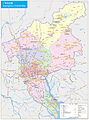
Article(s): Taxation in Norway
Request: So I want this map which has all object IDs after ISO 3166-2:NO colorded after this table. I know how to do this manually (in Inkscape), but I got a bunch of different versions of this map for different uses. Is there any way to use a programe or script to color the map from a spreadsheet or equalent? It would make it a lot easier to make good illustrations for me. I've tried some basic search and replace, but not with great success. Røed (talk · no) 23:49, 6 July 2012 (UTC)
Graphist opinion:
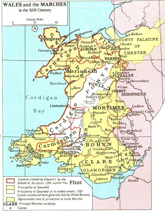
Medieval Wales edit
-
 Wales in 1267
 -
 Wales after 1284


Article(s): Principality of Wales
Request: The first is the current infobox map. The second is in the article for the post-1284 period. I think the infobox map should be a composite of the two to give a better representation of the entire history of the principality. My suggestion is to use the Wales in 1267 map as the base and outline in red on it the areas which are in BLUE and GREEN from the Wales after 1284 map (They are the areas within the Principality after 1284). No need to indicate the boundaries shown on the 1284 map inside the blue and green. I would also suggest outlining the coast red as well to make it clear which side of the line the principality is on (and because one of the areas, Anglesey, is an island).
The maps appear to be drawn from this source. If, in the alternative, anyone would like to start from scratch that may be good. All that needs to be shown is three blocks of territories: the original territory in Gwynedd, (called principality of Gwynedd in the source), the principality at its widest extent in 1267 and the principality after 1284 (outlined in red on the source map).
Thanks. DeCausa (talk) 06:48, 6 July 2012 (UTC)
Graphist opinion(s):
SVG World Map with Country Names edit
There doesn't seem to be one of those here or in Wikimedia Commons.
Request: Create an SVG-format world map with country names.
Graphist opinion:
Adapting this from any current world map would be very challenging due to the small size of many countries. Also, that, combined with name lengths, would make any such map basically impossible to read. - Presidentman talk · contribs Random Picture of the Day (Talkback) 17:24, 7 July 2012 (UTC)
EU institutions map edit
-
 Heraldic map of locations of European Union institutions

Article(s): Location of European Union institutions
Request: Add the Hague as the seat of Europol. -- Presidentman talk · contribs Random Picture of the Day (Talkback) 22:12, 2 July 2012 (UTC)
Graphist opinion(s):
Vector blank Guangzhou map with district subdivisions edit
-
 A
A -
 B
B -
 C
C


Article(s): Guangzhou, Template:Guangzhou
Request: Can a blank SVG map of Guangzhou with district subdivisions be created in the style of image A above? Such an image will be useful for vectorizing images like image B above. Image A is not immediately suitable for vectorization because the outline of the southmost Nansha District is noticeably incorrect. The outline of Nansha District in image B is incorrect, too. Image C is a government-published map and can be used for reference. The new map can be of a lower level of detail than that, though. Kxx (talk | contribs) 02:22, 13 July 2012 (UTC)
Graphist opinion(s):
Map of central, eastern and south-eastern Europe edit
-
 Description of image
 -
 2nd image (If there is one)


Article(s):
Request: Is there any chance of making a map that shows part of Europe in conic projection that has latitudes between 37° and 61° and longitudes between 11° and 39°? Perunova straža (talk) 11:14, 16 July 2012 (UTC)
Graphist opinion(s):
Spread of bovine tuberculosis edit
Article(s): Badger culling in the United Kingdom
Request: Please see the copyrighted maps here; what I'm looking for is a freely-licensed equivalent of the one on the far right, showing the current extent of the disease. If someone's kind enough to accept this request, they will need the raw dataset which is here and a blank map of Great Britain. Thanks in advance and all the best—S Marshall T/C 21:15, 21 July 2012 (UTC)
Graphist opinion(s):
Map showing the range of the Dodo edit
-
 Original GIF
 -
 Someone replaced it with this
 -
 This is from Mauritius, but it includes other islands


.svg)
Article(s): Dodo
Request: We need a map that shows the main island of Mauritius for this potential FA. Mauritius is too small, so the range can't be seen in the current map without clicking on it. It also looks like there's some huge blue continent next to Russia. We need a map that only shows the main island (the biggest circle in the third image.) I prefer the style of the GIF, doesn't really matter though.Thanks! ʝunglejill 12:13, 14 June 2012 (UTC)
Graphist opinion(s):
Can File:Mauritius blank map.svg be used? - Presidentman talk · contribs Random Picture of the Day (Talkback) 19:30, 5 July 2012 (UTC)
or File:Mauritius (orthographic projection).svg? seems to be more or less what's being requested. Kmusser (talk) 15:46, 26 July 2012 (UTC)
Malayan and Singapore campaigns 1941-42 edit
Article(s): 2/18th Battalion (Australia)
Request: Create two maps. One depicting the 2/18th's dispositions during its ambush of the Japanese on 25 January 1941 during the Malayan campaign and another showing its locations during the Singapore in early 1942. The article is currently undergoing a Military history A-class review and I would like to take it to FAC shortly. Sources can be found in the Official History by Wigmore here (the Nithsdale ambush, p. 267; Singapore defensive positions, p. 310). Also, if anyone has access to Chris Coulthard-Clark's Encyclopedia of Australian Battles, there is a good source on p. 201. Regards, AustralianRupert (talk) 13:06, 26 July 2012 (UTC)
Graphist opinion(s):
Resolved edit
Requesting a map for Yuna River edit
-
 The Yuna River is located near the cities of Bonao and Cotui. It begins south of Bonao and has its mouth at the Samana Bay in the eastern part of the Dominican Republic.
 -
 New map


Article(s): Yuna River
Request: The Yuna River article needs a map of the river and its watershed within the Dominican Republic. If it's major tributary: The Camu River would be highlighted in the map, that would be a plus. Your collaboration would be greatly appreciated. Thank you. 64.121.121.159 (talk) 08:49, 19 August 2012 (UTC)
- Map looks great, thank you very much! 156.12.200.144 (talk) 05:57, 31 August 2012 (UTC)
Graphist opinion(s): I'll do this one. Kmusser (talk) 18:10, 30 August 2012 (UTC) Done. Kmusser (talk) 20:49, 30 August 2012 (UTC)
Unshade some areas of a map edit
-
 In brief: Map of countries with socialist MEPS. Red shows countries with more than one. Pink with just one.

Article(s): Progressive Alliance of Socialists and Democrats
Request: The only areas that should be shaded pink are Luxembourg, Latvia and Estonia. Please can you unshade in the water in the Netherlands and Lake Vanern in Sweden, they appear to have been coloured pink by mistake and should be white.Peter Talk page 21:50, 2 September 2012 (UTC)
Graphist opinion(s): ![]() Done. They were pink because they were an opaque overlay over the underlying land, which was red. This coincidentally looked the same as the pink used for some other countries. They're white now, but prima facie 1/>1 does not seem that useful a map. CMD (talk) 22:18, 2 September 2012 (UTC)
Done. They were pink because they were an opaque overlay over the underlying land, which was red. This coincidentally looked the same as the pink used for some other countries. They're white now, but prima facie 1/>1 does not seem that useful a map. CMD (talk) 22:18, 2 September 2012 (UTC)
Armenia–Hungary relations edit
-
 Current image

.svg)
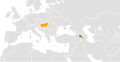
Article(s): Armenia–Hungary relations
Request: Can we get a smaller map focused on europe/eastern europe so the 2 countries are viewable? On the world map you cant see them on the page. Lihaas (talk) 06:34, 4 September 2012 (UTC)
Graphist opinion(s): ![]() Done Centred, hopefully a good balance between visibility and being able to place their location. CMD (talk) 21:24, 4 September 2012 (UTC)
Done Centred, hopefully a good balance between visibility and being able to place their location. CMD (talk) 21:24, 4 September 2012 (UTC)
Question about how we add a map to Armenia-Cyprus relations article edit
Article(s): Armenia - Cyprus relations
Request: Do something with them... IsrArmen (talk) 10:28, 4 September 2012 (UTC)
- Comment: Do you have a particular image in mind? Kevin Rutherford (talk) 05:29, 12 September 2012 (UTC)
Graphist opinion(s):