| {{{1}}} |
|2=
|2=

The Andes (/ˈændiːz/ AN-deez), Andes Mountains or Andean Mountain Range (Spanish: Cordillera de los Andes; Quechua: Anti) are the longest continental mountain range in the world, forming a continuous highland along the western edge of South America. The range is 8,900 km (5,530 mi) long and 200 to 700 km (124 to 435 mi) wide (widest between 18°S and 20°S latitude) and has an average height of about 4,000 m (13,123 ft). The Andes extend from South to North through seven South American countries: Argentina, Chile, Bolivia, Peru, Ecuador, Colombia, and Venezuela.
Along their length, the Andes are split into several ranges, separated by intermediate depressions. The Andes are the location of several high plateaus—some of which host major cities such as Quito, Bogotá, Cali, Arequipa, Medellín, Bucaramanga, Sucre, Mérida, El Alto, and La Paz. The Altiplano Plateau is the world's second-highest after the Tibetan Plateau. These ranges are in turn grouped into three major divisions based on climate: the Tropical Andes, the Dry Andes, and the Wet Andes. (Full article...)
Selected general articles
-

Lake Carhuacocha (possibly from Quechua qarwa leaf worm, larva of a beetle; pale, yellowish, golden, qucha lake,) is a lake in Peru located in the Huanuco Region, Lauricocha Province, on the border of the districts of Jesús and Queropalca. It lies on the east side of the Huayhuash mountain range. The lake is about 1.5 km long and 0.44 km at its widest point. (Full article...) -
Telmatobius culeus, commonly known as the Titicaca water frog or Lake Titicaca frog, is a medium-large to very large and endangered species of frog in the family Telmatobiidae. It is entirely aquatic and found only in the Lake Titicaca basin, including rivers that flow into it and smaller connected lakes like Arapa, Lagunillas and Saracocha, in the Andean highlands of Bolivia and Peru. In reference to its excessive amounts of skin, it has jokingly been referred to as the Titicaca scrotum (water) frog.
It is closely related to the more widespread and semiaquatic marbled water frog (T. marmoratus), which also occurs in shallow, coastal parts of Lake Titicaca, but lacks the excessive skin and it is generally smaller (although overlapping in size with some forms of the Titicaca water frog). (Full article...) -
Lastarria is a 5,697 metres (18,691 ft) high stratovolcano that lies on the border between Chile and Argentina. It is remote, and the surroundings are uninhabited but can be reached through an unpaved road. The volcano is part of the Central Volcanic Zone, one of the four segments of the volcanic arc of the Andes. Over a thousand volcanoes—of which about 50 are active—lie in this over 1,500 kilometres (930 mi) long chain of volcanoes, which is generated by subduction of the Nazca Plate beneath the South American Plate.
The volcano is constituted by two volcanic edifices that form a ridge, and one subsidiary lava flow field southwest of the main volcanoes. The main edifice features several aligned craters that form a line. There is no recorded eruptive activity, but the volcano displays vigorous fumarolic activity on its northern side and within the craters. It is located on top of older volcanic rocks and features both andesite and dacite. (Full article...) -
The Pico Pan de Azúcar, at 4680 meters above sea level, is the ninth highest mountain of Venezuela, and the third highest of the Sierra de la Culata range in the Mérida State. Its name, which translates as "Bread of Sugar", is due to the sandy slopes of the mountain, which resembles "Pan dulce", a kind of bread sprinkled with sugar eaten in the country. The summit offers a scenic view, including Lake Maracaibo, Sierra Nevada de Mérida and the surrounding mountains of the Sierra de la Culata. (Full article...)
-
Cerro Macá is a stratovolcano located to the north of the Aisén Fjord and to the east of the Moraleda Channel, in the Aysén del General Carlos Ibáñez del Campo Region of Chile. This glacier-covered volcano lies along the regional Liquiñe-Ofqui Fault Zone.
Cerro Macá is a relatively small volcano with a volume of only 39 cubic kilometres (9.4 cu mi). It has a summit elevation of approximately 2,300 m above sea level and features glaciers that in 2011 covered an area of 27.62 square kilometres (10.66 sq mi). The edifice is partially eroded and a sector collapse is probably the origin of a large steep sided depression in the summit area. Pyroclastic cones with associated lava flows are found on its southwestern flank but also on the other slopes of the volcano, as far down as sea level and in the Bahia Aysen. (Full article...) -
Nevado del Ruiz (Spanish pronunciation: [neβaðo ðel ˈrwis]), also known as La Mesa de Herveo (English: Mesa of Herveo, the name of the nearby town) is a volcano on the border of the departments of Caldas and Tolima in Colombia, being the highest point of both. It is located about 130 km (81 mi) west of the capital city Bogotá. It is a stratovolcano composed of many layers of lava alternating with hardened volcanic ash and other pyroclastic rocks. Volcanic activity at Nevado del Ruiz began about two million years ago, during the Early Pleistocene or Late Pliocene, with three major eruptive periods. The current volcanic cone formed during the present eruptive period, which began 150,000 years ago.
The volcano usually generates Vulcanian to Plinian eruptions, which produce swift-moving currents of hot gas and rock called pyroclastic flows. These eruptions often cause massive lahars (mud and debris flows), which pose a threat to human life and the environment. The impact of such an eruption is increased as the hot gas and lava melt the mountain's snowcap, adding large quantities of water to the flow. On November 13, 1985, a small eruption produced an enormous lahar that buried and destroyed the town of Armero in Tolima, causing an estimated 25,000 deaths. This event later became known as the Armero tragedy—the deadliest lahar in recorded history. Similar but less deadly incidents occurred in 1595 and 1845, consisting of a small explosive eruption followed by a large lahar. (Full article...) -
Nevado Ojos del Salado is a dormant complex volcano in the Andes on the Argentina–Chile border. It is the highest volcano on Earth and the highest peak in Chile. The upper reaches of Ojos del Salado consist of several overlapping lava domes, lava flows and volcanic craters, with sparse ice cover. The complex extends over an area of 70–160 square kilometres (27–62 sq mi) and its highest summit reaches an altitude of 6,893 metres (22,615 ft) above sea level. Numerous other volcanoes rise around Ojos del Salado.
Being close to the Arid Diagonal of South America, the mountain has extremely dry conditions, which prevent the formation of substantial glaciers and a permanent snow cover. Despite the arid climate, there is a permanent crater lake about 100 m (330 ft) in diameter at an elevation of 6,480 metres (21,260 ft)-6,500 metres (21,300 ft) within the summit crater and east of the main summit. This is the highest lake of any kind in the world. Owing to its altitude and the desiccated climate, the mountain lacks vegetation. (Full article...) -
Pico El León is a mountain in the Andes of Venezuela. It has a height of 4740 metres. (Full article...) -
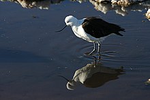
The Andean avocet (Recurvirostra andina) is a large wader in the avocet and stilt bird family, Recurvirostridae. It is resident in the Andes, breeding above 3500 m in northwestern Argentina, western Bolivia, northern Chile and southern Peru. (Full article...) -
The Wet Andes (Spanish: Andes húmedos) is a climatic and glaciological subregion of the Andes. Together with the Dry Andes it is one of the two subregions of the Argentine and Chilean Andes. The Wet Andes runs from a latitude of 35°S to Cape Horn at 56°S. According to Luis Lliboutry the Wet Andes can be classified after the absence of penitentes. In Argentina well developed penitentes are found as south as on Lanín Volcano (40°S). Another difference is that the Wet Andes is largely devoid of rock glaciers. The glaciers of the Wet Andes have a far more stable line of equilibrium than those of the Dry Andes due to summer precipitations, low thermal oscillations and an overall high moisture. (Full article...) -
The Andean cock-of-the-rock (Rupicola peruvianus), also known as tunki (Quechua), is a large passerine bird of the cotinga family native to Andean cloud forests in South America. It is the national bird of Peru. It has four subspecies and its closest relative is the Guianan cock-of-the-rock.
The Andean cock-of-the-rock exhibits marked sexual dimorphism; the male has a large disk-like crest and scarlet or brilliant orange plumage, while the female is significantly darker and browner. Gatherings of males compete for breeding females with each male displaying his colourful plumage, bobbing and hopping, and making a variety of calls. After mating, the female makes a nest under a rocky overhang, incubates the eggs, and rears the young by herself. (Full article...) -
Cumbal is a stratovolcano of the Caribe Terrane, located at the Nudo de los Pastos in Nariño, Colombia. It is the southernmost historically active volcano of Colombia and is together with Chiles and Azufral one of the few volcanoes of the Western Ranges. The volcano is dominated by andesites. (Full article...) -
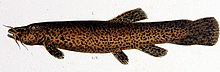
Trichomycterus rivulatus is a species of pencil catfish that is native to high-altitude Andean streams and lakes (including Junin, Poopó and Titicaca) in southern Peru, western Bolivia and northern Chile. It is the largest species in the genus Trichomycterus and grows to a maximum length of 37.4 centimetres (14.7 in) TL. The species is regularly caught as a food fish. However, because of pollution, studies have revealed levels of metals in T. rivulatus of Lake Titicaca that exceed the internationally recommended safety thresholds for human consumption. (Full article...) -
Yerupaja Chico is a mountain in Peru.
Yerupaja Chicho rises 6,121 metres (20,082 ft) and neighboring Yerupaja rises 6,617 metres (21,709 ft). The names' literal translations are yerupaja – smaller and yerupaja – larger. They are two peaks in the Peruvian Andes. They can be viewed from above Laguna Solteracocha on the way up to Punta Sambuya on trekking trails through the Huayhuash. Chico is claimed to be a technically more difficult project for mountain climbers, although it is approximately 600 metres lower. (Full article...) -
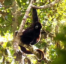
The yellow-tailed woolly monkey (Lagothrix flavicauda) is a New World monkey endemic to Peru. It is a rare primate species found only in the Peruvian Andes, in the departments of Amazonas and San Martin, as well as bordering areas of La Libertad, Huánuco, and Loreto. (Full article...) -
Laram Q'awa (Aymara larama blue, q'awa little river, ditch, crevice, fissure, gap in the earth, "blue brook" or "blue ravine", Hispanicized spellings Laram Khaua, Larancagua) is a 5,182-metre-high (17,001 ft) mountain in the Andes. According to the Bolivian IGM map 1:50,000 'Nevados Payachata Hoja 5739-I' it is situated on Bolivian terrain in the La Paz Department, Pacajes Province (Charaña Municipality), at the border with Chile. It lies north-west of the mountains Kunturiri, Phaq'u Q'awa and another mountain on the border named Laram Q'awa (Laram Khaua). One of three different rivers of this area called Kunturiri (Condoriri) originates north-east of the mountain near Phaq'u Q'awa. It flows in a bow along the northern slopes of Laram Q'awa towards Chile. (Full article...) -
Salcantay, Salkantay or Sallqantay (in Quechua) is the highest peak in the Vilcabamba mountain range, part of the Peruvian Andes. It is located in the Cusco Region, about 60 km (40 mi) west-northwest of the city of Cusco. It is the 38th-highest peak in the Andes and the twelfth-highest in Peru. However, as a range highpoint in deeply incised terrain, it is the second most topographically prominent peak in the country, after Huascarán.
Salcantay's proximity to Machu Picchu makes trekking around it an alternative to the oversubscribed Inca Trail; this is known as the Salkantay trek. (Full article...) -
Ancohuma or Janq'u Uma (Aymara janq'u white, uma water, "white water", also spelled Janq'uma, other spellings, Jankho Uma, Jankhouma) is the third highest mountain in Bolivia (after Sajama and Illimani). It is located in the northern section of the Cordillera Real, part of the Andes, east of Lake Titicaca. It lies just south of the slightly lower Illampu, near the town of Sorata.
Despite being higher than Illampu, Ancohuma is a gentler peak, with less local relief, and it is a somewhat easier climb. The peak was first climbed in 1919, by Rudolf Dienst and Adolf Schulze. Their route, still the easiest, climbs the southwest face, and is rated PD (not very difficult). Other routes exist on the northwest ridge and the west face. Depending on the route desired, the mountain is approached either from the west or from the northeast; each approach requires two to three days from Sorata. (Full article...) -

Lake Junin (IPA: [xuˈnin]; Spanish Lago Junín, named after the nearby town of Junin) or Chinchaycocha (possibly from Quechua chincha, chinchay north, northern, chinchay ocelot, qucha lake, lagoon, "northern lake" or "ocelot lake") is the largest lake entirely within Peruvian territory. Even though Lake Titicaca has a much larger area, its eastern half is located on Bolivian territory. Lake Junin is an important birdwatching destination in the country. (Full article...) -
Cerro Galán is a caldera in the Catamarca Province of Argentina. It is one of the largest exposed calderas in the world and forms part of the Central Volcanic Zone of the Andes, one of the three volcanic belts found in South America. One of several major caldera systems in the Central Volcanic Zone, the mountain is grouped into the Altiplano–Puna volcanic complex.
Volcanic activity at Galán is the indirect consequence of the subduction of the Nazca Plate beneath the South America Plate, and involves the infiltration of melts into the crust and the formation of secondary magmas which after storage in the crust give rise to the dacitic to rhyodacitic rocks erupted by the volcano. (Full article...) -
Licancabur (Spanish pronunciation: [likaŋkaˈβuɾ]) is a stratovolcano on the border between Bolivia and Chile, south of the Sairecabur volcano and west of Juriques. Part of the Andean Central Volcanic Zone, it has a prominent, 5,916-metre (19,409 ft)-high cone. A 400–500-metre (1,300–1,600 ft) summit crater containing Licancabur Lake, a crater lake which is among the highest lakes in the world, caps the volcano. There are no glaciers owing to the arid climate. Numerous animal species and plants live on the mountain.
Licancabur formed atop of Pleistocene ignimbrites and has been active during the Holocene, after the ice ages. Three stages of lava flows emanate from the edifice and have a young appearance. Although no historic eruptions of the volcano are known, lava flows extending into Laguna Verde have been dated to 13,240 ± 100 BP and there may be residual heat in the mountain. The volcano has primarily erupted andesite, with small amounts of dacite and basaltic andesite. (Full article...) -
Acamarachi (also known as Pili) is a 6,046-metre (19,836 ft) high volcano in northern Chile. In this part of Chile, it is the highest volcano. Its name means "black moon". It is a volcano in the Central Volcanic Zone of the Andes, a zone of strong volcanic activity during the last million years. Old volcanoes in the area are well-preserved, due to the dry climate.
Acamarachi itself is a cone-shaped volcano with steep upper flanks and a lava dome on its northern side. While there is no indication of historical activity and the flank lava flows are old, some lava flows around the summit crater and a lava coulee north of Acamarachi on the saddle between Acamarachi and Colachi volcano may be postglacial in age. Acamarachi is formed by andesitic and dacitic rocks. (Full article...) -
Artesonraju is a pyramidal mountain peak located near the city of Caraz in the Cordillera Blanca mountain range in the Peruvian Andes. It is located at the Peruvian province of Huaylas and its slopes are within two cities: Santa Cruz and Caraz. Its summit has an elevation of 6,025 metres (19,767 ft) (or 5,999 metres (19,682 ft) according to the IGN-Peru map). It is one of many prominent peaks (2772 metres) located within the boundaries of Peru's Huascarán National Park.
Artesonraju has two distinguished climbing routes. Due to their difficulties, Artesonraju is seldom successfully climbed in comparison to other well known mountains in the Cordillera Blanca. This mountain was said to be the inspiration for the current production logo for Paramount Pictures; it is now believed to be Ben Lomond, a mountain in Utah. (Full article...) -
The Illinizas are a pair of volcanic mountains that are located in the north of Latacunga, Cotopaxi, Ecuador. They are located in the Illinizas Ecological Reserve (Spanish: Reserva Ecológica Los Illinizas). These twin mountains are separated by a saddle that is about a kilometer long. The peaks are among the highest in Ecuador, with Illiniza Sur standing slightly taller than Illiniza Norte, its northern counterpart, at 5245 metres and 5126 metres respectively.
Most guidebooks (for example, Lonely Planet Ecuador, Ecuador: A Climbing Guide) spell the mountain with only one "l" as in Iliniza. The name Illinizas is derived from the Kunza words for "masculine hill." (Full article...) -
Tupungato, one of the highest mountains in the Americas, is a massive Andean lava dome dating to Pleistocene times. It lies on the Argentina–Chile border, between the Chilean Metropolitan Region (near a major international highway about 80 km (50 mi) east of Santiago) and the Argentine province of Mendoza, about 100 km (62 mi) south of Aconcagua, the highest peak of both the Southern and Western hemispheres. Immediately to its southwest is the active Tupungatito volcano (literally, little Tupungato), which last erupted in 1987.
Tupungato Department, an important Argentine wine-producing region in Mendoza province, is named for the volcano. Recent Chilean mapping indicates it has a height of 6635m. (Full article...)


_male_Antioquia.jpg)


Did you know...
- ... that the 1930s Polish Andean expeditions have been credited with several first ascents and the tracing of a new route to the summit of Aconcagua, the Andes' highest peak?
Need help?
Do you have a question about Andes that you can't find the answer to?
Consider asking it at the Wikipedia reference desk.
Selected images
-
 Bolivian Andes (from Andes)
 -

-
 Pico Humboldt at sunset (from Andes)
 -
 Parinacota, Bolivia/Chile (from Andes)
 -

-
 Central Andes (from Andes)
 -
 Nevado del Huila, Colombia (from Andes)
 -
 Frederic Edwin Church, Heart of the Andes, 1859. (from Andes)
 -

-

-
 View of Cuernos del Paine in Torres del Paine National Park, Chile (from Andes)
 -
 Aerial view of Valle Carbajal in the Tierra del Fuego. The Andes range is about 200 km (124 mi) wide throughout its length, except in the Bolivian flexure where it is about 640 kilometres (398 mi) wide. (from Andes)
 -
 Laguna de Sonso tropical dry forest in Northern Andes (from Andes)
 -
 Peruvian farmers sowing maize and beans (from Andes)
 -

-

-

-
 Irrigating land in the Peruvian Andes (from Andes)
 -

-

-
 A male Andean cock-of-the-rock, a species found in humid Andean forests and the national bird of Peru (from Andes)
 -

-


.jpg)


%E2%80%93Valle_Carbajal_01.jpg)


.jpg)
.jpg)
Subcategories

- Select [►] to view subcategories
Subtopics
Associated Wikimedia
The following Wikimedia Foundation sister projects provide more on this subject:
-
 Commons
Free media repository -
 Wikibooks
Free textbooks and manuals -
 Wikidata
Free knowledge base -
 Wikinews
Free-content news -
 Wikiquote
Collection of quotations -
 Wikisource
Free-content library -
 Wikiversity
Free learning tools -
 Wiktionary
Dictionary and thesaurus
-->