Wikipedia:Graphics Lab/Map workshop/Archive/Oct 2021
| This page is an archive. Do not edit the contents of this page. Please direct any additional comments to the current main page. |

German destroyer Z39 service map

- Article(s)
- German destroyer Z39
- Request
Hello, I'm currently attempting to get German destroyer Z39 through FAC; a reviewer has suggested a map of the locations it served, for ease of understanding positions relative to each other; if anyone would be willing to put together a map wth the various operations of Z39, I would very much appreciate it. Iazyges Consermonor Opus meum 07:30, 12 September 2021 (UTC)
- Iazyges, would you mind providing the locations? — Berrely • Talk∕Contribs 09:05, 12 September 2021 (UTC)
- @Berrely: Sure thing; I've also included dates if you want to add them. She was laid down in Kiel, Germany 15 August 1940, stayed there until commissioned 21 August 1943; lays mines in Skagerrak and Kattegat until March 1944, moved to Reval (Estonia) in March 1944; 11 and 12 March 1944 naval bombarded near Narva-Jõesuu (Estonia). 13 to 14 April 1944 laid mines south of Suur Tytärsaari (Finland). 16 to 17 April 1944 laid mines of Vigrund Island in Narva Bay (Estonia). 23 to 24 April 1944 laid mines in Narva Bay. 25 to 26 April 1944 laid mines southwest of Suur Tyärsaari. 23 1944 June bombed while in port in Paldiski (Estonia), travels to Libau from 23 to 29 June; 24 July hit by bomb in Kiel harbor. 28 February 1945 leaves Kiel, heads to Sassnitz (Germany). 5 to 7 April escorts in Bay of Danzig (Poland/Germany). 10 April escorts ships to Warnemünde and Swinemünde. 15 April 1945 escorts ships to Copenhagen. 2 May shells Soviet troops near Oder estuary. 3 May defends bridge on Peene river near Wolgast; 4 May escorts ships to Copenhagen. 8 to 9 May 1945 escorts ships from Hela to Glücksburg. 10 May 1945 decommissioned at Kiel. Iazyges Consermonor Opus meum 09:25, 12 September 2021 (UTC)
- @Iazyges I might have a go. Would you like it on a topographic map (hillshading) or a political map? — Berrely • Talk∕Contribs 17:36, 13 September 2021 (UTC)
- File:BLANK in Europe (relief) (-mini map).svg this is what I'd probably use — Berrely • Talk∕Contribs 17:42, 13 September 2021 (UTC)
- Given that political borders changed enormously during the period she served, I'd suggest using the topographical map you provided. Iazyges Consermonor Opus meum 18:31, 13 September 2021 (UTC)
- @Berrely: Realized I didn't ping you before with my response, any interest in completing this? Iazyges Consermonor Opus meum 17:54, 26 September 2021 (UTC)
- Given that political borders changed enormously during the period she served, I'd suggest using the topographical map you provided. Iazyges Consermonor Opus meum 18:31, 13 September 2021 (UTC)
- File:BLANK in Europe (relief) (-mini map).svg this is what I'd probably use — Berrely • Talk∕Contribs 17:42, 13 September 2021 (UTC)
- @Iazyges I might have a go. Would you like it on a topographic map (hillshading) or a political map? — Berrely • Talk∕Contribs 17:36, 13 September 2021 (UTC)
- @Berrely: Sure thing; I've also included dates if you want to add them. She was laid down in Kiel, Germany 15 August 1940, stayed there until commissioned 21 August 1943; lays mines in Skagerrak and Kattegat until March 1944, moved to Reval (Estonia) in March 1944; 11 and 12 March 1944 naval bombarded near Narva-Jõesuu (Estonia). 13 to 14 April 1944 laid mines south of Suur Tytärsaari (Finland). 16 to 17 April 1944 laid mines of Vigrund Island in Narva Bay (Estonia). 23 to 24 April 1944 laid mines in Narva Bay. 25 to 26 April 1944 laid mines southwest of Suur Tyärsaari. 23 1944 June bombed while in port in Paldiski (Estonia), travels to Libau from 23 to 29 June; 24 July hit by bomb in Kiel harbor. 28 February 1945 leaves Kiel, heads to Sassnitz (Germany). 5 to 7 April escorts in Bay of Danzig (Poland/Germany). 10 April escorts ships to Warnemünde and Swinemünde. 15 April 1945 escorts ships to Copenhagen. 2 May shells Soviet troops near Oder estuary. 3 May defends bridge on Peene river near Wolgast; 4 May escorts ships to Copenhagen. 8 to 9 May 1945 escorts ships from Hela to Glücksburg. 10 May 1945 decommissioned at Kiel. Iazyges Consermonor Opus meum 09:25, 12 September 2021 (UTC)
Iazyges I'll try tomorrow, sorry for that wait — Berrely • Talk∕Contribs 18:00, 26 September 2021 (UTC)
- No problem whatsoever. Iazyges Consermonor Opus meum 23:40, 26 September 2021 (UTC)
- Hello Iazyges, I am very very sorry for getting back so late. Here is a rough draft [1]. Would it be better to zoom in to Northern Europe? Do you want me to move anything, make corrections, etc? — Berrely • Talk∕Contribs 18:21, 29 September 2021 (UTC)
- this is what it looks like slightly zoomed in. I might play around with some of the lines to give them better placement. — Berrely • Talk∕Contribs 18:22, 29 September 2021 (UTC)
- @Berrely: No problem! It looks good mostly, although the "Oder" point should be moved to the end of the Oder Estuary, near Stettin File:Oder.png, otherwise it looks great! I think the zoomed out version looks best. Iazyges Consermonor Opus meum 18:25, 29 September 2021 (UTC)
- @Iazyges is this better? Or do you want the pointer to be more north? — Berrely • Talk∕Contribs 18:30, 29 September 2021 (UTC)
- @Berrely: It should probably be just to the south-east of Swinoujscie. Iazyges Consermonor Opus meum 18:33, 29 September 2021 (UTC)
- @Iazyges like this? (apologies if it's very obvious I'm a bit confused as to where the river's centre actually is). If this might help, 1, 2 or 3? — Berrely • Talk∕Contribs 18:37, 29 September 2021 (UTC)
- @Berrely: 1 should be best; we aren't perfectly clear on where exactly Z39 was in the Estuary, but she probably wouldn't be able to go further in than 1 without being beached. Iazyges Consermonor Opus meum 18:41, 29 September 2021 (UTC)
- @Iazyges Ok, I think I've got it (hopefully) — Berrely • Talk∕Contribs 18:46, 29 September 2021 (UTC)
- @Berrely: Looks great! Iazyges Consermonor Opus meum 18:47, 29 September 2021 (UTC)
- Alright, the map so far is at File:German destroyer Z39 map.svg. I am aware there is some transparency around the borders but I have to pop out now, and I'll try to fix it tomorrow. Sorry :( — Berrely • Talk∕Contribs 18:57, 29 September 2021 (UTC)
- @Berrely: Looks great! Iazyges Consermonor Opus meum 18:47, 29 September 2021 (UTC)
- @Iazyges Ok, I think I've got it (hopefully) — Berrely • Talk∕Contribs 18:46, 29 September 2021 (UTC)
- @Berrely: 1 should be best; we aren't perfectly clear on where exactly Z39 was in the Estuary, but she probably wouldn't be able to go further in than 1 without being beached. Iazyges Consermonor Opus meum 18:41, 29 September 2021 (UTC)
- @Iazyges like this? (apologies if it's very obvious I'm a bit confused as to where the river's centre actually is). If this might help, 1, 2 or 3? — Berrely • Talk∕Contribs 18:37, 29 September 2021 (UTC)
- @Berrely: It should probably be just to the south-east of Swinoujscie. Iazyges Consermonor Opus meum 18:33, 29 September 2021 (UTC)
- @Iazyges is this better? Or do you want the pointer to be more north? — Berrely • Talk∕Contribs 18:30, 29 September 2021 (UTC)
- @Berrely: No problem! It looks good mostly, although the "Oder" point should be moved to the end of the Oder Estuary, near Stettin File:Oder.png, otherwise it looks great! I think the zoomed out version looks best. Iazyges Consermonor Opus meum 18:25, 29 September 2021 (UTC)
- this is what it looks like slightly zoomed in. I might play around with some of the lines to give them better placement. — Berrely • Talk∕Contribs 18:22, 29 September 2021 (UTC)
- Hello Iazyges, I am very very sorry for getting back so late. Here is a rough draft [1]. Would it be better to zoom in to Northern Europe? Do you want me to move anything, make corrections, etc? — Berrely • Talk∕Contribs 18:21, 29 September 2021 (UTC)
@Iazyges, I seem to have fixed it. Is there anything else you need on the map? — Berrely • Talk∕Contribs 09:31, 9 October 2021 (UTC)
- @Berrely: Nope, that's great! Thank you! Iazyges Consermonor Opus meum 15:57, 9 October 2021 (UTC)
ECAA maps
-
 map
map -
 map 2
map 2


- Article(s)
- European Common Aviation Area
- Request
- Ukraine has just joined the ECAA on today's EU–Ukraine summit, both maps need to be recolored accordingly to reflect that fact: https://www.kyivpost.com/ukraine-politics/ukraine-just-signed-an-open-skies-treaty-with-the-eu-what-is-it.html -- Fixmaster (talk) 17:44, 12 October 2021 (UTC)
Request
- Article(s)
- 2017 United States Electoral College vote count
- Request
- I would really appreciate it if one of you wonderful experts could make a map similar to this one...
https://upload.wikimedia.org/wikipedia/commons/2/22/2021_US_Electoral_College_objections_map.svg
....except for different colors for different states. I would like to see a map where most of the states are green (#A9FAAD), but all of the following states are yellow (#FFE4E4) - Alabama, Florida, Georgia, Michigan, Mississippi, North Carolina, South Carolina, West Virginia, Wisconsin, Wyoming.
Capisred (talk) 23:56, 16 November 2021 (UTC) -- Capisred (talk) 04:52, 17 November 2021 (UTC)
- Discussion
- @Capisred: please see File:ElectoralCollege2016.svg and Template:2016 United States presidential election imagemap --Guerillero Parlez Moi 12:07, 17 November 2021 (UTC)
- I didn't get what you were asking for. Here you go

map - -- Guerillero Parlez Moi 14:31, 17 November 2021 (UTC)

{{resolved}} --Guerillero Parlez Moi 12:33, 30 November 2021 (UTC)
Istanbul Convention
-
 map
map -
 map 2
map 2


_(-mini_map).svg)
![[1]](https://i.imgur.com/VkXhflG.jpeg)
- Article(s)
- Istanbul Convention
- Request
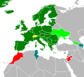
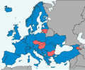
- On Map 2, there's no color for former parties, Turkey needs to get red as a former party. Liechtenstein and Moldova both have ratified it and thus need to get blue.
On the first map, Moldova should get green because it has ratified the convention. Fixmaster (talk) 18:24, 22 October 2021 (UTC)
Possible to tweak a map for Battle of St. Charles
{{resolved}} As noted at Wikipedia:Featured article candidates/Battle of St. Charles/archive1, File:Saint Charles Battlefield Arkansas.jpg has MOS:COLOR issues. It was suggested that it might be possible to fix some of the insufficient contrast issues here. Thanks in advance. Hog Farm Talk 05:31, 24 November 2021 (UTC)
- What colors are you thinking, Hog Farm? Are there any critically important parts of the basemap? Guerillero Parlez Moi 12:34, 30 November 2021 (UTC)
- @Guerillero: - Sorry, I thought I responded to this several days ago. The only really important part is the yellow/green shading overlaid on the map (can be different colors), the location of the main river, and the location of St. Charles townsite. Additional maps of the area can be found at [2], if that helps. Hog Farm Talk 05:30, 3 December 2021 (UTC)