Wikipedia:Graphics Lab/Map workshop/Archive/Jun 2021
| This page is an archive. Do not edit the contents of this page. Please direct any additional comments to the current main page. |

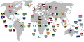
Independence from Britain
-
-
 Actual flag of Dominica
 -
 Current flag of Belize
 -
 Pacific islands map
 -
 Caribbean countries map


- Article(s)
- List of countries that have gained independence from the United Kingdom
- Request
- Okay, I've noticed a few inaccuracies with the above-left map that should probably be fixed:
1) The flag of the Dominican Republic is incorrectly shown for Dominica (above), a completely different country.
2) Saint Vincent and the Grenadines gained independence in 1979, not 1931.
3) There's no arrows linking the flags of the Maldives, Myanmar and Sudan to their respective countries.
4) The flag of Malta is wrongly shown to be linked to the Balearic Islands, not at Malta itself.
5) Nauru gained independence in 1968, not 1957.
6) The Maldives gained independence in 1965, not 1982.
7) The flags of Tonga and Tuvalu are actually shown pointing to Fiji, and the flag of Fiji itself is linked to Vanuatu (the actual locations of said countries are provided on the above-right map).
8) The flag of Qatar is wrongly shown to be linked to the United Arab Emirates, not at Qatar itself.
9) The flag of Jordan seems to be pointing more at the West Bank than at Jordan itself.
10) The flag of Belize was slightly altered in 2019 (as shown above), so the one on the map should be changed to reflect that.
11) The flag of Mauritius is not pointing at Mauritius at all, but rather at a random spot in the Indian Ocean.
12) Papua New Guinea gained independence from Australia in 1975, not from Britain, hence it should be removed from the map (otherwise the map would have to include all other countries that gained independence from former British holdings, such as Samoa, Bangladesh, Namibia, South Sudan, etc.).
Thanks. Snow Lion Fenian (talk) 17:09, 28 June 2021 (UTC)
- Discussion
![]() Request taken by --always ping me-- Goran tek-en (talk) 16:00, 30 June 2021 (UTC).
Request taken by --always ping me-- Goran tek-en (talk) 16:00, 30 June 2021 (UTC).
- Snow Lion Fenian
- 1) Is not that arrow pointing to the wrong island?
- This draft is a PNG version of the original SVG file I'm working in and will upload to commons. Draft-1. --always ping me-- Goran tek-en (talk) 17:44, 30 June 2021 (UTC)
- @Goran tek-en: Thanks for taking this on. And now that you mention it, yes, some of the Caribbean nations flags are indeed pointing to the wrong islands. Hence I've now provided a map displaying the proper locations of the political divisions within the Caribbean above. Thanks for pointing that out. Snow Lion Fenian (talk) 12:52, 1 July 2021 (UTC)
- Snow Lion Fenian I don't know which countries the different flags are from so I don't know what to check/edit. If you could write names and links to wikipedia articles with flags it would be great, thanks. --always ping me-- Goran tek-en (talk) 16:52, 2 July 2021 (UTC)
- Snow Lion Fenian I need to now if you will provide the needed information, if not I will upload what I have edited and mark this Done? --always ping me-- Goran tek-en (talk) 11:09, 10 July 2021 (UTC)
- Snow Lion Fenian I don't know which countries the different flags are from so I don't know what to check/edit. If you could write names and links to wikipedia articles with flags it would be great, thanks. --always ping me-- Goran tek-en (talk) 16:52, 2 July 2021 (UTC)
- @Goran tek-en: Thanks for taking this on. And now that you mention it, yes, some of the Caribbean nations flags are indeed pointing to the wrong islands. Hence I've now provided a map displaying the proper locations of the political divisions within the Caribbean above. Thanks for pointing that out. Snow Lion Fenian (talk) 12:52, 1 July 2021 (UTC)
- @Goran tek-en: Sorry for not getting back to you sooner. Yes, here's a list of the things that need changing in the Caribbean:
- 1) The arrow for Antigua and Barbuda is pointing at a random spot in the Caribbean, not at Antigua and Barbuda itself.
- 2) The arrow for Trinidad and Tobago is pointing north-east of where the actual country is.
- 3) The arrow for Barbados should be pointing to the easternmost island in the Caribbean.
- 4) The arrow for Saint Vincent and the Grenadines should be pointing to the island straight to the west of Barbados.
- 5) The arrow for Saint Lucia should be pointing to the island above Saint Vincent and the Grenadines.
- 6) The arrow for Saint Kitts and Nevis is pointing at a random spot in the Caribbean, not at Saint Kitts and Nevis itself.
- 7) The arrow for Grenada should be pointing to the island located to the northwest of Trinidad and Tobago and southwest of Saint Vincent and the Grenadines.
- 8) The arrow for Dominica is pointing at a random spot in the Caribbean, not at Dominica itself.
- Hope it helps. Snow Lion Fenian (talk) 07:38, 11 July 2021 (UTC)
- Snow Lion Fenian Thanks, perfect info. Here is draft of that area for you to check. --always ping me-- Goran tek-en (talk) 17:00, 12 July 2021 (UTC)
- @Goran tek-en: Thanks for that! Most of them appear to be in order, great work. Although I notice that the arrow for Jamaica isn't pointing at the actual island of Jamaica? Snow Lion Fenian (talk) 08:54, 16 July 2021 (UTC)
- Snow Lion Fenian Thanks, perfect info. Here is draft of that area for you to check. --always ping me-- Goran tek-en (talk) 17:00, 12 July 2021 (UTC)
- Hope it helps. Snow Lion Fenian (talk) 07:38, 11 July 2021 (UTC)
Snow Lion Fenian Jamaica fixed. New version uploaded. If you are happy with this please put the code {{tl|resolved|1=~~~~}} on this request so it can be archived, thanks. ![]() Done --always ping me-- Goran tek-en (talk) 18:44, 16 July 2021 (UTC)
Done --always ping me-- Goran tek-en (talk) 18:44, 16 July 2021 (UTC)
Map of Maksimir Park
-
 Jpg map of the Park

- Article(s)
- Maksimir Park
- Request
- Hello could you make svg map of Maksimir Park. If you need any assistance or better resolution of photo send me a message -- Kaštel Stari (talk) 10:36, 21 July 2021 (UTC) -- Kaštel Stari (talk) 10:36, 21 July 2021 (UTC)
- Discussion
![]() Request taken by --always ping me-- Goran tek-en (talk) 18:13, 21 July 2021 (UTC).
Request taken by --always ping me-- Goran tek-en (talk) 18:13, 21 July 2021 (UTC).
Extended content
|
|---|
|
Kaštel Stari Yes I would need a better image. Also how do you want the map to look, similar to your source or what? Could you also send me a link for its location on OSM, thanks. --always ping me-- Goran tek-en (talk) 18:13, 21 July 2021 (UTC)
Goran tek-en I overwrote the file above. — Berrely • Talk∕Contribs 17:10, 22 July 2021 (UTC)
Kaštel Stari (talk) 20:31, 23 July 2021 (UTC)
Kaštel Stari Thanks, it's really helpful. Two new drafts.
Kaštel Stari (talk) 14:26, 2 August 2021 (UTC) |
Kaštel Stari I don't understand what you want me to do with the title text, I copied yours, you could see the draft?
- Now you can find it here Commons:file:Situacijski plan Parka Jurjaves (Maksimir) 1846.svg.
![]() Done
Done
- Did you want a map of how it looks today from OSM? If you do, you can wait with the code below, please ping me so I know, thanks.
If you are happy with this please put the code "{{tl|resolved|1=~~~~}}" on this request so it can be archived, thanks. --always ping me-- Goran tek-en (talk) 13:03, 3 August 2021 (UTC)
- Goran tek-en Yes, I would like a map of how it looks today. Kaštel Stari (talk) 14:06, 3 August 2021 (UTC)
- Kaštel Stari Do you know of any reference points from 1846 and today which are the same? It's very hard to position the today map correct. --always ping me-- Goran tek-en (talk) 15:56, 3 August 2021 (UTC)
- Kaštel Stari Never mind I think I found them. --always ping me-- Goran tek-en (talk) 16:12, 3 August 2021 (UTC)
- Goran tek-en No, these two maps are separate. Just make today map and don’t bother with reference points. Kaštel Stari (talk) 17:25, 3 August 2021 (UTC)
- Kaštel Stari Yes I know bot don't you think that it would be nice to be able to compare them at some time? --always ping me-- Goran tek-en (talk) 18:29, 3 August 2021 (UTC)
- Goran tek-en Well, yes sure! You can then make one map where it is side by side with one from 1846, and the secound one which is alone? Kaštel Stari (talk) 19:53, 3 August 2021 (UTC)
- Goran tek-en No, these two maps are separate. Just make today map and don’t bother with reference points. Kaštel Stari (talk) 17:25, 3 August 2021 (UTC)
- Kaštel Stari Never mind I think I found them. --always ping me-- Goran tek-en (talk) 16:12, 3 August 2021 (UTC)
- Kaštel Stari Do you know of any reference points from 1846 and today which are the same? It's very hard to position the today map correct. --always ping me-- Goran tek-en (talk) 15:56, 3 August 2021 (UTC)
Request: Adjusting combined British and Mongol Empire map
-
 A map of the British (red) and Mongol (blue) empires at their respective greatest extents

- Article(s)
- List of largest empires
- Request
- Hello! This map has been used at List of largest empires until Kimand299 noted that
The mongol empire never went that far into eastern europe even at its greatest extent
and removed it. I think that this would be fixed if the map used the European border from this version of the Mongol Empire map instead of this version, but I'm not entirely sure so Kimand299 may have to correct me on that. We also noted that it's rather difficult to tell that Hong Kong was part of the British Empire without zooming in quite closely, which I'm not sure how best to solve (it is rather a small territory, so maybe it's okay that zooming in to see it is necessary?). There may be other issues that Kimand299 have noticed—I'll let them elaborate on that if that's the case.
Pinging Amitchell125 who created the map. TompaDompa (talk) 00:22, 1 May 2021 (UTC)
- Discussion
-
- I've contacted Kimand299 to ask for any useful comments before proceeding to offer to amend the map. Amitchell125 (talk) 10:57, 6 May 2021 (UTC)
- The farthest the Mongol empire went was just short of the Balkans, eastern europe was just vassal states. Kimand299 (talk) 08:43, 28 May 2021 (UTC)
- Amitchell125, what do you think? TompaDompa (talk) 19:11, 20 June 2021 (UTC)
- The farthest the Mongol empire went was just short of the Balkans, eastern europe was just vassal states. Kimand299 (talk) 08:43, 28 May 2021 (UTC)
- I've contacted Kimand299 to ask for any useful comments before proceeding to offer to amend the map. Amitchell125 (talk) 10:57, 6 May 2021 (UTC)
Request: Map of Auckland, New Zealand
-
 Map of Auckland Region
 -
 Auckland Wards
 -
 Map of Pennsylvania


_1846.svg)
- Article(s)
- 2021 New Zealand National League
- 2021 New Zealand Women's National League
- Request
- Hello, I am looking to have a map of Auckland, similar in style to the one of London above. The map will be used in the articles listed above to show the locations of the Auckland teams (as well as for future seasons). So far I have only managed to find the one of Auckland shown above or another, which was a plain orange map of Auckland. They aren't quite what I was looking for though. If anyone could help that would be greatly appreciated. Cheers. -- Kezyfooty (talk) 11:35, 14 June 2021 (UTC)
- Discussion
- The thing with the London map is that it was made almost entirely using the free to use Ordnance Survey data. I'm sure there is a similar resource for Auckland, but I'm not sure if I can find something for the urban areas. — Berrely • Talk∕Contribs 17:10, 14 June 2021 (UTC)
- Ahhh right. Do you know if it is possible to have one like the Pennsylvania one above for the region of Auckland? Hope you can help. Thank you for your time. Cheers -- Kezyfooty (talk) 05:21, 15 June 2021 (UTC)
- @Kezyfooty sorry for getting back a bit late; do you have a specific boundary in Auckland you would like to highlight? I personally have no experience with how electoral divisions in New Zealand work and don't know what you want to be highlighted. — Berrely • Talk∕Contribs 20:51, 19 June 2021 (UTC)
- Hi Berrely, no worries. I would be looking to have the Auckland Region being the highlighted region/area of the map. In terms of the divisions, I would be looking to have the wards of Auckland Council as shown by the image above. Cheers -- Kezyfooty (talk) 00:57, 20 June 2021 (UTC)
- @Kezyfooty sorry for getting back a bit late; do you have a specific boundary in Auckland you would like to highlight? I personally have no experience with how electoral divisions in New Zealand work and don't know what you want to be highlighted. — Berrely • Talk∕Contribs 20:51, 19 June 2021 (UTC)
- Ahhh right. Do you know if it is possible to have one like the Pennsylvania one above for the region of Auckland? Hope you can help. Thank you for your time. Cheers -- Kezyfooty (talk) 05:21, 15 June 2021 (UTC)
Request: World map of nations who ban Muslim Brotherhood
{{resolved}}
- Article(s)
- Muslim Brotherhood
- Request
- Hi i am just wondering can sombody make a world map showing which nations Ban and list the Muslim Brotherhood as a terrorist organization. these are the nation which do it. thanks.La lopi (talk) 12:49, 30 July 2021 (UTC)
- Russia – 12 February 2003
- Kazakhstan –15 March 2005
- Tajikistan – 30 March 2006
- Syria – 21 October 2013
- Egypt – 25 December 2013
- Saudi Arabia – 7 March 2014
- Bahrain – 21 March 2014
- United Arab Emirates – 15 November 2014
- Discussion
- La lopi would you mind providing a source for this? I'm not comfortable with making a map on a highly contentious topic like this without a source. — Berrely • Talk∕Contribs 17:05, 1 August 2021 (UTC)
of course i can give a sources. here
- For Russia, https://web.archive.org/web/20160101081242/http://base.consultant.ru/cons/cgi/online.cgi?req=doc%3Bbase%3DEXP%3Bn%3D257852
- For Kazakhstan, https://www.eng.cisatc.org/1289/134/160/206
- For Tajikistan, https://en.wikipedia.org/wiki/Muslim_Brotherhood#cite_note-301 and https://en.fergana.news/news/114369/
- For Syria, http://www.hurriyetdailynews.com/assad-says-factors-not-in-place-for-syria-peace-talks.aspx?pageID=238&nID=56611&NewsCatID=352 and https://alwafd.news/%D8%A3%D8%AE%D8%A8%D8%A7%D8%B1-%D9%88%D8%AA%D9%82%D8%A7%D8%B1%D9%8A%D8%B1/1059666-7-%D8%AF%D9%88%D9%84-%D8%A7%D8%B9%D8%AA%D8%A8%D8%B1%D8%AA-%D8%A7%D9%84%D8%A5%D8%AE%D9%88%D8%A7%D9%86-%C2%AB%D8%AC%D9%85%D8%A7%D8%B9%D8%A9-%D8%A5%D8%B1%D9%87%D8%A7%D8%A8%D9%8A%D8%A9%C2%BB
- For Egypt, https://www.reuters.com/article/us-egypt-explosion-brotherhood-idUSBRE9BO08H20131225 and http://edition.cnn.com/2013/12/25/world/africa/egypt-muslim-brotherhood-terrorism/
- For Saudi Arabia, http://english.alarabiya.net/en/News/middle-east/2014/03/07/Saudi-Arabia-declares-Muslim-Brotherhood-terrorist-group.html
- For Bahrain, http://www.bna.bh/portal/en/news/609752 and http://aa.com.tr/en/archive/bahrain-fm-reiterates-stance-on-muslim-brotherhood/172889
- For United Arab Emirates, https://www.bloomberg.com/news/2014-03-09/u-a-e-supports-saudi-arabia-against-qatar-backed-brotherhood.html
Hope this helps. La lopi (talk) 04:21, 2 August 2021 (UTC) Thanks for doing the Map, just giving you a heads up you putted wrongly ukraine instead of Tajikistan. everything else is good. La lopi (talk) 14:59, 6 August 2021 (UTC)
References
Thanks for the clean up. just wondering i can't put thee map on the Muslim Brotherhood page becouse it says its Extended confirmed protection. just wondering can you put the map on the page thanks again. La lopi (talk) 09:32, 8 August 2021 (UTC)
- La lopi Done :) I added it to the "Foreign relations" section. — Berrely • Talk∕Contribs 10:51, 8 August 2021 (UTC)
Thank you for doing it.La lopi (talk) 14:26, 8 August 2021 (UTC)
Request to create Rohtak.svg

-
Description of first image
-
Description of second image (if needed)
-
Description of third image (if needed; don't request too many at once, though)
- Article(s)
- [[]]
- Request
- Details of your request go here… I request to create Rohtak.svg district map of Haryana State.-- I love to be honest (talk) 07:40, 27 June 2021 (UTC)
- Discussion
- @HariSinghw, can you please be a bit more specific? Do you want a locator map of Haryana, or one for Rohtak? — Berrely • Talk∕Contribs 12:51, 27 June 2021 (UTC)
- One for Rohtak District is requested in details and on top corner haryana state may be shown in Rohtak detailed map. I love to be honest (talk) 13:16, 27 June 2021 (UTC)
- @HariSinghw do you want the county or region boundary? — Berrely • Talk∕Contribs 13:23, 27 June 2021 (UTC)
- Nevermind File:India - Haryana - Rohtak.svg already exists. — Berrely • Talk∕Contribs 13:32, 27 June 2021 (UTC)
- File:India - Haryana - Rohtak.svg It is in Haryana I am requesting Rohtak specific svg file. I explain her In India there is state haryana and Rohtak is District. I am asking for Rohtak District only. I love to be honest (talk) 13:37, 27 June 2021 (UTC)
- Nevermind File:India - Haryana - Rohtak.svg already exists. — Berrely • Talk∕Contribs 13:32, 27 June 2021 (UTC)
- @HariSinghw do you want the county or region boundary? — Berrely • Talk∕Contribs 13:23, 27 June 2021 (UTC)