Wikipedia:Graphics Lab/Map workshop/Archive/Jun 2014
| This page is an archive. Do not edit the contents of this page. Please direct any additional comments to the current main page. |

Location map for Telangana, India
Article(s): Telangana, Hyderabad, several others
Request:
- Please create a location map image of Telangana, similar to Andhra Pradesh's File:Location map India Andhra Pradesh.png (though it should be an SVG, not a PNG). -- Jackmcbarn (talk) 18:35, 21 April 2014 (UTC)
Graphist opinion(s):
On the UN Ukraine vote map for Europe, Greenland should appear green (like Denmark) not grey
-
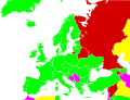 United Nations General Assembly resolution 68-262 vote in Europe

Article(s): United Nations General Assembly Resolution 68/262
Request:
- Summary: On the above map, please change the colour of Greenland from grey to green (the same colour as Denmark and the rest of Western Europe).
- Details: I've already posted a detailed justification for this request on the article's Talk Page, in this section. To avoid duplication, I haven't copied it to here, but please feel free to do so if you think that would help. Tlhslobus (talk) 03:19, 30 April 2014 (UTC)
Graphist opinion(s):
Location Map for Kolkata

Article: Multiple (to be used on articles related to Kolkata Please create a location map for Kolkata like File:Location_map_India_New_Delhi.png. You can use this File:Kolkata_Street_Map1.svg and Google map snapshot as a reference point, which is a bit outdated and does not incorporate areas like New Town, Kolkata and Belgharia Expressway. Amartyabag TALK2ME 07:09, 30 May 2014 (UTC)
 Request taken. Philg88 ♦talk 13:03, 30 May 2014 (UTC)
- Update This is in progress but there is an issue with changes to the Template namespace that I am trying to resolve. Watch this space! Philg88 ♦talk 14:17, 3 June 2014 (UTC)
- you should be able to just copy Template:Location map India Delhi to Template:Location map India Kolkata, and update it with the Kolkata image and border coordinates. Frietjes (talk) 14:39, 3 June 2014 (UTC)
- Thanks for the input Frietjes but that's not the way to do it. Use of Location Templates is now deprecated - they have to be created with Lua modules. I'm almost there in fact with the Lua stuff, just need to tweak the boundary coords. Philg88 ♦talk 16:33, 3 June 2014 (UTC)
- @Amartyabag:
 Done Example on the right is showing the new map with Fort William as an example. Philg88 ♦talk 08:13, 4 June 2014 (UTC)
- Thanks a lot for creating the location map. Amartyabag TALK2ME 09:47, 4 June 2014 (UTC)
- @Amartyabag:
- Thanks for the input Frietjes but that's not the way to do it. Use of Location Templates is now deprecated - they have to be created with Lua modules. I'm almost there in fact with the Lua stuff, just need to tweak the boundary coords. Philg88 ♦talk 16:33, 3 June 2014 (UTC)
- you should be able to just copy Template:Location map India Delhi to Template:Location map India Kolkata, and update it with the Kolkata image and border coordinates. Frietjes (talk) 14:39, 3 June 2014 (UTC)
- Update This is in progress but there is an issue with changes to the Template namespace that I am trying to resolve. Watch this space! Philg88 ♦talk 14:17, 3 June 2014 (UTC)
Agents of S.H.I.E.L.D. - Visited countries
Article(s): Agents of S.H.I.E.L.D.
Request:
- Could someone please use the blank map above to create a map highlighting in blue all the countries visited in the TV series Agents of S.H.I.E.L.D.. The countries you'd need to highlight are: The USA, Canada, Mexico, Peru, Cuba, the United Kingdom, Ireland, France, Spain, Italy, Switzerland, Norway, Sweden, Belarus, Malta, Russia, Georgia, China and Australia. — Preceding unsigned comment added by 5.134.90.140 (talk) 21:26, 30 May 2014 (UTC)
- Fallschirmjäger You have highlighted Georgia incorrectly, without Abkhazia and South Ossetia. They were recognized only by 6 countries total and currently only 4 countries recognize them. WP must reflect worldwide view so You should have highlighted Georgia in its internationally recognized boundaries. — Preceding unsigned comment added by UA Victory (talk • contribs) 09:03, 2 June 2014 (UTC)
Graphist opinion(s):
![]() Request taken. - Fallschirmjäger ✉ 12:23, 1 June 2014 (UTC)
Request taken. - Fallschirmjäger ✉ 12:23, 1 June 2014 (UTC)
- Done - Fallschirmjäger ✉ 13:01, 1 June 2014 (UTC)
- Apologies, yes I agree with your justification, I have now filled in Abkhazia and South Ossetia as part of Georgia. Kind regards, Fallschirmjäger ✉ 19:39, 2 June 2014 (UTC)
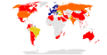
LTE (telecommunication)
-
 World Map of country activity

Article(s): LTE (telecommunication)
Request:
- Please change the colour of Colombia to red as it now offers commercial LTE in most of its departments.[1][2][3] or just update the whole map to match the following [4] -- pipeafcr (talk) 22:31, 15 April 2014 (EST)
Sri Lankan provinces location maps
Article(s): Sri Lankan settlement articles.

Request:
- Currently all location maps of Sri Lanka show the entire country. I would like to request individual location maps of Sri Lankan provinces, the first level administrative divisions of Sri Lanka, similar to File:USA California location map.svg, File:Australia New South Wales location map.svg. The only detail I require are boundaries of districts and DS divisions, the second and third level administrative divisions of Sri Lanka. A map showing the boundaries of districts and DS divisions is available here. There are nine provinces - if this is too many, could I request location maps for Northern Province and Eastern Province to start with. The maps will, if created, replace the countrywide location maps currently used on all Sri Lankan settlement articles. Thank you. -- obi2canibetalk contr 18:08, 5 June 2014 (UTC)
Graphist opinion(s):
- Comment That's an awful lot of work and involves quite a few maps. When you say locator maps, do you mean ones that use {{coord}} or ones where the individual districts/and DS divisions are highlighted? Philg88 ♦talk 18:26, 5 June 2014 (UTC)
@Obi2canibe: Here is a draft for Northern Province showing Jaffna via {{coord}}. I will wait for your comments before doing any others. Cheers, Philg88 ♦talk 06:37, 7 June 2014 (UTC)
- Thanks Phil, it's a great start. If I could make a few suggestions?
- Could the colour scheme be the same as File:USA California location map.svg?
- Could the gridlines, co-ordinates and ruler be removed?
- For the Northern Province map, could the map showing the location of the province within Sri Lanka be moved from bottom right to top right? This would reduce the amount of redundant space at the bottom of the map.
- --obi2canibetalk contr 13:08, 7 June 2014 (UTC)
- Thanks Phil, it's a great start. If I could make a few suggestions?
@Obi2canibe: Yes, yes and yes. Is that what you wanted? Cheers, Philg88 ♦talk 05:21, 8 June 2014 (UTC)
- Perfect, thank you. There's no rush to do the other provinces - as and when you have time.--obi2canibetalk contr 11:07, 8 June 2014 (UTC)
- You're welcome. I'll continue with the others over the next week or so. Philg88 ♦talk 16:04, 8 June 2014 (UTC)
- @Obi2canibe: I'm afraid I've hit a problem with the remainder of these maps. Outside of Northern Province, OpenStreetMap does not have any geocordinate data for the remaining provinces. I have tried to find alternative sources but have so far drawn a blank. If you know of any, please let me know otherwise this request will have to be closed. Philg88 ♦talk 13:12, 10 June 2014 (UTC)
- @Philg88: If you're referring to the fact that OSM doesn't have boundaries of other provinces, then the only open data map I could find which shows the boundaries is WikiMapia. But you have to zoom out to see the boundaries. It doesn't have the boundaries of districts. Is this of any use?--obi2canibetalk contr 19:29, 10 June 2014 (UTC)
- @Obi2canibe: I'm afraid I've hit a problem with the remainder of these maps. Outside of Northern Province, OpenStreetMap does not have any geocordinate data for the remaining provinces. I have tried to find alternative sources but have so far drawn a blank. If you know of any, please let me know otherwise this request will have to be closed. Philg88 ♦talk 13:12, 10 June 2014 (UTC)
- You're welcome. I'll continue with the others over the next week or so. Philg88 ♦talk 16:04, 8 June 2014 (UTC)
- Perfect, thank you. There's no rush to do the other provinces - as and when you have time.--obi2canibetalk contr 11:07, 8 June 2014 (UTC)
@Obi2canibe: While the boundaries are certainly shown on the WikiMapia map, the problem is that their data cannot be extracted/downloaded. Without exact coordinates it is impossible to map the boundaries accurately from a graphic alone. I'll keep looking and hopefully sooner or later someone will update the OSM map with the required data. Cheers, Philg88 ♦talk 05:39, 11 June 2014 (UTC)
- OK, thanks for your efforts.--obi2canibetalk contr 17:30, 11 June 2014 (UTC)
Andhra Pradesh

Article(s): Andhra Pradesh
Request: For making new map of the state after bifurcation, it should have a city or town locator svg map. Vin09 (talk) 19:10, 14 June 2014 (UTC)
Graphist opinion(s):
Pevensey Castle map
-
South-west quadrant of map
-
North-west quadrant of map
-
North-east quadrant of map
-
South-east quadrant of map
Article(s): Pevensey Castle
Request:
- This map was published over 60 years ago and is now in the public domain. The copy I have is still in good condition but is unfortunately a bit creased from being folded, as well as being much too big to scan in one go. I've therefore scanned it as four quadrants. Can someone stitch it together and do something about the fold lines on it? -- Prioryman (talk) 22:00, 17 June 2014 (UTC)
Graphist opinion(s):

![]() Done @Prioryman: Comments welcome. You might like to request speedy deletion of the scanned quadrants unless you want to retain them for some reason. Philg88 ♦talk 09:38, 18 June 2014 (UTC)
Done @Prioryman: Comments welcome. You might like to request speedy deletion of the scanned quadrants unless you want to retain them for some reason. Philg88 ♦talk 09:38, 18 June 2014 (UTC)
CERN Membership
-
 CERN Membership map.

Article(s): CERN
Request:
- Quick change: Please change the colors of Pakistan, Cyprus, Ukraine and Brazil to match that of Turkey. -- Fasi100 (talk) 07:37, 21 June 2014 (UTC)
Graphist opinion(s):
![]() Done—Love, Kelvinsong talk 19:27, 26 June 2014 (UTC)
Done—Love, Kelvinsong talk 19:27, 26 June 2014 (UTC)
Patriot League locations
-
 Location of Patriot league teams

Article(s): Patriot League
Request:
- The Patriot League added two new teams in 2013, expanding from the 8 listed on the graphic, to 10.
New Teams:
- Boston University at 42.3496, -71.0997
- Loyola University Maryland 39.346111, -76.618889
It would be nice if someone could update the graphic to reflect the new teams. (The original creator of isn't very active, or I would have asked that user.) -- S Philbrick(Talk) 16:25, 4 June 2014 (UTC)
Graphist opinion(s):
- Adding Loyola would be easy. But Boston isn't on that map, so it would involve starting again from the beginning. Maproom (talk) 11:28, 9 June 2014 (UTC)
- I'm not following your point. Boston isn't identified, but why can't one add a red dot near the location? It might mean moving the Holy Cross text to the left to avod overlap, but the red dot for Boston belongs just below and left of the "C" in Holy Cross.--S Philbrick(Talk) 13:09, 9 June 2014 (UTC)
Need improvement for a map in my sandbox before article creation
-
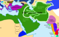 Movement of Abu Muslim's Abbasid loyalists against the Umayyad Empire

Article(s): User:MezzoMezzo/sandbox
Request:
- Currently, the Abbasid Revolution is just a redirect to the Umayyad Caliphate. I am working hard on turning the subsection in that article into a full fledged article in my sandbox. The problem is that the image looks a bit amateurish. Also, Umayyad is commonly spelled with a "U," not an "O." -- MezzoMezzo (talk) 11:36, 3 June 2014 (UTC)
- To be exact, could somebody just take this and then add the arrows and sphere of influence to it, but in a more professional-looking way? MezzoMezzo (talk) 11:11, 17 June 2014 (UTC)
- For any graphists interested in helping, the article has now been moved from my sandbox to main space at Abbasid Revolution. MezzoMezzo (talk) 05:43, 18 June 2014 (UTC)
- To be exact, could somebody just take this and then add the arrows and sphere of influence to it, but in a more professional-looking way? MezzoMezzo (talk) 11:11, 17 June 2014 (UTC)
Graphist opinion(s):
Pan-Mongolism map
-
 Map representing Pan-Mongolian claims
 -
 Yellow is the Zungharian Basin


Article(s): Pan-Mongolism
Request:
- add the Yellow region on the second map (Zungharian Basin) as a pink region on the first map. I have a source which shows that Pan-Mongolists included Dzungaria as part of their territory.
Note that we do not necesarily need to use the first map as a template, you can find another generic map of asia (Mongolia, China, and Russia), with the proper subdivisions, and start it over again. . -- Rajmaan (talk) 21:09, 10 June 2014 (UTC)
Graphist opinion(s):
DEA Field Divisions
-
 Map of DEA Field Divisions (outdated)
 -
 My attempt


Article(s): Drug Enforcement Administration
Request:
- The map linked above is out of date by a bit. A more modern, updated map is on the Justice Department's website. Both maps are PD-USGov, but both are of poor quality. I'm hoping one of you skilled volunteers can make a US map with the DEA divisions properly included from the Justice Department source. Thanks in advance for your consideration. TLSuda (talk) 21:04, 11 June 2014 (UTC)
Graphist opinion(s):
Rainbow Gathering#List_of_Gatherings
http://en.wikipedia.org/wiki/Rainbow_Gathering#List_of_Gatherings has 4 sections.
I'd particularly love to see a map of "United States Annual Rainbow Gatherings". The article lists the national forest (except for the first year - national park) and state of the gathering. A map would be a valuable addition. As would 4 - one map for each of the 4 sections. --76.216.6.136 (talk) 06:40, 27 June 2014 (UTC)
Metro New York City location map
-
 Existing NYC location map

Article(s): State University of New York
Request:
- I'd be interested in a similar map that also includes Westchester County, Rockland County, and the rest of Long Island, if that's not too difficult. The amount of detail that is shown on the existing NYC location map (roads, mainly) is not necessarily needed. And now that I think of it, perhaps the New Jersey and Connecticut areas of the tri-state area could be included in the 'lit' portion of the map, if the mapmaker sees fit. Thanks —Akrabbimtalk 20:00, 30 June 2014 (UTC)
Graphist opinion(s):