Wikipedia:Graphics Lab/Map workshop/Archive/Dec 2023
| This is an archive of past discussions for the period 2023. Do not edit the contents of this page. If you wish to start a new discussion or revive an old one, please do so on the current main page. |
 | Archives of 2023: January, February, March, April, May, June, July, August, September, October, November, December |
Corrections to Eurovision events maps
-
 Eurovision events map (template)
 -
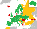 Eurovision Song Contest 2023 map (as example)
 -
 Eurovision Song Contest 1956 map (as example)
 -
 Example of how the map could look in future


- Article(s)
- Articles related to the Eurovision Song Contest, Junior Eurovision Song Contest and other European Broadcasting Union events
- Request
- A large number of maps have been produced over time for use on various articles related to the Eurovision Song Contest and other similar events (see Eurovision Song Contest 2023 for how these are used in practice and Commons:Category:SVG Maps of the Eurovision Song Contest for all SVG maps produced). However there are a number of discrepancies and errors with the current base file, with missing or incorrectly placed geographical features such as islands and lakes. Putting in a request for a new base file which corrects these errors and brings the maps more in line with other Europe maps on Wikipedia, which also keeping the specific features found on Eurovision maps, such as expanding the image frame to include north Africa and west Asia, enlarged microstates within their own frames.
- As the contest goes back to 1956, I am putting in a request that similar base files are also created which reflect the various border changes over time going back to May 1956, to include the Soviet Union and Yugoslavia prior to their dissolutions, but also reflecting border changes over time in the Middle East and the changes in overseas territories for European mainland countries. -- Sims2aholic8 (talk) 10:20, 1 December 2023 (UTC)
- Discussion
Correction of the error on the map

Can someone help? I drew this map with Adobe fresco on the phone. Please click for download PDF version. But since I forgot my password, I can't log in to my account and fix the error on the map. The only way to fix the error is to load it as a PDF in Adobe Photoshop on the computer and fix it. On the map, the round O-shaped part of the plant in Gundeli plant should be painted exactly the same color (Purse🟣). It looks bad because I didn't paint. In the program, each object on the map has a separate layer. For example, if you paint the Gundelia plant directly under the letter Q on the map, you can't. But if you step on the layer of the flower and paint it, the paint will settle under the letter Q. That's how it's true Vartolu3566 (talk) 17:42, 10 December 2023 (UTC)
- @Vartolu3566 Can't you use Inkscape on any computer it's free. --always ping me-- Goran tek-en (talk) 12:02, 16 December 2023 (UTC)
- I don't have a computer. The problem is already here. Can you edit this SVG file for me Vartolu3566 (talk) 02:02, 17 December 2023 (UTC)
![]() Request taken by --always ping me-- Goran tek-en (talk) 13:03, 14 January 2024 (UTC).
Request taken by --always ping me-- Goran tek-en (talk) 13:03, 14 January 2024 (UTC).
- @Vartolu3566
- I'm impressed that you were able to create this on a phone, wow. However (to me) it's more complicated than what it needs to be but maybe that is just the program you used.
- I don't really understand which part you mean, like this Painted-1, left flower?
- If not this you have to explain in more detail or in another way. Or do you mean just the one under G?
- The round parts are not the same color as you show here, Purse.
- *The svg file you uploaded is not a true svg (raster image embedded) so it should be marked with
{{BadSVG-t}}or similar. - Please always ping me, thanks. --always ping me-- Goran tek-en (talk) 16:16, 13 January 2024 (UTC)
- I mean, all purple flowers should have this inside. But if you don't know how to edit svg well, forget about it. There is also a purple flower under the letter Q. To paint this flower you must select the layer of the flower. The paint should not overlap the letter Q. There's no need. Thanks Vartolu3566 (talk) 21:34, 13 January 2024 (UTC)
- @Vartolu3566
- ----
- Those drafts are PNG versions of the original SVG file I'm working in and will upload to commons.
- Those drafts are shown for proofreading only.
- ----
- It would have helped a lot if you showed that image directly.
- I do know how to edit a svg but as per above the draft I show is a png.
- So like this Draft-2 for all flowers?
- Please ping me, thanks. --always ping me-- Goran tek-en (talk) 22:14, 13 January 2024 (UTC)
- Yes, I liked.. But I don't want you to upload this map to Commons as a png or normal photo. I just want you to upload it in SVG format. If you upload it in PNG or other formats, the photo quality will deteriorate and become meaningless. Don't forget the purple flower in the information box. And I would be happy if you edit the Kurdish version of the photo too.[1] Thanks.Vartolu3566 (talk) 23:50, 13 January 2024 (UTC)
- @Vartolu3566
- Please read what I write; I ask you to ping me because otherwise I will NOT see your replay always. I did also write above that I will upload a svg and that png is for proofreading only.
- Will correct your Kurdish version also. --always ping me-- Goran tek-en (talk) 13:02, 14 January 2024 (UTC)
- @Vartolu3566 Both versions updated.
- If you are happy with this please put the code
{{re.solved|~~~~}}(without the ".") on this request so it can be archived, thanks. Done --always ping me-- Goran tek-en (talk) 13:19, 14 January 2024 (UTC)
- Thank you. I don't know exactly where to add this code. Vartolu3566 (talk) 14:20, 14 January 2024 (UTC)
- @Vartolu3566 I have done so, just below the info box. --always ping me-- Goran tek-en (talk) 14:59, 14 January 2024 (UTC)
- {{resolved}}
- Thank you. I don't know exactly where to add this code. Vartolu3566 (talk) 14:20, 14 January 2024 (UTC)
- Yes, I liked.. But I don't want you to upload this map to Commons as a png or normal photo. I just want you to upload it in SVG format. If you upload it in PNG or other formats, the photo quality will deteriorate and become meaningless. Don't forget the purple flower in the information box. And I would be happy if you edit the Kurdish version of the photo too.[1] Thanks.Vartolu3566 (talk) 23:50, 13 January 2024 (UTC)
- I mean, all purple flowers should have this inside. But if you don't know how to edit svg well, forget about it. There is also a purple flower under the letter Q. To paint this flower you must select the layer of the flower. The paint should not overlap the letter Q. There's no need. Thanks Vartolu3566 (talk) 21:34, 13 January 2024 (UTC)
- @Vartolu3566
- Articles
- Visserseiland, Oostereiland
- Request
- I need a map to point out the location of these islands. If two squares from File:Gem-Hoorn-OpenTopo.jpg, D7 and E7 (letters for the columns), are lifted, and you can write "Visserseiland" on the left island and "Oostereiland" on the right, that would be great. I'm talking about the land formations on either side of the "Grashaven", not the much larger and mostly green formation farther on the right in E7. I hope I'm being clear, haha! Drmies (talk) 19:31, 11 January 2024 (UTC)
- Discussion
@Drmies: that can be done, but given the small size of the image, you might want to consider other alternatives:

- while Template:OSM Location map is usually used for streets, it can also be used for very small areas such as this one (see example).
- a screenshot taken from Openstreetmap is also an option that is often used for tiny areas (see infobox example). Just like the above, it's user generated, though that shouldn't be a problem so long as it doesn't contradict what most RS show. The screenshot also has the added benefit of being stable (Openstreetmap is constantly changing).
- converting the data from Openstreetmap to SVG gives total control over what can be shown and how, though how much effort it takes depends on what exactly you're after (eg. a simple contour of the islands and their position within the Netherlands shouldn't take long). M.Bitton (talk) 22:11, 11 January 2024 (UTC)
- M.Bitton, whoa, I don't know what to say. Both 1 and 2 look really pretty; the screenshot is perhaps the best looking of the two. Which one would you use? Do me a favor: decide which one you would choose, and stick it in the articles--you clearly know this so much better than me. My place of birth will be grateful to you! Drmies (talk) 02:25, 12 January 2024 (UTC)
- Done I would have never guessed that. M.Bitton (talk) 20:41, 12 January 2024 (UTC)
- Haha, the more you know! Thanks, M.Bitton. Drmies (talk) 21:45, 12 January 2024 (UTC)
- M.Bitton--while you're at it? ;) In this report, on p. 12, is a really interesting and I think helpful map. I'd love to have it. It's based on this. It's helpful because it indicates that the Visserseiland and De Haai ("the shark"--yes) are two distinct things, though they merged into one (the name "De Haai" remains in the name of a building, but that's it). If I can get that, with the three names in it (4 and 5 aren't so relevant), that would be great for both articles. The map looks ... artificial, and that's because this has the planned, not the actual land masses. Thanks so much! Drmies (talk) 23:11, 12 January 2024 (UTC)
- Done, I think (let me know if I misunderstood the request). M.Bitton (talk) 00:22, 14 January 2024 (UTC)
- M.Bitton, that is great--thank you so much! Awesome. You may have wondered about the other planned extension, west of the Visserseiland--it never happened though there seem to have been a row of posts, like a breakwater. This old stuff is really interesting. Apparently they dredged 50,000 "loads" of mud out of the harbor--5,000 barges full, amazing. Anyway, thanks again; your next sock or block request is free of charge. ;) Drmies (talk) 00:37, 14 January 2024 (UTC)
- Done, I think (let me know if I misunderstood the request). M.Bitton (talk) 00:22, 14 January 2024 (UTC)
{{resolved}}
Pampas cat species complex map
To depict the geographic ranges of the proposed five-species model of the Pampas cat complex, as shown in figure 9 in this article (this should be a direct link to the map itself). I have no preference for the colors except that they meet accessibility guidelines. Thank you and happy editing, SilverTiger12 (talk) 22:43, 7 November 2023 (UTC)
- @SilverTiger12
- It would have been great if you had used the "New request" link at the top of this page as it gives a structure and the information that is needed for us graphic workers.
- Your direct link doesn't work.
- The other link works but I think you will have to get a permission so we can copy from that image and upload it to commons, digital rights, or here for educational purpose.
- When you got that information post it here, thanks. --always ping me-- Goran tek-en (talk) 17:01, 18 December 2023 (UTC)
Correction of a historical map of the Maghreb
Current map [2]

The source [3]
The map needs improvement as it contains errors. For example, the distance between the easternmost point of the Alawid dynasty's core (Bled el-Makhzen) and the regency of Algiers is shorter than indicated in the original source. I request a remake of the map. I would also like to add the cities/towns that are mentioned in the source and remove the ones that aren't. 808 AD (talk) 10:35, 14 December 2023 (UTC)
- Discussion
- Just noting that the map should is subject to consensus and should therefore not be overwritten. 808 AD is obviously free to upload their own and seek consensus for its addition. M.Bitton (talk) 17:58, 14 December 2023 (UTC)
- I'm here because I'm not an expert. And my intention is to seek consensus once the corrections are made. 808 AD (talk) 18:16, 14 December 2023 (UTC)
- Sure, but I'm just making a note that since the map has been discussed (you know that) and is subject to consensus, it should not be overwritten. M.Bitton (talk) 18:19, 14 December 2023 (UTC)
- I don't know if there's been prior discussion about this map. Regardless, I'm simply asking to adhere strictly to the source's map, nothing more, nothing less. 808 AD (talk) 18:38, 14 December 2023 (UTC)
- Sure, but I'm just making a note that since the map has been discussed (you know that) and is subject to consensus, it should not be overwritten. M.Bitton (talk) 18:19, 14 December 2023 (UTC)
Indiana Jones locations map - a few modifications
{{resolved}} (this request is also present in the Commons:Graphic Lab/Map workshop)

![[1]](https://commons.m.wikimedia.org/wiki/File:Floraxamirpete.svg)
![[2]](https://commons.wikimedia.org/wiki/File:Alawids_and_Ottoman_regencies_in_17th-19th_centuries.png#mw-jump-to-license)
- Article(s)
- Any article this already appears on.
- Request
- I'd like to request some changes to the above map depicting countries visited throughout the Indiana Jones film franchise. Despite one of my previous requests regarding this map, I now think that the green (currently signifying countries visited in Temple of Doom) and the purple (currently signifying countries visited in Dial of Destiny) on this map should be swapped around. As in hindsight, I think green would contrast better with the other colours in any of the striped nations, particularly those in Europe. Which means:
- 2) France, Morocco and the United Kingdom should all be changed to green.
- 3) Italy should be changed to blue and green stripes.
- 4) The purple stripes on the United States should be changed to green ones.
- And a few other changes I'd ask for:
- 5) Greece should be changed to red and green stripes (since another User has helpfully pointed out that the climax of Raiders of the Lost Ark happens on a Greek island).
- 6) Portugal should be changed to blue, due to one of the early scenes of Last Crusade taking place at the "Portuguese Coast" in 1938.
- 7) Taiwan should be changed back to grey, as it was on the first two versions of this file.
- Thanks. Snow Lion Fenian (talk) 22:23, 1 February 2024 (UTC)
- Discussion
- For the first four points, what has changed since this request? M.Bitton (talk) 14:11, 2 February 2024 (UTC)
- @M.Bitton: Sorry about this. I genuinely did think the purple would suffice for the DOD countries initially. But in hindsight, I don't think the purple contrasts very well against the blue stripes on Italy, or against the both the blue and red stripes on the United States, and is particularly hard to distinguish from a distance, especially in the case of the former. Which is why I'm asking for the green and purple countries to swap colours. At least green stripes would stand out better against the blue stripes on Italy in particular, and indeed against the requested red stripes for Greece. Plus, since China and India don't have to worry about any stripes, I think the purple would suit them better, without causing any issues. Again, sorry about this, and I hope you understand. Snow Lion Fenian (talk) 15:54, 2 February 2024 (UTC)
- Done M.Bitton (talk) 16:45, 2 February 2024 (UTC)
- @M.Bitton: Perfect, and thanks for helping out again! Snow Lion Fenian (talk) 22:33, 2 February 2024 (UTC)
- @M.Bitton: Sorry about this. I genuinely did think the purple would suffice for the DOD countries initially. But in hindsight, I don't think the purple contrasts very well against the blue stripes on Italy, or against the both the blue and red stripes on the United States, and is particularly hard to distinguish from a distance, especially in the case of the former. Which is why I'm asking for the green and purple countries to swap colours. At least green stripes would stand out better against the blue stripes on Italy in particular, and indeed against the requested red stripes for Greece. Plus, since China and India don't have to worry about any stripes, I think the purple would suit them better, without causing any issues. Again, sorry about this, and I hope you understand. Snow Lion Fenian (talk) 15:54, 2 February 2024 (UTC)
San Antonio–Austin metroplex image
- Article(s)
- San Antonio–Austin metroplex
- Request
- Hello. The article needs an image that highlights the entire San Antonio–Austin metroplex.
- The best way to show it could probably be highlighting the Greater Austin and Greater San Antonio areas along with their core cities, Austin and San Antonio. The Greater Austin article already has a shaped map (see here). I made one just now but it is not very good. Please let me know if you have any questions. Thank you for your assistance. -- Morogris (✉ • ✎) 05:06, 26 December 2023 (UTC)
- Discussion
- @Morogris: if there is no urgency, I suggest creating a configurable "administrative divisions of Texas" map, which will hopefully allow you to create the map you're after while being useful to others. Let me know if you think that's a good idea. M.Bitton (talk) 19:15, 30 December 2023 (UTC)