Wikipedia:Graphics Lab/Map workshop/Archive/Dec 2019
| This page is an archive. Do not edit the contents of this page. Please direct any additional comments to the current main page. |

Action at Sihayo's Kraal
-
 Existing image
 -
 Crop of map mentioned by me below. Rotated to North/South alignment. - Hohum


- Article(s)
- [[]]
- Request
- Hi, would anyone be interested in redrawing this map, which is very low resolution. The main features as follows:
- The north-south river to the left of the map is the Buffalo River
- The territory left of the Buffalo is the Colony of Natal
- The territory right of and above the blue line is the Transvaal Republic
- Everything else is the Zulu Kingdom
- The river tributaries should be shown but their names are not important, apart from the Batshe River (formely known as the Bashee) (centre middle) which should be named. The one right at the bottom (that runs off the map, turns northwards and forks) is the Mangeni River
- The red dot to the left is the British supply base at Rorke's Drift
- The red dot in the lower centre is the camp at Isandlwana.
- The smaller red dot in the upper right is the British camp the night before the action, to the right and below it is Sihayo's Kraal, the object of the attack
- The brown line running through Natal and Rorke's Drift and into Zululand is a track
- Would be good to show the mountains in relief if possible. The names are not important (the range at the top is the "Ingqutu Range", the one just above the central British camp is "Isandlwana", the one to the bottom left corner is known today as "Malakatha Mountain", the one to the right of that is "Hlazakazi Mountain".
- The red dashes are the movement of the main British force before and after the battle.
- Orange is the movement of the 1/24th regiment during the battle, yellow is 2/24th regiment, green is the NNC (Natal Native Contingent), blue is the British mounted contingent
- Hopefully something can be done. It would be great to illustrate a new article I am writing on th action - Dumelow (talk) 08:47, 22 October 2019 (UTC)
- Discussion
- There is a high quality map here which may be of use. Although it has the website's name plastered over it, the relevant area is unaffected. Map made in 1879. (Hohum @) 19:06, 3 December 2019 (UTC)
- And a lower quality version without the watermarks here and File:Military Map of Zulu Land.jpg (Hohum @) 19:30, 3 December 2019 (UTC)
@Dumelow: (Hohum @) 23:12, 4 December 2019 (UTC)
![]() Done Hi Hohum, good find. That image you've provided should make a great base for a new map. Unless some expert jumps out the woodwork to do a professional job, I'll look at bodging something up myself in the next few days. Cheers - Dumelow (talk) 13:40, 5 December 2019 (UTC)
Done Hi Hohum, good find. That image you've provided should make a great base for a new map. Unless some expert jumps out the woodwork to do a professional job, I'll look at bodging something up myself in the next few days. Cheers - Dumelow (talk) 13:40, 5 December 2019 (UTC)
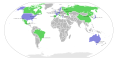
Winter Olympics
-
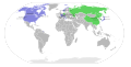
 Summer Olympics (The file that the latter is based on)
 -
 Winter Olympics


- Article(s)
- Winter Olympics
- Request
- Can you please make the black dots in the correct position in the Winter Olympics file (the latter one)? Thanks -- SpinnerLaserz (talk) 22:58, 4 December 2019 (UTC)
- Discussion
- Ok! Time to get to work! CreatingCatt@lk 17:16, 12 December 2019 (UTC)
![]() Done I finished this! CreatingCatt@lk 23:44, 12 December 2019 (UTC)
Done I finished this! CreatingCatt@lk 23:44, 12 December 2019 (UTC)
Severn-Trent flyway
-
 This could be a suitable base map, if cropped

- Article(s)
- Severn-Trent flyway
- Request
- Please could we have a map of England, from the Humber estuary to the Severn estuary only, with the Humber, Trent, Tame and Severn marked and labelled? Andy Mabbett (Pigsonthewing); Talk to Andy; Andy's edits 15:02, 16 November 2019 (UTC)
- Discussion
![]() Request taken by — Sarge (talk) 13:20, 17 December 2019 (UTC).
Request taken by — Sarge (talk) 13:20, 17 December 2019 (UTC).