Wikipedia:Graphics Lab/Map workshop/Archive/Dec 2010
Stale
editBritish local authority changes
edit
Applies to all subpages of List of civil parishes in England (47 counties) and to List of communities in Wales (8 preserved counties). Also applies to the articles on those counties, and on Northern Ireland and the Scottish local authorities. The six metropolitan counties in England already have maps showing the former local authorities and the two-tier structure created in 1974 (examples shown below).
There is some discussion at User talk:Lozleader/Archive 2#How are these? and User talk:Lozleader/Archive 2#County Borough of Leeds which may help to provide sources. I realise this is likely to be a massive project, and is not likely to be achieved in a short timescale.
-
 Tyne and Wear
 -
 Greater Manchester
 -
 West Midlands
 -
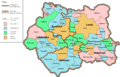 West Yorkshire
 -
 South Yorkshire
 -
 Merseyside

.png)


Article(s): Maps are required for Avon; Bedfordshire; Berkshire; Borders; Buckinghamshire; Cambridgeshire; Central; Cheshire; Cleveland; Clwyd; Cornwall; Cumbria; Derbyshire; Devon; Dorset; Dumfries and Galloway; Durham; Dyfed; East Sussex; Essex; Fife; Gloucestershire; Grampian; Greater London; Gwent; Gwynedd; Hampshire; Hereford and Worcester; Hertfordshire; Highland; Humberside; Isle of Wight; Kent; Lancashire; Leicestershire; Lincolnshire; Lothian; Mid Glamorgan; Norfolk; North Yorkshire; Northamptonshire; Northern Ireland; Northumberland; Nottinghamshire; Orkney; Oxfordshire; Powys; Shetland; Shropshire; Somerset; South Glamorgan; Staffordshire; Strathclyde; Suffolk; Surrey; Tayside; Warwickshire; West Glamorgan; West Sussex; Western Isles; and Wiltshire.
Maps of the subsequently revised counties would also be useful: Aberdeen; Aberdeenshire; Angus; Bedfordshire; Berkshire; Blaenau Gwent; Bridgend; Bristol; Caerphilly; Cardiff; Carmarthenshire; Ceredigion; Cheshire; Clackmannanshire; Conwy; Denbighshire; Dundee; Durham; East Ayrshire; East Lothian; East Renfrewshire; East Riding of Yorkshire; Edinburgh; Falkirk; Flintshire; Glasgow; Gloucestershire; Gwynedd; Herefordshire; Inverclyde; Isle of Anglesey; Kent; Leicestershire; Lincolnshire; Merthyr Tydfil; Midlothian; Monmouthshire; Moray; Neath Port Talbot; Newport; North Ayrshire; North Lanarkshire; North Yorkshire; Pembrokeshire; Perth and Kinross; Powys; Renfrewshire; Rhondda Cynon Taf; Rutland; Scottish Borders; Shropshire; Somerset; South Ayrshire; South Lanarkshire; Stirling; Swansea; Torfaen; Vale of Glamorgan; West Lothian; Worcestershire; and Wrexham (some of these are very small differences).
Request: Create according to the provided sources... Skinsmoke (talk) 09:54, 6 October 2010 (UTC)
- You might want to ask User:Nilfanion, who is using OS OpenData to generate a large number of maps relating to Great Britain administrative boundaries. In particular, see commons:User:Nilfanion/Maps. (Also discussed at Wikipedia talk:UK Wikipedians' notice board#Locator maps from OS opendata and Template talk:Infobox UK place#New maps.) I don't know whether Nilfanion is already involved with Wikipedia:Graphic Lab, so apologies if this confuses established the established wikigraphist procedure! — Richardguk (talk) 00:41, 7 October 2010 (UTC)
- Thanks for that. I've asked him to have a look at this page and see if he is able to help. Skinsmoke (talk) 07:26, 7 October 2010 (UTC)
- Unfortunately, I can't really do a great deal to help here, as OpenData info only contains current boundaries. In some (many?), but not all, cases the old boundaries can be constructed from the modern boundaries (I have data for districts, constituencies, parishes, electoral divisions and wards). For example, the Cornish districts abolished in 2009 could be extracted from the parish data, but the ~1970 boundary of Chester-le-Street Rural district is "lost". I also don't have access to the information needed to draw the boundaries. Therefore, all I can really do to help is upload the blank modern maps to enable others to build on them.
- One comment I would have, is how do you want to address changes in the county boundaries. For example, Werrington, Cornwall was in Devon until 1974 (I think), should it be shown on the maps for both counties?--Nilfanion (talk) 08:06, 7 October 2010 (UTC)
- I'd keep it on the new district/county. After all, none of the parishes/urban districts/boroughs were in the metropolitan counties prior to 1974; Cumbria was similarly constructed at that time, and the Oxfordshire/Berkshire boundary changed substantially; the Welsh authorities were all "new"; Suffolk and Lincolnshire were merged from their component parts, etc.— Preceding unsigned comment added by Skinsmoke (talk • contribs) 16:55, 7 October 2010.
- Thanks for that. I've asked him to have a look at this page and see if he is able to help. Skinsmoke (talk) 07:26, 7 October 2010 (UTC)
- Actually I think the request is too limiting compared to what should be done. The area boundaries are constantly evolving (eg these amendments in 1990). Whilst a full sequence, with all the minor tweaks isn't important there are several stages which would benefit from illustrating. The most obvious nationally are 1889 and 1974, but on a more localised basis more maps would be good: For example, 2009 before the recent large unitary councils, 1965 before Greater London was created - in the case of London I'd say 1965 is more significant than 1974. Given that all of these would be of significant value it would be worth enumerating more clearly what it is you want - just taking one snapshot comparing the pre-1974 situation to today seems inadequate.--Nilfanion (talk) 21:41, 7 October 2010 (UTC)
- Sorry, I'd taken it as read that 1965 was the key date for Greater London (and 1976, I think, for Scotland). 1889 is a key date because of the creation of modern counties and county boroughs, but 1894 is probably more significant as that was the date that urban districts and rural districts were created from the former urban sanitary districts and rural sanitary districts. We already have maps that illustrate the 1974–2009 districts compared to the super-unitaries, so that isn't really as urgent, though ultimately something with the same style throughout would be good. There were other key dates (1968 saw the creation of the large county boroughs in West Midlands, along with Torbay and Teeside for example, and I think that was also the year of wholesale change in Shropshire, where large rural districts were created. There were substantial changes also in the 1930s, when many smaller rural districts and urban districts vanished as a result of county reviews. However, don't you think we should learn to walk before we try to run? We already have a start made on the 1974 changes, and it would be useful to have those extended to cover the whole country (with the proviso that we are talking about the equivalent dates for Scotland, Wales, Northern Ireland and Greater London) before we launch onto another major project. Skinsmoke (talk) 23:52, 12 October 2010 (UTC)
- Yeah - that's clearer on the important dates. That said, in a sense the stumbling block here is the data not quantity. One option would be to utilise the old maps available at http://visionofbritain.org.uk . This map of Lancs is PD so could be uploaded, and it should be "simple" to trace to boundaries and convert to a simple png like the existing maps.--Nilfanion (talk) 09:24, 13 October 2010 (UTC)
- Sorry, I'd taken it as read that 1965 was the key date for Greater London (and 1976, I think, for Scotland). 1889 is a key date because of the creation of modern counties and county boroughs, but 1894 is probably more significant as that was the date that urban districts and rural districts were created from the former urban sanitary districts and rural sanitary districts. We already have maps that illustrate the 1974–2009 districts compared to the super-unitaries, so that isn't really as urgent, though ultimately something with the same style throughout would be good. There were other key dates (1968 saw the creation of the large county boroughs in West Midlands, along with Torbay and Teeside for example, and I think that was also the year of wholesale change in Shropshire, where large rural districts were created. There were substantial changes also in the 1930s, when many smaller rural districts and urban districts vanished as a result of county reviews. However, don't you think we should learn to walk before we try to run? We already have a start made on the 1974 changes, and it would be useful to have those extended to cover the whole country (with the proviso that we are talking about the equivalent dates for Scotland, Wales, Northern Ireland and Greater London) before we launch onto another major project. Skinsmoke (talk) 23:52, 12 October 2010 (UTC)
Graphist opinion(s):
Omsk oblast vector map
edit-
 Omsk oblast map
 -
 positioned here

.svg)
Article(s): Omsk, Omsk Oblast, various others
Request: Can someone make an svg version of the Omsk oblast map? FYI, the following references include water bodies, unlike the wiki-uploaded map: [1] [2] Thanks! Sibiryak (talk) 22:31, 30 September 2010 (UTC)
Graphist opinion(s):
![]() Done
Black and white, like the sample image, but with blue (cyan) hydrography per the links? Any other features wanted? Odysseus1479 (talk) 02:38, 4 October 2010 (UTC)
Done
Black and white, like the sample image, but with blue (cyan) hydrography per the links? Any other features wanted? Odysseus1479 (talk) 02:38, 4 October 2010 (UTC)
- Thank you very much! It'd be great to have the standard color scheme, like the one of Tyumen [[3]] (btw, Tyumen's E part includes hydrography of NW part of Omsk, if that helps). And would it be possible to make the map "more horizontal" by including the data of adjacent regions to the left ([[4]]) and to the right ([[5]],[[6]]), so that the map is not so tall when scaled to standard horizontal size by Russian city infobox? Sibiryak (talk) 02:09, 5 October 2010 (UTC)
- A vectorized version of the original, including lakes and the streams that were named on the map images you linked above, is at File:Omsk Oblast notext.svg. Please note that there is much less detail in this image than in the ‘neighbouring’ SVGs, especially the oblast and district borders. I suspect those maps were created from GIS data—or perhaps traced from large-scale originals.
- Regarding your request for a “landscape” or wide-aspect version, I’ll give you two options:
- with the smaller rivers removed; or
- with a similar amount of hydrographic detail, for which I would need more source images, similar in scale to the JPEGs linked above (or larger).
- I don’t think I can just extend the background & oblast borders of the existing map: a few rivers, notably the Om, would end abruptly, and elsewhere it would be implied that no similar-sized rivers exist. Odysseus1479 (talk) 01:58, 13 October 2010 (UTC)
- Beautifully done! Thank you, Odysseus1479!
- I've replaced Omsk-Oblast.png with your svg file in template [[7]], so now Omsk shows your map, yet the template itself doesn't... I must be doing something incorrectly...
- As for the landscape version, perhaps it would indeed be easiest to have one with smaller rivers removed? Thanks a bunch! —Preceding unsigned comment added by Sibiryak (talk • contribs) 01:15, 14 October 2010 (UTC)
- Sorry, I don’t know anything about editing templates yet. Yes, it will be pretty easy to make a landscape version if I ‘prune’ the rivers. Odysseus1479 (talk) 02:46, 14 October 2010 (UTC)
- A landscape version is now at File:Omsk Oblast region notext.svg. Please let me know if the proportions aren’t right or if you see anything else wrong, with either graphic. Odysseus1479 (talk) 06:15, 14 October 2010 (UTC)
- Thank you! Btw, do you know what the new border coordinates are? The original longtitudes of vertical borders were 70.37E to 76.28E, so I can probably figure it out by scaling, but you might already know the values... This is needed to update the template. Everything looks great! —Preceding unsigned comment added by Sibiryak (talk • contribs) 01:08, 15 October 2010 (UTC)
- Not exactly, no: I was working entirely ‘visually’, orienting to the original images rather than an explicit lat/long grid. I don’t even know whether the meridians are parallel or not—which goes to show one of many advantages of a GIS-based map. But from a look at Google Earth I think that stating the range as 67°0' to 79°20' E (or 67°.0 – 79°.3) would be adequately precise. Odysseus1479 (talk) 01:36, 15 October 2010 (UTC)
- Thank you! Btw, do you know what the new border coordinates are? The original longtitudes of vertical borders were 70.37E to 76.28E, so I can probably figure it out by scaling, but you might already know the values... This is needed to update the template. Everything looks great! —Preceding unsigned comment added by Sibiryak (talk • contribs) 01:08, 15 October 2010 (UTC)
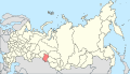
Yakutia vector map
edit-
 Yakutia map
 -
 Russia svg map


Article(s): location map for various places of Yakutia
Request: Can somebody make a svg version of Yakutia map like the Omsk oblast map (bellow) or various other Russian subdivisions? Hugo.arg (talk) 09:32, 20 September 2010 (UTC)
Graphist opinion(s):
![]() Done
Done
- A redrawn version is at File:Yakutia notext.svg. The district boundaries are somewhat crude, as they were just traced from the rather rough original image, but the other elements were adapted from the large vector map. Odysseus1479 (talk) 09:15, 16 October 2010 (UTC)
- Great work, thank you! Hugo.arg (talk) 08:18, 17 October 2010 (UTC)
- Regarding the coördinates, I don’t know enough about how the location-finding templates deal with non-rectilinear projections of large areas to say how the limits should be specified. (See my posting re Omsk Oblast on this page.) From the position of the midpoint of each edge, however, I estimate that the map extends from 55°.1 to 76°.8 N, and from 104°.5 to 160°.5 E. The ratio between east-west scales at the top and bottom is about 2.3 : 1. Odysseus1479 (talk) 01:45, 20 October 2010 (UTC)
- Correction: I meant to say that the size of a degree of longitude differs by 2.3 : 1. Dividing by the true ratio, cos(55)/cos(77) ~= 2.5, shows that the actual scale variation is only on the order of 10%. Odysseus1479 (talk) 18:47, 20 October 2010 (UTC)
- If you're modifying either latitude or longitude by a constant factor, I think it still counts as an equirectangular projection, it just has a different standard parallel (see here). Such transformations shouldn't be a problem with the location templates on wikipedia. It's fairly common for maps to have the scale in one direction changed so that shapes match what it actually looks like at some point within the map (e.g. the centre). gringer (talk) 07:59, 21 October 2010 (UTC)
- It’s definitely not equirectangular: the meridians converge and the parallels are curved. I think it’s most likely a conic of some kind. Odysseus1479 (talk) 01:55, 22 October 2010 (UTC)
Paralympic nations
edit-
 Description of image

Article(s): National Paralympic Committee
Request: This is a map of the Olympic nations. Could someone make a similar map, only with the Paralympic nations instead? Which nations to include, can be found in the National Paralympic Committee article. Bib (talk) 23:42, 9 October 2010 (UTC)
Graphist opinion(s):
- You could do some preliminary work by indicating which nations not to include. Wereldburger758 (talk) 12:23, 21 October 2010 (UTC)
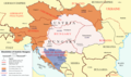
Military of Serbian Krajina
edit-
 Territorial divisions of the Military of Serbian Krajina

Article(s): Military of Serbian Krajina, United Nations Security Council Resolution 947, Operation Flash, Operation Storm
Request: I noticed this map just now, and it's a pretty useful historical illustration, but it's a coarse JPEG rather than a simple PNG. It also has a lot of Croatian labels, though barely readable, implying a possible copyright problem (the uploader's talk page looks fishy on first sight). Yet, these things aren't actually necessary at all, it should be possible to easily replace it with an OpenStreetMap PNG or an SVG map of Croatia, with the six colored areas analogously highlighted.
Also there's a slight factual error on the existing map - there's an unexplained lack of contact between the rose-colored 39th Corps area and the green-colored 18th Corps areas - that is the location of Hrvatska Dubica which was indeed under the control of the RSK army between 1991 and 1995 so it should be marked on the map.
I hope it's not too much to ask :) --Joy [shallot] (talk) 14:17, 22 October 2010 (UTC)
Graphist opinion(s):
Resolved
editAnschluss
edit-
 German
 -
 English


Article(s): Anschluss
Request: English version please... Kintetsubuffalo (talk) 18:12, 18 November 2010 (UTC)
- Have you tried contacting the original uploader, it might be easier for him to do a translation. P. S. Burton (talk) 10:49, 19 November 2010 (UTC)
- His userpage clearly states "en:2-This user is able to contribute with an intermediate level of English." This is the appropriate place to bring it.--Kintetsubuffalo (talk) 23:12, 20 November 2010 (UTC)
- What I meant is that he probably still has the original svg or psd file on his harddrive. Working with that file would be easier, because that would mean that the map won't have to be redrawn from scratch just to change the labels. P. S. Burton (talk) 16:39, 21 November 2010 (UTC)
- His userpage clearly states "en:2-This user is able to contribute with an intermediate level of English." This is the appropriate place to bring it.--Kintetsubuffalo (talk) 23:12, 20 November 2010 (UTC)
Graphist opinion(s):
![]() Request taken by P. S. Burton.: I will give it a try. P. S. Burton (talk) 18:47, 23 November 2010 (UTC)
Request taken by P. S. Burton.: I will give it a try. P. S. Burton (talk) 18:47, 23 November 2010 (UTC)
 Done Can you please check if I forgot something, or mistranslated something, before I add it to the article. P. S. Burton (talk) 21:43, 23 November 2010 (UTC)
- That is a huge amount of work on your part, thank you! Two quickies:
- It literally says "Russian Soviet", but in English it becomes "Russian Soviet Federative Socialist Republic" or "Russian SFSR", whichever you have space for. :)
- Ungarn in the infobox=Hungary
- Thank you again!--Kintetsubuffalo (talk) 14:18, 24 November 2010 (UTC)
- I found one mistake, but maybe it's deliberate: Fiume (Rijeka) should stay like that, as it was only transferred to Yugoslavia and renamed Rijeka until after WWII. Richardprins (talk) 20:51, 24 November 2010 (UTC)
Italy
edit
Article(s): Italy
Request: lettering is beautiful but unencyclopedic. can we wikify it? Kintetsubuffalo (talk) 04:28, 8 November 2010 (UTC)
Graphist opinion(s): Have you tried contacting the original author? Also note that this map is part of a series (highly laudable, IMHO), all of which feature distinctive fonts. Classical geographer (talk) 09:39, 8 November 2010 (UTC)
- I also think this one is fine as is. Kmusser (talk) 16:41, 8 November 2010 (UTC)
- I agree that this map should not be changed. P. S. Burton (talk) 03:27, 19 November 2010 (UTC)
Antarctica
edit
Article(s): Antarctica
Request: remove border and top caption per WPMOS... Chris (クリス • フィッチ) (talk) 10:36, 25 October 2010 (UTC)
Graphist opinion(s):
Belgium-Congo relations
edit-
 Purposed image

Article(s): Belgium-Congo relations
Request: Need an introductory map for this as per other such relations pages. Thanks. Lihaas (talk) 14:33, 30 November 2010 (UTC)
Graphist opinion(s): Make a choiche between the model shown in Belgium-Canada relations (without circles), and the one shown in Belgium-Mexico relations (with circle around the more little country). Normally, the country shown in green is the first by two in alphabetical order, so in this case Belgium will be green.Ciaurlec (talk) 16:37, 2 December 2010 (UTC)
Indonesia-Netherlands relations
edit-
 Purposed image

Article(s): Indonesia-Netherlands relations
Request: Per above, also need an introductory map for this. Thanks again. Lihaas (talk) 16:42, 30 November 2010 (UTC)
Graphist opinion(s):As for the previous request make a choiche between the model shown in Canada–Netherlands relations (without circles), and the one shown in Japan–Netherlands relations (with circle around the more little country). here you have to specify if netherlands Antilles have to be coloured or not. PS. I'm a beginner, please be patient ;-) Ciaurlec (talk) 16:42, 2 December 2010 (UTC)
- not my request; but I do have an opinion: I could hardly see NL in the Canada-NL variant, so prefer the circles. And relationships are always of teh kingdom of the Netherlands, so should inculde also the Caribbean part of the Kingdom. But Lihaas has the last word on this... L.tak (talk) 16:46, 2 December 2010 (UTC)
- I personally think its silly to include that, we dont have Diego Garcia and the Falklands for the UK or the Carib./Pacific French territories. (think it should go from that page too). But it doesnt really bother me either way.Lihaas (talk) 16:42, 30 November 2010 (UTC)
2018 FIFA World Cup
editArticle(s): 2018 FIFA World Cup
Request: We need a map of the location cities of the stadia in Russia akin to 2022 FIFA World Cup#VenuesLihaas (talk) 18:09, 2 December 2010 (UTC)
Graphist opinion(s): Article(s): 2018 FIFA World Cup
Request: Since the FIFA World Cup hosts were announced yesterday, I took a look at the 2018 FIFA World Cup page, and was not very happy with the map, which had been done on the basis of your “Location map+ |Russia”. The reason for this is that all of the proposed host cities are in European Russia, and the in present map the locations are rather crowded, and one does not get a good idea of where the host cities are located.
I thought that if there was a map showing European Russia, things would be much more clear and the map would be more informative.
Could someone do a “Location map+ | European Russia”, which could be used for the 2018 FIFA World Cup page?
I did send a note to I did send a note to Амба about this, since he/she is the author of the above mentioned map of Russia. about this, since he/she is the author of the above mentioned map of Russia.
Below is the current map in the article 2018 FIFA World Cup.

Apanuggpak (talk) 18:39, 3 December 2010 (UTC)
Graphist opinion: Амба made the template, but not the map, that was me,me,me. ;-) I made a new map and a new template:
.svg)
greetings, Uwe Dedering (talk) 22:31, 5 December 2010 (UTC)
![]() Done
Done
Awesome, you're the man. I'm so gonna use this (in the Spanish Wikipedia, which it's where I come from) Dove (talk) 17:06, 6 December 2010 (UTC)
Colour not up to date
edit-
![Vector derivative of [:File:Gini Coefficient World CIA Report 2009.svg] Based on https://www.cia.gov/library/publications/the-world-factbook/fields/2172.html](//upload.wikimedia.org/wikipedia/commons/thumb/3/32/Gini_Coefficient_World_CIA_Report_2009.svg/120px-Gini_Coefficient_World_CIA_Report_2009.svg.png) Vector derivative of [:File:Gini Coefficient World CIA Report 2009.svg] Based on https://www.cia.gov/library/publications/the-world-factbook/fields/2172.html
Vector derivative of [:File:Gini Coefficient World CIA Report 2009.svg] Based on https://www.cia.gov/library/publications/the-world-factbook/fields/2172.html
![Vector derivative of [:File:Gini Coefficient World CIA Report 2009.svg] Based on https://www.cia.gov/library/publications/the-world-factbook/fields/2172.html](/wiki/File:Gini_Coefficient_World_CIA_Report_2009.svg)
Article(s): Gini coefficient
Request: On this map a wrong colour is used for Belarus and Croatia; according to the table below the map, it should be light blue for Belarus and light orange for Croatia. 94.253.155.30 (talk) 23:53, 6 November 2010 (UTC)
Graphist opinion(s): ![]() Done I updated Belarus, Croatia appeared to be correct. Kmusser (talk) 20:37, 8 November 2010 (UTC)
Done I updated Belarus, Croatia appeared to be correct. Kmusser (talk) 20:37, 8 November 2010 (UTC)
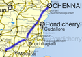
Request for Map - State Highway SH-134
edit
Article(s): State Highway 134 (Tamil Nadu),Marakkanam, Tindivanam, Brahmadesam
Request: Hi Wikipedians, I'm trying to create a complete database for State Highways of Tamilnadu (India) for which i require Good map to indicate in the Info Section. Following is the route for which map has to be created.
Starting Point Tindivanam - - -(12°13′00″N 79°39′36″E / 12.216626°N 79.659934°E)
Endiyur- - - - -(12°12′33″N 79°41′40″E / 12.209076°N 79.69458°E)
Guruvamampettai-(12°12′44″N 79°42′25″E / 12.212159°N 79.707053°E)
Kattalai - - - -(12°12′41″N 79°43′05″E / 12.211465°N 79.718116°E)
Ravanapuram - - (12°12′40″N 79°43′36″E / 12.211061°N 79.726758°E)
Perumukkal - - -(12°12′25″N 79°44′27″E / 12.206968°N 79.740849°E)
Nallalam - - - -(12°12′19″N 79°44′34″E / 12.205395°N 79.742716°E)
Sotkanthangal - (12°12′10″N 79°45′24″E / 12.202857°N 79.756545°E)
Velakulam - - - (12°12′08″N 79°45′46″E / 12.20226°N 79.762886°E)
Brahmadesam-(12°11′59″N 79°47′12″E / 12.199858°N 79.786533°E)
Enthur - - - - -(12°12′03″N 79°46′42″E / 12.200708°N 79.778325°E)
Rajampalayam - -(12°11′58″N 79°47′27″E / 12.199523°N 79.790942°E)
Puthuppakam - - (12°11′58″N 79°47′48″E / 12.199376°N 79.796789°E)
Alankuppam - - -(12°12′01″N 79°48′33″E / 12.200204°N 79.809203°E)
Siruvadi - - - -(12°12′12″N 79°50′16″E / 12.203245°N 79.837666°E)
Murukkery - (12°12′13″N 79°50′22″E / 12.203654°N 79.839361°E)
Kandadu
Kurumbaram
Kesanampalayam
Marakkanam -(12°11′48″N 79°56′33″E / 12.196579°N 79.942584°E
If you are able to provide a map something like the below, i will be so grateful.
-
 National Highway(India)
 -
 National Highway(India
 -
 National Highway(India)
.png)
.png)
.png)
![[1]](http://www.univer.omsk.su/omsk/im/omskreg.JPG)
![[2]](http://www.omskcottage.ru/images/karta1.jpg)
![[3]](https://en.wikipedia.org/wiki/File:Outline_Map_of_Tyumen_Oblast.svg)
![[5]](https://en.wikipedia.org/wiki/File:Tomsk_region_blank.png)
![[6]](https://en.wikipedia.org/wiki/File:Outline_Map_of_Novosibirsk_Oblast.svg)
Raj 6644(தமிழன்) 12:54, 3 August 2010 (UTC)
Graphist opinion(s):
- Are you aware of OpenStreetMap? The data in Tamil Nadu is currently extremely patchy - only 14 of the state highways are labelled with a number, and some of those are broken up into small pieces. OSM could use interested contributors who know their way around the road network and are capable of the simple task of digitizing ways. Is there any reason you're asking for SH-134 in particular, or are you planning to try to do the entire state highway network? This sounds like a serious undertaking. Do you know of any good Tamil Nadu highway maps in existence that are online, whether freely licensed or not? Lesqual (talk) 18:59, 6 August 2010 (UTC)
- It would be quite the undertaking, I can give a couple of tips to anyone willing to take on the task. All existing Indian highway maps have been created by User:Abhijitsathe based on File:India roadway map.svg so I'd recommend following that style. I note that Raj has asked about this elsewhere as well and has at least one nibble on his talkpage already. This particular highway was too small for File:India roadway map.svg. There is more detailed GIS data for Indian roads freely available via Vector Map at http://gis-lab.info/qa/vmap0-eng.html that could be used to complete this request, I'm not sure how current that data is, but this highway does appear to be on it. That data does not have labels though, you might need to use Google Maps to figure out which highway is which. Kmusser (talk) 19:45, 6 August 2010 (UTC)
- Thank you Lesqual & Kmusser for stepping to help. I have already requested User:Abhijitsathe for the same subject. I guess he is on WikiBreak Now. User:Kmusser has given really very usefull information in technical front for creation of the map. But really i dont know anything about Graphic Design & Map Making. As i have mentioned in my previous post i'm trying to create Database for State highways in TN. If the Article for State Highway SH-134 materializes then i will go ahead with Creating the State Highways. To kick start any one please create a map with details given by User:Kmusser.
- Apart from the above Google map Map link, i have found the SH-134 on Openstreetmap at " State Highway SH-134 at Openstreetmap
- It would be quite the undertaking, I can give a couple of tips to anyone willing to take on the task. All existing Indian highway maps have been created by User:Abhijitsathe based on File:India roadway map.svg so I'd recommend following that style. I note that Raj has asked about this elsewhere as well and has at least one nibble on his talkpage already. This particular highway was too small for File:India roadway map.svg. There is more detailed GIS data for Indian roads freely available via Vector Map at http://gis-lab.info/qa/vmap0-eng.html that could be used to complete this request, I'm not sure how current that data is, but this highway does appear to be on it. That data does not have labels though, you might need to use Google Maps to figure out which highway is which. Kmusser (talk) 19:45, 6 August 2010 (UTC)
- Also i like to confirm to Lesqual & every1, i have very good idea about the State Highway SH-134 as i was born & brought up in that locality. i have good knowledge about SH-134, SH-05,SH-49,NH-45, NH-66 of Tamilnadu in which have traveled numerous times. I can assit the map maker with perfect geographical points.
---Raj 6644(தமிழன்) 10:33, 7 August 2010 (UTC)
Indian Highways Wikiproject
editSo... I have collected the following from public domain sources
- 1:1M Vmap0 road data for India, in individual road segments, with minimal & out of date hierarchical categorization but good detail
- 1:10M CDC Epi-Info first-level administrative boundaries
I've also found a similar request for the state of Kerala in the archives. A highway atlas of Tamil Nadu is a serious undertaking, a highway atlas of all India much more so. As I've noted, GIS tasks are commonly easy to pipeline and hard to start. To create a good map of one highway I have to get linework on the several dozen other highways nearby, while shifting the focus to cover those highways instead is trivial, so why not just make a whole state or country at once?
Here's one map on the old National Highways from the Indian Embassy in Peru. I'll supplement that with the written announcement on the new NH numbering system and mark the segments in the Vmap0 data, and eventually I'll have a basemap for the NH system (which is a necessary feature in any state highway map).
What I need now are official sources on the Tamil Nadu (and Kerala, and everywhere else, for that matter) state highway system. I'd prefer geospatial data, but I can adapt the segments I have if necessary. A non-free licensed map would be fine, as long as it's a reliable/official source.
Would it be okay if I supplied you with an interim product (Agile methods ahoy!) that just has the state of Tamil Nadu and this particular highway, with nothing else marked? Lesqual (talk) 16:59, 9 August 2010 (UTC)
- Something like this for Tamil Nadu would be useful even if it isn't a map. Meanwhile this shows me what National Highways I need to have for Tamil Nadu. Lesqual (talk) 17:15, 9 August 2010 (UTC)
- Come to think of it, there's actually a verbal map listing on the WP page (which I guess is where you're getting your SH numbers for the template), but I can't find a citation that matches. Where did this big table come from? Who asserts that there are ~188 state highways in Tamil Nadu, and they follow these courses? Lesqual (talk) 17:38, 9 August 2010 (UTC)
- Lesqual, I can understand the requirement for making the State Highway Road Network map. Also i like to appreciate your effort to deliver a quality map.As i'm from Tamilnadu i can verify & tell the reliability of the List for State Highways in Tamilnadu. The list given is correct, but the source for the information is not clear even from the references cited in the page. Highways Department, TN is the responsible authority for development of State Highways & Major District Roads.but in their website i'm not able to find proper information. But i'm able to find a strong reference / information for [8] roads in Tamilnadu] from NATIONAL RURAL ROADS DEVELOPMENT AGENCY (NRRDA), Govt of India's website. Please give me some time, i'm confident that i can come back in 1 or 2 days with still more sources. ----Raj 6644(தமிழன்) 05:39, 12 August 2010 (UTC)
 Unresolved
 No action. I request any1 to take action on the above request. ---Raj 6644(தமிழன்) 12:45, 17 August 2010 (UTC)
- I think Lesqual is working on it, I wouldn't expect results quickly though - it's a big project, I know it would take me a couple of months if I were doing it. Kmusser (talk) 13:30, 17 August 2010 (UTC)
- Fine Kmusser!. If any1 is working then i'll be very happy. As no1 has replied for longtime, I thought the requested was dropped. ---Raj 6644(தமிழன்) 04:20, 18 August 2010 (UTC)
- No progress on this request for the past 20days. Is this request dropped. Kmusser & Lesqual Would you pls take-up this.Your support is required to make it. ----Raj 6644(தமிழன்) 08:07, 9 September 2010 (UTC)
- Lesqual, let me know if you're not planning on doing this one - and I'll take it on, if I'm doing it though don't expect results before early 2011. Kmusser (talk) 10:41, 9 September 2010 (UTC)
- I'm still interested, though I don't want to use this sketchy list without knowing where it came from, and I'm just beginning to set up an environment where I can work on the SH's (95% done the NH's) and digitize. In the interest of educating us on map-making, do you think you could explain how you'd tackle this project? Lesqual (talk) 19:29, 10 September 2010 (UTC)
- 2011!! Is this that much big project. I'm not aware of the volume of this project. I'm not taking, because i don't know anything about map creation. —Preceding unsigned comment added by Raj6644 (talk • contribs) 11:54, 9 September 2010 (UTC)
- Wikipedia's competing interests clash a bit with maps. There is legal ambiguity around the idea of map copyright which makes it difficult to include most geographic data directly - but editors do need a reference other than their own personal experience or secondhand experience. We much prefer to infer facts based on multiple references, because the errors (or even copyright easter eggs) do pile up. If you want to contribute your personal knowledge of the area, the best path would probably be to become an active OpenStreetMap Editor. They digitize Yahoo aerial photography & sometimes their own GPS traces, and most contributions are based in part on personal knowledge. As an encyclopedia, references to reliable sources are desired here, and to be honest almost all of the Tamil Nadu highway articles lack cited reliable sources, other than the NH text-route list. If you could get more data out of Survey of India or the Tamil Nadu Highways Department that would make things a lot easier. At the moment, my compromise is using OSM lines in Arcmap and marking them up with information from the official highway department map (which only labels national highways) Even here, there are conflicts. I'm not sure where to begin marking the state highways absent a citation for that list, but even with one I highly doubt more than a handful are completely marked on the OSM dataset. For those that aren't marked or are incomplete, adding just one involves a lot of digitizing from aerial photography & research. This stuff is better done by locals on the official OSM page. It can be corrected, work can be spread out over more people, local knowledge is infinitely better and easier than internet research, and most importantly the knowledge won't die when this map is finished. I'm certainly willing, and I can try marking the state highways that are present in my data, but I think given your interests you're a great fit for an OSM contributor, and if you built your highway database on that I could reduce my role to cartography & SVG work. If not, understand that it's a very long-term project. Lesqual (talk) 19:29, 10 September 2010 (UTC)
- Lesqual, let me know if you're not planning on doing this one - and I'll take it on, if I'm doing it though don't expect results before early 2011. Kmusser (talk) 10:41, 9 September 2010 (UTC)
- No progress on this request for the past 20days. Is this request dropped. Kmusser & Lesqual Would you pls take-up this.Your support is required to make it. ----Raj 6644(தமிழன்) 08:07, 9 September 2010 (UTC)
- Fine Kmusser!. If any1 is working then i'll be very happy. As no1 has replied for longtime, I thought the requested was dropped. ---Raj 6644(தமிழன்) 04:20, 18 August 2010 (UTC)
- I think Lesqual is working on it, I wouldn't expect results quickly though - it's a big project, I know it would take me a couple of months if I were doing it. Kmusser (talk) 13:30, 17 August 2010 (UTC)
- Lesqual, I can understand the requirement for making the State Highway Road Network map. Also i like to appreciate your effort to deliver a quality map.As i'm from Tamilnadu i can verify & tell the reliability of the List for State Highways in Tamilnadu. The list given is correct, but the source for the information is not clear even from the references cited in the page. Highways Department, TN is the responsible authority for development of State Highways & Major District Roads.but in their website i'm not able to find proper information. But i'm able to find a strong reference / information for [8] roads in Tamilnadu] from NATIONAL RURAL ROADS DEVELOPMENT AGENCY (NRRDA), Govt of India's website. Please give me some time, i'm confident that i can come back in 1 or 2 days with still more sources. ----Raj 6644(தமிழன்) 05:39, 12 August 2010 (UTC)
- Come to think of it, there's actually a verbal map listing on the WP page (which I guess is where you're getting your SH numbers for the template), but I can't find a citation that matches. Where did this big table come from? Who asserts that there are ~188 state highways in Tamil Nadu, and they follow these courses? Lesqual (talk) 17:38, 9 August 2010 (UTC)
- I think my approach would be very similar to what you're already talking about. I'd probably start with vmap0 instead of OSM because it tends to be more complete, although it might also be more out of date. I wouldn't have any problem with using the wiki list as a starting point for what to include. For each highway you'd still need to confirm a start and end point from another source, which might require digitizing corrections regardless of what basemap you use. I'd actually use Google Maps as a backup to official maps to determine the route, start, and end points. As long as you're not using their linework shouldn't run afoul of copyrights. Kmusser (talk) 15:30, 11 September 2010 (UTC)
- For a complete different approach that wouldn't make nice individual maps for each highway, but would be much faster, we could try and turn the map the Raj already uploaded into a location template and just use pushpins to show the route. Kmusser (talk) 15:30, 11 September 2010 (UTC)
- Lesqual & Kmusser. I have checked out Open Street Map. I have checked out initially for SH-134. already the route is available, i have just verified & tagged it as SH-134. similarly i'll do for other SH's to the possbile extend. but before that i need to practice the OSM because this is the first time i'm using OSM. As Kmusser said google map already has good info which will be usefull in getting idea about Coordinates for the route. Thank you ----Raj 6644(தமிழன்) 04:44, 15 September 2010 (UTC)
- I have created two maps from open street map ; can we try more maps from osm ?please check State Highway 22 (Kerala) and State Highway 61 (Kerala) --naveenpf (talk) 16:42, 10 November 2010 (UTC)