Wikipedia:Graphics Lab/Map workshop/Archive/Aug 2011
Stale edit
Simple rectanglular and circular overlay on map of Eppawala, Sri Lanka edit
Article(s): Eppawala
Request: Is it possible to create a simple map based on this image: http://people.whitman.edu/~walterjs/eppawalamap.html. Only the geological features, the overlays, and the locations of Eppawala and Anuradhapura are important. Many thanks. Iae (talk) 14:24, 1 June 2011 (UTC)
Graphist opinion(s):
Crop top part of map edit
Article(s): Template:Seventh-day Adventist Colleges and Universities in North America map
Request: The above map template is in use on Template:Seventh-day Adventist Colleges and Universities in North America. What I would like to have done is to crop the top part of the map out so it does not unnecessarily expand the template. bW 21:24, 28 May 2011 (UTC)
Graphist opinion(s):
I believe that because it is a template the request is impossible. - Presidentman (talk · contribs) (Talkback) Random Picture of the Day 21:56, 4 June 2011 (UTC)
- It could be done, one would just need to edit the template to reposition the horizontal alignment of all the locations to match the new map. Monty845 04:22, 5 June 2011 (UTC)
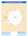
A better Orthographic Projection of Pakistan to avoid confusion of dispute places with India edit
-
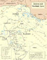 Map of disputed place by UN
 -
 Map of Pakistan currently using in wiki
 -
 Unfinishished Map requested (?)

.svg)
_wd.svg)
Article(s): Pakistan
Request: Please make a better image shows the locations of Pakistan to avoid confusion of places of Pakistan and India, exactly an orthographic projection
It should differentiate the following areas of Pakistan
1. Undisputed (without Northern Areas and parts of Azad Kashmir in dispute Kashmir territory)
2. Area controlled by Pakistan i.e. Occupied Kashmir/ Pakistan Administrated Kashmir (Dispute place between Pakistan and India)
3. And if necessary, Territories claimed by Pakistan (excluding Pakistan Administrated Kashmir)i.e. Kashmir
In different colors, preferably (as i believe :) ) dark green, medium green, and light green.
... Boshi33 (talk) 08:47, 30 May 2011 (UTC)
Graphist opinion(s):
Isn't this a bit overkill for an orthographic projection? It is my understanding that these sorts of maps are used in their articles merely to give the reader a general idea of where on the globe a particular country/area is located; I don't think this sort of level of detail is appropriate for that purpose. In addition, there's a perfectly good map later in the article (File:PAK_AU_T1.svg) which clearly delineates all the various degrees of disputed territories in the region. The current orthographic projection strikes a balance in showing where in the world land under the jurisdiction of Pakistan is located (dark green), while acknowledging the disputed territories (light green). -MissMJ (talk) 04:55, 5 June 2011 (UTC)
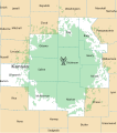
Mazatecan languages map edit
-
 Similar to this

Article(s): Mazatecan languages
Request: I need a map showing the Northern area of the Mexican state of Oaxaca and a bit of the surrounding states of Puebla and Veracruz (Pretty much this area [1][2]), marking the towns in which Mazatec is spoken - the map would ideally include main roads and landscape features such as mountaints, lowlands and the large lake/reservoir where Mazatec is spoken on the island of Soyaltepec. The Towns that need to be marked are: Huautla de Jimenez, Jalapa de Díaz, San Juan Chiquihuitlán, San Bartolomé Ayautla, Eloxochitlán de Flores Magón, Santa María Chilchotla, San Pedro Ixcatlán, San Miguel Soyaltepec, Santa María Jacaltepec, San Jeronimo Tecoatl, Mazatlán Villa de Flores. A map similar to the one I would like is at Mixe people (File:Sierramixes.png). ·ʍaunus·snunɐw· 16:35, 6 June 2011 (UTC)
Graphist opinion(s):
Resolved edit
Revise graphic showing Dulles flight destinations (super-easy) edit
-
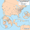 Illustration showing nonstop and direct flight destinations from Washington Dulles International AirportDescription of image

Article(s): Washington Dulles International Airport Oh, and these: Usage on de.wikipedia.org Flughafen Washington-Dulles-International Usage on es.wikipedia.org Aeropuerto Internacional Washington-Dulles Usage on zh.wikipedia.org 华盛顿杜勒斯国际机场
Request: Please change the dot for PEK (Beijing) to blue, as United now has a nonstop flight from Dulles. Thanks! A link to the graphic: http://en.wikipedia.org/wiki/File:Dullesairportmap4.png KBurchfiel (talk) 03:57, 6 July 2011 (UTC)
Graphist opinion(s):
Here it is. – ∃ Aditya 7 ¦ 04:46, 6 July 2011 (UTC)
South Sudan edit
Huge number of maps! With the independence of South Sudan, we need a lot of maps made and/or altered. World maps, African maps, Middle East maps, Arab League maps, maps for the new country itself, even maps of neighboring countries which may show borders (like Ethiopia and Chad).
Article(s): lots and many Request: A good source needs to be found for the official dividing line between Sudan and South Sudan (not to mention the Abyei Province issue). WikiProject South Sudan might be able to help. Good luck, all. Rmhermen (talk) 15:31, 9 July 2011 (UTC)
- Agree this is an issue of vital importance. Maps for Arab League, Arab world, Middle East, Greater Middle East, North Africa, East Africa, Africa, United Nations, Commonwealth of Nations, and every country or territory map that shows Sudan/South Sudan on the orthographic projection of the globe needs to be updated.
These articles' maps are all complete:
Delusion23 (talk) 09:57, 11 July 2011 (UTC)
Graphist opinion(s): Please see the talk page. -MissMJ (talk) 20:26, 12 July 2011 (UTC)
South Sudan political boundary updates edit
See: commons:Category:Maps_needing_South_Sudan_political_boundaries
Article(s): Many
Request: All these maps of Africa/the World need updating with the new South Sudan border with Sudan. The Africa-regions file needs South Sudan's colour changing to yellow as they are applying for membership of the East African Community and so will be considered part of East Africa not North. Thanks :) Delusion23 (talk) 10:01, 12 July 2011 (UTC)
Graphist opinion(s): Please see the talk page. -MissMJ (talk) 20:27, 12 July 2011 (UTC)
Midwestern USA, standalone edit
-
 Map of midwestern states
 -
 Map with text
 -
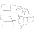 Map without text


Article(s): Midwestern United States
Request: Could this map be converted to SVG? Preferably, one with the overlaid text and one without would be awesome. Thanks! SchuminWeb (Talk) 19:55, 1 August 2011 (UTC)
Graphist opinion(s):
![]() DoneDerfel73 (talk) 11:49, 2 August 2011 (UTC)
DoneDerfel73 (talk) 11:49, 2 August 2011 (UTC)
- Awesome, thanks! SchuminWeb (Talk) 14:16, 2 August 2011 (UTC)
Derfel73 (talk) 12:12, 13 August 2011 (UTC)


I made some podunk pictures on paint that stink pretty bad. I did not even know about this, and I desire for some better maps to be made of this campaign, and it would be nice if you guys could make it. All the pictures are already cited, in addition to the fact that here is a picture of the campaign that I want a picture off. However, I want it divided up in several pictures like it is on the map in the article I made. Please let me know if this is possibleSteveMooreSmith3 (talk) 08:32, 15 July 2011 (UTC)
- It would be relatively easy to make some higher quality maps based on the existing uploads; are these accurate? Derfel73 (talk) 12:11, 15 July 2011 (UTC)
- Yes, could you also make one of the bottom map. Of the Cavalry chasing the infantry? The one thats more zoomed in? The maps are accurate. SteveMooreSmith3 (talk) 13:03, 16 July 2011 (UTC)
![]() Request taken by Derfel73.
Request taken by Derfel73.
- FYI, this is a good chance to update the maps to follow WikiProject Maps' conventions. -MissMJ (talk) 03:45, 17 July 2011 (UTC)

— Preceding unsigned comment added by Derfel73 (talk • contribs) 10:51, 17 July 2011 (UTC)
- OK, thatnks so much. SteveMooreSmith3 (talk) 14:34, 17 July 2011 (UTC)
- Will I be seeing the other ones anytime soon or should I expect to wait on those? There's no rush. And thanks so much for what you've already done. — Preceding unsigned comment added by SteveMooreSmith3 (talk • contribs) 14:35, 17 July 2011 (UTC)
- I'm working the other maps now; they should be all done in a few days. Could you clarify one or two things though:
- To what do the stripy yellow areas refer?
- And the green areas? (I did read the article in question, though if these questions were answered, I didn't spot the answers)
- Do the various black dots refer to villages (apart from those labelled otherwise, like "camp")?
- Derfel73 (talk) 16:11, 17 July 2011 (UTC)
- The green stuff is swamp. The Yellow stuff is desert. The black dots are camps and villages. Although just because they arent named doesn't mean they are camps. I believe all the camps are named
- I'm working the other maps now; they should be all done in a few days. Could you clarify one or two things though:
SteveMooreSmith3 (talk) 04:28, 18 July 2011 (UTC)
- are these maps anywhere close to being doneSteveMooreSmith3 (talk) 01:55, 21 July 2011 (UTC)
![]() Done Derfel73 (talk) 13:17, 21 July 2011 (UTC)
Done Derfel73 (talk) 13:17, 21 July 2011 (UTC)
World Association of Girl Guides and Girl Scouts edit
-

 Done
Done -

-
 Done
Done


.png)
 Not done copyrighted logo, cannot be changed
Article(s): World Association of Girl Guides and Girl Scouts
Request: update to include the borders of South Sudan, in orange... Kintetsubuffalo (talk) 13:09, 9 July 2011 (UTC)
Graphist opinion(s): People seem to have fixed images one and three, the second was added to the appropriate improvement category, and the fourth's license does not allow modifications. -MissMJ (talk) 07:47, 14 August 2011 (UTC)
Weather radio coverage maps edit
-
 WXM87
WXM87 -
 WXL71
WXL71 -
 KWN59
KWN59 -
 WXM87 vectorCoverageAlerting areas
 -
 WXL71 vectorCoverageAlerting areas
 -
 KWN59 vectorCoverageAlerting areas


Article(s): WXM87, WXL71, KWN59
Request: Please make the maps more Wikipedia friendly. More information about map style can be found at this similar request (and according to it, the pdf files linked as the source on the file information pages has vector data that can be used to make svg's). Thanks in advance, Ks0stm (T•C•G) 19:20, 14 August 2011 (UTC)
Graphist opinion(s):
![]() Request taken by Derfel73.. I have done the first file in the same manner as the previous graphic lab artist; if it would be more satisfactory to simply use the unedited vector file like the gif image, do say. A legend could be easily inserted in the thumbnail box containing the image or, if requested, could be added to the image itself. Derfel73 (talk) 20:56, 14 August 2011 (UTC)
Request taken by Derfel73.. I have done the first file in the same manner as the previous graphic lab artist; if it would be more satisfactory to simply use the unedited vector file like the gif image, do say. A legend could be easily inserted in the thumbnail box containing the image or, if requested, could be added to the image itself. Derfel73 (talk) 20:56, 14 August 2011 (UTC)
- I think that the style you've just done it in works the best, to be honest, both for consistency with the other ones and that it seems to look good. A legend would be much appreciated, and would probably be best worked via the thumbnail box so that it can be applied in multiple languages if necessary and for simplicity in applying it. Thanks for taking on this request. Ks0stm (T•C•G) 21:43, 14 August 2011 (UTC)
Highway map edit
-
 Map
Map
_map.svg)
Article(s): K-104 (Kansas highway)
Request: I've spent the last hour trying to follow WikiProject U.S. Roads' instructions to make a map for a highway article. Everything I make ends up looking terrible and very unlike existing highway maps. Please make one the same style as File:I-235 (KS) map.svg (including being county level with city limits...the only difference necessary is that the K-104 map should show state highways, as well) for K-104 (Kansas highway). Thanks in advance, Ks0stm (T•C•G) 06:06, 15 August 2011 (UTC)
_map.svg)
Graphist opinion(s):
![]() Request taken by Pi.1415926535. I should have it done for you within the hour. Pi.1415926535 (talk) 17:44, 20 August 2011 (UTC)
Request taken by Pi.1415926535. I should have it done for you within the hour. Pi.1415926535 (talk) 17:44, 20 August 2011 (UTC)
- Done I don't have town borders on here; it's not in a big city and it's so short that I'm not really sure having municipal borders is necessary, or even worth it. But it's your call; here's the best I can do. Pi.1415926535 (talk) 18:53, 20 August 2011 (UTC)
- While I'd still like a map the style I requested, this is an excellent map to have because it serves to zoom in and show the route in greater detail than a countywide map will do. It will work great in conjunction with a countywide map, which I think I will request from WP:USRD/MTF/R when the article passes its GAN it's currently up for. Awesome job and thanks.
Marking resolved.Actually, one more request...would it be possible for you to add a scale to it in miles & kilometers? Ks0stm (T•C•G) 19:09, 20 August 2011 (UTC)
- While I'd still like a map the style I requested, this is an excellent map to have because it serves to zoom in and show the route in greater detail than a countywide map will do. It will work great in conjunction with a countywide map, which I think I will request from WP:USRD/MTF/R when the article passes its GAN it's currently up for. Awesome job and thanks.