Wikipedia:Graphics Lab/Map workshop/Archive/Apr 2022
| This page is an archive. Do not edit the contents of this page. Please direct any additional comments to the current main page. |

Request rework of African conflicts map
-

-
 Finished map


- Article(s)
- Africa
- Request
- Hey, maybe somebody can create such map in png/svg? This poor jpeg is almost unreadable. -- Artem.G (talk) 10:38, 29 March 2022 (UTC)
- Discussion
![]() Request taken by M.Bitton (talk) 11:40, 29 March 2022 (UTC).
Request taken by M.Bitton (talk) 11:40, 29 March 2022 (UTC).
- Thanks, M.Bitton! The colours are not great here, but I'll leave it up to you, I have almost no experience with map-making. Artem.G (talk) 12:14, 29 March 2022 (UTC)
 Done @Artem.G: Please let me know if you think that the legends should be included inside the SVG (for now, one has to click on the map to see them, though, they can easily be added to the article). Don't hesitate to point out anything that needs improving. M.Bitton (talk) 23:04, 31 March 2022 (UTC)
Map of Levantine Arabic
-
 Geographical distribution of Levantine Arabic.
 -
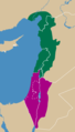 first draft


- Article(s)
- Levantine Arabic
 , currently FAC
 - Request
- Hi everyone,
- Could someone vectorize this map please? :) (As suggested by Nehme1499 in the FAC nomination) The legend may be removed so that the map can be reused in other languages. The current colors are fine for me but feel free to change them.
- Ethnologue ("the standard reference" in linguistics) is the main source:
- Map of Syria and Jordan, Ethnologue
- Lebanon, Ethnologue: "Widespread" for the location of North Levantine
- Israel, Ethnologue: "Widespread" for the location of South Levantine
- Turkey, Ethnologue: "Adana, Hatay, and Mersin provinces" for the location of North Levantine
- Map of Turkey, Ethnologue
- Turkey: Map 16.1 in Brustad and Zuniga, Levantine Arabic
- Turkey: Map 9.2 (p. 259) in Prochazka, Northern Fertile Crescent
- Turkey: Encyclopedia of Arabic Language and Linguistics: "The Arabic dialects of Cilicia (Southern Turkey) are spoken in the three large cities of the Cilician Plain (Çukurova), namely Adana, Tarsus, and Mersin, as well as in about 25 villages situated to the south of these towns (see map)."
- Basically, all of Israel and Palestine = South Levantine. All of Lebanon = North Levantine. For Jordan (South Levantine) and Syria (North Levantine), Ethnologue's map is the reference = same as the current image. For Turkey, the border in the current image is okay (it's the same as the one used in Brustad and Zuniga). If a passionate editor wants to improve the accuracy of the map in Turkey then the map from Prochazka could be used instead. An alternative could be to use stripes in Turkey instead, to show that in this area North Levantine Arabic cohabitates with Turkish. But this is not necessary at all, a simple vectorization of the current image would already be amazing!
- Thanks for any help you can provide,
- A455bcd9 (talk) 10:23, 29 March 2022 (UTC)
- Discussion
@A455bcd9: The links to Lebanon, Israel and Turkey require a subscription to Ethnologue. M.Bitton (talk) 11:40, 29 March 2022 (UTC)
- @M.Bitton, yes I have a subscription. If you need it I can send you the PDF version of the page by email. A455bcd9 (talk) 12:00, 29 March 2022 (UTC)
- @A455bcd9: A direct link to the maps (like the one for the map of Turkey) would probably be enough. Incidentally, the current map shows that Levantine Arabic is spoken in Turkey in an area that stretches all the way to Tarsus, while the linked map doesn't specify any particular area. Do you have any idea which source was used for the former? M.Bitton (talk) 16:37, 29 March 2022 (UTC)
- @M.Bitton: Heh. I had already started on this one -- Guerillero Parlez Moi 17:16, 29 March 2022 (UTC)
- @Guerillero: In that case, you might as well finish it. M.Bitton (talk) 20:50, 29 March 2022 (UTC)
- @M.Bitton: there's no equivalent map for Lebanon, Israel, and Palestine unfortunately, that's why I only posted links to the text description which says that Levantine is "widespread" there, i.e. present all over the country. This is what the current map shows and what Brustad and Zuniga show in their map as well.
- Regarding Turkey, as I mentioned, the current map follows Brustad and Zuniga's map (or at least tries to, I haven't compared them side by side to check that the areas were exactly identical). Ethnologue's map isn't accurate enough and their text description says "Adana, Hatay, and Mersin provinces" for the location of Levantine in Turkey, even though Levantine speakers are only present in parts of these provinces. An even more accurate map is available in Prochazka's article. But again, the current map is fine and could simply be vectorized as is.
- @Guerillero: thanks a lot for your help! Please let me know if you have any question. A455bcd9 (talk) 06:43, 30 March 2022 (UTC)
- You can find Brustad and Zuniga's map p. 404 on Google Books here.
- And Prochazka's map on Google Books as well p. 259 here.
- Because of Google Books' limitations I recommend you take a screenshot as soon as you get the map because it may then not be available anymore.
- Otherwise please let me know and I'll send you the full articles by email.
- (but again, the current map should be fine) A455bcd9 (talk) 06:51, 30 March 2022 (UTC)
- @A455bcd9: Can you please send the articles to tfish
 guerillero.net -- Guerillero Parlez Moi 16:11, 30 March 2022 (UTC)
- @Guerillero: done! Thanks for your help :) A455bcd9 (talk) 16:38, 30 March 2022 (UTC)
- @A455bcd9: How does this look to you? -- Guerillero Parlez Moi 23:34, 30 March 2022 (UTC)
- Thanks a lot: it looks great!
- You used a dashed line for Palestine (Gaza and West Bank): that's fine for me but is that the convention on Wikipedia? (vs a solid line) You displayed the Golan Heights as part of Israel. This area is internationally recognized as Syrian territory occupied by Israel. Would it be better to use a dashed line there as well? But again, there may be a convention on Wikipedia regarding this point?
- Regarding the colors, I wouldn't use green because it is associated with Islam and the Arabic language in general. Could you use another color for North Levantine? (no idea which one, I'm colorblind so I trust you on this choice...)
- I think it would be good to display the whole Syria and the whole Jordan on the map, to clearly show that Levantine isn't spoken in the rest of their territory. So could you "extend" the map on the right/east a bit? And maybe include the whole Cyprus as well? (just for aesthetics haha) A455bcd9 (talk) 09:28, 31 March 2022 (UTC)
- So according to Status of the Golan Heights:
In 2019, the United States became the only state to recognize the Golan Heights as Israeli sovereign territory, while the rest of the international community continues to consider the territory Syrian held under Israeli military occupation.
- I saw that you wrote that "The international boundaries are from the United States Department of State and are for identification only. They do not make a claim of de facto or de jure control of any piece of territory." But here I think it's problematic and it would be better either to use a dotted line for the Syrian-Israeli border in the Golan or to include the Golan Heights as part of Syria. A455bcd9 (talk) 09:36, 31 March 2022 (UTC)
- I agree with all of A455bcd9's considerations above. Dotting both the Syrian and Israeli borders of the Golan Heights seems to be the solution Google Maps is going with (other maps online only dot the Israeli border, and have no border on the Syrian side). Also, can't we use gray instead of brown (as it seems to be the default colour in Wikipedia maps, for e.g. here), and replace green and purple with orange and blue? I think those colours would be a better fit. Nehme1499 11:13, 31 March 2022 (UTC)
- Yes, another solution may be to dot both the Israeli and the Syrian borders. But looking at the map you've just sent, the Golan Heights are shown as part of Syria, and there's no dots either in Palestine. File:ISR orthographic.svg (in Israel) and File:Syria (orthographic projection).svg (in Syria) show the Golan as parts of Syria and don't dot Palestine. So that's maybe the standard/convention on Wikipedia? A455bcd9 (talk) 11:24, 31 March 2022 (UTC)
- That seems to be the case. As long as we are consistent with other maps on Wikipedia it's fine by me. The main points are displaying all of Syria, Jordan and Cyprus in the map, and changing brown, green and purple to other colours (gray, orange and blue?). Nehme1499 12:45, 31 March 2022 (UTC)
- Other maps such as this, this and this also have solid borders for Palestine, and strictly include the Golan Heights in Syrian territory. 12:58, 31 March 2022 (UTC)
- Yes, another solution may be to dot both the Israeli and the Syrian borders. But looking at the map you've just sent, the Golan Heights are shown as part of Syria, and there's no dots either in Palestine. File:ISR orthographic.svg (in Israel) and File:Syria (orthographic projection).svg (in Syria) show the Golan as parts of Syria and don't dot Palestine. So that's maybe the standard/convention on Wikipedia? A455bcd9 (talk) 11:24, 31 March 2022 (UTC)
- I agree with all of A455bcd9's considerations above. Dotting both the Syrian and Israeli borders of the Golan Heights seems to be the solution Google Maps is going with (other maps online only dot the Israeli border, and have no border on the Syrian side). Also, can't we use gray instead of brown (as it seems to be the default colour in Wikipedia maps, for e.g. here), and replace green and purple with orange and blue? I think those colours would be a better fit. Nehme1499 11:13, 31 March 2022 (UTC)
- So according to Status of the Golan Heights:
- @A455bcd9: How does this look to you? -- Guerillero Parlez Moi 23:34, 30 March 2022 (UTC)
- @Guerillero: done! Thanks for your help :) A455bcd9 (talk) 16:38, 30 March 2022 (UTC)
- @A455bcd9: Can you please send the articles to tfish
- @Guerillero: In that case, you might as well finish it. M.Bitton (talk) 20:50, 29 March 2022 (UTC)
- @M.Bitton: Heh. I had already started on this one -- Guerillero Parlez Moi 17:16, 29 March 2022 (UTC)
- @A455bcd9: A direct link to the maps (like the one for the map of Turkey) would probably be enough. Incidentally, the current map shows that Levantine Arabic is spoken in Turkey in an area that stretches all the way to Tarsus, while the linked map doesn't specify any particular area. Do you have any idea which source was used for the former? M.Bitton (talk) 16:37, 29 March 2022 (UTC)
- What do you think about these colors @Nehme1499:? A455bcd9 (talk) 13:00, 31 March 2022 (UTC)
- I like them, and dark blue vs light blue seems to be quite common on Wikipedia. My only slight concern is that some readers might make the association of dark blue = more spoken, light blue = less spoken. Nehme1499 13:03, 31 March 2022 (UTC)
- Anyway, that Facebook map is another example of using gray as a "neutral" colour, as opposed to brown. Nehme1499 13:03, 31 March 2022 (UTC)
- You're right, dark blue vs light blue may imply this meaning (as it is the case on this map, showing countries were Facebook used to be banned vs where it is currently banned). A455bcd9 (talk) 13:26, 31 March 2022 (UTC)
- I notice that the border between Israel and Lebanon is also in dashed line. Should be solid as well. A455bcd9 (talk) 19:01, 2 April 2022 (UTC)
- @Nehme1499: I tried this (with my poor Inkscape skills...): File:Levantine Arabic red blue.svg. What do you think? A455bcd9 (talk) 09:44, 4 April 2022 (UTC)
- @A455bcd9: Very nicely done! I think we can start using that version in the article. Nehme1499 10:46, 4 April 2022 (UTC)
- I'm not sure keeping blue (Jewish) is ideal (especially given its inclusion of Israel), for the same logic of not wanting green (Islam). Something like pink/purple and orange could work. Nehme1499 10:52, 4 April 2022 (UTC)
- You're right. I changed the colors. Look at that: Levantine Arabic ;) A455bcd9 (talk) 11:27, 4 April 2022 (UTC)
- The request is done. Thanks a lot to @Guerillero for his help! Final version of the map: File:Levantine Arabic 2022.svg. A455bcd9 (talk) 08:26, 5 April 2022 (UTC)
- You're right. I changed the colors. Look at that: Levantine Arabic ;) A455bcd9 (talk) 11:27, 4 April 2022 (UTC)
- @Nehme1499: I tried this (with my poor Inkscape skills...): File:Levantine Arabic red blue.svg. What do you think? A455bcd9 (talk) 09:44, 4 April 2022 (UTC)
- I notice that the border between Israel and Lebanon is also in dashed line. Should be solid as well. A455bcd9 (talk) 19:01, 2 April 2022 (UTC)
- You're right, dark blue vs light blue may imply this meaning (as it is the case on this map, showing countries were Facebook used to be banned vs where it is currently banned). A455bcd9 (talk) 13:26, 31 March 2022 (UTC)
Madonna map
-
 Description of first image

- Article(s)
- Cultural impact of Madonna
- Request
- Please colored India in blue (specifically #00acbf) -- Apoxyomenus (talk) 17:54, 10 April 2022 (UTC)
- Discussion
US Map with states with abortion trigger laws

- Article(s)
- Abortion in the United States
- Abortion in the United States by state
- Request
- Hi i am just wondering can sombody make a US map with states with abortion trigger laws. here are sources.
[1][2] Thanks. La lopi (talk) 07:50, 4 May 2022 (UTC)
References
- Discussion
 Request taken by M.Bitton (talk) 17:10, 4 May 2022 (UTC).
- Done M.Bitton (talk) 22:37, 4 May 2022 (UTC)
- Thank you M.Bitton. La lopi (talk) 03:21, 5 May 2022 (UTC)
{{resolved}}
ENTSO-E map

- Article(s)
- ENTSO-E, Electric power transmission, Electrical grid
- Request
- Ukraine and Moldova added: https://www.entsoe.eu/news/2022/03/16/continental-europe-successful-synchronisation-with-ukraine-and-moldova-power-systems/ -- Fixmaster (talk) 14:52, 16 March 2022 (UTC)
- More: https://ec.europa.eu/commission/presscorner/detail/en/statement_22_1789?fbclid=IwAR3RbYqd4MG-KLEYo6tLBFEg3dK3GkAB-lbghatPcrdZI7LWn_bPs4sQ5ws -- Fixmaster (talk) 16:23, 16 March 2022 (UTC)
- Discussion
@Fixmaster: What part of the map needs fixing? M.Bitton (talk) 17:00, 16 March 2022 (UTC)
- @M.Bitton: Somebody already colored Ukraine and Moldova now. Probably nothing else is needed. Well, maybe Crimea, as it's Russian occupation, needs to be decolored or something. No idea about this one. It's powered from Russia proper. Fixmaster (talk) 18:05, 16 March 2022 (UTC)
- @M.Bitton: Just saw this - "United Kingdom" needs changing to "Great Britain" Chidgk1 (talk) 15:18, 21 April 2022 (UTC)
Request Map for Canadian uranium mines
- Article(s)
- Draft:Uranium mining in the Elliot Lake area
- Request
I would be very happy if anyone could make me a map that I could use on wikipedia that is basically like Figure 1 available for free download from https://papers.acg.uwa.edu.au/p/1915_92_Berthelot/
CT55555 (talk) 22:47, 23 April 2022 (UTC)
- Discussion
Map of Europe
{{resolved}}
-
 Completed request

.svg)
- Article(s)
- Politics of Europe
- Request
- Hi i am just wondering can sombody make a Map of Europe with each nation coloured in by the % of the vote the governing party got during the last election. The higher the % The Darker the color while the lower the % more lighter. Here is the list.
1. Hungary 54.01% 2. Moldova 52.80 3. Kosovo 50.28 4. Albania 48.67 5. Poland 43.6% 6. UK 43.6% 7. Ukraine 43.16% 8. Serbia 42.91 9. Portugal 41.4% 10. Greece 39.85% 11. Austria 37.5% 12. Croatia 37.26 13. Macedonia 35.89% 14. Estonia 28.8% 15. Sweden 28.3% 16. Spain 28.0% 17. Czech republic 27.8% 18. Norway 26.3% 19. Denmark 25.9% 20. Lithuania 25.77 21. Germany 25.7%, 22. Bulgraia 25.3% 23. Romanina 25.18 24. Slovkia 25.02% 25. Slovenia 24.92% 26. Ireland 22.2% 27. Netherlands 21.9% 28. Finland 17.7% 29. Belgium 8.54% 30 Latvia 6.7% Thanks. La lopi (talk) 07:41, 7 April 2022 (UTC)
- Discussion
- Hello La lopi,
is there a specific colour scheme you desire for this map? I have all the data ready and a map created. — Berrely • Talk∕Contribs 18:55, 9 April 2022 (UTC)- Ah nevermind, it seems there are conventions. — Berrely • Talk∕Contribs 18:55, 9 April 2022 (UTC)
- Looks good, i was thinking it might be right to add Russia and Iceland in the map, Russia's governing party United Russia has 49.8% and Iceland's governing party has 12.57%.La lopi (talk) 03:36, 10 April 2022 (UTC)
- Hi just wondering what do you think???La lopi (talk) 04:26, 9 May 2022 (UTC)
- La lopi, I have completed your request, but I would like to say a few things. First, please make sure to provide sources (i.e. URLs) for these figures. I will not do any further maps for you if you do not. Others have highlighted how you had a completely incorrect value from Belgium, which doesn't even have a governing party. Also, as these maps take a lot of time to make, please make sure to actually use them instead of letting them sit dormant. I hope you like the map! — Berrely • Talk∕Contribs 20:45, 10 June 2022 (UTC)