Hi! I'm an Italian student in Erasmus for the sommer semester 2019 at Albert-Ludwigs Universität in Freiburg. On my page you can find all my translation done during my language course. I published my first Wikipedia page, you can find the page here: Temple of Santo Stefano della Vittoria. You can also find my professor's page here: Alison Nagel.
Timeline edit
Weekly Progess edit
| 24.04.19 | After course introduction, created my own Wikipedia account and started my first translation: section 3 of the Hiddensee article (you can find the article's link on my professor's page); | 90 min. |
| 08.05.19 | After comparing and correcting my translation, started translating section 7 (it can also be seen on Chiara's page).; | 90 min. |
| 15.05.19 | We compared, corrected and published the translation of section 7. | 90 min. |
| 29.05.19 | Started a new translation of an untranslated Wikipedia page, Tempio di Santo Stefano della Vittoria, from Italian to English | 90 min. |
| 05.06.19 | We compared, corrected and published the translation of Tempio di Santo Stefano della Vittoria | 90 min. |
| 19.06.19 | After taking a look at the Home assignment corrections, I started a new translation "Schloss Binningen (Schweiz)". | 90 min. |
| 26.06.19 | After taking a look at the Home assignment corrections, we continued with the translation. | 90 min. |
| 03.07.19 | I had my presentation about the issues encountered while translating Wikipedia. | 90 min. |
| 10.07.19 | My classmates had their presentations. | 90 min. |
| 17.07.19 | After the last presentations, I had a general review of my translations. | 90 min. |
| 24.07.19 | It was my last lesson, and i published my first Wikipedia page Temple of Santo Stefano della Vittoria. | 90 min. |
Section 3 edit
Settlements edit
Grieben edit
Grieben ist der nördlichste Ort auf der Insel. Sein Name (abgeleitet vom slawischen Wort für Pilz) deutet darauf hin, dass der Ort eine der beiden Siedlungen auf der Insel war, die bereits zu slawischer Zeit vor der Ankunft der deutschen Mönche im 13. Jahrhundert existierten. Zu Zeiten der Existenz des Klosters wurden für Grieben acht Katen genannt. Die Zahl der Häuser hat sich bis zur Neuzeit kaum verändert.[1]
Grieben is the northernmost place on the island. Its name (derived from slavic word for "fungus") indicates that Grieben was one of the two settlements on the area that already existed during the slavic period before the arrival of the German monks in the 13th century. At the time of the existence of the monastery, Grieben was in possession of eight cottages. The number of houses has barely changed up until the modern era. [1]
Kloster edit
Der Ort entstand um das Ende des 13. Jahrhunderts gegründete Kloster Hiddensee. Ende des 19. Jahrhunderts bestand er nur aus Kirche, Gutshaus, Pfarr- und Schulhaus und zwei Arbeiterhäusern und wuchs erst danach zu seiner heutigen Größe.[2] Hier siedelten sich eine Reihe von Künstlern an, bekannt ist Kloster als Wohnort von Gerhart Hauptmann geworden, der auf dem dortigen Inselfriedhof begraben wurde.
This settlement was founded around the Hiddensee monastery at the end of the 13th century. At the end of the 19th century it consists only of the church, rectory, school, and two council houses and grew only afterwards to its current extent. [3] Here settled a number of artists. Gerhart Hauptmann's residence became the monastery, and he was also buried there in the island churchyard.
Vitte edit
Vitte wurde erst 1513 urkundlich erwähnt. Der Name leitet sich von einem Gattungsnamen ab, dem niederdeutschen Wort für eine Niederlassung von Heringsfischern. Vitte wurde bald der größte Ort der Insel und ist es bis heute.[1]
Vitte was first documented as a village in year 1513. The name derives from a generic name, namely the low German word for an establishment of herring fishermen. Vitte soon became the biggest settlement of the island and remains today.[1]
Glambeck edit
Neben Grieben war Glambeck eine der beiden zu slawischer Zeit existierenden Siedlungen der Insel, der Name leitet sich von tiefer Ort ab. Bereits vor 1700 wurde der Ort zur Wüstung. Heute erinnert ein Flurname für ein Landstück etwa einen Kilometer nördlich von Neuendorf an den Ort.[1]
Alongside Grieben, Glambeck was one of the two existing Slavic settlements of the island, the name derives from "deep place". Already before 1700, the settlement became an abandoned land. Today, a field name at approximately one kilometre north from Neuendorf is a reminder of Glambeck.[1]
Neuendorf edit
Der Ort entstand um das Jahr 1700, vermutlich als Ersatz für das aufgebene Dorf Glambeck. Hier hat sich der Charakter des alten Fischerdorfes am stärksten auf der Insel erhalten. Seine Bebauungsstruktur mit Häusern auf gemeinschaftlich genutztem Wiesengelände ohne angelegte Wege gilt als einmalig, der Ort steht als Ganzes unter Denkmalschutz.
The place emerged around 1700, probably as a replacement for the deserted village Glambeck. Here the character of the fishing village has been kept strong on the island. Its building structure with houses at commonly used meadows without paws is classified as unique, and the place also stands entirely under monument conservation.
Plogshagen edit
Plogshagen ist eine Gründung aus Zeiten der Kolonisation durch deutsche Siedler nach Klostergründung. Der Name leitet sich vermutlich vom Personennamen Plog ab.[1] Heute ist Plogshagen weitgehend mit Neuendorf zusammengewachsen.
Plogshagen is an establishment from times of the colonization by German settlers after monastery establishment. The name is probably derived from the family name Plog.[1] Today Plogshagen is growing together largely with Neuendorf.
Part of Section 7 edit
(Giuseppe)
Neun Gräber fanden sich nördlich der Klosterkirche und eines im Kreuzgang östlich des Westflügels der Klausur. Bettina Jungklaus untersuchte die Skelette der sieben männlichen und zwei weiblichen Erwachsenen sowie eines jungen Mädchens anthropologisch. Ein 20- bis 30-jähriger Mann wies eine verheilte Hiebverletzung am rechten Stirnbein auf. Es gab eine gemeinsame Bestattung eines 50–60 Jahre alten Mannes mit einem 14–15-jährigen Mädchen, bei der der Mann mit seiner rechten Hand den linken Arm der Jugendlichen umfasst hielt. Die Krankheitsbelastung war auffallend niedrig. Am häufigsten konnten Zahnstein und Parodontose festgestellt werden. Karies fand sich nur an einem Gebiss, was für mittelalterliche Bevölkerungen ungewöhnlich wenig war.[4][5]
Nine graves were found to the north of the monastic church and one in the cloister to the east of the west wing of the confinement. Bettina Jungklaus anthropologically examined the skeletons of seven male and two female adults as well as a young girl. A 20-30 year old man showed a healed up clout violation in the right frontal bone. There was a common burial containing a 50-60 year old man and 14-15 year old girl. The man holds the girl with his right hand by her left arm in an embrace. The stress of disease was remarkably low. Most frequently tartar and periodontosis could be found. Caries were found only in one set of teeth, and that was for medieval populations particularly uncommon.[6][7]
Tempio di Santo Stefano della Vittoria edit
Il tempio di Santo Stefano della Vittoria è un edificio sacro che si trova in località Pozzo della Chiana a Foiano della Chiana, in provincia di Arezzo.
The Temple of Santo Stefano della Vittoria is a holy building located in Pozzo della Chiana, which is a small village near Foiano della Chiana in the province of Arezzo.
Il tempio edit
Questo tempietto dedicato alla Vittoria venne fatto costruire dal granduca Cosimo I de' Medici presso la piana di Scannagallo, dove (1554) le truppe della coalizione imperiale sconfissero quelle franco-senesi nella Battaglia di Scannagallo, durante la Guerra di Siena.
Il tempio è tradizionalmente attribuito a Bartolommeo Ammannati, ma è stato recentemente riconnesso alla collaborazione professionale tra Giorgio Vasari e l'Ammannati stesso. L'edificio venne realizzato nel 1569 sulla base di una planimetria ottagona con scarsella di matrice tipicamente fiorentina utilizzando una serie di motivi decorativi di matrice antiquaria.
In linea con le più aggiornate sperimentazioni manieristiche si mostra l'uso dell'ordine dorico, posto a scandire i pilastri esterni.
Sopra il frontone della porta principale è collocato un grandioso stemma in travertino di casa Medici, recante l'iscrizione latina del suo nuovo titolo. Sulla porta all'interno si vede lo stemma della famiglia Gianfigliazzi. Le pareti laterali mostrano due epigrafi in lingua latina dedicate all'istituzione dell'ordine dei Cavalieri di Santo Stefano, istituito a Pisa nel 1561, fondato dal duca (già Gran Maestro) con il fine di proteggere le acque del Tirreno dai Corsari barbareschi[8], a cui il tempio stesso venne donato.[9]
Nel 1565 le galee dei cavalieri di Santo Stefano parteciparono alla spedizione in difesa di Malta.
Nel 1571, dopo la grave sconfitta di Venezia in seguito alla perdita di Cipro occupata dai Turchi, per fronteggiare il pericolo della loro espansione nelle coste e nelle isole dell'Europa occidentale, il papa Pio V riuscì a promuovere una difficile alleanza coinvolgendo le maggiori potenze marittime europee nella costituzione della Lega Santa.[10] La Lega con a capo l'ammiraglio Don Giovanni d'Austria era formata da galee spagnole, veneziane, genovesi e galee della flotta pontificia. Quest'ultima, posta sotto il comando di Marcantonio Colonna, comprendeva galee armate dalle signorie toscane[11] con a bordo equipaggi dei cavalieri di Santo Stefano.
The small temple is dedicated to Victoria, who is the personified goddess of victory and the Roman equivalent of the Greek goddess Nike. The temple was built by Grand Duchy of Tuscany Cosimo I de Medici on the plain of Scannagallo, where (in 1554) the troops of the Imperial Coalition defeated the French-Senese troops in the Battle of Scannagallo, during the War of Siena.
The construction of the temple is traditionally attributed to the Italian architect and sculptor Bartolommeo Ammannati, but has recently been linked to the professional collaboration between two Italian artists, Ammannati himself and Giorgio Vasari. It was built in 1569 on the form of an octagonal planimetry with a typically Florentine apse, and it also includes a series of ancient ornaments.
The use of Doric order is in line with the latest European art style of Mannerism. It also articulates the exterior columns of the temple.
The frontal pediment contains the House of Medici coat of arms, and it also contains the Latin script of the new family title.
Inside the temple, above the door, you can see the Gianfigliazzi family coat of arms. On the walls, there are two Latin epigraphs dedicated to the institution Ordine dei Cavalieri di Santo Stefano, founded in Pisa in 1561 by the Duke (already Grand Master), with the purpose of protecting the Tyrrhenian Sea from Barbary pirates[12], to whom the temple was previously donated.[13]
In 1565 the Cavalieri di Santo Stefano Galleys participated in an expedition to defend Malta.
In 1571, Venice suffered a serious defeat, due to the loss of Cipro, that was occupied by Turks. Pope Pio V established a difficult alliance involving the major European maritime powers, creating the Holy League[14], in order to deal with the danger of the Turks´ expansion along the coast and islands of Western Europe. Spanish, Venetian and Genoese Galleys, as well as the pontifical naval fleet formed the League, led by the Admiral Don Giovanni d'Austria. The pontifical naval fleet, captained by Marcantonio Colonna, was composed of galleys armed by the Tuscan Signoria [15] , crewed by Cavalieri di Santo Stefano.
Note edit
- ^ a b c d e f g h Arnold Gustavs: Die Insel Hiddensee. Ein Heimatbuch. Carl Hinstorff Verlag, Rostock 1953, S. 37–39.
- ^ Arnold Gustavs: Die Insel Hiddensee. Ein Heimatbuch. Carl Hinstorff Verlag, Rostock 1953, S. 81.
- ^ Arnold Gustavs: Die Insel Hiddensee. Ein Heimatbuch. Carl Hinstorff Verlag, Rostock 1953, S. 81.
- ^ Bettina Jungklaus (2010), Landesamt für Bodendenkmalpflege Mecklenburg-Vorpommern und Archäologischen Landesmuseum (ed.), "Anthropologische Untersuchungen an zehn Skeletten vom Gelände des Zisterzienserklosters Hiddensee", Bodendenkmalpflege in Mecklenburg-Vorpommern: Jahrbuch (in German), vol. 57, Lübstorf, pp. 359-368, ISSN 0947-3998
- ^ "Projekt Hiddensee, Zisterzienserkloster". anthropologie-jungklaus.de. Retrieved 2017-06-04.
{{cite web}}: Cite has empty unknown parameters:|day=,|month=, and|deadurl=(help) - ^ Bettina Jungklaus (2010), Landesamt für Bodendenkmalpflege Mecklenburg-Vorpommern und Archäologischen Landesmuseum (ed.), "Anthropologische Untersuchungen an zehn Skeletten vom Gelände des Zisterzienserklosters Hiddensee", Bodendenkmalpflege in Mecklenburg-Vorpommern: Jahrbuch (in German), vol. 57, Lübstorf, pp. 359-368, ISSN 0947-3998
- ^ "Projekt Hiddensee, Zisterzienserkloster". anthropologie-jungklaus.de. Retrieved 2017-06-04.
{{cite web}}: Cite has empty unknown parameters:|day=,|month=, and|deadurl=(help) - ^ G. Spini, Disegno storico della Civiltà Italiana, Roma, 1958
- ^ Ibidem, p.162.
- ^ F. Palmieri, Op, Cit, p.142.
- ^ G. Spini, Disegno storico della Civiltà Italiana, Roma, 1958
- ^ G. Spini, Disegno storico della Civiltà Italiana, Roma, 1958
- ^ Ibidem, p.162.
- ^ F. Palmieri, Op, Cit, p.142.
- ^ G. Spini, Disegno storico della Civiltà Italiana, Roma, 1958
Voci correlate edit
Altri progetti edit
Collegamenti esterni edit
Stefano della Vittoria (Foiano) Categoria:Architetture di Bartolomeo Ammannati
Schloss Binningen (Schweiz) edit
Das Schloss Binningen ist ein Schloss im Zentrum der basellandschaftlichen Gemeinde Binningen bei Basel. Heute beherbergt das Schloss ein Restaurant mit Hotel. Ursprünglich war die Anlage als Weiherschloss ausgelegt, allerdings wurde das Gewässer 1772 zugeschüttet.
Binningen Castle is located in the heart of the basel landscape municipality of Binningen near Basel. Today the castle accomodates a restaurant with a hotel. Originally the complex was designed as a pond castle, but the watercourse was filled up in 1772.
Lage und Beschreibung / Location and description edit
Das Schloss Binningen liegt heute in einem kleinen Park direkt an der Strassenbahnlinie nach Basel. Das Schloss ist ein rechteckiger Bau mit einem Innenhof. An der südöstlichen Ecke erhebt sich ein kleiner Rundturm, auf der Ostseite befindet sich heute die Aussenterrasse des Restaurants. Die Aussenfassade ist in weiss gehalten, einzig die Fenster sind mit rotem Sandstein umgeben.
The Binningen Castle is located today in a small park directly on the tram line to Basel. The castle is a rectangular building with an inner courtyard. At the southeastern corner, there is a small round tower, on the east side, there is currently the outdoor terrace of the restaurant. The outer facade is white, only the windows are surrounded by red sandstone.
Geschichte / History edit
Es wird heute angenommen, dass das Schloss im Jahre 1293 vom Basler Bürger Heinrich von Zeise als Weiherschloss erbaut wurde.[1] Das Basler Erdbeben im Jahre 1356 liess einzig noch die Grundmauern des Schlosses stehen. 1409 brannte das Schloss zur Ruine ab. 10 Jahre später baute man es wieder auf, 1444 wurde es während des St. Jakobskrieges von den Habsburgern wieder zerstört. Weil um die Jahre 1520 der Kanton Solothurn Interesse am Dorf und am Schloss zeigte, entschloss sich ein Ratsmitglied der Stadt Basel das Anwesen zu kaufen, um damit die Gefahr einer Solothurner Expansion «vor die Haustüren» zu stoppen. Je nach Bedarf wurde das Schloss nun als Vorposten von Basler Truppen verwendet. Es gehörte nacheinander den Familien Grieb und Escher vom Glas. 1545 kauften Joachim van Berchem und Johann von Brügge das Anwesen der Stadt ab. Wie später festgestellt wurde, war der Herr von Brügge kein Geringerer als David Joris, ein Täuferführer, der in Basel unter einem falschen Namen lebte. 1574 wechselte der Besitz des Schlosses an Nikolaus von Hatstatt, der das Schloss nach seinem Tod wiederum an die Stadt Basel weitervererbte. Nachdem die Stadt das Schloss einige Jahre lang verpachtet hatte, wurde es zuerst an die Familie Eckstein verkauft, bis es 1613 in die Hände der Grafen von Sulz aus Württemberg fiel. Danach folgten Georg Willhelm von Freudenstein und der Freiherr von Polheim als Eigentümer. 1772 wurde der Weiher rund um das Schloss trockengelegt. Im Jahr 1817 wurde das Schloss an Niklaus Singeisen aus Liestal veräussert, der dort ein Casino einrichten wollte, das Projekt wurde allerdings von einem benachbarten Gastwirt verhindert. 1870 eröffnete erstmals ein Restaurant im Schloss. Es folgten zahlreiche Umbauten, bis 1960 die Gemeinde Binningen das Schloss kaufte.
Nowadays, it is supposed that the castle was built in 1293 by the Basel citizen Heinrich von Zeise as a pond castle.[2] The Basel earthquake of 1356 left only the foundation walls of the castle standing. In 1409 the castle burned down to ruin. It was rebuilt 10 years later and destroyed again by the Habsburgs during the St. James' War in 1444. As around 1520 the canton of Solothurn showed interest in the village and the castle, a council of the city of Basel decided to buy the property in order to prevent the risk of Solothurn's expansion "on its doorstep". The castle was now used as an outpost by Basel troops as needed. It belonged successively to the Grieb and Escher vom Glas families. In 1545 Joachim van Berchem and Johann von Brügge bought the property from the city. As was later established, the Lord of Bruges was no less than David Joris, an Anabaptist leader who lived in Basel under a false name. In 1574 the possession of the castle was transferred to Nikolaus von Hatstatt, who after his death passed the castle on to the city of Basel. After the town had rented the castle for several years, it was first sold to the Eckstein family until it fell into the hands of the Counts of Sulz from Württemberg in 1613. Georg Willhelm von Freudenstein and the Baron von Polheim succeeded as owners. In 1772 the pond around the castle was drained. In 1817 the castle was sold to Niklaus Singeisen from Liestal, who wanted to set up a casino there, but the project was prevented by a neighbouring innkeeper. In 1870 a restaurant was opened in the castle for the first time. Numerous renovations followed until the municipality of Binningen bought the castle in 1960.
-
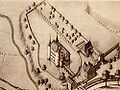 Das Schloss im Jahr 1660, Aquarell von Albrecht Knauw - The Castle in yhe year 1660, Watercolors by Albert Knauw
 -
 Das Schloss im Jahr 1760, Zeichnung von Emanuel Büchel - The Castle in the year 1760, Drawing from Emanuel Büchel
 -
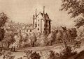
 Das Schloss im Jahre 2006 vor einem zweimaligen Umbau - The castle in the year 2006 before a double reconstruction


Literatur edit
- Werner Meyer: Burgen von A bis Z – Burgenlexikon der Regio. Herausgegeben von den Burgenfreunden beider Basel aus Anlass ihres 50-jährigen Bestehens. Druckerei Klingental, Basel 1981, S. 82–83.
- Werner Meyer: Burgen von A bis Z - Burgenlexikon der Regio. Published by Burgenfreunde both of Basel on the occasion of their 50th anniversary. Druckerei Klingental, Basel 1981, pp. 82-83.
Weblinks edit
- Offizielle Website vom Restaurant und Hotel Schloss Binningen
- Burgenwelt: Schloss Binningen
- Das Schloss Binningen auf swisscastles.ch
- Schloss Binningen
Einzelnachweise edit
de:Vorlage:Navigationsleiste Burgen und Schlösser im Kanton Basel-Landschaft
Binningen, Schloss Kategorie:Binningen Kategorie:Kulturgut von regionaler Bedeutung im Kanton Basel-Landschaft Binningen #Schweiz