This article is within the scope of WikiProject International relations, a collaborative effort to improve the coverage of International relations on Wikipedia. If you would like to participate, please visit the project page, where you can join the discussion and see a list of open tasks.International relationsWikipedia:WikiProject International relationsTemplate:WikiProject International relationsInternational relations articles
Latest comment: 18 years ago3 comments2 people in discussion
I think it should be made clear in the article that the macroregions and subregions in this scheme were devised purely for statistical convenience, and are simply an arbitrary division of the world that facilitates statistical analysis. A full explanation is at [[1]]), NB especially the following statements:
The designations employed and the presentation of material at this site do not imply the expression of any opinion whatsoever on the part of the Secretariat of the United Nations concerning the legal status of any country, territory, city or area or of its authorities, or concerning the delimitation of its frontiers or boundaries.
The assignment of countries or areas to specific groupings is for statistical convenience and does not imply any assumption regarding political or other affiliation of countries or territories by the United Nations.
Also, as far as I can see, the term used by the UN to refer to this scheme is 'Standard country or area codes and geographical regions for statistical use', not 'UN geoscheme', so I'm wondering why the article has that title. Dougg00:48, 30 July 2006 (UTC)Reply
The term 'UN geoscheme' is an in-house invention here at Wikipedia. This year has seen a long-running battle over the meaning of 'America' and the definition of 'North America', and related matters about continents and 'regions'. Like, is Mexico part of North America or Central America?
It seemed simplest just to take whatever the UN seemed to be saying, and refer to that as their POV. One day Israel is 'racist', the next day they're not, depends the General Assembly resolution on "Zionism is Racism". --Uncle Ed01:02, 30 July 2006 (UTC)Reply
Okay, fair enough about 'geoscheme'. But surely the scheme presented here is not what the UN is saying, but is just one scheme that they use, this one being designed for statistical purposes? I think the article should make that clear, otherwise (as has happened in another article) people will get upset, thinking the UN is imposing a particular regional division on the world. Dougg07:42, 30 July 2006 (UTC)Reply
WHO gave these people the right to use the UN model as a standard
Latest comment: 16 years ago1 comment1 person in discussion
First of all we dont even know where the borders go between europe and asia as they are not official, thats why we dont even know which countries are transcontinental, which are completely european or not european at all. I understand that many people rely too much on the UN classification which is absolutely not correct. even though the UN has the power to recognize the borders of a sovereign state (in case of consensus among the majority of the member states) they have nothing to do with defining borders between the continents or inside a continent.WHat these borders are, is that they were created as an administrative entitiess for THE UN, and for the Functioning of the UN and thats exactly according to what they have different parts in the organization that have to "take care" of particular regions. There are many other organization who have devided continents or some regions with their own version of borders which does not mean that they are official, its purely for their organizational functioning. if the UN will call the council session where majority of the countries in the world/continent will agree on where borders go, in case of consencus(just like on this FORUM) they can make the borders official. Until then, if noone can provide any sources that says that the UN had a session where countries VOTED / AGREED on this issue, until there is a charter that says that the borders are official and etc.these borders do not set a standard for anyone in the world. they are purely for the UN in order to implement their administrative functions.(just like the US army has different commands that have to take care of particular region in the world.)
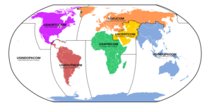
in this map all of those "transcontinental" countries are in the European command (which does not necesarily mean that they are european, though, because these are just the administrative entitys, for the functioning of the certain organization and etc. and nothing else)
Latest comment: 17 years ago1 comment1 person in discussion
This page links to the region and subregion pages, but those words are very general geographic terms, not UN geoscheme specific, as this page seems to imply. I've been adding to the region page to make it more about the general geographic concept of "region". The subregion page seems more confusing than useful, especially if it is meant to be UN geoscheme specific. Perhaps the links on this page ought to be changed to Region (UN geoscheme) and Subregion (UN geoscheme) -- that is, if the topics actually require pages. Why not just describe the whole thing here on the UN geoscheme page? ..in any case, the changes being made over at region are going to make this page's first link ("The UN geoscheme divides the world into "macro regions"...) into a kind of change of topic. Just saying... Pfly06:31, 24 October 2006 (UTC)Reply
Latest comment: 17 years ago1 comment1 person in discussion
Has anyone put this map together with labels in different languages? I'm using it in Campaigns Wikia, and we have 10 languages. I'd like to use the same map for each of our Voters Guide pages, but I need the labels in the local language instead of English. Can anyone help? Chadlupkes15:10, 27 November 2006 (UTC)Reply
Latest comment: 16 years ago3 comments2 people in discussion
The Subregion page was almost entirely about UN "subregions", part of the UN geoscheme as described here. But the term "subregion" means a lot more than that, and over time the content of "subregion" has creeped and become increasingly messy and confusing. As I wrote above, last October, I don't see why the UN subregion concept requires its own page. Why not address the topic here instead? Pfly08:16, 15 August 2007 (UTC)Reply
Actually, no: the 'subregion' article lists many sub/regions which may or may not equate with the subregions in this article. This article deals with a specific system (which is also used in various spots in Wikipedia), and I do not think the 'subregion' article (which is a far broader concept) has creeped so much that a merge is required. And even if that article does creep, what of it? After all, the concept of regions and subregions is somewhat tenuous, wherein the topic of this article is not. Quizimodo09:12, 15 August 2007 (UTC)Reply
I just didn't see the point of the subregion page at all. If subregions are a kind of region, then the page would make more sense being part of the region page. But since the subregion page was originally about the UN geoscheme subregion concept, I thought it should just be explained here instead of on its own page. In any case the subregion page is more confusing than helpful, whatever it is about. "Merging" with either this page or the region page would basically mean deleting the subregion page. Is there actually anything there that isn't already explained here or, thanks to creep, region? Anyway, it doesn't matter. Pfly15:19, 15 August 2007 (UTC)Reply
Latest comment: 16 years ago1 comment1 person in discussion
What was this geoscheme proposed/set into force? What is its evolution (if any)? Please don't answer me here, expand the article instead. `'Míkka>t00:05, 10 April 2008 (UTC)Reply
Why does this cold-war era classification system deserve a separate page? Merge
Latest comment: 11 years ago2 comments2 people in discussion
Czech Republic is in Eastern Europe while Austria, located almost on the same line, is somehow with the West? Clearly, the UN is still functioning as if we lived in 1950's and Eastern Europe was synonymous of communist, Soviet-allied countries. I see no other explanation. This classification is antiquated and it needs to be done away with. Given all this, why does it deserve a separate page? Should not it be merged with the UN or something related? Separate page gives an impression that it is something crucial and this might be the reason why the classification creates so many problems on various pages related to what I view as Central European countries --Bucharwm (talk) 02:26, 11 January 2011 (UTC)Reply
I asked the UN about the goescheme, because it seems totally ungeographic and a bit weird - the UK is far from Northern European culture and geography, Bulgaria is South European culturally and historically and so on. See the answer I got below.
--81.100.242.0 (talk) 18:27, 1 July 2013 (UTC)Reply
A message from the UN regarding this "UN" geoscheme
Latest comment: 11 years ago1 comment1 person in discussion
Seeing all the spats about European sub-divisions (Europe is quite small for dividing!), I have decided to contact the UN and as what they think abou the fact that their geoscheme is so extensively used on Wiki. This is what I received:
Dear xxxxx,
Thank you for your email.
The geographical groupings used by the United Nations Statistics Division follow the M49 Standard for Area Codes for Statistical use, details of which can be found here: http://unstats.un.org/unsd/methods/m49/m49.htm
The designations employed and the presentation of material at this site do not imply the expression of any opinion whatsoever on the part of the Secretariat of the United Nations concerning the legal status of any country, territory, city or area or of its authorities, or concerning the delimitation of its frontiers or boundaries. The assignment of countries or areas to specific groupings is for statistical convenience and does not imply any assumption regarding political or other affiliation of countries or territories by the United Nations.
"Regions" are so drawn as to obtain greater homogeneity in sizes of population, demographic circumstances and accuracy of demographic statistics (another example is Russia -- it is in the continent of Asia but it belongs in the Eastern Europe "region"). This nomenclature is widely used in international statistics but it is by no means universal.
And what geoscheme do you suggest we replace it with? We need some way to organize information, and no matter what geoscheme we choose, someone is going to complain about it because their country isn't listed where they would like it to be. Ultimately, it's a pretty arbitrary decision on where to draw the boundaries of regions, but it's much better to follow the lead of others, such as the UN, than to try and make up our own. TDL (talk) 00:23, 18 January 2014 (UTC)Reply
Continents, or the World. They are rarely contested. This reorganisation leads to major changes to Wikipedia, and these changes are not welcome. It will be far more difficult to find a country, and to compare countries. Dividing all articles into very tiny bits is not a solution. Not to mention this geoscheme was developed just for the use of one UN agency. Other agencies use different divisions. Therefore this push towards the "UN" geoscheme must stop. It applies only to the Statustics division, not the UN--89.128.236.143 (talk) 03:19, 18 January 2014 (UTC)Reply
Continents are quite contested. The UNs continents may be different from those of others, which is the same issue. The World is uncontested in scope, but such a long undivided list would become quite unwieldy. CMD (talk) 11:31, 18 January 2014 (UTC)Reply
Many articles are long and it doesn't seem to be a any disadvantage to them. Continents are not as much contested as the scheme, created for statistical convenience and the use of the UN statistical division only. The UN never gave subdivision units, except one for Europe, given by the "GROUP OF EXPERTS ON GEOGRAPHICAL NAMES": http://unstats.un.org/unsd/geoinfo/ungegn/docs/23-gegn/wp/gegn23wp48.pdf. If we choose the UN as the ultimate source, let's use the thing they actually recommended. In the document we read: "This paper is based on an extended discussion in the Permanent Committee on Geographical Names (Ständiger Ausschuss für geographische Namen, StAGN), which has been asked by the Translation Service of the European Commission through the German Foreign Office for an expertise on the subdivision of Europe into larger regions according to political criteria"--89.128.236.143 (talk) 03:05, 19 January 2014 (UTC)Reply
Please see WP:TOOLONG. Articles sometimes must be WP:SPLIT for technical reasons once they grow too large.
Continents are contoversial, yet far more established than these regions. There has been little agreement on how to subdivide Europe, for instance, and even if the UN would be the ultimate authority to decide, other (mostly serious) subdivisions exist. Countries like the Czech Republic, Germany or Poland, are profoundly attached to the concept of Central Europe, as a part of their identity. We can't just accept blindly geoscheme of a random UN agency, which is no necessarily a geographical one, not until there is an agreement (we might need to wait a few centuries, but we can't just come up with something random and arbitrary, and just adopt it all over Wikipedia).
Which pages are you talking about where the UN subdivisions are used with issue? (As a side point, it is necessarily a geographical subdivisions scheme, as it divides geographical areas into smaller geographical areas.) CMD (talk) 19:40, 19 January 2014 (UTC)Reply
This is where you are wrong. Perhaps there is a way of of doing that is to list them simply by country (clear and simple, especially when the lists are long). Continents, as you say, some people will question and regions taken from the Statistical Division Unit, which is a completely different UN agency from UNESCO, is extremely arbitrary. If we do it by regions, we can possibly we could check what each country says on its article page. Using arbitrary regions, even more arbitrary than continents probably qualifies as WP:Original research. Of course we have to assume WP:Good faith, but one doesn't even know where to find some countries, like Lithuania. Is it in Central Europe or Eastern Europe? No, it turns out to be in Northern Europe.--Fənɛ́tɪks.fərɛvər (talk) 13:09, 20 January 2014 (UTC)Reply
Not me, but I do use this letter. Now when everything is clear, let's work this article out. Its title is incorrect, since it suggest UN has one geoscheme, and in fact it is a geoscheme of merely one agency. We should change the title to: "UNSD geoscheme", to make it short, or use the full name "United Nations Statistical Division geoscheme"--Fənɛ́tɪks.fərɛvər (talk) 10:17, 20 January 2014 (UTC)Reply
No objection from me to including other geoschemes used by the UN if they exit. However, to date there is no evidence that any do exist. Finding random lists of countries on websites associated with the UN that happen to list Poland in Central Europe are not automatically geoschemes. Currently, there is one very well documented geoscheme ([2]) prepared bu the UN Statistics Division. A working paper submitted by some random person from StAGN is not UN policy, nor a UN geoscheme. Nor are groupings used exclusively by UNESCO to decide what year states report data in "due to the high number of World Heritage properties". Nor are the working groups of the UNGEGN. If you want to include other geoschemes, you need to first provide sources that other geoschemes do in fact exist. TDL (talk) 04:45, 21 January 2014 (UTC)Reply
Name change to: 'United Nations Statistics Division geoscheme'
Latest comment: 10 years ago1 comment1 person in discussion
The geoscheme is not a universal geoscheme of the UN. It is used by only one of its agencies, for its own use, the United Nations Statistics Division. Therefore, the title of the article should read: United Nations Statistics Division.--Fənɛ́tɪks.fərɛvər (talk) 12:00, 19 January 2014 (UTC)Reply
POV. A message from the UN regarding this "UN" geoscheme
Latest comment: 11 years ago1 comment1 person in discussion
Seeing all the spats about European sub-divisions (Europe is quite small for dividing!), I have decided to contact the UN and as what they think abou the fact that their geoscheme is so extensively used on Wiki. This is what I received:
Dear xxxxx,
Thank you for your email.
The geographical groupings used by the United Nations Statistics Division follow the M49 Standard for Area Codes for Statistical use, details of which can be found here: http://unstats.un.org/unsd/methods/m49/m49.htm
The designations employed and the presentation of material at this site do not imply the expression of any opinion whatsoever on the part of the Secretariat of the United Nations concerning the legal status of any country, territory, city or area or of its authorities, or concerning the delimitation of its frontiers or boundaries. The assignment of countries or areas to specific groupings is for statistical convenience and does not imply any assumption regarding political or other affiliation of countries or territories by the United Nations.
"Regions" are so drawn as to obtain greater homogeneity in sizes of population, demographic circumstances and accuracy of demographic statistics (another example is Russia -- it is in the continent of Asia but it belongs in the Eastern Europe "region"). This nomenclature is widely used in international statistics but it is by no means universal.
Latest comment: 9 years ago1 comment1 person in discussion
The map needs to be updated, since South Sudan is now included in Eastern Africa (before its independence, it belonged to North Africa with the rest of Sudan, but not now). — Preceding unsigned comment added by 80.29.240.17 (talk) 11:00, 15 December 2014 (UTC)Reply
Latest comment: 8 years ago1 comment1 person in discussion
Can we add Caucasus as a Region of the World? Think it's culturally and geographically significant enough to include it (Not quite European, not quite Middle Eastern, not Asian)
Latest comment: 4 years ago3 comments2 people in discussion
I've removed some absurd superscripted asteriscs from the Americas section. Another user reverted with the ed summary "Literally specified in the primary source". I checked the ref for the section and found nothing regarding "superscripted asteriscs". Such would require a better explanation. Eh? Vsmith (talk) 00:24, 16 August 2019 (UTC)Reply
Latest comment: 1 year ago3 comments3 people in discussion
Some of the classifications made by the United Nations geoscheme are unreasonable. They do not align with some common classifications adopted by other notable sources. I propose that a few notes be inserted to mention these differences, such as:
For Asia, Afghanistan and Iran should be included in Central Asia (currently the only subregion which has no coastal countries). Central Asia should be renamed Middle Asia in order to distinguish from Soviet Central Asia.
Europe is too small to be divided into four subregions. It should be divided into two subregions instead, namely Eastern Europe and Western Europe, with the Iron Curtain acting as the boundary line (except Albania, Greece, and former Yugoslavian countries, which should be allocated to Eastern Europe). Siberia is not a part of Europe (it is actually bigger than the whole European continent), it should be assigned to a new subregion called Northern Asia instead.
You used the word unreasonable. Unreasonableness is an opinion. The UN geoscheme is what it is whether you or I find it reasonable or unreasonable. Adding notes to the article would only serve the purpose of expressing your opinion on the matter. — D. Wo.14:44, 7 July 2023 (UTC)Reply

.svg)