Shyambazar is a village in the Goghat II CD block in the Arambagh subdivision of Hooghly district in the Indian state of West Bengal.
Shyambazar | |
|---|---|
Village | |
 Shyambazar Location in West Bengal, India  Shyambazar Shyambazar (India) | |
| Coordinates: 22°53′28″N 87°34′01″E / 22.891122°N 87.566972°E | |
| Country | |
| State | West Bengal |
| District | Hooghly |
| Population (2011) | |
| • Total | 2,109 |
| Languages | |
| • Official | Bengali, English |
| Time zone | UTC+5:30 (IST) |
| PIN | 712612 |
| Telephone/STD code | 03211 |
| Lok Sabha constituency | Arambagh |
| Vidhan Sabha constituency | Goghat |
| Website | hooghly |
Geography
edit
5miles
River
River
River
River
Bayara
M: municipal city/ town, R: rural/ urban centre, H: historical/ religious centre
Owing to space constraints in the small map, the actual locations in a larger map may vary slightly
Location
editShyambazar is located at 22°53′28″N 87°34′01″E / 22.891122°N 87.566972°E
Area overview
editThe Dwarakeswar River divides the Arambagh subdivision, presented in the map alongside, into two physiographic parts. The western part is upland and rocky – it is extension of the terrain of neighbouring Bankura district. The eastern part is flat alluvial plain area. The railways, the roads and flood-control measures have had an impact on the area.[1] The area is overwhelmingly rural with 94.77% of the population living in rural areas and 5.23% of the population living in urban areas.[2]
Note: The map alongside presents some of the notable locations in the subdivision. All places marked in the map are linked in the larger full screen map.
Demographics
editAs per the 2011 Census of India, Shyambazar had a total population of 6,293 of which 3,214 (51%) were males and 3,079 (49%) were females. Population in the age range 0–6 years was 776. The total number of literate persons in Shyambazar was 4,039 (73.21% of the population over 6 years).[3]
Shyambazar picture gallery
edit-
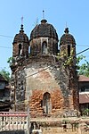
 Pancha ratna Radha Damodar temple of Das family
 -
 Terracotta relief in Radha Damodara temple
 -
 Pancha ratna temple of Dutta family built in 1790
 -
 Terracota relief in Dutta family temple
 -
 Bhuvneswar Shiva temple
 -
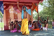 Gajan utsab at Shiva temple

.jpg)


References
edit- ^ "District Census Handbook: Hugli, Series-20, Part XIIA" (PDF). Physiography, Page 17-19. Directorate of Census Operations, West Bengal, 2011. Retrieved 25 September 2020.
- ^ "District Statistical Handbook 2014 Hooghly". Table 2.2, 2.4(a). Department of Planning and Statistics, Government of West Bengal. Retrieved 25 September 2020.
- ^ "2011 Census – Primary Census Abstract Data Tables". West Bengal – District-wise. Registrar General and Census Commissioner, India. Retrieved 22 September 2020.