Bulloo Downs is a rural locality in the Shire of Bulloo, Queensland, Australia.[2] It is on the Queensland border with New South Wales.[3] In the 2021 census, Bulloo Downs had "no people or a very low population".[1]
| Bulloo Downs Queensland | |||||||||||||||
|---|---|---|---|---|---|---|---|---|---|---|---|---|---|---|---|
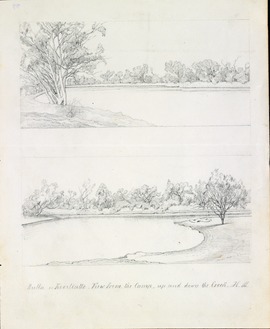 Sketch of Bulloo River area near the Kooliatto Waterhole, 1861 by Hermman Beckler, member of the Burke and Wills expedition | |||||||||||||||
 Bulloo Downs | |||||||||||||||
| Coordinates | 28°36′08″S 142°48′44″E / 28.6023°S 142.8123°E | ||||||||||||||
| Population | 0 (2021 census)[1] | ||||||||||||||
| • Density | 0.00000/km2 (0.00000/sq mi) | ||||||||||||||
| Postcode(s) | 4492 | ||||||||||||||
| Elevation | 93 m (305 ft) | ||||||||||||||
| Area | 11,252.1 km2 (4,344.5 sq mi) | ||||||||||||||
| Time zone | AEST (UTC+10:00) | ||||||||||||||
| Location |
| ||||||||||||||
| LGA(s) | Shire of Bulloo | ||||||||||||||
| State electorate(s) | Warrego | ||||||||||||||
| Federal division(s) | Maranoa | ||||||||||||||
| |||||||||||||||
On 17 April 2020 the Queensland Government reorganised the nine localities in the Shire, resulting in six localities. It included Bulloo Downs losing a portion of its western land to the locality of Cameron Corner while gaining a small portion from the south of the former Bullawarra (the rest being incorporated into Thargomindah).[4][5][6] The area of Bulloo Downs decreased from 12,814.6 square kilometres (4,947.7 sq mi) to 11,252.1 square kilometres (4,344.5 sq mi).[3]
Geography
editAdelaide Gate is a border crossing point on the Adelaide Gate Road/Track between Queensland and New South Wales (28°59′54″S 142°36′10″E / 28.9982°S 142.6029°E).[7]
History
editOne group of the Burke and Wills expedition camped in Bulloo Downs in 1861; three men from the group died and were buried there. This expedition provided information about the suitability of the land for pastoral purposes and the first recorded settlement was Bulloo Downs Station taken up by Jones, Sullivan and Molesworth Green in 1864.[8]
The locality takes its name from the Bulloo Downs Station. Bulloo is an Aboriginal word from the Kamilaroi language meaning slow.[2]
On 28 January 1919, the Queensland Government placed restrictions on the border crossing at Adelaide Gate to prevent the spread of the Spanish flu into Queensland, which were enforced by the Queensland Police. A medical screening process was used to determine if Queensland residents could safely return to the state.[9]
On 17 April 2020 the Queensland Government reorganised the nine localities in the Shire, resulting in six localities. It included Bulloo Downs losing a small portion of its western land to the locality of Cameron Corner while gaining a small portion from the south of the former Bullawarra (the rest being incorporated into Thargomindah).[4][5][6]
Demographics
editIn the 2016 census, Bulloo Downs had "no people or a very low population".[10]
In the 2021 census, Bulloo Downs had "no people or a very low population".[1]
Heritage listings
editBulloo Downs has a number of heritage-listed sites, including:
Education
editThere are no schools in Bulloo Downs nor nearby. The options are distance education or boarding school.[11]
References
edit- ^ a b c Australian Bureau of Statistics (28 June 2022). "Bulloo Downs (SAL)". 2021 Census QuickStats. Retrieved 28 February 2023.
- ^ a b "Bulloo Downs – locality in Shire of Bulloo (entry 42942)". Queensland Place Names. Queensland Government. Retrieved 6 September 2016.
- ^ a b "Queensland Globe". State of Queensland. Retrieved 28 December 2023.
- ^ a b "Job number 19-068: Bullawarra, Bulloo Downs, Cameron Corner, Dynevor, Noccundra, Nockatunga, Norley, Thargomindah". Recent place name decisions. Queensland Government. 17 April 2020. Archived from the original on 23 April 2020. Retrieved 28 June 2020.
- ^ a b "Proposed Locality names and boundaries for the Shire of Bulloo" (PDF) (Map). Queensland Government. 22 November 2019. Archived from the original (PDF) on 23 April 2020. Retrieved 28 June 2020.
- ^ a b "Locality names and boundaries for the Shire of Bulloo" (PDF) (Map). Queensland Government. 17 April 2020. Archived from the original (PDF) on 23 April 2020. Retrieved 28 June 2020.
- ^ "Adelaide Gate – locality unbounded in Shire of Bulloo (entry 116)". Queensland Place Names. Queensland Government. Retrieved 20 May 2024.
- ^ a b "Dr Ludwig Becker's Grave (entry 601359)". Queensland Heritage Register. Queensland Heritage Council. Retrieved 7 July 2013.
- ^ "FROM the VAULT - Queensland Border Policing During 1919 Influenza Outbreak". Queensland Police Museum. 9 June 2020. Retrieved 2 August 2024.
- ^ Australian Bureau of Statistics (27 June 2017). "Bulloo Downs (SSC)". 2016 Census QuickStats. Retrieved 20 October 2018.
- ^ "Layers: Locality; Schools and school catchments". Queensland Globe. Queensland Government. Retrieved 2 August 2024.
External links
edit![]() Media related to Bulloo Downs, Queensland at Wikimedia Commons
Media related to Bulloo Downs, Queensland at Wikimedia Commons