Biblins Bridge is a footbridge which crosses the River Wye between England and Wales, near Symonds Yat. The present structure dates from 1957, although there has been a crossing at this point since the early 20th century.
Biblins Bridge | |
|---|---|
 | |
| Coordinates | 51°49′35″N 2°39′19″W / 51.82644°N 2.6552°W |
| Carries | Pedestrians |
| Crosses | River Wye |
| Locale | Wye Valley |
| Begins | Monmouthshire |
| Ends | Herefordshire |
| Owner | Forestry Commission |
| Characteristics | |
| Material | Wood/steel |
| Total length | 57.9m |
| History | |
| Built | 1957 |
| Construction cost | £2,500 |
| Location | |
 | |
History and description
editA crossing at the point on the River Wye where Biblins Bridge now stands existed in the early 20th century and was used for the transportation of logs across the river.[a][b] In 1924, this crossing point was replaced with a footbridge.[3] In 1957 the Forestry Commission rebuilt the footbridge and this replacement is largely what stands today, although it has twice been the subject of major restoration, firstly in the 1990s, and again in 2020, after damage caused by Storm Desmond.[4][c] Land slippage due to flooding again impacted the bridge in 2021.[7]
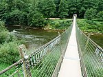
The bridge is constructed primarily of timber, with a steel walkway.[8] The walkway is strung between two wooden towers, and has a distinct sway.[9] The bridge is popular with walkers exploring the Wye Valley and the Forest of Dean.[10][11] There is a limit of six pedestrians using the bridge at any one time.[11] The bridge is the only crossing point for a 7-mile (11 km) stretch of the Wye, between Huntsham in Herefordshire 3 miles (4.8 km) to the north, and the Wye Bridge at Monmouth 4 miles (6.4 km) to the south.[3]
Gallery
edit-
 The bridge in 1958, a year after construction
 -
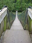 Approach to the bridge
 -
 View along the bridge
 -
 River Wye from the bridge


Notes
edit- ^ At the Biblins Bridge crossing point, the Welsh/English border runs down the middle of the River Wye. The bridge thus has one endpoint in Monmouthshire, Wales, and one in Herefordshire, England.
- ^ The English end of the bridge is the location for the Biblins Youth Camp, a camping facility operated by The Woodcraft Folk charity.[1] Biblins Lodge, a forester's cottage dating from the early 19th century, is recorded on the RCAHMW Coflein database.[2]
- ^ The wooden signpost erected in the 1950s, with distance markers to Monmouth and to Symond's Yat, was swept away in the flooding caused by Storm Desmond. It was recovered 40 miles (64 km) downstream at Portishead in Somerset, on the opposite side of the Bristol Channel.[5] It was later re-erected at the Biblins site.[6]
References
edit- ^ "Biblins Youth Camp". The Woodcraft Folk. Retrieved 31 January 2024.
- ^ "Biblins Lodge (410703)". Coflein. RCAHMW. Retrieved 4 February 2024.
- ^ a b "Biblins Bridge". Forestry England. Retrieved 31 January 2024.
- ^ Hughes, Janet (29 July 2020). "Gloucestershire's own Indiana Jones style bridge re-opens". Gloucestershire Live. Retrieved 31 January 2024.
- ^ Hughes, Janet (16 March 2020). "Workers move in to repair Biblins Bridge badly damaged by floods caused by Storm Dennis". Gloucestershire Live. Retrieved 31 January 2024.
- ^ Barnes, Dan (26 July 2020). "Campsite sign back after Storm Dennis took it to Portishead". Hereford Times. Retrieved 31 January 2024.
- ^ Thomas, James (24 May 2021). "Bridge over river Wye at risk of closure as water levels rise". Hereford Times. Retrieved 31 January 2024.
- ^ "Symonds Yat Rock Walks". Visit Dean Wye. Retrieved 31 January 2024.
- ^ Dunn 2013, p. ?.
- ^ "The Little Doward and Yat Rock". Ramblers Association. 2 December 2023. Retrieved 31 January 2024.
- ^ a b "The Doward - Biblins - Symonds Yat East - The Doward". walks.walkingworld.com. Retrieved 31 January 2024.
Sources
edit- Dunn, Mike (2013). Walking in the Forest of Dean: 25 Routes in the Historic Royal Forest. Kendal, Cumbria: Cicerone Press. ISBN 978-1-849-65899-7.