The Yantra (Bulgarian: Янтра ['jantrɐ]) is a river in northern Bulgaria, a right tributary of the Danube. It is 285 km (177 mi) long (the third longest Bulgarian tributary of the Danube, after Iskar and Osam), and has a watershed of 7,862 km2 (3,036 sq mi).[1] Its average discharge at the mouth is 47 m3/s (1,700 cu ft/s).[2]
| Yantra (Янтра) | |
|---|---|
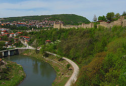
 The Yantra running through Veliko Tarnovo | |
| Location | |
| Country | Bulgaria |
| Physical characteristics | |
| Source | |
| • location | Central Stara Planina, Bulgaria |
| • elevation | 1,340 m (4,400 ft) |
| Mouth | |
• location | Danube, close to Svishtov |
• coordinates | 43°38′27″N 25°34′13″E / 43.6409°N 25.5702°E |
| Length | 285 km (177 mi)[1] |
| Basin size | 7,862 km2 (3,036 sq mi)[1] |
| Discharge | |
| • location | mouth |
| • average | 47 m3/s (1,700 cu ft/s) |
| Basin features | |
| Progression | Danube→ Black Sea |

The Yantra originates from the northern foot of Hadzhi Dimitar Peak in Central Stara Planina, at 1,340 m (4,400 ft). In its upper course, it is alternatively known as Etar (Етър), its older name. The river flows into the Danube close to Svishtov.
The river characteristically forms a number of gorges as it flows northward through the foothills of Stara Planina. The most prominent and longest one is 7 km (4 mi), located close to the capital of the Second Bulgarian Empire Veliko Tarnovo.
Major cities on the river are Gabrovo, Veliko Tarnovo, Gorna Oryahovitsa, Polski Trambesh, and Byala, close to which is the famous Belenski bridge.
Honour
editYantra Cove in Livingston Island in the South Shetland Islands, Antarctica is named after Yantra River.
References
edit- ^ a b c Statistical Yearbook 2017, National Statistical Institute (Bulgaria), p. 17
- ^ "Danube River Basin District, Part A - Roof Report" (PDF). ICPDR. April 2004. p. 12.