Wikipedia:WikiProject U.S. Roads/Assessment/A-Class review/Washington State Route 31
- The following discussion is an archived discussion of the proposal. Please do not modify it. Subsequent comments should be made in a new section on the talk page. No further edits should be made to this section.
The result of the proposal was Not promote due to stale nom. --Rschen7754 (T C) 01:04, 31 May 2009 (UTC)
Washington State Route 31
editWashington State Route 31 (edit | talk | history | links | watch | logs) review
- Suggestion: Promote to A-Class
- Nominator's comments: This article recently passed GA and I would like another A-class article for Washington.
- Nominated by: –CG 22:00, 9 May 2009 (UTC)
- First comment occurred: 00:47, 10 May 2009 (UTC)
Comments - I have some concerns with this article before I will support it for A-class:
- Change "which runs 26.79 miles (43.11 km)" to "which is 26.79 miles (43.11 km) long".
- In the sentence "Originally in 1964, SR 31 extended southeast to an intersection with U.S. Route 2 (US 2, formerly US 195) in Newport." add "created" after "originally".
- The last sentence of the second paragraph of the lead would look better at the beginning of the paragraph.
- Some of the sentences in the route description are rather long. Can they be split into shorter sentences so it reads better?
- Do not overuse "then" in the route description
- In sentence "After passing Lake Lucerene, SR 31 passes Crescent Lake and Boundary Lake before ending at the Canadian border." try not to use pass twice.
- "US 2, was signed over PSH 6 from Spokane to Newport in 1948": comma not needed after US 2.
- The last sentence in the PSH 6 (1937–1964) section looks long and should be split into two sentences.
- Again, avoid using "then" in describing a route.
- "the road goes north" sounds awkward.
- Again, try to find another verb instead of pass.
- An infobox for WA 311 is not nessecary in the article, an image of a WA 311 shield would simply suffice here.
- "State Route 311" should not be bolded as it does not redirect here.
- The sentence "The highway ran from US 2 west of Newport, north 15.24 miles (24.53 km) to SR 31 in Usk, a small community south of Cusick" sounds awkward.
- In next sentence, comma not needed after US 2
- Avoid using contractions such as "it's"
- In sentence "In October 2006, WSDOT finished a repaving project that repaved SR 31 from Metaline Falls to the Canadian border,[16] so that the roadway could handle heavy truck traffic", comma not needed after "Canadian border".
- The sentence "A photo of the road before construction shows cracks in the road as a truck drives by; now it's ready to handle heavy traffic" does not seem fitting in the article the way it sounds. It may need to be rephrased, preferably by using a better introduction than "A photo of the road before construction" and by avoiding contractions again.
- Change "started and concluded" to "was done".
- Can you describe the pedestrian improvements to the road?
- Are there any pictures of the road that can be added to the article?
- In the Major intersections table, how can boundaries to a national forest be considered a "major intersection"?
- "Continues as British Columbia Highway 6" should be in the notes in the "Canada – United States border" row. Dough4872 (talk) 00:47, 10 May 2009 (UTC)
I did everything you asked and here are my answers to your questions (19-20)
19. I can't because WSDOT only gave a description of "pedestrian improvments" on the projects list. There is no direct page. 20. No. I can't find any on Flickr or anywhere and I am not able to drive all the way there until Winter 2010 at the closest date. I live in Western WA and the highway is in the northeastern corner, nearly 350 miles away. –CG 17:15, 10 May 2009 (UTC)
- My issues have been addressed, so I will Support the article. However, it would be nice for some pictures to eventually be added to the article. Dough4872 (talk) 14:06, 11 May 2009 (UTC)
- Oppose - You are lacking vital information. Especially pre-designation.3 1/2 years of Mitch32 21:25, 11 May 2009 (UTC)
- Thanks Dough; I made a map of the route from 1964-1973 and added it to the article. Mitch, what specific areas I am lacking info in? There is no record of the road before 1923, when it became State Road 6. –CG 23:37, 11 May 2009 (UTC)
- Uh, In 531 and 31, you don't have any pre-designation history, meaning the roads before the highway was designated (turnpikes, plank roads, indian trails, early built highways, "Nomad trails", etc). Btw, the article is a joke in terms of being very good - I would personally GAR this.3 1/2 years of Mitch32 23:42, 11 May 2009 (UTC)
How many times do you use the word "becomes" in the route description? --Rschen7754 (T C) 01:46, 12 May 2009 (UTC)
- Oppose.
- The placement of the map image in the history section violates WP:MOSIMAGES, which prohibits left-aligned images to be placed immediately following a header.
- The caption for the SR 311 shield reads "The shield that identified SR 311". However, the caption should explain why the shield is there, as I'd imagine most readers can determine what it is.
- The entirety of the second paragraph of SR 31's history subsection seems to be comprised solely of minor incidents and improvements. Will these particular events matter 20 years from now?
There is an extraneous space before the link to BC 6 in the infobox. However, this appears to stem from the {{jct}} template.- Resolved by changing the value of Template:Infobox road/BC/shield Hwy. – TMF 21:25, 12 May 2009 (UTC)
- This is probably the item that first struck me when I saw the article and also caused me to comment and oppose. For an article that has been brought to ACR, it is woefully devoid of pictures, save for diagrams and shields. There are no historical maps (such as cropped old USGS topographic maps) or pictures of the actual road. If I had to review this article for GA, that would be a major sticking point for me and a major mark in my mind against the article. – TMF 03:14, 12 May 2009 (UTC)
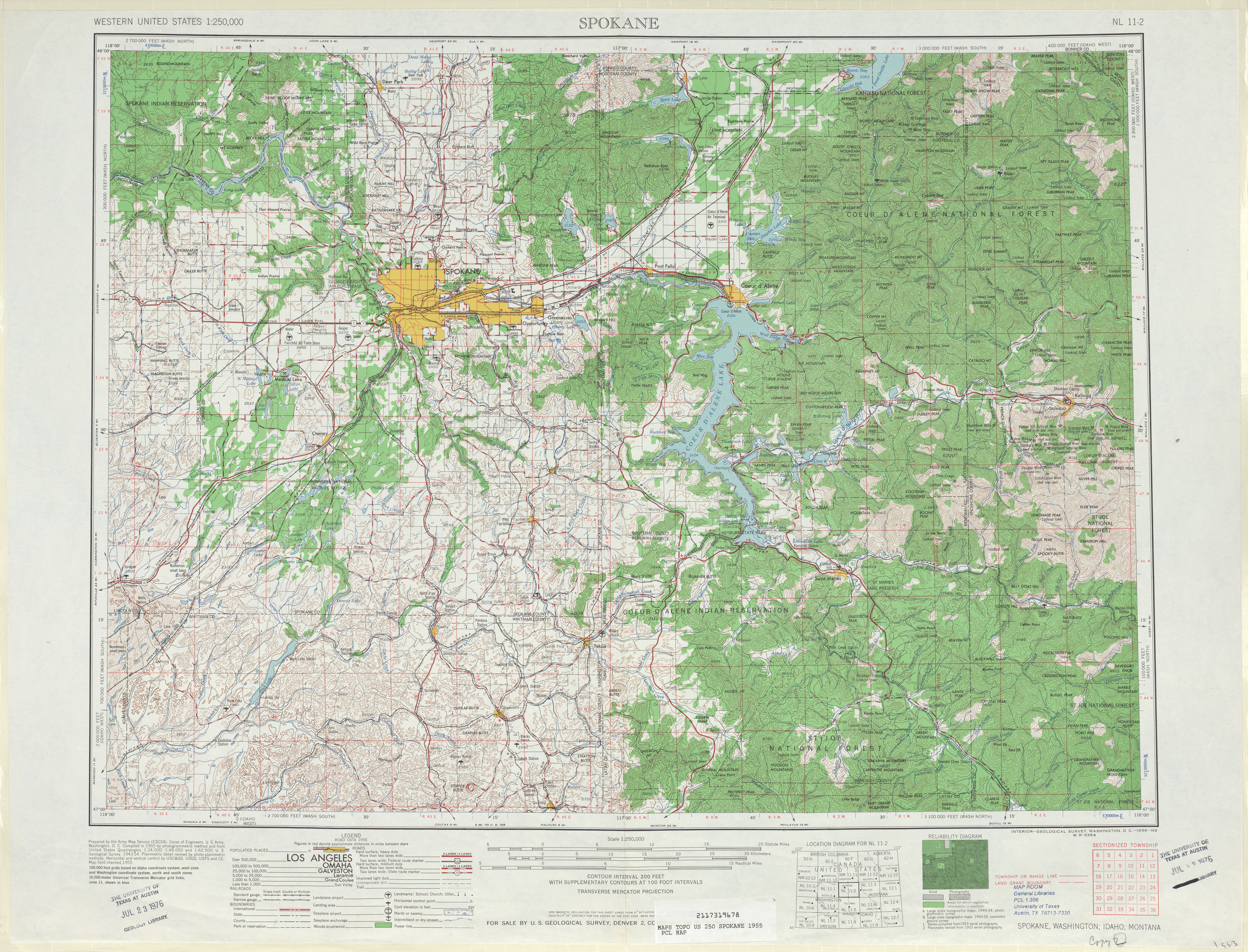
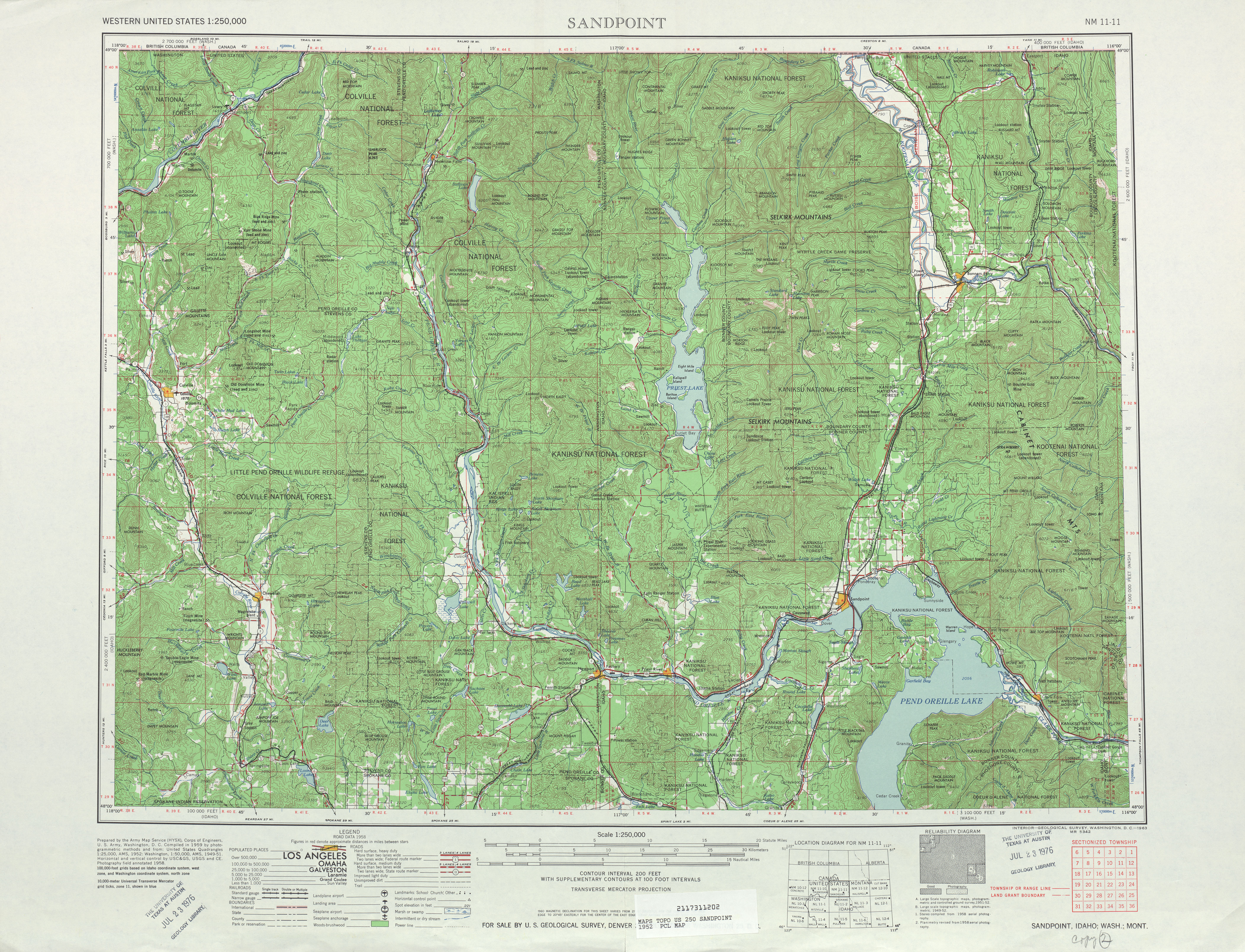
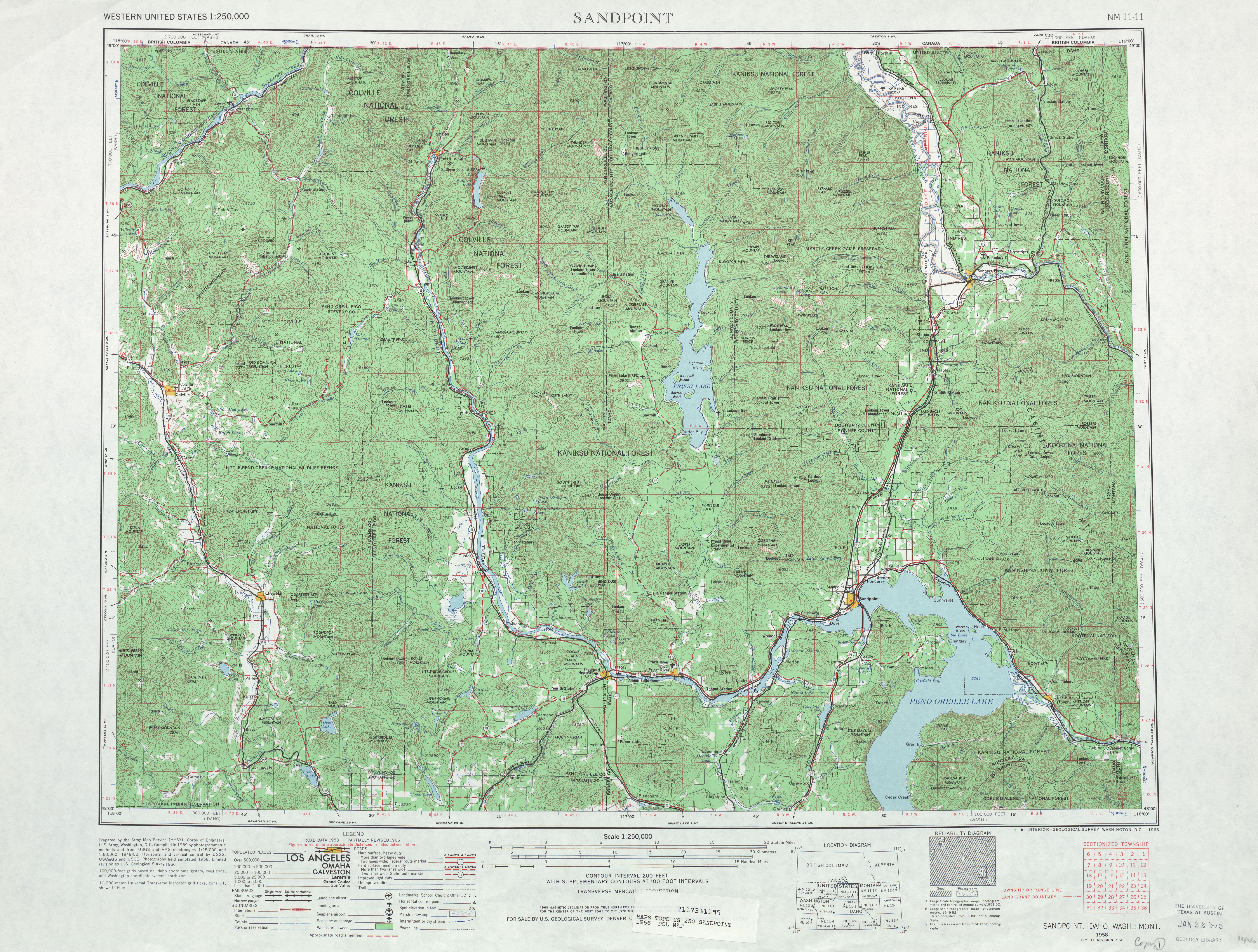
- Comment - I have found some USGS maps that could possibly be added as images to the article. Both this 1955 map of Spokane and this 1958 map of Sandpoint show PSH 6 while this 1966 map of Sandpoint shows WA 31 running south to Newport. Dough4872 (talk) 17:50, 12 May 2009 (UTC)
- Comment Are Washington state government works public domain? If so then I may have a source for route description pictures. --Rschen7754 (T C) 18:47, 12 May 2009 (UTC)
- Unless they've come right out and explicitly specified that their works are in the public domain, then they are most likely not PD. By default, works of state governments are not PD although some (I think I saw someone say Iowa was one) have explicitly declared their work to be PD. – TMF 21:03, 12 May 2009 (UTC)
- Responses to Comments:
- Mitch32: On 531 I put a map from 1911 that shows the early road that followed the current route. 31 has no history I can find yet...
- Rschen: Removed all instances in the Route description of, "becomes."
- TwinsMetsFans:
- Image realigned right.
- Probably not, but some (like the sinkhole) may be important.
- I could add a USGS map to replace the map in, "SR 31: Newport–BC 6 (1964–1973)."
- Dough: Thanks for the maps, I'll use one soon.
- Rschen (2): No. –CG 03:15, 15 May 2009 (UTC)
- Oppose. I echo many of the concerns above (image caption, random unencyclopedic stuff in the history, no RD pictures). Prose needs work.
- The highway parallels the Pend Oreille River for most of its route and connects Tiger, Ione, Metaline and Metaline Falls with British Columbia;[3] the route also parallels the Pend Oreille Valley Railroad from Tiger to Metaline Falls; the railroad extends south to Newport along SR 20 and east to Dover, Idaho.[4] - you can't combine two unrelated topics in one sentence.
- I find it hard to believe that it is called "Tiger E Road." Maybe Tiger East Road?
- parallel the shoreline of the Pend Oreille River and Pend Oreille Valley Railroad. - parallels both of them??
- The railroad crosses the road and later crosses the Pend Oreille River, as the highway turns northwest and reverts back northeast. - you use the same word twice!
- This is just a sample of the problems; please go through and clean up the prose. Reading this article makes me very uncomfortable. A-Class is not just GA-Class; it is a full review of an article before it goes to FAC. This article is nowhere near FA-Class or A-Class.
- Your heading structure for History just doesn't seem right. The organization seems to be off. That makes me uncomfortable as well.
- Either fix *all* of the above problems and do a thorough copyedit, or consider withdrawing this nomination. --Rschen7754 (T C) 07:16, 16 May 2009 (UTC)
If there is no attempt to resolve these issues by May 25 (Monday) then the article will be demoted. --Rschen7754 (T C) 22:42, 18 May 2009 (UTC)
I fixed all of your problems and will shortly get a copyediter on the job. –CG 15:21, 23 May 2009 (UTC)
- Uh, what about the random junk in the history section (which I had to remove myself)? What about pictures in the RD? Or the heading structure (which is still a mess?) -Rschen7754 (T C) 20:03, 23 May 2009 (UTC)
- If there is no attempt to resolve these issues by May 29 (Friday) then the article will be demoted. --Rschen7754 (T C) 03:27, 27 May 2009 (UTC)
- Demoted from what? –Juliancolton | Talk 16:11, 27 May 2009 (UTC)
- If there is no attempt to resolve these issues by May 29 (Friday) then the article will be demoted. --Rschen7754 (T C) 03:27, 27 May 2009 (UTC)
- The above discussion is preserved as an archive of the proposal. Please do not modify it. Subsequent comments should be made in a new section on this talk page. No further edits should be made to this section.