Absolutely all river articles should have a map, if using the Geobox template for the infobox there is already a space reserved for where the map should go - I suggest using it. I think the general map conventions are applicable to map of rivers as far as colors are concerned. As for what should go on the map is going to depend on the river and what data is available. I don't think consistency is as critical as showing the features important to the river being discussed.
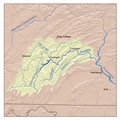
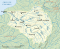
Drainage basins would ideally be on all of them, but for many rivers they simply aren't available, especially outside the U.S. Topography is nice, but can be tricky to get to look good and for rivers in non-mountainous areas might not be important.
Infoboxes and location map
edit
Mapping conventions
editUse of svg
editGallery of exemplars
edit- Gallery of Exemplars
-

-
-

-
-

-

-


Route diagrams
editFor shorter rivers, and navigations optionally can use the same route diagram that are used for canals
Route map conventions {{River Medway}} {{River Parrett map}}