Wikipedia:Graphics Lab/Map workshop/Archive/May 2013
Stale
editThis map in SVG
editThe image is map of Spain (1806). Would you become the image to SVG? Sorry if I don't write a good English, but I'm Spanish. Thank you. --Galdius (talk) 00:14, 2 March 2013 (UTC)
Exclusive Economic Zones
edit


Article(s): Exclusive Economic Zones
Request: delineate South Sudan... Kintetsubuffalo (talk) 01:00, 4 March 2013 (UTC)
Graphist opinion(s):
Map of Balankanche
editArticle(s): Balankanche
Request: Vectorization (image tracing) need a topographic map. In fact, by the decision of the Wikimedia is free (As a result of the court decisions, following parts of a map are in the public domain, and may be used freely: ... Geographic or topographic features. Those are facts, and facts aren't copyrightable), but to do all doubts vanished Vectorization (image tracing) better. Vyacheslav84 (talk) 06:17, 9 March 2013 (UTC)
Graphist opinion(s):
English translation of Spanish map of the Alhambra
edit
Request: English translation of Spanish map. Wereldburger758 (talk) 09:54, 20 February 2013 (UTC)
- What I would like are the translations of the towers and other important buildings in the Alhambra. Not the streetnames etc. Wereldburger758 (talk) 20:47, 10 March 2013 (UTC)
Graphist opinion(s):
A simple map
edit
Article(s): Uruguayan War
Request: Hi, I need a map like the one above, but far more simple (no towns or smaller rivers, for example) and with present-day national boundaries. Only with the name of the countries (and in English): Brazil, Argentina, Uruguay and Paraguay. Thank you very much, --Lecen (talk) 22:55, 10 March 2013 (UTC)
Graphist opinion(s):
Soviet and Eastern Bloc Location map
edit-
 A Soviet version of this map

Article(s): Kontinental Hockey League
Request: Expand this map to include the entire Warsaw Pact, or at lest Russia + Latvia + Belarus + Ukraine + Czech Repulic + Slovakia. Please show all country subdivisions (not only Russia) when possible. If relevant coordinates are provided so {{Location map USSR}} can be improved, that's even better. ibicdlcod (talk) 13:11, 23 March 2013 (UTC)
Suggestions needed
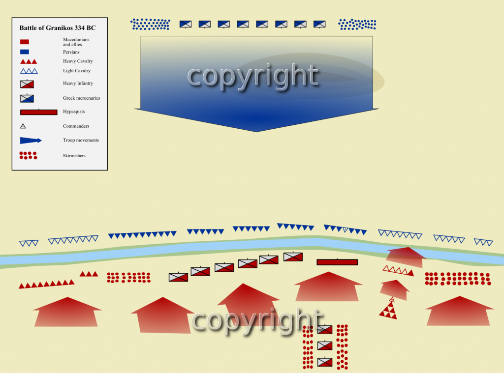
editArticle(s): Battle of the Granicus
Request: I have made a map (http://i938.photobucket.com/albums/ad223/flyingdutchman12/granikos1_d_a_zps688c7da1.png). Problem with it is, that it is an almost exact copy of a map out of the book "Warfare in the classical world". Only at the very end it dawned to me that publishing it on wikimedia commons could constitute a violation of copyright. I asked and I was right. Problem is: how do I change the map in such a way that it is all according to wikimedia-rules. Any suggestions? Wereldburger758 (talk) 07:28, 26 March 2013 (UTC)
Graphist opinion(s):
Resolved
editBalkans
edit-
 Original
 -

 Done:
Done:


Article(s): Demographic history of Macedonia, History of Kosovo and a couple more
Request:
- Could somebody improve this map by removing the tape marks visible on it? -- ArnoldPlaton (talk) 19:07, 18 April 2013 (UTC)
Graphist opinion(s):
- You might want to post this at the Photography Workshop instead, as it’s essentially a retouching job.—Odysseus1479 (talk) 21:11, 5 May 2013 (UTC)
Done --Lilot1338 (talk) 08:54, 6 May 2013 (UTC)
Range map for the White-faced Whistling Duck
edit-
 Blank world map (SVG)
 -


Article(s): White-faced Whistling Duck
Request: I would like to have a range map of the White-faced Whistling Duck (Dendrocygna viduata), but I suck at creating ranges on world maps that span across countries when using these blank world maps. The source for the range of the species can be found here on page 19 (16 of the PDF) on Map 7. A more up-to-date map can be found on the IUCN Red List (with spatial data). I will be working to completely revamp the article this map will go to over the coming weeks and hope to take it to FAC. Help with this map would be greatly appreciated. – Maky « talk » 22:30, 30 March 2013 (UTC)
Also, because I'm working on the Whistling duck article, it might be nice to create a conglomerate map of all their ranges. The same goes for range maps all all whistling duck species. There is so much good multimedia for these species that it might be worth creating a featured topic, and that would require range maps. This would be extra, though. I believe the same source will supply maps for all eight species, plus the IUCN Red List has maps for each as well. If anyone's up for it, please let me know. – Maky « talk » 00:38, 31 March 2013 (UTC)
Graphist opinion(s):
- My opinion: use a different map in order to create ranges. See gallery. A world map without borders. If you still want to use a map with borders, use layers. Wereldburger758 (talk) 14:23, 31 March 2013 (UTC)
- I'm fine with a borderless map. The borders are nice for people to see what countries the range overlaps, but it's not essential. – Maky « talk » 20:57, 31 March 2013 (UTC)

![]() Request taken by Fama Clamosa (talk) 09:47, 10 May 2013 (UTC).
Request taken by Fama Clamosa (talk) 09:47, 10 May 2013 (UTC).
- Done I gave this a quick go. The projection is very different in the PDF, so I had to do some guessing. Let me know if anything is wrong. --Fama Clamosa (talk) 09:47, 10 May 2013 (UTC)
Map scales
editCould someone please make up a few for commons? The ones there are not so hot. This style is perfect: [1] with the "Km" and "Mi" at end of the line, not whole words above and below. And with Km on top and Mi on the bottom. It's a nice style with the black and white -- very retro. Perhaps one showing 1km - 5km and another 10 to 50 or something -- maybe even a biggie 100 to 500. I'd be very grateful. Oh, and if you know where these are that we can steal, pls url me and I will upload them. Many thanks, Anna Frodesiak (talk) 22:44, 22 April 2013 (UTC)

Okay, I made that one, and it's awful. I have to stretch it to make it fit and then it's all fuzzy. I really don't understand how map people make these things. Svg? How can I add scales to OpenMaps is the big question. And please don't say exposrt openmaps as svg because a single map is like 300 MB and I don't know how to use those files anyhow. I'm trying hard and not doing well. Anna Frodesiak (talk) 04:13, 23 April 2013 (UTC)
- Yes, SVG is the recommended format, for accurate rendering at any size and for ease of editing. There are some sample scales in File:Maps_template-en.svg. But if those don’t work for you—they’re all for considerably smaller scales than your examples—it wouldn’t be much trouble to make something more like these.—Odysseus1479 (talk) 21:06, 5 May 2013 (UTC)
- File:Maps_template-en.svg looks good. If larger scale ones are needed then I'll come crying back here. Does Gimp do Svg? If not, do you know the easiest freeware program that can do a basic paste scale onto map task? Thanks, Anna Frodesiak (talk) 01:29, 9 May 2013 (UTC)
- For vector editing, you'll probably want Inkscape; it's free, powerful, and probably the most commonly used on Wikipedia. Dewclouds (talk) 02:35, 9 May 2013 (UTC)
Moose distribution
edit-
 This is the current map, which is wrong in many regards

Article(s): Moose
Request:
- See this talk page on Commons. The map currently used by many projects is riddled with fairly obvious errors. I wish I had thought about this a month ago as my free subscription to Highbeam Research just expired. If anyone can access highbeam or otherwise find the journal Alces I'm sure it would have more accurate data to use. (It's a journal entirely dedicated tot he scientific study of moose) If possible, it would be good to directly upload it to Commons as a replacement for the bad map that is currently used by many different projects. -- Beeblebrox (talk) 18:50, 10 May 2013 (UTC)
Graphist opinion(s):
- I fixed the worst of the problems, the sources I found were pretty marginal though, if you can find a better source I could probably make it better. Kmusser (talk) 16:50, 11 May 2013 (UTC)
Locator icon problem
edit
Can you tell me which group should get this request?
A problem with the locator map icons is that they are not WYSIWYG; when placed on maps they look different from what you see on the category pages. After testing a number of them separately I had to make a table similar to the attachment to make a correct selection. Something similar would make it easier for people to select map icons. Benjamin Trovato (talk) 03:47, 9 May 2013 (UTC)
- To extend this I put some random symbols on a map. Many do not show up well. Are these actually used? Is there a WP: page I have missed?Benjamin Trovato (talk) 06:06, 12 May 2013 (UTC)
- I think these would be useful. I'm not sure where the best place to put them is though. We do have our project page or location map conventions as possibilities - also the template page has examples and it could go there, for that matter it could go right in the commons category page - make an example section under the See Also. Kmusser (talk) 14:17, 12 May 2013 (UTC)
- I put it in Template:Location map many/doc. Someone can remove it if it's wrong. This section can be closed.Benjamin Trovato (talk) 07:00, 15 May 2013 (UTC)
- I think these would be useful. I'm not sure where the best place to put them is though. We do have our project page or location map conventions as possibilities - also the template page has examples and it could go there, for that matter it could go right in the commons category page - make an example section under the See Also. Kmusser (talk) 14:17, 12 May 2013 (UTC)
Syntax Error
edit


Request: Please pass this to whoever does the code for 'Location map many' and 'multiple image'. Thanks. Question: what causes the File:-etc error at top. I can't get it out. Benjamin Trovato (talk) 01:56, 18 May 2013 (UTC)
Graphist opinion(s): Templates have talk pages for exactly this sort of question, appealing directly to the authors of the template for any template problem should be the first place to go, in this case Template talk:multiple image and Template talk:location map many. Kmusser (talk) 02:39, 18 May 2013 (UTC)
- Moved. Thank youBenjamin Trovato (talk) 03:32, 18 May 2013 (UTC)