Wikipedia:Graphics Lab/Map workshop/Archive/Jun 2012
Stale
editDistricts of Ukraine in 1920s
edit-
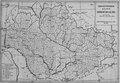 Map from book

Article(s): Okruhas of Ukraine
Request: Remove background, rivers, coordinate grid, make location maps for each okruha (district) and for raions in districts. Anatoliy (Talk) 10:08, 5 April 2012 (UTC)
Graphist opinion(s):
Korridorzuge or Treno corridoio
edit-
 Example image
 -
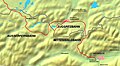 A second example


Article(s): de:Korridorzug and it:Treno-corridoio
Request: There is somebody who can draw a map as the image example, for the train rail which start from Innsbruck to Lienz, passing thrugh Italy? Llorenzi (talk) 11:33, 5 April 2012 (UTC)
Graphist opinion(s):
Levant
editArticle(s): [[1]]
Request:the Levant region has no proper map, the map is to include Syria, Jordan, Israel and Lebanon... Ramox5 (talk) 16:45, 10 April 2012 (UTC)
Graphist opinion(s): There are quite a few over in commons, are none of those good? Kmusser (talk) 14:16, 11 April 2012 (UTC)
Norway height c. 1265
edit
Article(s): I am currently working on Haakon IV of Norway where I'd like a more detailed map than the present one, but the map would be relevant for plenty other articles; History of Norway etc.
Request: I would like a better map of the Norwegian kingdom at its territorial height, c. 1265. For reference, I imagine something similar to the following map (from an external website) in a nice svg: [2] I can help with translations if necessary. Just for reference; other than the somewhat different border with Sweden from today (roughly includes what then belonged to Bohuslän, Värmland and Jämtland), outlying territories includes the Isle of Man, the Hebrides, Orkney, Shetland, the Faroe Islands, Iceland and Greenland (note that it only includes the settlements called the Western Settlement and the Eastern Settlement). —Filippusson (t.) 16:37, 11 April 2012 (UTC)
Graphist opinion:
Ottoman Vilayets
edit-
 Vilayets of Asia in 1909
 -
 Vilayets of Europe in 1910
 -
 Vilayets of Asia in 1911


Article(s): Vilayet. Derivative maps highlighting each vilayet would be created later.
Request: Creating an accurate location map of the inner borders of the late Ottoman Empire could prove something of a challenge, because there were countless modifications as a results of territories being annexed by other powers, as well as internal reforms. Sometimes, even maps published in the same year contradict one another on the extent of a province. The currently used location maps, such as this one for Sivas, are poorly made derivatives of a source file lacking factual accuracy (and yes, I created them :P). The three maps above, taken from western atlases from the early 20th century, are close enough in publication date (1909 to 1911) so that any risk of such discrepancies should be minimised. The location map should ideally show the Ottoman vilayets of Europe, Asia and Arabia (shown in the bottom left of the first map), either in the same file or separately, at the artist's discretion. eh bien mon prince (talk) 14:00, 14 April 2012 (UTC)
Graphist opinion(s):
Western World
edit
Article(s): Civilization, Samuel P. Huntington, Western world
Request: Can someone please correct the vandalism done by others which is based on original research. The description says that it is based after the Clash of Civilizations Map yet there are so many incorrect information on this map. Notable examples is how the Philippines is considered as a Latin American country when in the book, it is considered both a Western and Sinic country and how Mauritius and Seychelles are considered "Hindu" countries. I think this is a reliable source: Clash of Civilizations/Major Civilizations and so is this map here:

... Sairyu (talk) 21:16, 14 April 2012 (UTC)
Graphist opinion(s):
Map of Mithila
edit-
 India with states
 -
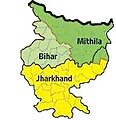 Mithila region of Bihar & Jharkhand
 -
 Mithila region in India


Article(s):
Request: Create a Map showing Maithili speaking region of India (i.e. The Proposed Mithila State) Vikas11004315 (talk) 13:39, 18 April 2012 (UTC)
Additional required information: The proposed state is presently spread along 30 districts in seven commissionaires of Bihar & Jharkhand states [1][2][3].
1) Muzaffarpur commissionaire (North West Bihar)
- East Champaran
- West Champaran
- Muzaffarpur District
- Vaishali District
- Sheohar District
- Sitamarhi District
2) Darbhanaga commissionaire(North Bihar)
3) Saharsa commissionaire (North Bihar)
4) Purnea commissionaire (North-East Bihar)
5) Munger commissionaire (South-East Bihar)
6) Bhagalpur commissionaire (South-East Bihar)
7) Santhal Parganas (North East Jharkhand)
Vikas11004315 (talk) 13:48, 18 April 2012 (UTC)
Graphist opinion(s):
Areas of Outstanding Natural Beauty
edit-
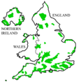 Map showing AONBs in UK

Article(s): Template:AONBs in England, Template:AONBs in Wales, Template:AONBs in Northern Ireland
Request: The map is out of date as the South Downs have been "promoted" to National Park status. If the whole map can be redrawn to a higher quality, so much the better. Ghmyrtle (talk) 18:00, 21 April 2012 (UTC)
Graphist opinion(s):
Kingdom of Georgia after Fragmentation
edit

Request:
- Please redraw first image into the format of SVG as it has in the second image by giving all kingdoms and principalities its borders but one green colour as it is in the second image.
- Please include only Kingdoms of Kartli, Kakheti and Imereti with Principalities of Guria (It's written Adscharien what is wrong as it is Guria), Svaneti, Abkhazeti, Samegrelo and Meskheti (Samzche should be written as Meskheti).
- Please include only these Georgian lands.
- Please do not include any more names but only the names of these 3 Georgian kingdoms and 5 principalities.
- Please do not include the neighboring states or lands.
Thank you. GeorgianJorjadze (talk) 19:12, 21 April 2012 (UTC)
- I am starting to believe that you are engaging in the creation of propaganda maps: not only are you "Georgifying" place-names and being very selective about what borders at wat time-periods you want to show, you are removing mention of adjacent territories which are necessary for a proper understanding of the time-periods depicted. Meowy 20:10, 21 April 2012 (UTC)
Graphist opinion(s):
Improve accessibility
edit-
 Map of economic growth and decline worldwide in 2009

Article(s): 2008–2009 Ukrainian financial crisis, 2008–2012 global financial crisis, and Contemporary history
Request: My red-green colorblindness makes this map almost meaningless to me — I can't tell the difference between 10%+ growth rates and 10%+ shrinkage rates. All I'm asking is that you change some colors away from green-based to something such as blue-based, but I don't care whether you change the growth or the shrinkage. Nyttend (talk) 12:04, 14 April 2012 (UTC)
Graphist opinion(s):
- The trouble with color-blindness is that there is always one group excluded. A solution is to use not color gradiants, but darkness gradiants. By the way, Nyttend: we need color blind graphists to push forward this issue, make test, and proposal such as a color palette. Yug (talk) 15:10, 19 April 2012 (UTC)
- So...because you can't make everyone happy all at once, you refuse to do anything at all? Please read color blindness; while the blue idea isn't the best, you could pick something that's friendly both to red/green and blue/yellow people. Nyttend (talk) 12:35, 26 April 2012 (UTC)
French Republic map
edit-
 Map of France, including overseas departments and territories

Article(s): France
Request: Please vectorise and rename File:French Republic.svg. Also, if possible, can the big blue block in the pacific (French Polynesia) be turned into individual blue dots (a map is here) -- Peter Talk page 20:16, 29 April 2012 (UTC)
Graphist opinion(s):
Resolved
editNCAA bids by state (women's basketball) for one year
edit-
 Men's version
 -
 my stab at this


Article(s): 2011 NCAA Men's Division I Basketball Tournament, 2011 NCAA Women's Division I Basketball Tournament
Request:
- I think I figured this out myself, but before I go ahead and 30 maps, I've love it if someone looked at my image, and passed along any suggestions for improvement, in particular, how do I add Washington, D.C., as I seem to be unable to select it in Inkscape.--SPhilbrick(Talk) 17:02, 28 May 2012 (UTC)
- I found another map with DC. --SPhilbrick(Talk) 15:26, 4 June 2012 (UTC)
 Resolved
Graphist opinion(s):
Mixture map - World and India (Very Urgent)
edit-
 Blank World map
 -
Blank India map

Article(s): Ra.One
Request: Okay, this is a complicated request, so I'll be detailed to avoid any future problems. I want to have something of a film-print distribution map. In the World map, I want the following :-
- Coloring of countries
- Light yellow - Germany, South Korea, US, UK, China
- Light green - Taiwan, New Zealand, Russia, the entire Middle East, Australia, Canada
- Orange - Pakistan, Singapore, Lebanon, Jordan, Syria and Palestine , Brazil , Spain, Italy, Greece
- Light blue - India
- Within the shaded regions, I want certain numbers to be written as well. The necessary numbers are :- Germany (600), South Korea (250), US (344), UK (202), China (1,000), Taiwan and New Zealand (25 each), Russia (75), Middle East (79), Australia (51), Canada (49), India (3,500). Please add an asterisk to China. For the countries not mentioned, nothing should be written in the respective shaded regions.
Now here comes the tricky bit. I want India to be circled in the World map and zoomed up in such a way that the zoomed portion comes out of the World map; the zoomed map will be the blank India map. In this India map :-
- All states except Tamil Nadu and Andhra Pradesh must be shaded light pink. In this shading, 3,100 should be written.
- Tamil Nadu should be shaded light brown. In this shading, 275 should be written.
- Andhra Pradesh should be shaded light grey. In this shading, 125 should be written.
A key should also be added. It should go as such, in this order :-
- Orange - N/A
- Light green - <100 prints
- Light yellow - 100 to 1,000 prints
I know this could be a bit of a challenge in terms of time, but I need this map quite urgently for FAC purposes. I'd be really obliged if somebody could do this map by today or at least by tomorrow. Thanks! ~*~AnkitBhatt~*~ 16:45, 11 May 2012 (UTC)
Graphist opinion(s):
![]() Done I applied the legend colors to the Indian states map (I think it makes more sense.) I also didn't use zooming here to avoid cluttering and covering parts of the map. I hope you like the result. Cheers! -- Orionist ★ talk 21:59, 30 May 2012 (UTC)
Done I applied the legend colors to the Indian states map (I think it makes more sense.) I also didn't use zooming here to avoid cluttering and covering parts of the map. I hope you like the result. Cheers! -- Orionist ★ talk 21:59, 30 May 2012 (UTC)
- P.S. you might want to check the image description and the Commons categories (I have no idea what category applies here.)

Can you please create a map for this following page?
edit
Article(s): Visa requirements for Uzbekistani citizens
Request: Can you please create a map for this page similar to (http://en.wikipedia.org/wiki/Visa_policy_of_Ukraine) map? This page ( Visa requirements for Uzbekistani citizens ) needs map. Thanks... B (talk) 13:26, 20 May 2012 (UTC)
Graphist opinion(s):
![]() Done This proved not as straightforward as it should be, so please check for any errors. Regards, -- Orionist ★ talk 10:37, 25 May 2012 (UTC)
Done This proved not as straightforward as it should be, so please check for any errors. Regards, -- Orionist ★ talk 10:37, 25 May 2012 (UTC)
Map fixing
edit-
 Image of U.S. states with coastlines.

![[2]](http://cdn.dipity.com/uploads/events/ffc2ca0ca5ba957c0a9548d8c36137cd_1M.png)
.svg)
.svg)
Article(s): Coastal states
Request: This is a map that shows what U.S. states have coastlines. Green states are states with Great Lakes shorelines and red states are states with an ocean coastline or both Great Lakes and ocean coastlines. The states of Maryland should be shaded red because it has a coastline on the Atlantic Ocean but it is shaded gray. Shadow (talk) 23:30, 27 May 2012 (UTC)