Wikipedia:Graphics Lab/Map workshop/Archive/Jun 2009
Stale
editPDF conversion
editArticle(s): Nizhny Novgorod and several other articles, including those in the Russian segment of Wikipedia.
Request: Recently, Russian Graphic Lab has received a request that none of our specialists can handle. Nizhny Novgorod's city administration posted online several schemes (supposedly in public domain), that give some very useful information on the city's development plan, transportation, zoning and general borders. Russian user made a request to extract the layers from PDF file and place them into SVG, AI or CDR files. After several attempts, it turned out that members' computers didn't have sufficient resources to proceed the request and all of the attempts have failed. Though, we were able to identify that the files were all created in AutoCAD and then converted to PDF. Now, if there is any chance to do this, could someone here at the English Graphic Lab help us and complete the request? Thanks in advance. --Ahnode (talk) 12:39, 29 March 2009 (UTC)
- Summary scheme of the functional planning organization of the city's territory 17 mb
- Functional zoning scheme 17 mb
- Scheme drawing of areas and sites of historical and cultural heritage 38 mb
- Road development scheme 8 mb
Graphist opinion: I tried, they crash both Inkscape and Illustrator on my machine. Kmusser (talk) 17:31, 9 April 2009 (UTC)
- Thank you for the attempt Kmusser =). I withdraw the request, since we've tried so many times and obviously there is something wrong with the files. --Ahnode (talk) 01:40, 10 April 2009 (UTC)
Markakol lake map
edit-
 Markakol lake map (File:Markakol map-ru.svg)

Article(s): Markakol
Request: This map can be opened with Firefox and Inkscape, but it can't be seen as thumbnail. Could you resolve this problem? There is also some letter spacing issues: mountain range names looks good in Inkscape, but not in firefox. Thank you --Mikhail2009 (talk) 10:37, 22 March 2009 (UTC)
Graphist opinion: First problem solved, spacing issue remains --Ahnode (talk) 10:46, 5 April 2009 (UTC)
- What do you means by "spacing" issue ? Yug (talk) 13:00, 14 April 2009 (UTC)
- Please compare PNG (rendered with Inkscape) and SVG version. Just below big lake in center, there is a mountain range - хребет Азутау. Letter spacing is different in PNG (as in Inkscape) and SVG (in Firefox there is not letter spacing, also this text is not rendered in preview in commons). Thank you --Mikhail2009 (talk) 20:24, 16 April 2009 (UTC)
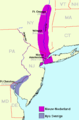
Canada Provinces 1970-1871
edit
Article(s): Manitoba Act
Request: SVGify.. Connormah (talk) 22:46, 14 April 2009 (UTC)
Graphist opinion:
Comment: This map is part of a series, the rest of them can be seen at Territorial evolution of Canada.Kmusser (talk) 01:16, 15 April 2009 (UTC)
- Ah, that's fine. Disregard the request. Connormah (talk) 23:51, 16 April 2009 (UTC)
Olympic map
edit-
 SVG Map of Rio de Janeiro's location

Article(s): Rio de Janeiro bid for the 2016 Summer Olympics and Infrastructure of the Rio de Janeiro bid for the 2016 Summer Olympics
Request: Upload the map displayed in Rio de Janeiro Candidate File under the name "File:Rio de Janeiro bid map for the 2016 Summer Olympics.svg".
Sources:
- The 3rd page of the Rio de Janeiro Candidate File (Vol. 1)
- The 11th page of the Rio de Janeiro Candidate File (Vol. 3)
Felipe ( talk ) 20:01, 7 April 2009 (UTC)
Graphist opinion:
Before we can upload an SVG, what is the copyright status of this? --RaviC (talk) 09:00, 9 April 2009 (UTC)
- All rights are reserved to the Brazilian Olympic Committee (BOC), but as a map, and provided that a copy is not explicit, it can be uploaded under a free license, as it possesses elements that are under public domain. Felipe ( talk ) 14:04, 9 April 2009 (UTC)
- Somebody could do this, please? Felipe ( talk ) 18:11, 27 April 2009 (UTC)
- Sorry, it's a difficult request, doing a straight copy would be a copyright violation; doing a re-creation would be a lot of work as those aren't simple maps and we don't have a decent public domain city map of Rio to use as a basemap. Kmusser (talk) 18:36, 27 April 2009 (UTC)
- Somebody could do this, please? Felipe ( talk ) 18:11, 27 April 2009 (UTC)
Pitcairn Islands
edit-
 Henderson Island Map.jpg
 -
 Oeno Atoll Island Map.jpg


Article(s): Pitcairn Islands, Henderson Island, Oeno Island
Request: Create SVG versions AnonyLog (talk) 15:28, 24 April 2009 (UTC)
Graphist opinion:
- The best would be to ask the author at EVS-Islands if he accepts to release the vector versions, or at least PNGs. Sting-fr (talk) 12:10, 29 April 2009 (UTC)
Resolved
editA dot for Macau
edit-
 Map.
Map.

Article(s): Pacific War
Request: Please add a green dot next to Hong Kong for Macau and upload over the original. Thanks. SelfQ (talk) 23:43, 30 May 2009 (UTC)
Graphist opinion: Done. Kmusser (talk) 02:34, 31 May 2009 (UTC)
- Where? Can't see it? When was it taken over? Ucla90024 (talk) 02:50, 31 May 2009 (UTC)
- You may need to refresh your cache if it's not showing up, but Macau is located next to Hong Kong and was taken in 1887. Kmusser (talk) 05:04, 31 May 2009 (UTC)
- Looks good, Thanks.--SelfQ (talk) 15:52, 1 June 2009 (UTC)
- You may need to refresh your cache if it's not showing up, but Macau is located next to Hong Kong and was taken in 1887. Kmusser (talk) 05:04, 31 May 2009 (UTC)
IPhone availability (easy!)
edit-
 Existing map needs 3 countries changed

Article(s): iPhone
Request: Just a quick heads-up that the map needs updating. Bulgaria can now be coloured, and Malaysia and Indonesia need to be changed green-->blue, per [1]. I would do it myself, but unfortunately I only know how to do PNGs not SVGs. Thanks, Bernerd (talk) 01:43, 5 June 2009 (UTC), on Talk:iPhone. Posted here by HereToHelp (talk to me) 02:45, 5 June 2009 (UTC)
Graphist opinion(s): ![]() Done Kmusser (talk) 12:58, 8 June 2009 (UTC)
Done Kmusser (talk) 12:58, 8 June 2009 (UTC)
Map needs updating (Biometric passport)
edit-
 Map of countries with biometric passports

Article(s): Biometric passport
Request: The map needs to be updated. Sudan should be turned to the green color please, and thank you very much for your effort in putting together the map
Graphist opinion(s): ![]() Done Kmusser (talk) 13:09, 8 June 2009 (UTC)
Done Kmusser (talk) 13:09, 8 June 2009 (UTC)

Article(s): Australian Magpie
Request: I have two maps (photos of reference book maps not available online), which detail the range of eight subspecies which overlap a little across the Australian continent and southern New Guinea. As they are thus Fair Use, I was unsure about posting them and suspected emailing them to whomever takes the request may be more prudent. I also have page refs and full details of books for proper attribution. Casliber (talk · contribs) 13:16, 28 May 2009 (UTC)
Graphist opinion: Email me the photos and I'll make a map as soon as possible. ChrisDHDR 18:07, 28 May 2009 (UTC)
- I've made the map but it's not showing on MediaWiki. I'm not sure if it's the cache again or something more annoying. If it doesn't show itself in a day or two I'll have to find help. ChrisDHDR 12:30, 9 June 2009 (UTC)
- It looks terrific. I will revisit - why would it not appear/ weird....Casliber (talk · contribs) 12:40, 9 June 2009 (UTC)
 Done now I see, thanks and very much appreciated! Casliber (talk · contribs) 22:01, 13 June 2009 (UTC)
- It looks terrific. I will revisit - why would it not appear/ weird....Casliber (talk · contribs) 12:40, 9 June 2009 (UTC)
Krakatau Map
edit

Article(s): Krakatau
Request: Please make a SVG out of this. Thanks. 96.52.53.138 (talk) 22:28, 28 April 2009 (UTC)
Graphist opinion: I'll try to do one in the next couple of days. ChrisDHDR 18:28, 4 May 2009 (UTC)
- I have made the map but there are some MediaWiki problems. Anyone know how to help fix them? ChrisDHDR 14:37, 11 May 2009 (UTC)
- ? I don't see any Mediawiki problem with this map. Bourrichon (talk) 13:35, 10 June 2009 (UTC)
H1N1 map
edit-
 H1N1 map

Article(s): 2009 flu pandemic
Request: Mark the Isle of Man red please.--SelfQ (talk) 14:44, 16 June 2009 (UTC)
Graphist opinion(s): Isle of Man isn't visible on a world scale map, there isn't even a dot on there to mark it. Kmusser (talk) 01:54, 17 June 2009 (UTC)
- It is if you zoom in. But someone has already added the isle of man. So never mind.--SelfQ (talk) 09:47, 17 June 2009 (UTC)
SVG map for Antarctica
edit-
 SVG map of Europe
 -
 PNG map of Antarctica
.svg)

Article(s): Antarctica
Request: Following discussion at Antarctica's talk page, and at WikiProject Geography, could an SVG map be made for Antarctica, based on the existing SVG map used by Europe? Could blue be used instead of green, however, to indicate the Antarctica is a polar region? This flag once was redpropagandadeeds 11:38, 19 June 2009 (UTC)
Graphist opinion(s):
- I have since created the following SVG map. Bosonic dressing (talk) 02:20, 22 June 2009 (UTC)

- Many thanks! One small request, though... would it be possible to centre it on the South Pole? Makes no difference to me, but I suspect people will be confused if it isn't centred... Cheers, This flag once was redpropagandadeeds 16:45, 22 June 2009 (UTC)
- NP. Actually, the near polar aspect was intentional (i.e., not centred on the South Pole, but at 80 S), intended to convey the continent's southerly nature (with north being 'up'); I planned to do the reverse for the Arctic. As well, the map caption elaborates. I could move the aspect closer to the pole (centred on 85 S), but I think one would lose the sense of north/south if the map was centred on the pole. Thoughts? Bosonic dressing (talk) 17:28, 22 June 2009 (UTC)
- Aha! That makes sense. No further issues from me! Cheers, This flag once was redpropagandadeeds 17:38, 22 June 2009 (UTC)
- NP. Actually, the near polar aspect was intentional (i.e., not centred on the South Pole, but at 80 S), intended to convey the continent's southerly nature (with north being 'up'); I planned to do the reverse for the Arctic. As well, the map caption elaborates. I could move the aspect closer to the pole (centred on 85 S), but I think one would lose the sense of north/south if the map was centred on the pole. Thoughts? Bosonic dressing (talk) 17:28, 22 June 2009 (UTC)
- Many thanks! One small request, though... would it be possible to centre it on the South Pole? Makes no difference to me, but I suspect people will be confused if it isn't centred... Cheers, This flag once was redpropagandadeeds 16:45, 22 June 2009 (UTC)
Orthographic map of Africa
edit.svg)
Can an orthographic map be made of Africa (with countries)? It may be useful as a template for other countries. Connormah (talk) 13:57, 24 June 2009 (UTC)
- Here you go.--23230 talk 11:38, 25 June 2009 (UTC)
- Thanks! --Connormah (talk) 14:14, 25 June 2009 (UTC)
- Killing two birds with one stone... I've pinched your map for SVG maps for continents (above) ;-) Cheers, This flag once was redpropagandadeeds 14:42, 25 June 2009 (UTC)
File:Nieuw Nederland and Nya Sverige.png
edit-
 Map of New Netherland

Article(s): Several
Request: It should be CT, not CO for Connecticut. MBisanz talk 01:29, 26 June 2009 (UTC)
Graphist opinion(s):
![]() Done Bogomolov.PL (talk) 05:04, 26 June 2009 (UTC)
Done Bogomolov.PL (talk) 05:04, 26 June 2009 (UTC)
SVG maps for continents
edit-
SVG map of Europe
-
 SVG map of Africa
 -
 SVG map of the Americas
 -
 SVG map of Asia
 -
 SVG map of North America
 -
 SVG map of Oceania
.svg)
.svg)

.svg)
Article(s): Africa, Americas, Asia, North America, Oceania
Request: Following discussion at the relevant articles' talk pages, and at WikiProject Geography, could SVG maps be made for the above articles, based on the existing SVG map used by Europe? Europe's map style has many "country" variants already, e.g. India, Canada, Australia, Brazil - so I'm hoping this should be a fairly straightforward task? This flag once was redpropagandadeeds 11:38, 19 June 2009 (UTC)
- Note: a map for South America was already done, hence its omission here. Bosonic dressing (talk) 15:41, 20 June 2009 (UTC)
Graphist opinion(s): I am working on the final one for the Americas. One question, the Europe map does not show the country borders, is that intentional? To keep them consistent, it would be easy to delete them from the other maps, but harder to add them to the European one without the original file.--23230 talk 16:28, 25 June 2009 (UTC)
- Good work, and good question. It would make sense to include the borders in the map for Europe I was gonna recreate the map for Europe through the Online Map Creator utility, and 'integrate' (i.e., copy and scale) the borders over into it. But, the other maps are (IMO) priorities. Bosonic dressing (talk) 19:15, 25 June 2009 (UTC)
- Perhaps we could make a second one with the boundaries, as a separate file, for a template for possible ortghographic projections of European countries. Just my thought, though. Connormah (talk) 23:46, 25 June 2009 (UTC)
![]() Done: There is the last one. As for the borders I kept them on, it is presumably up to WikiProject Geography to decide whether they want them or not. I will mark this as resolved.--23230 talk 16:26, 26 June 2009 (UTC)
Done: There is the last one. As for the borders I kept them on, it is presumably up to WikiProject Geography to decide whether they want them or not. I will mark this as resolved.--23230 talk 16:26, 26 June 2009 (UTC)
- Fantastic! A big "thank you" to both graphists. The new maps look fantastic. Cheers, This flag once was redpropagandadeeds 17:42, 26 June 2009 (UTC)
Italians in Somaliland
edit-
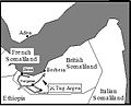 Map of the Italian invasion of British Somaliland
 -
 A wonderful map of Somaliland that might be of use for placenames or even as a background


.svg)
Article(s): Italian conquest of British Somaliland
Request: The current B/W map (see above) is of very poor quality, and a replacement might be nice. Classical geographer (talk) 15:18, 14 April 2009 (UTC)
Graphist opinion:
![]()
 Classical geographer (talk) 22:24, 8 July 2009 (UTC)