Wikipedia:Graphics Lab/Map workshop/Archive/Jul 2013
Stale edit
A minor change to a map edit
At the article Age of consent, some minor changes to this map [1] if possible:
- Central African Republic: must be 18 on the map (Ages_of_consent_in_Africa#Central_African_Republic)
- Peru: must be 14 on the map (Ages_of_consent_in_South_America#Peru).
- also: the color for age 12 must be changed (a light yellow I think would do); and the color for age 13 must be a little lighter (a lighter shade of blue) because the map currently uses 5 shades of blue (for ages 12, 13, 14, 15, 16) which are quite difficult to distinguish from one another on the map.2A02:2F0A:505F:FFFF:0:0:50C:DD93 (talk) 17:38, 11 May 2013 (UTC)
Formula 1 circuit maps edit
For a while now, I've been bothered by the way the style of the diagrams for Formula 1 circuits have been wildly inconsistent, and would like to make a uniform set of diagrams for use in articles about the sport, such as race articles. Since I'm not very good with graphics programs - I can barely draw a stick figure in MS Paint - and I've been having a bit of trouble getting people from the Formula 1 WikiProject involved, I thought I'd ask for some help here.
I've put all the details on a sub-page of my sandbox, which you can find here: User:Prisonermonkeys/sandbox/circuitproject. Any and all help that you can provide would be greatly appreciated. Prisonermonkeys (talk) 04:23, 14 May 2013 (UTC)
Freopedia location map edit
-
 A suitable model: Location map United Kingdom London City of London

Article(s): Articles forming part of Freopedia (for use in their infoboxes)
Request:
- For the purposes of Freopedia (which was officially launched today, and covers Fremantle, Western Australia), we need a suitable location map that can be used in the infoboxes of the articles forming part of the Freopedia project. Something similar in concept to Location map United Kingdom London City of London is what is required, but covering the City of Fremantle (official website here, and click here to access its online mapping system) instead of the City of London. -- Bahnfrend (talk) 13:29, 26 May 2013 (UTC)
Graphist opinion(s):
Larak Island edit
-
A map of Larak Island, Iran.
-
A map of the entirety of Iran with Larak Island's location highlighted.
Article(s): Larak Island
Request:
- Pretty simple. For the 1st one, just the shape of the island with roadways or towns running through it, if any. For the 2nd one, take a map of all of Iran and any of the surrounding region that can fit in the image and in comparison, on the same map, mark he location of Larak Island with whatever you see fit (box, light colored circle, etc.) Thank you! -- 1Matt20 21:49, 28 May 2013 (UTC)
Graphist opinion(s):
Resolved edit

The author of this image: File:Pennines edited-1.jpg has recently retired, leaving no details as to how the boundary was created. I wonder if anyone would be able to create a replacement, based explictly on WP:RS sources? Is this a possible start point? Thanks. Martinevans123 (talk) 13:41, 18 May 2013 (UTC)
- Just a nudge from another editor here. This is still an outstanding request, and still needed - or should the request go somewhere else? If any more guidance is needed, a word from a graphics expert to the article talk page should sort it out. Thanks. Ghmyrtle (talk) 14:27, 11 June 2013 (UTC)

. Or perhaps contour map of the UK, like this section, might be another good starting point? Martinevans123 (talk) 09:23, 15 June 2013 (UTC)
- Looks like we're now going with this one: File:Pennines location map.png. Martinevans123 (talk) 10:58, 16 June 2013 (UTC)
 Done Hellerick (talk) 13:02, 16 June 2013 (UTC)
- Thanks for your help. Martinevans123 (talk) 13:08, 16 June 2013 (UTC)
South Sudan CAF membership edit

Article(s): 2014 FIFA World Cup qualification, 2018 and 2022 FIFA World Cup bids, FIFA and Football continental championships
Request:
- South Sudan joined the CAF on 10 February 2012, so please colour it like the other CAF members to reflect that.
Graphist opinion(s):
LGBT rights in the world edit
-
 Current map

Article(s): Major map. Widely used in various Wikipedia projects, including Wikipedia's in pretty much every language.
Request:
- 0) Also made this request at Commons [2]
- 1) Make the map more in line with a reliable source: [3]
- 2) Add '"Propaganda law” restricting freedom of expression and association' (i.e., colour Russia)
- 3) Keep legal column colours as they are.
4) Change illeagal column colors: remove colour green (colour blind people confuse this colour [4]); merge "Up to life in prison" and "Heavy penalty"; and come up with a new colour scheme. The suggested scheme for illegal column:
:Cavann (talk) 00:23, 27 May 2013 (UTC) Withdrawn; editing svg maps was much easier than I thought Cavann (talk) 01:36, 4 July 2013 (UTC)
Graphist opinion(s):
African Union map -- URGENT and easy please edit
Article(s): African Union, Template:Politics of the African Union
Request:
- Egypt has just been suspended from the body after the 2013 Egyptian coup d'état and the map needs to reflect that by changing the colour of the country to light green. Thanks Lihaas (talk) 12:49, 5 July 2013 (UTC)
Graphist opinion(s): Done. Kmusser (talk) 15:58, 5 July 2013 (UTC)
Amelia Earhart flight route edit
-
 Start with something like this, then add lines for her route?
 -
 Or it might be better to start with a map centered where she went missing?


Article(s): Amelia Earhart
Request:
- I would like to make a map of Amelia Earhart's flight plan to circumnavigate the world in 1937. I have it in table form in my sandbox, and was hoping there was an interactive map template where the points or lines could be created with latitude/longitude coordinates. Does such a template exist, or will I simply have to "eyeball" my lines on a world map? Hoof Hearted (talk) 12:42, 21 June 2013 (UTC)
Graphist opinion(s):
- Is this map okay?
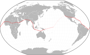
- Hellerick (talk) 16:10, 6 July 2013 (UTC)
- Wonderful! Much thanks! Hoof Hearted (talk) 19:04, 8 July 2013 (UTC)

![]() Done: when the request is done.
Done: when the request is done.
- It needs a legend for what the different line types mean. I'm guessing solids = traveled, dashed = thought traveled, small dash = planned but not traveled? I don't want to add it in case I'm wrong. gren グレン 02:19, 9 July 2013 (UTC)
- Yes, that may be an improvement and your guesses are correct. I added a table with Hellerick's picture to the Amelia Earhart article which I believe helps tie everything together as is. But if you'd like to add a legend, feel free. Hoof Hearted (talk) 15:10, 9 July 2013 (UTC)
- It needs a legend for what the different line types mean. I'm guessing solids = traveled, dashed = thought traveled, small dash = planned but not traveled? I don't want to add it in case I'm wrong. gren グレン 02:19, 9 July 2013 (UTC)
State color edit

Article(s): List of Presidents of the United States by home state
Request:
Graphist opinion(s):
- The map is currently matching the 2nd table (which associates Hoover with California rather than Iowa), to make it match the 1st table we'd also need to change California as well. I'd get the two tables to agree first before we go changing the map, I don't know which one is correct. Kmusser (talk) 14:02, 11 July 2013 (UTC)
- Ah, ok, helps if I read! United States presidential election, 1928 also lists California, not Iowa, so I withdraw this request. Thanks, CTF83! 23:21, 11 July 2013 (UTC)
Suriname and the Commonwealth edit
.png)
Article(s): Commonwealth of Nations membership criteria
Request:
- Colour Suriname in green to indicate its eligibility to join the Commonwealth, as it was an English colony from 1650 and 1667 (as Willoughbyland) and later a British colony from 1799 to 1816. [1].
Graphist opinion(s): Done. Kmusser (talk) 17:43, 5 July 2013 (UTC)
Burundi and the Commonwealth edit

Article(s): Commonwealth of Nations membership criteria
Request:
- Burundi has expressed interest in joining the Commonwealth [2], though it was never part of the British Empire, so please colour it in orange. Another thing the border between Sudan and South Sudan is missing from this map, so please fix that.
Graphist opinion(s): Done. Kmusser (talk) 17:44, 5 July 2013 (UTC)
2012 Presidential Elections Map edit
-
 Countries holding presidential elections during 2012

Article(s):
- Various articles on various Wikipedia's.
Request:
- The file 2012 Presidential Elections Map.svg need to add the South Sudan please. -- WikiAnthony (talk) 02:11, 14 June 2013 (UTC)
Graphist opinion(s): Done. Kmusser (talk) 17:05, 5 July 2013 (UTC)
1930 & 1934 World Cups - British India edit


![[1]](https://en.wikipedia.org/wiki/File:Age_of_Consent_-_Global.svg)
Article(s): All the articles these maps are already on.
Request:
- Burma was a part of British India until 1937, and yet these maps show it to be separate from India for the first two FIFA World Cups in 1930 and 1934. Would someone please remove the border between Burma and India on both of these maps.
Graphist opinion(s): Done. Kmusser (talk) 16:55, 5 July 2013 (UTC)
Commonwealth of Nations - Nepal and Bhutan edit
Article(s): Commonwealth of Nations membership criteria
Request:
- Nepal was a British protectorate until 1923 and Bhutan was a protectorate of British India until 1947, so would someone please colour them in green on both these maps to show their eligibility to join the Commonwealth.
Graphist opinion(s): Done. Kmusser (talk) 00:41, 10 July 2013 (UTC)
Commonwealth - Suriname eligible and interested status edit
Article(s): Commonwealth of Nations membership criteria
Request:
- Colour Suriname in green and orange like Sudan, Yemen etc., as it was a former British colony (from 1799 to 1816) that has expressed interest in joining the Commonwealth (see http://www.allvoices.com/contributed-news/12377129-suriname-plans-to-join-the-commonwealth)
Graphist opinion(s): Done. Kmusser (talk) 02:04, 22 July 2013 (UTC)