Wikipedia:Graphics Lab/Map workshop/Archive/Feb 2012
Stale edit
Map of the German Reich edit
-
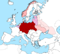 German Reich during World War II
 -
 Blank map

.svg)
Article(s): Nazi Germany
Request: Could someone draw an SVG map of the German Reich, during WWII using the blank map as a base, please many thanks. TRAJAN 117 (talk) 06:49, 6 December 2011 (UTC)
Graphist opinion(s):
Brazil map request (?) edit
Article(s): Brazil
Request: Do something with them... 38.100.109.4 (talk) 21:28, 9 December 2011 (UTC)
NormanEinstein, could you please use your "Fertile_Crescent_blank_base_map" to make a modern-day middle east outline showing current countries, to match the fertile crescent map you've previously published? Thanks!
38.100.109.4 (talk) 21:28, 9 December 2011 (UTC)
Graphist opinion(s):
Maui Bus Route Map edit
-
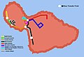 Maui Bus Transit Map

Article(s): Maui Bus
Request: I did this poor transit route map for Maui Bus. The differences between the one produced by the county and the one by me was that I tried to at least follow the actual route on some of them literally (namely the Lahaina Villager (where I almost followed it's route in a general sense....for lack of better words) and Lahaina Islander routes (took a much different angle versus the original), and took a different liberty with two routes (Wailuku Loop and Kahului Route) versus the County map (Oriented both routes to be in the general areas, so to speak vs. the poor geographical side-by-side of the county map). I'm just wondering if the map could be improved upon to make it look more professional. I'm thinking, from an aeriel POV, the routes are color coded and follow it's routes near exactly. or if the map is inferior and another method would be much more feasible? 293.xx.xxx.xx (talk) 02:43, 17 December 2011 (UTC)
Graphist opinion(s):
A whole bunch of old maps (srs, a ton) edit


Article(s): Category:User-created_public_domain_images_from_August_2004
Request: Don't hate me, but there are 133 elections data images similar to the three examples above in this category. They're all .png, and I think they should probably be .svg...but I don't have the skill to re-draw them as .svgs. Can any of you? (Alternatively, if I'm an idiot and they really would be better staying as .png files, feel free to tell me so openly, and in those exact words if it amuses you). ♠PMC♠ (talk) 08:00, 23 December 2011 (UTC)
Graphist opinion(s):
Resolved edit
Administrative divisions of Myanmar edit
-
 Base map
 -
 Example of a highlighted state
 -
 Example of a highlighted region


Article(s): Administrative divisions of Myanmar
Request: Create a new image, File:Administrative regions of Myanmar.svg or the equivalent, based on File:Myanmar location map.svg. All of the first-level administrative divisions should be shaded in with a color to indicate whether it is a "Region" or a "State". A guide to which is which is in the names of the files in commons:Category:SVG locator maps of administrative divisions in Myanmar (location map scheme). Shrigley (talk) 19:35, 14 January 2012 (UTC)
Graphist opinion(s):
![]() Done: File:Myanmar states location.svg Shrigley (talk) 15:37, 5 February 2012 (UTC)
Done: File:Myanmar states location.svg Shrigley (talk) 15:37, 5 February 2012 (UTC)
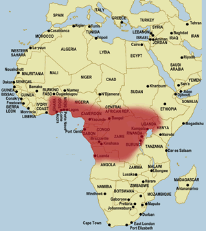
Jameson's mamba Distribution map edit
-
 A map to use to make the map of the Jameson's mamba's distribution
 -


Article(s): Jameson's mamba
Request: The Jameson's mamba article needs a map of its geographical distribution in Africa. The species is mostly found in Central Africa (you can go here to see a map of it's distribution in Africa). However, I'd like you to go a bit further north into Sudan (stop just a little north of South Sudan). Also, I would like you to include the far eastern part of Zambia, so just spread Angola's eastern spread a little further east into Zambia, please. Basically, the species can be found all the way from northern Angola eastwards towards Zambia, north to the Democratic Republic of Congo, Republic of Congo, Uganda, Rwanda, Kenya, Burundi, South Sudan, Sudan, Central African Republic, Cameroon, Gabon, Ghana, Togo, Nigeria, and Equatorial Guinea. — Preceding unsigned comment added by Sebastian80 (talk • contribs)
Graphist opinion(s):
![]() Request taken by Orionist.
Request taken by Orionist.
![]() Done -- Orionist ★ talk 16:06, 10 February 2012 (UTC)
Done -- Orionist ★ talk 16:06, 10 February 2012 (UTC)
Map translation: Battle of Bautzen (1945) edit
-
 Map 1
Map 1 -
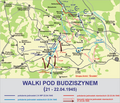 Map 2
Map 2 -
 Map 3
Map 3


Article(s): Battle of Bautzen (1945)
Request: Milhist A-class reviewers suggested getting those maps translated. I hope it will be doable; ping me for translation when somebody is willing to work on that. PS. The request is less scary than the maps appear; placenames are fine, only milunit names and legend would need switchover. Piotr Konieczny aka Prokonsul Piotrus| talk to me 23:38, 3 January 2012 (UTC)
Graphist opinion(s): Since these are PNG files it might be a good idea to try and contact the creator of these images, who seems to be an active user on Commons and wp:pl. If the creator won't do the request for any reason, let me know and I'll pick up the request. Cheers! -- Orionist ★ talk 15:04, 9 January 2012 (UTC)
- The creator is no longer very active, and I am afraid it may be health issues. If you could try to help, it would be appreciated! --Piotr Konieczny aka Prokonsul Piotrus| talk to me 16:25, 15 January 2012 (UTC)
- Alright then. I just need the translation from you so I could start working on them. Cheers! -- Orionist ★ talk 19:56, 17 January 2012 (UTC)
- Sorry, it took a while. Note when the sentence was mostly repeating the previous ones, I just changed the repeated part (usually, nationality). Let me know if sth is not clear. --Piotr Konieczny aka Prokonsul Piotrus| talk to me 22:31, 24 January 2012 (UTC)
-
- Legend:
- Operacja Berlinska - Berlin Operation
- Etap -> Phase
- polozenie wojsk polskich -> position of Polish forces
- ... niemieckich -> German
- ... radzieckich -> Soviet
- kierunki natarcia wojsk polskich -> Polish forces offensive direction
- ...Soviet...
- Map
- Front Bialoruski -> Belorussian Front
- Front Ukrainski -> Ukrainian Front
- 1A, 2A -> 1st Army, 2nd Army
- add English name to two rivers (add, not replace, if possible): 1) Odra -> Oder, 2) Nysa Luzycka ->Lusatian Neisse
- Legend:
- Walki pod Budziszynem: Battle of Bautzen (Budziszyn)
- poloxrnie jednostek 2 A WP po... -> location of 2nd Polish Army units after [date]
- sowieckich... -> Soviet units...
- niemieckich... -> German units...
- kierunki natarcia jednostek n. -> German units offensive direction
- Map
- river: change szprewa to Spree
- military abbreviations:
- pp -> infantry regiment, so Inf Reg
- DP -> Inf Div
- AWP -> Polish Army
- AGw -> guard army, so Gd Army
- DSGw -> Guard Rifle Div,so Gd Rif Div
- DPGw -> Guard Inf Div,so Gd Inf Div
- KPancGw -> Guard Armored Corps, Gd Armd Corps
- Grupa Armi Srodek - Army Group Centre
- DPanc -> Pz Div
- Same changes as above, I see only one new abberv: BPanc -> Armored Brigade, so Armd Brg
I'm on it (sorry for the delay!) -- Orionist ★ talk 07:42, 31 January 2012 (UTC)
- A couple of issues before I upload the files:
- Two things were missing from translation: A --> I translated as Army, KPanc --> I translated as Armd Corps. Are they correct?
- I changed "Berlin Operation" to "Battle of Berlin", which I think is more accurate.
- To be in correct chronological order, shouldn't the "a" and "b" in the file names of the Bautzen maps be the other way round?
- Cheers! -- Orionist ★ talk 06:54, 2 February 2012 (UTC)
- Yes, yes, and it would seem so - weird, how about we use dates in the title instead of a/b for full clarification? --Piotr Konieczny aka Prokonsul Piotrus| talk to me 17:24, 5 February 2012 (UTC)
-
 Map 1
Map 1 -
 Map 2
Map 2 -
 Map 3
Map 3


![]() Done. I kept the a-b designation (in correct order) to help people note that this is a 2-part map. I also noticed that the Battle of Berlin map has a second part: File:Operacja berlin 2 1945.png, so, in super-market style I'll give you a buy-three-get-one-free offer and do an English version of that last map if you provide the translation. Cheers! -- Orionist ★ talk 18:15, 10 February 2012 (UTC)
Done. I kept the a-b designation (in correct order) to help people note that this is a 2-part map. I also noticed that the Battle of Berlin map has a second part: File:Operacja berlin 2 1945.png, so, in super-market style I'll give you a buy-three-get-one-free offer and do an English version of that last map if you provide the translation. Cheers! -- Orionist ★ talk 18:15, 10 February 2012 (UTC)
- Sure, I am glad to help. New phrases:
- Legend:
- Niemieckie wysilki... -> German attempts to relieve Berlin (April - May 1945)
- kierunki odwrotu -> retreat direction
- Niemieckie wysilki... -> German attempts to relieve Berlin (April - May 1945)
- Zgrupowanie Pancerne... -> Panzer Group of the Army Group Centre of gen. Schorner
- Grupa Armijna... -> Army Group of gen. Steiner
- Legend:
I hope I didn't miss anything. And as long as we are making Berlin maps, would you be interested in this relatively simple map of German defenses? [1] ? --Piotr Konieczny aka Prokonsul Piotrus| talk to me 20:28, 10 February 2012 (UTC)
-
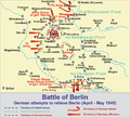 2nd Berlin map

![]() Done Here's the last map. I'll respond to your new request on your talk page, so we can close this request as resolved. Cheers! -- Orionist ★ talk 04:09, 14 February 2012 (UTC)
Done Here's the last map. I'll respond to your new request on your talk page, so we can close this request as resolved. Cheers! -- Orionist ★ talk 04:09, 14 February 2012 (UTC)
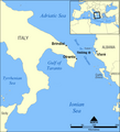
Tragedy of Otranto edit
-
 Possible base map

Article(s): Tragedy of Otranto
Request: I was hoping someone could use the map above to label Vlorë, Otranto, Brindisi, and Sazan all of which are mentioned in the article. The map in this link (page 7) could be useful and I think it shows the area where the ship sank. Maybe that should be included as well.Gaius Claudius Nero (talk) 17:57, 28 January 2012 (UTC)
Graphist opinion: {Keithpickering (talk) 04:01, 14 February 2012 (UTC)}
-
 With toponyms and sinking site.

![]() Done
Done
- Thanks a lot.--Gaius Claudius Nero (talk) 18:23, 19 February 2012 (UTC)
Request for voter ID requirements map edit
-
 Blank map
 -
New SVG map
.svg)
Article(s): Voter ID laws (United States)
Request: Can someone create a map identical to the one at the top of this page, along with its color-coding legend? Thanks! Duoduoduo (talk) 15:48, 2 February 2012 (UTC)
Formatted the individual's request. Evan.oltmanns (talk) 03:37, 3 February 2012 (UTC)
Graphist opinion(s):![]() Request taken by Makeemlighter.
Request taken by Makeemlighter.
![]() Done I can change the colors or add a legend if desired. Makeemlighter (talk) 02:19, 11 February 2012 (UTC)
Done I can change the colors or add a legend if desired. Makeemlighter (talk) 02:19, 11 February 2012 (UTC)
Mongol Empire map edit
-
 Extent of the Mongol Empire as of 1259.

![[1]](http://imageshack.us/f/688/img0003fqb.jpg/)
Article(s): Mongol Empire, Kublai Khan, Golden Horde, others
Request: Please clean this up. It dosen't have to be an SVG if that's not convienant, but I'd like for it to be a higher quality than it is. Sven Manguard Wha? 16:48, 24 November 2011 (UTC)
P.S. Yes, I know it's on Commons, and no, I don't want to make the request there, I'd prefer someone here handle it.
Graphist opinion(s): {Keithpickering (talk)}: Given the very large longitude span of the empire, I'm thinking a cylindrical projection would be better than orthographic. Most of the interesting detail is at the edges, and that gets pretty badly distorted with orthographics. Also I'd like to draw the empire and non-empire areas in different shades of gray, with pink (instead of the awful red) for the tributary states.
-
First try
How does this look? Keithpickering (talk) 23:14, 13 February 2012 (UTC)
- This is a major improvement. If it's not too difficult, could we remove the five labels (Persia, Russia, etc.) please? Sven Manguard Wha? 23:24, 13 February 2012 (UTC)
No problem. Keithpickering (talk) 01:55, 14 February 2012 (UTC)
![]() Done
Done
- Thanks! Sven Manguard Wha? 02:57, 14 February 2012 (UTC)