Wikipedia:Graphics Lab/Map workshop/Archive/Apr 2010
Stale edit
Jaguar Distribution edit
-
 Current Map
 -
 Existing SVG


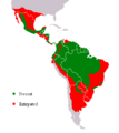
Article(s): Jaguar
Request: Please update the SVG map, and change the colors to match the gif. Connormah (talk) 05:02, 7 December 2009 (UTC)
Graphist opinion(s): I see that the gif map is used in most Wikipedias and the svg map is used only on the French version. My concern is that neither map is referenced. Maybe the French map is (more) correct. Is there any reference that anyone could provide which could validate either map? MapMaster (talk) 21:41, 30 January 2010 (UTC)
- The SVG gives the gif as its source on its description page, so it looks like it was a poorly done SVGification attempt. Kmusser (talk) 22:17, 30 January 2010 (UTC)
Fuerteventura edit
Article(s): Fuerteventura
Request: Is it possible for someone to create a locator map of the island? There is currently no map in existence other than one showing Municipal boundaries. TheBigJagielka (talk) 00:17, 14 January 2010 (UTC)
Graphist opinion(s): What kind of map do you want? Do you want it to show the municipalities or not? --Shandristhe azylean 15:23, 11 February 2010 (UTC)
SUCRE (currency) edit

Article(s): SUCRE (currency)
Request: Create File:Map of participants in the Bolivarian Alliance for the Americas.svg, in English, wikified colors and closer trim. I know there's an orthographic one out there. Please make this a wiki-one, grey land, white ocean... Chris (クリス • フィッチュ) (talk) 17:44, 9 February 2010 (UTC)
Graphist opinion(s):
.svg)
- The SVG at right already exists. I think the projection used here looks much nicer, though adding labels would be good. Calliopejen1 (talk) 12:51, 11 February 2010 (UTC)
Europe Map Images edit
.png)
Article(s): Copenhagen criteria, Borders of the continents
Request: For neutrality, we must include all states appearing on the list of states with limited recognition. Outback the koala (talk) 06:24, 19 February 2010 (UTC)
Graphist opinion(s):
Article(s):
Request: Can someone link to (or create) a map of countries of Europe as for a child? Just as books for children first starting to read have very little text, which itself is as simple as possible ("the dog is small, the cat is big") can someone link to a simplified map of Europe, as for a child, which simple has each country in a different solid color and not text or features other than the names of the countries, NOT abbreviated. I've seen many maps that fit my requirements, except for this last point: ALL the ones I could find assume you already know the country and so that it is fair to abbreviate it, or maybe just put a number correspondig to/a line connecting It directly with a legend. I feel this unnecessarily complicates things, makes it hard to learn the name of the countries. Is there a map somewhere (or could you create one) which is large enough for each country actually to contain it's own name in readable type? Some near misses:
[1] (closest to what I have in mind; problems with this one: not all countries colored, several abbreviated).
[2] (not all countries labelled; I don't like that some adjacent countries have the same color)
there are several other near misses, and them some real ugly ones where the names go way outside the border of the smaller countries, it is hard to tell which country is which. I would really like each name WELL inside its borders, even if that means the whole map has to be relatively big or the font relatively smaller (shouldn't be tiny though...)... Thank you for anything like that you might know of or be able to create for me :). Best wishes... 89.204.153.66 (talk) 17:33, 20 February 2010 (UTC)
Graphist opinion(s):
- I am posting this at Wikipedia:Graphic Lab/Map workshop for you. --Chris (クリス • フィッチュ) (talk) 17:42, 20 February 2010 (UTC)
Tikal site map edit
-
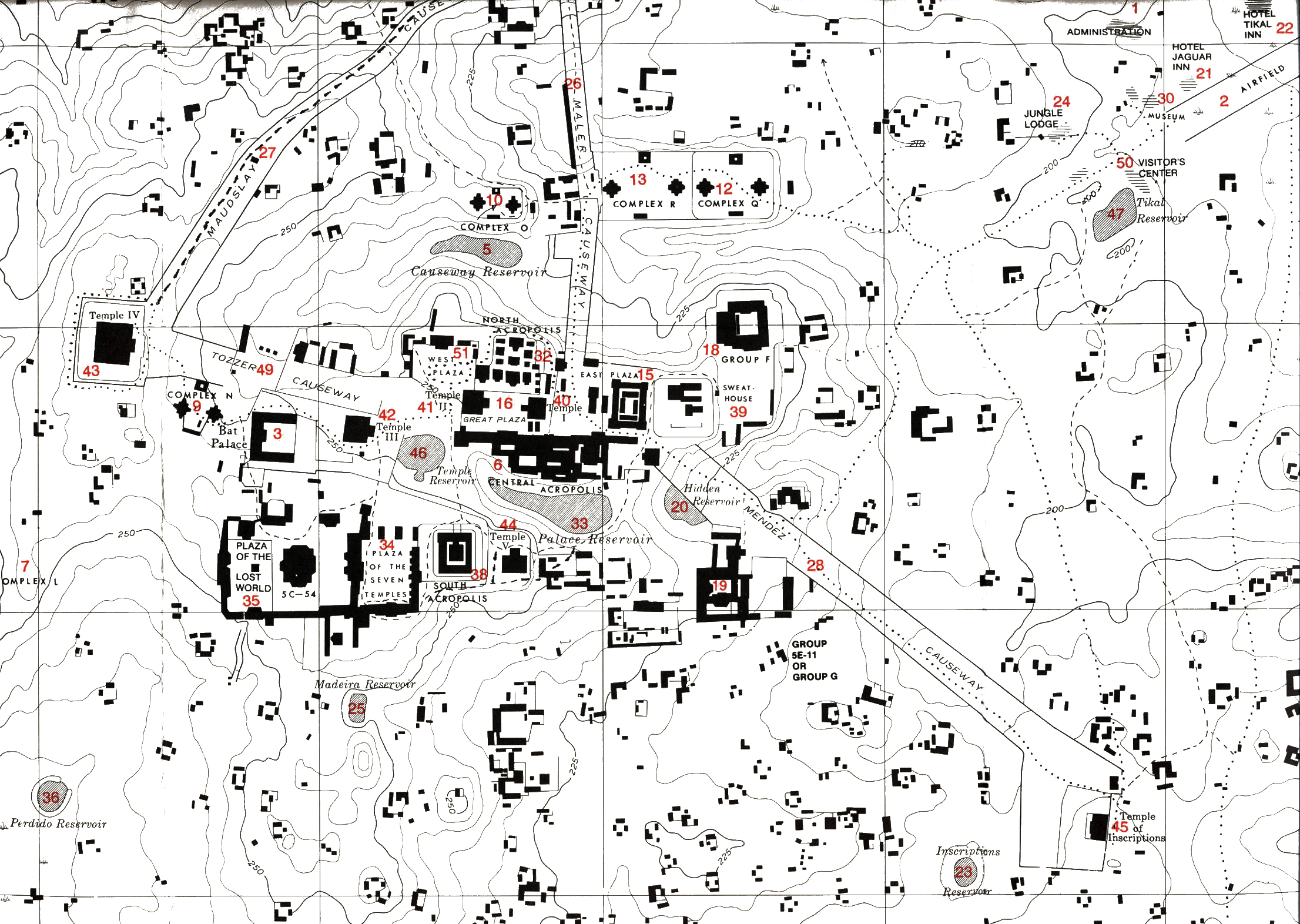
 Map of the archaeological site of Tikal

Article(s): Tikal
Request: Tikal was relatively recently passed as GA, during the process the reviewer asked for a site map and the effort I produced, while functional, is pretty poor and lets down an otherwise nice article on an important and well known archaeological site. Any help producing a better map would be much appreciated. Many thanks, Simon Burchell (talk) 19:46, 22 February 2010 (UTC)
References: An online version of part of the paper map I used is here. The paper version was taken from the following, which is a Spanish translation of an English-language book, I believe the English title is Tikal, a handbook of the ancient Maya ruins, with a guide map.
- Coe, William R. (1988). Tikal: Guía de las Antiguas Ruinas Mayas (2 ed.). Guatemala: Piedra Santa. ISBN 84-8377-246-9. (in Spanish)
Another online version, showing the northern part of the site core, is here.
Graphist opinion(s):
![]() Request taken by Chaosdruid.
Request taken by Chaosdruid.
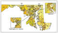
State Highway Network Map for Kerala State edit
-
 Roads in Kerala Map
 -
 Indian National Highway Network Map


Article(s): Articles in Category:State Highways in Kerala
Request: We WP:INR has used derivatives of Indian National Highway Network Map to the articles in Category:Indian National Highways. We would like to create a map for State Highway Network Map for Kerala State. We can give you full support with the information. There are about 76 State Highways in Kerala -- naveenpf (talk) 02:11, 26 February 2010 (UTC)
Graphist opinion(s):
Maryland General Assembly edit
-
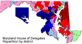 House of Delegates (with current representation)
 -
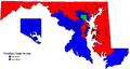 Senate (with current representation)
 -
 Hybrid


Article(s): Maryland House of Delegates, Maryland Senate, Maryland General Assembly
Request: The first two images are incredibly hard to read. The third generic one which shows both Senate and House of Delegates is easier to read but could be vectorized / improved. It'd be great to have them all made into the same exact style with the only differences being the coloring. I think vectorization would make future changes much easier if anyone is up for the task. gren グレン 04:08, 26 February 2010 (UTC)
Graphist opinion(s):
Resolved edit
Kurdish-inhabited area edit
.jpg)
Article(s): multiple
Request: since there is not an inset, can we remove the "area of block diagram"? Chris (クリス • フィッチュ) (talk) 05:43, 3 April 2010 (UTC)
Graphist opinion(s):![]() Done Calliopejen1 (talk) 17:09, 3 April 2010 (UTC)
Done Calliopejen1 (talk) 17:09, 3 April 2010 (UTC)
Ionian Islands edit

Article(s): Ionian Islands
Request: Please remove the derisive term FYROM, it's unnecessary and it violates NPOV as it denigrates an accepted UN member... other countries are unlabeled Chris (クリス • フィッチュ) (talk) 16:19, 3 April 2010 (UTC)
Graphist opinion(s): Done. Kmusser (talk) 14:39, 4 April 2010 (UTC)
- Thank you! --Chris (クリス • フィッチュ) (talk) 15:38, 4 April 2010 (UTC)
Map splicing edit
-
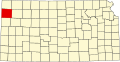 Kansas
 -
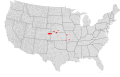
 Colorado
 -
 Nebraska


-
 Nebraska
 -
 Kansas


-
 Missouri
 -
 Kansas


-
 Missouri
 -


-
 TastyCakes' first attempt.

Round 2!
-
 Kansas, Missouri
 -
 Kansas, Nebraska
 -
 Kansas, Colorado, Nebraska


Article(s): The up-and-coming National Weather Service Goodland, Kansas, National Weather Service Hastings, Nebraska, National Weather Service Pleasant Hill, Missouri and National Weather Service Springfield, Missouri
Request: Could someone please splice the maps in each particular gallery with the other one(s) in that gallery? Sorry it's a large request, and it can be treated as multiple requests if desired. Also, please leave the red shading in the counties. Thanks in advance, Ks0stm (T•C•G) 19:09, 13 February 2010 (UTC)
Graphist opinion(s): So you mean make county maps with those states put together? TastyCakes (talk) 18:44, 11 April 2010 (UTC)
- I've made a first attempt above. I figure the easiest way to do this is to highlight the ones you're talking about for each article (light pink for other weather services, red for the one in question). Does that work? I'm not totally clear what the map is for, is it just to show where the national weather services are located? TastyCakes (talk) 19:14, 12 April 2010 (UTC)
- See for example the map on National Weather Service Wichita, Kansas. Ks0stm (T•C•G) 20:52, 12 April 2010 (UTC)
- I'm sorry I'm still not sure what you want. You want a map like at this article, but you want it for multiple weather services? And the new weather services have only a couple of counties but they are in different states? TastyCakes (talk) 21:41, 12 April 2010 (UTC)
- I can fill in the counties myself, but what I need help with is getting each set (separately) put together. Each of the created maps are necessary because the weather services have county warning areas in multiple states...the first is for Goodland, Kansas (Kansas, Nebraska, and Colorado), the second for Hastings, NE (Nebraska and Kansas), the third for Pleasant Hill, MO (Missouri and Kansas) and the fourth is for Springfield, MO (Missouri and Kansas)...I chose the counties highlighted because they are common within a county warning area...all that needs done is the maps in each gallery put together with the other maps in that gallery. Ks0stm (T•C•G) 01:22, 13 April 2010 (UTC)
- (this map may help show why the maps are needed.) Ks0stm (T•C•G) 01:25, 13 April 2010 (UTC)
- Ok, so how about I take the big US county map and delete all the states you don't want and then resize it? TastyCakes (talk) 18:28, 13 April 2010 (UTC)
- Eh, I need a Kansas-Missouri county map, a Kansas-Nebraska county map, and a Kansas-Nebraska-Colorado county map. I can do the rest after I have those three maps. Ks0stm (T•C•G) 18:30, 13 April 2010 (UTC)
- Ok, I think I understand, I'll give it a go shortly. TastyCakes (talk) 15:23, 14 April 2010 (UTC)
- K I've made them... Please see above. TastyCakes (talk) 19:03, 14 April 2010 (UTC)
- Ok, I think I understand, I'll give it a go shortly. TastyCakes (talk) 15:23, 14 April 2010 (UTC)
- Eh, I need a Kansas-Missouri county map, a Kansas-Nebraska county map, and a Kansas-Nebraska-Colorado county map. I can do the rest after I have those three maps. Ks0stm (T•C•G) 18:30, 13 April 2010 (UTC)
- Ok, so how about I take the big US county map and delete all the states you don't want and then resize it? TastyCakes (talk) 18:28, 13 April 2010 (UTC)
- I'm sorry I'm still not sure what you want. You want a map like at this article, but you want it for multiple weather services? And the new weather services have only a couple of counties but they are in different states? TastyCakes (talk) 21:41, 12 April 2010 (UTC)
- See for example the map on National Weather Service Wichita, Kansas. Ks0stm (T•C•G) 20:52, 12 April 2010 (UTC)
Awesome, that's exactly what I needed...thanks! Ks0stm (T•C•G) 19:12, 14 April 2010 (UTC)
Japan Districts of the House of Representatives edit
-

-
 Font in sans.


Article(s): List of districts of the House of Representatives of Japan
Request: wikify text... Chris (クリス • フィッチュ) (talk) 15:12, 31 March 2010 (UTC)
Graphist opinion(s):
This area is for wikigraphists:
![]() Request taken by NativeForeigner.: I can do raster fine :) ;
Request taken by NativeForeigner.: I can do raster fine :) ;
![]() Done: Easy NativeForeigner Talk/Contribs/Vote! 05:37, 15 April 2010 (UTC)
Done: Easy NativeForeigner Talk/Contribs/Vote! 05:37, 15 April 2010 (UTC)
- Great, thank you! --Chris (クリス • フィッチュ) (talk) 11:44, 15 April 2010 (UTC)
Japan-Korea tunnel edit
-

-
 Translated

.png)
Article(s): Japan-Korea tunnel
Request: English-language variant... Chris (クリス • フィッチュ) (talk) 12:09, 15 April 2010 (UTC)
Graphist opinion(s): I'll happily do it but need a translation for the labels. Fallschirmjäger 15:46, 15 April 2010 (UTC)
- I will get on that. Some I can read, some is just guesswork. --Chris (クリス • フィッチュ) (talk) 03:17, 16 April 2010 (UTC)
- Zscout370 told me the following: from top to bottom; Seoul, S. Korea, Tsushima, Fukuoka, Kyushu, Japan NativeForeigner Talk/Contribs/Vote! 04:14, 16 April 2010 (UTC)
- Ok many thanks for that I'll get to it. Fallschirmjäger ✉ 08:01, 16 April 2010 (UTC)
 Done - Let me know if its ok, cheers Fallschirmjäger ✉ 08:59, 16 April 2010 (UTC)
- Ok many thanks for that I'll get to it. Fallschirmjäger ✉ 08:01, 16 April 2010 (UTC)
- Zscout370 told me the following: from top to bottom; Seoul, S. Korea, Tsushima, Fukuoka, Kyushu, Japan NativeForeigner Talk/Contribs/Vote! 04:14, 16 April 2010 (UTC)
- Great, thank you all! --Chris (クリス • フィッチュ) (talk) 13:24, 17 April 2010 (UTC)
-
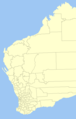 Blank map of Western Australia on which to place ranges

Article(s): Banksia sphaerocarpa
Request: This article needs a range map, but what would be great is to colour code it to the five subspecies involved. Here is the map for the species as a whole, while the five subspecies are mapped here (pale blue), here (yellow), here, here and here(orange) but see below. I have suggested some colours which are pertinent. Casliber (talk · contribs) 02:52, 11 January 2010 (UTC)
PS: The maps are on the official Western Australian Government herbarium website. As with the originals, limiting the map to western australia is prudent :) Casliber (talk · contribs) 02:55, 11 January 2010 (UTC)
PPS: Regarding the sphaerocarpa variety sphaerocarpa, see here - the northern part of its range is now pumilio (i.e. they do not co-occur). Casliber (talk · contribs) 00:40, 12 January 2010 (UTC)
Graphist opinion(s):
![]() Done now anyway. Casliber (talk · contribs) 22:01, 9 April 2010 (UTC)
Done now anyway. Casliber (talk · contribs) 22:01, 9 April 2010 (UTC)
Ukraine's border edit
-
 A blank map of Europe by Ssolbergj
_cropped.svg)
Article(s): Europe
Request: Please, correct Ukraine's border on this SVG map of Europe which is located on the main page of Europe. It has been cut in the South West and a huge piece of Ukraine's land belongs to Moldova, which is incorrect. The correct borders are on this map or on this. Thank you in advance. --UP9 7:51, 31 March 2010 (UTC)
Graphist opinion(s): I did a quick fix that at least makes it look ok at thumbnail size, if someone that's better at SVG than me wants improve on it please do. Kmusser (talk) 13:46, 31 March 2010 (UTC)
![]() Done
Done
- Now Moldovan-Ukrainian border has to be corrected (southern Moldovan tip especially), see File:Location_Ukraine_Europe.png. Bogomolov.PL (talk) 21:37, 31 March 2010 (UTC)
Make more colourblind-friendly edit
-
 Gini coefficient

Article(s): Gini coefficient, several others
Request: Could the colours be made more distinct from each other, especially for .55-59 and no data? I'm somewhat colourblind, and (although I can guess) I can't be sure whether Brazil is no data or .55-59. Nyttend (talk) 15:15, 4 April 2010 (UTC)
Graphist opinion(s): ![]() Done Hope that is better for you :D Fallschirmjäger ✉ 23:46, 18 April 2010 (UTC)
Done Hope that is better for you :D Fallschirmjäger ✉ 23:46, 18 April 2010 (UTC)
Anasazi edit

Article(s): Anasazi
Request: remove border; for some reason, this map comes up in parts, strange coding?... Chris (クリス • フィッチュ) (talk) 09:08, 11 April 2010 (UTC)
Graphist opinion(s): Done. The features were ungrouped, but I didn't see anything weird in there. Kmusser (talk) 18:37, 13 April 2010 (UTC)
Article(s): Free b
Request: Free replacement needed. OpenStreetMap coverage of the area is plentiful, so this shouldn't prove too difficult. 81.111.114.131 (talk) 17:34, 20 February 2010 (UTC)
Graphist opinion(s):
-
 first attmpe

Ok, I've made a preliminary version. Can someone confirm if the route and station locations are correct? The route might be correct but I'm pretty sure some of the stations are in the wrong places. If you tell me what's wrong it should be easy enough to move the stations to the right spot. TastyCakes (talk) 06:29, 15 April 2010 (UTC)
- Looks pretty good to me, only thing I see that's missing is the loop through the central bus station along Wood St., it's a bit ambiguous on [3], but pretty clear on [4] - I think the Wood St. stop should be more or less where the blue bus icon is on openstreetmap. Kmusser (talk) 19:09, 22 April 2010 (UTC)
- Ah yes, I see that now. I'll try and fix that tomorrow... TastyCakes (talk) 00:40, 23 April 2010 (UTC)
Failed state edit

Article(s): Failed state
Request: needs to be updated to include 2008 and 2009... Chris (クリス • フィッチュ) (talk) 11:07, 19 April 2010 (UTC)
Graphist opinion(s): Looks like this was already done, File:Failed-states-index-loop-2009.gif, or were you looking for something else? Kmusser (talk) 19:18, 22 April 2010 (UTC)
- That's the one!--Chris (クリス • フィッチュ) (talk) 01:59, 23 April 2010 (UTC)
Bog Turtle Distribution Map edit


Article(s): Bog turtle
Request: I was here once before to have the first image (a crude drawing on a white sheet of paper) transformed into the beautiful map being used in the current Bog turtle article. However, this article is a current featured article candidate and a concern has been left that, since this is a map of a species' distribution, it should be shown on a geographical map as opposed to a political map. I am leaving this here for two reasons: does anyone agree with the concern, and if there is merit to it and it deserves a change, for it to go ahead and be changed. NYMFan69-86 (talk) 23:23, 17 April 2010 (UTC)
Graphist opinion: I'm not sure what the commentator meant by geographical map (all maps are geographical) - if they meant topographic map, that would be cool but probably not necessary. Most of the existing distribution maps are on a political base - the point of having state lines on there is to give the reader a point of reference. We could replace them with something biological like ecoregion boundaries but I don't think they'd be a good reference then because most people won't recognize them. Kmusser (talk) 19:16, 22 April 2010 (UTC)
- I think he or she meant something similar to the distribution map in the taxonomy box of the Hawksbill turtle article. However, I am not sure this is the best solution in our case since the map is in such a concentrated area (the eastern U.S.). Would you agree?--NYMFan69-86 (talk) 19:36, 22 April 2010 (UTC)
- I definitely think you should stick with eastern U.S. - those would just be tiny dots on a world map. A case could be made for doing away with the state borders, but I'd be in favor of keeping them. Kmusser (talk) 20:00, 22 April 2010 (UTC)
- As am I. This will be mentioned to the person. Thanks so much for your advice. This request can be removed or deemed fixed.--NYMFan69-86 (talk) 21:06, 22 April 2010 (UTC)
- As well as the inclusion of state borders, they might mean how Canada has been left off. I think that's a little unusual in a species distribution map, even if it is only found in America. TastyCakes (talk) 12:21, 23 April 2010 (UTC)
- Yeah, adding Canada for more context would be an improvement. I don't have time to tackle that at the moment though. Kmusser (talk) 13:50, 23 April 2010 (UTC)
- This discussion has actually been had before, that's why the current caption reads "Bog turtle distribution. The range does not extend beyond the Canada–US border." People seem content with that.--NYMFan69-86 (talk) 01:28, 24 April 2010 (UTC)
- Yeah, adding Canada for more context would be an improvement. I don't have time to tackle that at the moment though. Kmusser (talk) 13:50, 23 April 2010 (UTC)
- As well as the inclusion of state borders, they might mean how Canada has been left off. I think that's a little unusual in a species distribution map, even if it is only found in America. TastyCakes (talk) 12:21, 23 April 2010 (UTC)
- As am I. This will be mentioned to the person. Thanks so much for your advice. This request can be removed or deemed fixed.--NYMFan69-86 (talk) 21:06, 22 April 2010 (UTC)
- I definitely think you should stick with eastern U.S. - those would just be tiny dots on a world map. A case could be made for doing away with the state borders, but I'd be in favor of keeping them. Kmusser (talk) 20:00, 22 April 2010 (UTC)
- I think he or she meant something similar to the distribution map in the taxonomy box of the Hawksbill turtle article. However, I am not sure this is the best solution in our case since the map is in such a concentrated area (the eastern U.S.). Would you agree?--NYMFan69-86 (talk) 19:36, 22 April 2010 (UTC)
Pyu edit

![[1]](http://atschool.eduweb.co.uk/chatback/images/europe.gif)
![[2]](http://studentweb.cortland.edu/cara.blake/miniproj1/map%20of%20Europe.jpg)
![[3]](https://en.wikipedia.org/wiki/File:Freebroute.jpg)
Article(s): Pyu
Request: transparent background... Chris (クリス • フィッチュ) (talk) 18:16, 22 April 2010 (UTC)
Graphist opinion(s): Done. Kmusser (talk) 19:23, 22 April 2010 (UTC)
- Thank you, can you trim a little off the sides? --Chris (クリス • フィッチュ) (talk) 02:07, 23 April 2010 (UTC)
- Perfect, thank you! --Chris (クリス • フィッチュ) (talk) 12:41, 24 April 2010 (UTC)