Wikipedia:Featured picture candidates/India roadway map
India roadway map edit

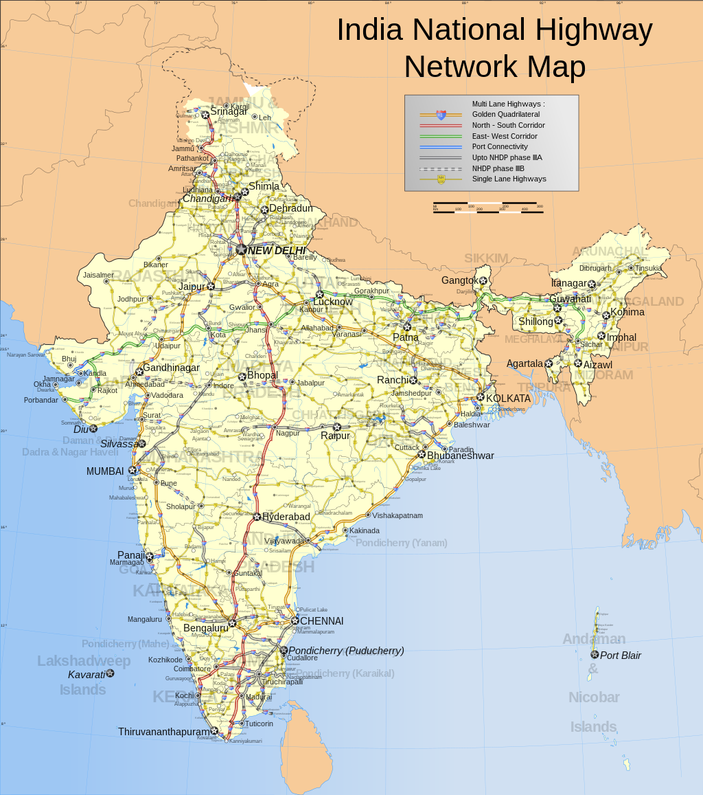
Nomination is pretty self explanatory. This is the only complete and comprehensive map of the Indian national highway network found on the entire web.
Appears in Indian highways, Golden Quadrilateral, National Highways Authority of India, National Highways Development Project, List of National Highways in India.
There are two versions, one is just the road network and the other one is imposed on a population density map and appears in Indian highways.
- Nominate and support
both versions. - PlaneMad|YakYak 10:50, 19 October 2006 (UTC) - Oppose. Disagree with format of map (svg). A static map like this one shouldn’t be scalable: if you reduce the scale, the lettering and other cartographic symbols might become illegible and the image crowded; if you enlarge it, you are suggesting a precision (and accuracy) that the map doesn’t have. Note that topographic maps of the same region, but with different scales, have different detail and symbology (different levels of “generalization”, as cartographers say). Also, the image available for Wikipedia articles (and for this analysis) is too small to appreciate the details. I will review my opinion if map is presented with a specific size and scale -- Alvesgaspar 11:28, 19 October 2006 (UTC)
- Comment, IMO the advantage of using svg is to pack more details into the file, as an end user can download it and zoom in to see the details which is not possible for a png map. I have used specific sizes for the fonts so that state names, state capitals, commercial cities and tourist towns are visible in the raster version. Only to see the smaller towns do you nedd to open the svg file -- PlaneMad|YakYak 11:37, 19 October 2006 (UTC)
- SVGs specify a recommended display size; there's no need to use a raster-based format to address this problem. And note that more detail doesn't necessarily mean larger size; on high-DPI printers, more detail is necessary to sharply print the same size, and SVG provides that. Redquark 13:22, 19 October 2006 (UTC)
- Question and Comment Which is the image under evaluation? If both, please create fresh nomination. As for the size of the images, I'm still complaining that it is not enough for the present purpose (reviewing) and for normal use in an article. As far as I know, the MSI Explorer does not suppor svg and it is not practical to download the file just to look at it (in the case the user has an application capable of reading svg, which I don't). If, as Redquark states, svg's specify a recommended size, that size should be immediately available and a scale should be specified for it. -- Alvesgaspar 15:05, 19 October 2006 (UTC)
- Comment Cannot vote as there are 2 pictures. One picture per nom please. HighInBC 15:36, 19 October 2006 (UTC)
- Support Excellent. HighInBC 19:20, 19 October 2006 (UTC)
- Comment You dont necessarily need a svg plugin (native support with IE7 firefox and opera9), you can view the enlarged raster version as i mentioned above -- PlaneMad|YakYak 18:00, 19 October 2006 (UTC)
- Very very few Wikipedia users (not us editors, but the folks who actually use Wikipedia) have SVG support and therefore cannot view this at the proper magnification. MapMaster 21:53, 19 October 2006 (UTC)
- Strong support. This is what a map on Wikipedia should look like. It's very informative and the legend on the description page makes it even better. The SVG format is just perfect for this. –Gustavb 19:12, 19 October 2006 (UTC)
- Support. Great map, right format! I just cannot believe anyone would ask for a raster version. As stated in the image upload instructions the peferred (and technologically superior) format for this kind of illustration is SVG. Benefits of SVG include easier editing, including translations of text labels (there are more Wikipedias than just the English one), and high quality printing (SVG provides infinite resolution). --Dschwen 21:29, 19 October 2006 (UTC)
- Support because this is a beautiful map. However, for most Wikipedia viewers it is not at all useful. If you view it on anything but the largest size, you just can't read anything. But in order to view it at the proper size for reading, you need some sort of SVG support/plug-in. In fact, when I try to view at the proper size on my computer without SVG support, my browser (IE6) abends. Nonetheless, the map is beautiful at any size and I believe maps need more support here in Wiki-land. MapMaster 21:53, 19 October 2006 (UTC)
- Support, with hesitation; Alvesgaspar brings up a good point about being overly-precise. But I nonetheless think this is one of the few maps that qualify for FP. It's highly detailed, in SVG, and looks professional. --Tewy 00:00, 20 October 2006 (UTC)
- Comment - I’m not being overly precise. It is easy to agree that this is a beautiful map. But aesthetics is not the only criterion to be taken in consideration (its not even a very relevant one in this context). In Cartography accuracy (positional accuracy and also thematic accuracy) are key quality elements we should consider when evaluating a map. Of course we really don’t have here the means, or the knowledge, to assess the accuracy of maps. But at least we should look at some basic cartographic principles, instead of only beauty, when assigning a FP quality tag to a map. One of the most important is the objective of the map because it has direct consequences on the way it is constructed: is it designed to be put in a wall, to be used in a computer display or to be pasted, as an illustration, in a A4 page? My insistence that a size and a scale should be clearly stated is not a futile obstinacy: I was just trying to get an answer to that question. I don’t really care about the format of the picture file provided it serves well our objectives. It should be clear by now that I’m not an old reactionary trying to avoid the use of superior technologies. I am a map lover and believe, like others, that “maps need more support here in Wiki-land”. - Alvesgaspar 08:56, 20 October 2006 (UTC)
- PS. Another informatiom that should be given in the legend is the map projection. It looks like an azimuthal projection (either equidistant or equal-area) but I'm not sure. - Alvesgaspar 10:16, 20 October 2006 (UTC)
- Comment The map is primarily a computer document, but you need at least an A3 print to see the details, i guess. But the beauty of the format is that however large you scale it up, it wont deteriorate one bit. You must understand that India is one huge country and much like the US but with hundreds of more cities. There is now way i can make a map of the primary road network that can be appreciated in a thumbnail, you have to view the full version to get an idea of the scale of it all, much like this one. And the SVG format was a necessity to make a map of this kind. If i had made this map in PNG of appropriately high resolution, it will be over 3mb in size. And being SVG, the map is open source. Image:India_roadway_map.svg#SVG_Support. Projection has been mentioned under notes. -- PlaneMad|YakYak 10:44, 20 October 2006 (UTC)
- Weak support very meticulous and detailed map. However, I am not that fond of how the state names are a tint and run across other text. However, it is still encyclopedic, high resolution, and frankly overwhelmingly detailed.--Andrew c 16:01, 20 October 2006 (UTC)
- Comment-I do not understand why the Raster version on the image page is a completely different image than the full size SVG. The state names do not show up, the key is compeltely different, the highway lines are different. What's the deal with that?--Andrew c 16:04, 20 October 2006 (UTC)
- Support. mstroeck 21:49, 21 October 2006 (UTC)
- Support. Extremely detailed map. Prefessional work by Planemad. An additional legend, with explaination of green, yellow, and red coloured roads would be great. — Ambuj Saxena (talk) 19:37, 22 October 2006 (UTC)
- Comment Will do that when i get back home next week. -- PlaneMad|YakYak 01:42, 23 October 2006 (UTC)
Promoted Image:India roadway map.svg howcheng {chat} 16:45, 27 October 2006 (UTC)