Wetheron is a rural town and locality in the North Burnett Region, Queensland, Australia.[2][3] In the 2021 census, the locality of Wetheron had a population of 40 people.[1]
| Wetheron Queensland | |||||||||||||||
|---|---|---|---|---|---|---|---|---|---|---|---|---|---|---|---|
 Wetheron | |||||||||||||||
| Coordinates | 25°32′45″S 151°43′07″E / 25.5458°S 151.7186°E | ||||||||||||||
| Population | 40 (2021 census)[1] | ||||||||||||||
| • Density | 0.32/km2 (0.82/sq mi) | ||||||||||||||
| Postcode(s) | 4625 | ||||||||||||||
| Area | 125.8 km2 (48.6 sq mi) | ||||||||||||||
| Time zone | AEST (UTC+10:00) | ||||||||||||||
| LGA(s) | North Burnett Region | ||||||||||||||
| State electorate(s) | Callide | ||||||||||||||
| Federal division(s) | Flynn | ||||||||||||||
| |||||||||||||||
Geography
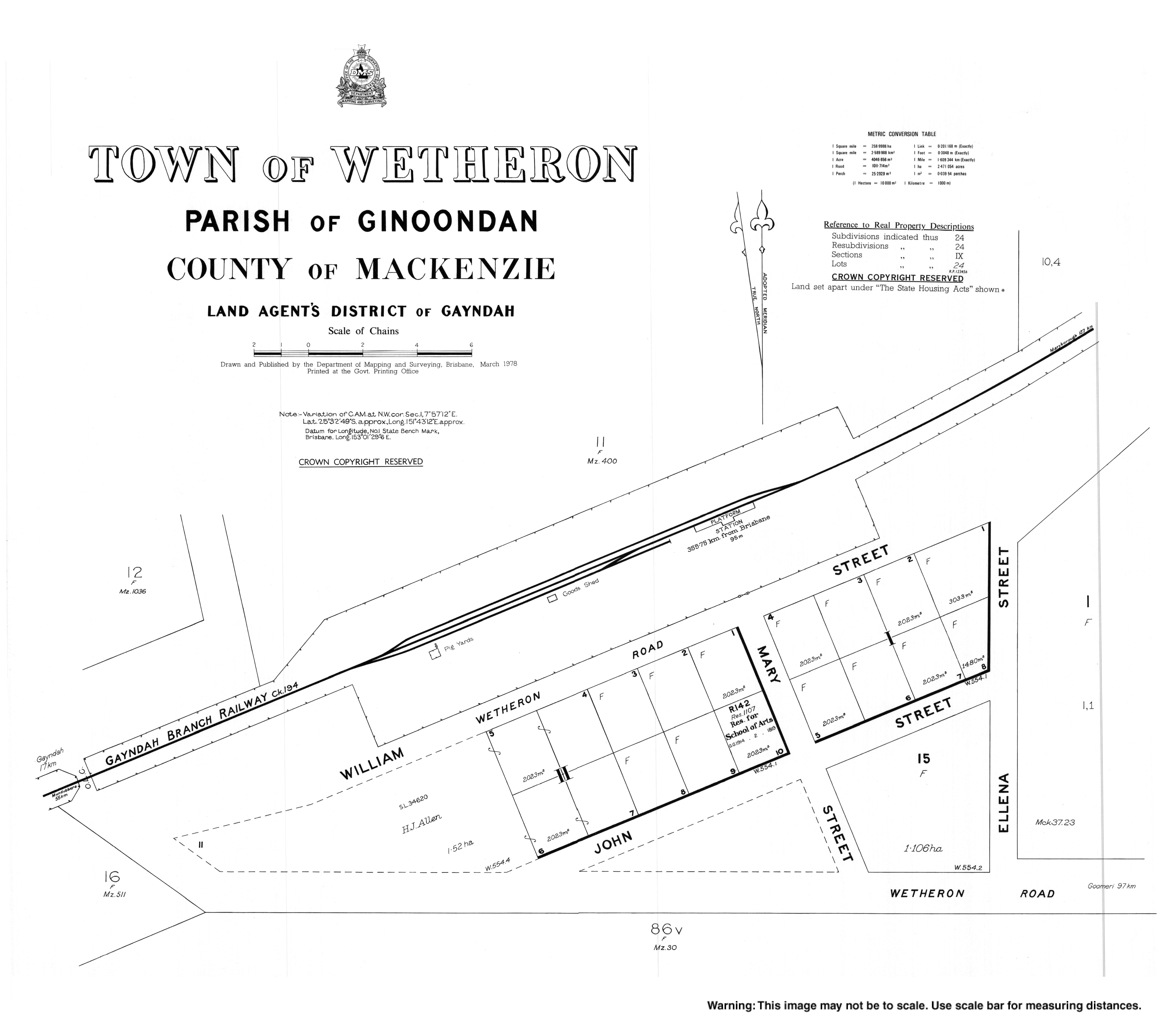
editThe Mungar Junction to Monto Branch Railway passes through Wetheron.[4] The town was served by the Wetheron railway station (25°32′40″S 151°43′04″E / 25.54444°S 151.71778°E)[5]
A report by R. W. Winks of the Department of Agriculture, Brisbane, surveying for the proposed Degilbo to Gayndah railway line extension, dated 10 November 1897 stated:- "The first really good piece of country of any extent begins some little distance from the coach stage at Wetheron, Two Mile, extending beyond the head station and running thence in a south-westerly direction to Oakey Creek. This belt, which takes in the whole of what was the Byrnestown and part of the Resolute and Bon Accord Groups, about 8 miles (13 km) in length, and varying in breadth from 3 to 4 miles, is on the whole good land. It is principally composed of fine, black and chocolate soil ridges, even in contour, and in many places lightly timbered with broad-leafed ironbark and a kind of bloodwood. In some parts there is scarcely any timber, from which fact a portion of this zone is known locally as the Wetheron Clear Lands. Want of water is the chief drawback, but from some wells I saw on what was once group property, it would appear that good water can be obtained by comparatively shallow sinking. The average depth of the wells seemed about 40 feet (12 m)."[6]
History
editEuropean settlement in the Wetheron area began in 1845, when William Humphreys and Henry Arthur Herbert took up a run of crown land on the south bank of the Burnett River.[7] The estimated 24,000 acres (9,700 ha) was about 12 miles (19 km) from Gayndah and 70 miles (110 km) from Maryborough and was known as Wetheron Head Station.[8] This was transferred to William Humphreys solely in 1851, along with the Ginoondam run.[9] Chinese labour was employed at Wetheron during Humphreys tenure.[10][11]
When Humphreys advertised the Wetheron runs for sale in 1857 the head station was described as consisting "of a comfortable verandah house, shingled, and containing 4 rooms and pantry, a kitchen, store, and meat store, overseer's house, shingled; woolshed, fitted with yards, shearer's house, shingled; two labourer's huts; a good two rail horse paddock; small cultivation paddock (3 rail); garden, stockyard, milking yard, pigsties, etc. There are seven out stations, with substantial huts, and yards or hurdles at each of them." The run consisted of Wetheron Head Station, Ginoondam, Wateranga and Gooroolballam stations.[8]
The partnership of Hon. Berkeley Basil Moreton and Osmond de Preaux Brock acquired the Station. Berkeley Moreton's brother Seymour Moreton replaced Brock in 1861.[12]
The co-operative groups of Bon Accord, Byrnestown and Resolute settled on sites on a Wetheron run resumption in 1894.[13][14]
The Wetheron Run had been reduced to 15,360 acres (6,220 ha) by 1901.[15]
In 1905 more parts of Wetheron were being opened up as agricultural farms and unconditional selections, and in 1908 the leasehold expired.[16] In 1905 when the Wetheron Railway Station and the line to Maryborough opened the township consisted of a newly-built hotel, kept by Mr. A. A. Morgan, and a fruit shop and general store.[17] The Mungar Junction to Monto railway line opened between Wetheron to Gayndah on 16 December 1907.[18]
Wetheron State School opened on 24 January 1916. It closed on 31 December 1963.[19] It was on John Street (25°32′47″S 151°43′12″E / 25.54631°S 151.71999°E).[20][21][4]
In November 1925, the Anglican Archdiocese of Brisbane provided a loan of £150 to establish a church in Wetheron.[22] Mrs Helen Gray donated a quarter-acre of land and a parish hall was erected by George James Bellert. The hall was officially opened on 5 May 1926.[23] St John's Anglican Church was dedicated on 11 December 1927 by Venerable William Powning Glover, Archdeacon of Toowoomba.[24] It is now closed.[25]
Sefton Provisional School opened on 1925 and closed on 1926.[26]
Demographics
editIn the 2016 census, the locality of Wetheron had a population of 46 people.[27]
In the 2021 census, the locality of Wetheron had a population of 40 people.[1]
Education
editThere are no schools in Wetheron. The nearest primary schools are Gayndah State School in neighbouring Gayndah to the south-west and Coalstoun Lakes State School in Coalstoun Lakes to the south-east. The nearest secondary school is Burnett State College in Gayndah.[4]
References
edit- ^ a b c Australian Bureau of Statistics (28 June 2022). "Wetheron (SAL)". 2021 Census QuickStats. Retrieved 28 February 2023.
- ^ "Wetheron – town in North Burnett Region (entry 37158)". Queensland Place Names. Queensland Government. Retrieved 16 May 2020.
- ^ "Wetheron – locality in North Burnett Region (entry 45424)". Queensland Place Names. Queensland Government. Retrieved 16 May 2020.
- ^ a b c "Queensland Globe". State of Queensland. Retrieved 24 December 2023.
- ^ "Wetheron railway station (entry 37160)". Queensland Place Names. Queensland Government. Retrieved 20 August 2016.
- ^ "REPORT BY R. W. WINKS". Maryborough Chronicle, Wide Bay and Burnett Advertiser. No. 7, 824. Queensland, Australia. 2 December 1897. p. 3. Retrieved 11 October 2022 – via National Library of Australia.
- ^ "CROWN LANDS BEYOND THE SETTLED DISTRICTS". New South Wales Government Gazette. No. 77. New South Wales, Australia. 19 June 1850. p. 932. Retrieved 4 August 2022 – via National Library of Australia.
- ^ a b "Advertising". Empire. No. 1868. New South Wales, Australia. 1 January 1857. p. 7. Retrieved 4 August 2022 – via National Library of Australia.
- ^ "Government Gazette". The Maitland Mercury and Hunter River General Advertiser. Vol. IX, no. 734. New South Wales, Australia. 16 July 1851. p. 4. Retrieved 4 August 2022 – via National Library of Australia.
- ^ Queensland State Archives, Item ID ITM212593 pp 123, 125
- ^ "Classified Advertising". The Moreton Bay Courier. Vol. IX, no. 441. Queensland, Australia. 25 November 1854. p. 3. Retrieved 15 August 2023 – via National Library of Australia.
- ^ "Foxs History Queensland 2d" (PDF). UQ eSpace. 1 August 2022. p. 7/824. Retrieved 1 August 2022.
- ^ "COOPERATIVE COMMUNITIES IN THE BURNETT". Maryborough Chronicle, Wide Bay and Burnett Advertiser. No. 6, 627. Queensland, Australia. 17 January 1894. p. 2. Retrieved 5 August 2022 – via National Library of Australia.
- ^ "Co-operative Groups". Gympie Times And Mary River Mining Gazette. Vol. XXVI, no. 3174. Queensland, Australia. 25 January 1894. p. 3. Retrieved 5 August 2022 – via National Library of Australia.
- ^ "THE GAYNDAH RAILWAY". Maryborough Chronicle, Wide Bay and Burnett Advertiser. No. 8, 868. Queensland, Australia. 16 April 1901. p. 2. Retrieved 11 October 2022 – via National Library of Australia.
- ^ "LAND SETTLEMENT". Brisbane Courier. 14 October 1905. Retrieved 4 August 2022.
- ^ "IN THE BURNETT DISTRICT". The Queenslander. No. 2082. Queensland, Australia. 3 February 1906. p. 41. Retrieved 4 August 2022 – via National Library of Australia.
- ^ "Railway stations and sidings – Queensland". Queensland Open Data. Queensland Government. 2 October 2020. Archived from the original on 5 October 2020. Retrieved 5 October 2020.
- ^ "Opening and closing dates of Queensland Schools". Queensland Government. Retrieved 19 August 2016.
- ^ "Gayndah" (Map). Queensland Government. 1944. Retrieved 24 December 2023.
- ^ "County of Mackenzie" (Map). 1922. Retrieved 24 December 2023.
- ^ "THE CHURCHES". Daily Standard. No. 4009. Queensland, Australia. 14 November 1925. p. 2. Retrieved 1 July 2020 – via National Library of Australia.
- ^ "WETHERON FUNCTION". Maryborough Chronicle, Wide Bay and Burnett Advertiser. No. 17, 613. Queensland, Australia. 11 June 1926. p. 2. Retrieved 1 July 2020 – via National Library of Australia.
- ^ "NEWS OF THE CHURCHES". The Telegraph. No. 17, 173. Queensland, Australia. 17 December 1927. p. 4. Retrieved 1 July 2020 – via National Library of Australia.
- ^ Anglican Church of Southern Queensland. "Closed Churches". Archived from the original on 3 April 2019. Retrieved 3 April 2019.
- ^ Queensland Family History Society (2010), Queensland schools past and present (Version 1.01 ed.), Queensland Family History Society, ISBN 978-1-921171-26-0
- ^ Australian Bureau of Statistics (27 June 2017). "Wetheron (SSC)". 2016 Census QuickStats. Retrieved 20 October 2018.
External links
edit- "Town map of Wetheron". Queensland Government. 1978. Archived from the original on 1 July 2020.