Villeneuve is a rural town and locality in the Somerset Region, Queensland, Australia.[2][3] In the 2021 census, the locality of Villeneuve had a population of 193 people.[1]
| Villeneuve Queensland | |||||||||||||||
|---|---|---|---|---|---|---|---|---|---|---|---|---|---|---|---|
 Paddocks in Villeneuve with Mount Archer in the background, 2015 | |||||||||||||||
 Villeneuve | |||||||||||||||
| Coordinates | 26°57′42″S 152°37′54″E / 26.9616°S 152.6316°E | ||||||||||||||
| Population | 193 (2021 census)[1] | ||||||||||||||
| • Density | 29.69/km2 (76.9/sq mi) | ||||||||||||||
| Postcode(s) | 4514 | ||||||||||||||
| Area | 6.5 km2 (2.5 sq mi) | ||||||||||||||
| Time zone | AEST (UTC+10:00) | ||||||||||||||
| Location | |||||||||||||||
| LGA(s) | Somerset Region | ||||||||||||||
| State electorate(s) | Nanango | ||||||||||||||
| Federal division(s) | Blair | ||||||||||||||
| |||||||||||||||
Geography
edit
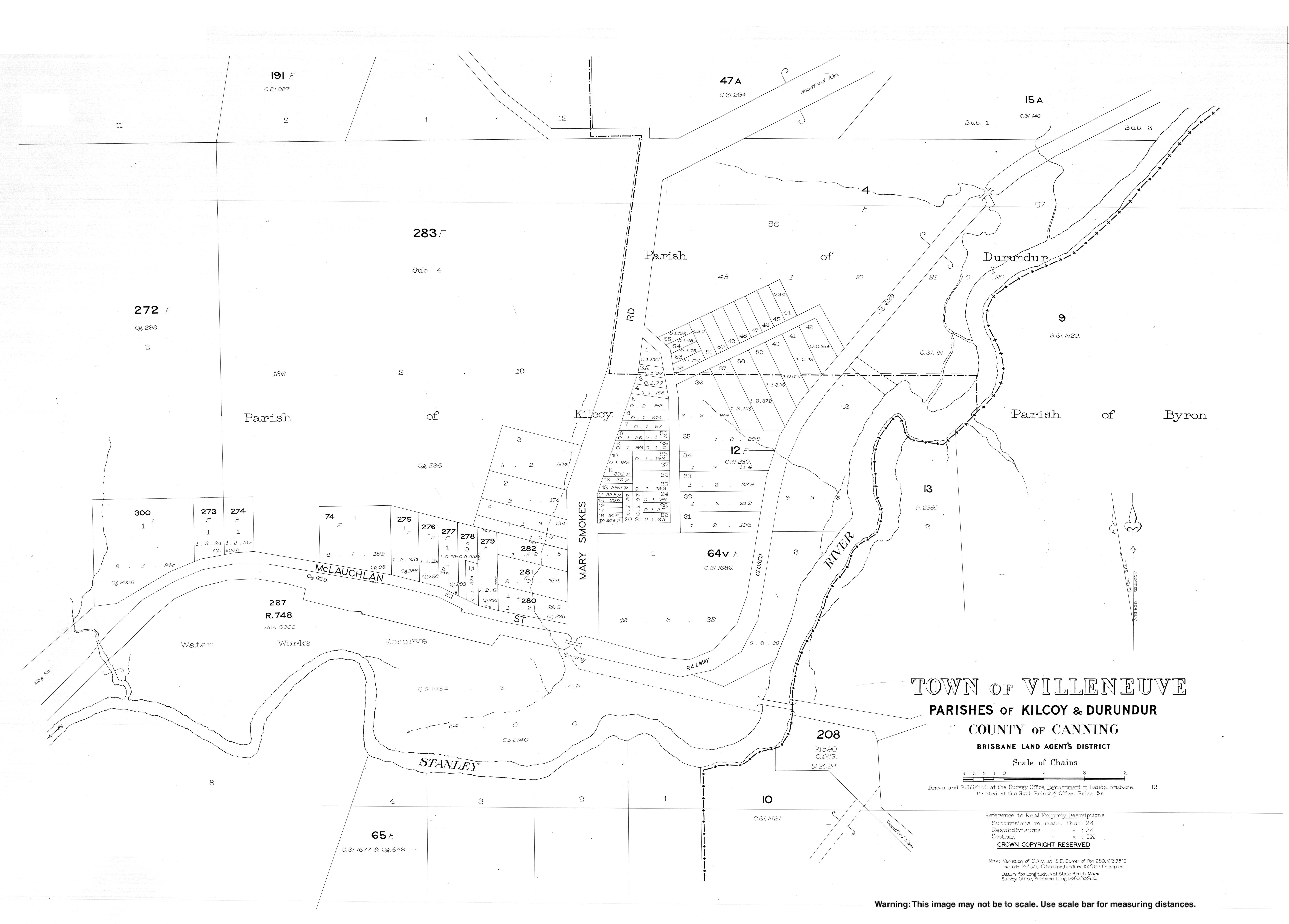
A section of the northern boundary of Villeneuve follows the D'Aguilar Highway. The eastern and southern boundaries of the locality are the Stanley River and Lake Somerset created by the Somerset Dam impounding the Stanley River.[4]
The land use is a mix of rural residential (mostly near the lake) and grazing on native vegetation.[4]
The Kilcoy railway line passed through Villeneuve which was served by two railway stations (now both dismantled):
- Villeneuve railway station (26°57′46″S 152°37′39″E / 26.9627°S 152.6275°E)[5]
- Royston railway station (26°57′16″S 152°38′54″E / 26.9544°S 152.6482°E)[5]
History
edit
The town is named after the Villeneuve railway station, which in turn took its name from Frank Villeneuve Nicholson, owner of the property Villeneuve.[3]
Farming was established at Villeneuve in the late 1870s.[6]
Villeneuve Provisional School opened on 30 May 1887 with a new building erected in 1888 which it shared with the Anglican Church. In 1902, it was relocated to Westvale and renamed West Vale Provisional School.[7]
St Barnabas' Anglican Church was dedicated on Sunday 2 September 1888 by local rector Reverend J.F. Leighton. It occupied shared premises with the provisional school with the school room being the nave of the church with a chancel being added for church services.[8][9][10] It closed circa 1961.[11]
A second Villeneuve Provisional School was built in 1902, which became Villeneuve State School on 1 January 1900. It closed in 1960.[7] It was to the immediate north of the Villeneuve railway station at 1 Mclauchlan Street (26°57′41″S 152°37′36″E / 26.9615°S 152.6268°E).[12]
As a result of the creation of the Somerset Dam (completed in 1958), some of Villeneuve is now inundated.[6]
Demographics
editIn the 2016 census, the locality of Villeneuve had a population of 179 people.[13]
In the 2021 census, the locality of Villeneuve had a population of 193 people.[1]
Education
editThere are no schools in Villenueve. The nearest government primary school is Kilcoy State School in Kilcoy to the west. The nearest government secondary school is Kilcoy State High School, also in Kilcoy.[4]
References
edit- ^ a b c Australian Bureau of Statistics (28 June 2022). "Villeneuve (SAL)". 2021 Census QuickStats. Retrieved 28 February 2023.
- ^ "Villeneuve – town in Somerset Region (entry 43021)". Queensland Place Names. Queensland Government. Retrieved 30 November 2019.
- ^ a b "Villeneuve – locality in Somerset Region (entry 44928)". Queensland Place Names. Queensland Government. Retrieved 30 November 2019.
- ^ a b c "Queensland Globe". State of Queensland. Retrieved 20 July 2023.
- ^ a b "Railway stations and sidings - Queensland". Queensland Open Data. Queensland Government. 2 October 2020. Archived from the original on 5 October 2020. Retrieved 5 October 2020.
- ^ a b "Kilcoy and Kilcoy Shire". Queensland Places. Centre for the Government of Queensland, University of Queensland. Retrieved 14 March 2014.
- ^ a b Queensland Family History Society (2010), Queensland schools past and present (Version 1.01 ed.), Queensland Family History Society, ISBN 978-1-921171-26-0
- ^ "DEDICATION OF AN ANGLICAN CHURCH AT VILLENEUVE". Queensland Times, Ipswich Herald And General Advertiser. Vol. XXVIII, no. 4096. Queensland, Australia. 11 September 1888. p. 4. Retrieved 6 July 2020 – via National Library of Australia.
- ^ "Church at Villeneuve". The Queenslander. Vol. XXXIV, no. 676. Queensland, Australia. 15 September 1888. p. 461. Retrieved 26 September 2020 – via National Library of Australia.
- ^ "Brisbane Diocesan Synod". The Queenslander. Vol. XXXIV, no. 676. Queensland, Australia. 15 September 1888. p. 454. Retrieved 6 July 2020 – via National Library of Australia.
- ^ Anglican Church of Southern Queensland. "Closed Churches". Archived from the original on 3 April 2019. Retrieved 3 July 2020.
- ^ "Moreton 40 Chain map AG2 series sheet 19 north" (Map). Queensland Government. 1932. Retrieved 20 July 2023.
- ^ Australian Bureau of Statistics (27 June 2017). "Villeneuve (SSC)". 2016 Census QuickStats. Retrieved 20 October 2018.