Varasova (Greek: Βαράσοβα) is a limestone mountain in the southern part of Aetolia-Acarnania in western Greece. It was known as Chalcis (Ancient Greek: Χαλκίς) in antiquity, and there was an ancient Aetolian town at its foot named Chalcis, Hypochalcis or Chalceia[2] (hence the name of the current administrative unit Chalkeia). It rises steeply from the coast of the Gulf of Patras to 917 m elevation.[1] It is situated just east of the mouth of the river Evinos, 3 km east of Galatas, 14 km east of Missolonghi and 18 km northwest of Patras. 8 km to its east is the mountain Klokova. There are several rock climbing routes on the steep south and southwest faces of the Varasova.[1]
| Varasova | |
|---|---|
 Varasova from Kryoneri | |
| Highest point | |
| Elevation | 917 m (3,009 ft)[1] |
| Coordinates | 38°21′49″N 21°35′31″E / 38.3635°N 21.592°E |
| Naming | |
| Pronunciation | Greek: [vaˈrasova] |
| Geography | |
 Varasova southern Aetolia-Acarnania | |
It is referred to as the Mount Athos of Rumelia or Western Greece, due to the large number of churches and monasteries (around 72) built in the Byzantine and the Ottoman period.[3] Several still exist today, including the 9th-18th century cave monastery of Agios Nikolaos near Kryoneri, which is only accessible by boat.[4]
Local tradition tells us that the Titans endeavoured to throw this rock into the sea, so that it might form a bridge between the two coasts; but the rock proved too heavy, and was dropped where we see it today.
Gallery
edit-
 East side of Varasova, Kato Vasiliki
 -
 Varasova from Patras
 -
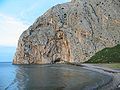
 Varasova from Kryoneri
 -
 Varasova, Kryoneri
 -
 Varasova from ancient Calydon
 -
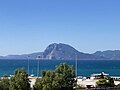 Mount Varasova very prominently viewed from Patras, Greece.
 -
 Varasova (and Klokova) viewed from Tsoukaleika.


References
edit- ^ a b c Oreivatein
- ^
 Smith, William, ed. (1854). "Chalcis". Dictionary of Greek and Roman Geography. Vol. 1. London: John Murray. p. 600.
- ^ Kryoneri tourist guide
- ^ Galatas tourist guide