User talk:Ratzer/Archive 2009
| This page is an archive of past discussions. Do not edit the contents of this page. If you wish to start a new discussion or revive an old one, please do so on the current talk page. |
Hi Ratzer, I hadn't come to my Wikipedia personal pages for several months, almost a year, as I'm rather busy in real life. So you're lucky I did see your rather recent comment on Gaua, esp. on the map. I had a quick look on your edits on Gaua, and saw nothing wrong. Regarding the map: I love drawing maps myself, and wouldn't mind doing it, but (1) I have little time these days, as I'm moving etc; (2) I haven't figured out how this can be done on Wikipedia maps (what software, etc.??) So I'd be interested to know how you do that. But if you wish to edit the (very bad) map that's already there, then that's a good idea. OK now I do have a scan of an IGN map, which is good for the topography; but then it's very bad (as usual) with toponymy, and (being a linguist myself) I'm willing to propose better spellings for village names etc. I guess I would need you email address and you would need mine, I can't remember if we get these easily from our personal pages? Or should I indicate it in a message here? [I don't connect often here, so I hope I won't forget to check my new messages]. Cheers, Womtelo (talk) 02:36, 18 January 2009 (UTC).
You maybe interested in the Article Rescue Squadron

|
Hello, Ratzer. Based on the templates on your talk page, please consider joining the Article Rescue Squadron. Rescue Squadron members are focused on rescuing articles from deletion, that might otherwise be lost forever. I think you will find our project matches your vision of Wikipedia. You can join >> here <<. |
Welcome to the Article Rescue Squadron!

You wrote on the membership list: "I hope to help with geographical articles pending deletion" Most articles tag for rescue involve entertainment. But there was a huge debate recently about geographical cordinates being deleted.
Here are some suggestions:
- Maybe you can ask editors like User:DGG to point you to these articles and AfDs. User:DGG is probably the most well respected and influential intellectual of the article saving movement.
- You can join and monitor several geographic groups, here: Category:WikiProject_invitation_templates which monitor regional deletions. Even better is: Category:Wikipedia_deletion_sorting_by_country
When an article is put up for deletion which you feel is worthy of inclusion, you can add the {{rescue}} tag below the AfD tag. - You can monitor Wikipedia:Articles_for_deletion#Current_discussions around 120 articles everyday are put up for deletion, the majority are deleted. There are currently 980 articles up for deletion right now, (this number listed here is dynamic, and will change)
- See also the essay Wikipedia:Inherent notability, a term used often, were "geography based subjects" tend to be inherently notable, and so therefore they can not be deleted.
Let me know how else I can help! If you have any questions, don't hestitate to ask! Ikip (talk) 02:19, 24 February 2009 (UTC)
Welcome to ARS!

Hi, Ratzer, welcome to the Article Rescue Squadron WikiProject! We are a growing community of Wikipedia editors dedicated to identifying and rescuing articles and content that have been nominated for deletion. Every day hundreds of articles are deleted, many rightfully so. But many concern notable subjects and are poorly written, ergo fixable, and should not be deleted. We try to help these articles and content to quickly improve and address the concerns of why they are proposed for deletion. This covers a lot of ground and your help is appreciated!
- WikiProject Article rescue squadron's (ARS) main aim is to help improve Wikipedia articles and content. If someone seeks help, please try to assist if you are able. Likewise feel free to ask for help, advice and clarification.
- Sometimes we are asked to help rescue articles by people new to our notability and sourcing policies. If the article is not fixable we can help explain why and offer alternatives. Sometimes editors who are new to Wikipedia may perceive the deletion of "their" article as discouraging. Encourage civility and maybe even {{welcome}} them if they have only been templated with deletion messages.
- The Articles for deletion (AfD) discussion is where the concerns regarding each article are brought up and addressed. To be an effective member of the project you need to know how AfD works as well as how to improve articles. Introduction to deletion process gives a good overview and some good advice for newcomers to deletion.
- Our primary work is improving Wikipedia articles and content. A more dynamic list with article links and descriptions are located at our rescue list.
- If you have another language besides English, please consider adding yourself to the list of translators available. Articles and sources that use non-English languages often need translation for those of us who cannot translate for ourselves.
- Many important discussions take place on the project's main discussion page; it is recommended that you watchlist it.
If you have any questions, feel free to ask on the talk page, and we will be happy to help you.
And once again — Welcome! ~~~~
Blood Falls: for your information
The main photograph image of Blood Falls has been added on 16:44, 20 April 2009 (UTC) on the Wikipedia:Picture peer review page to be proposed as a candidate for Wikipedia:Featured Pictures. See Wikipedia:Picture peer review/BloodFalls to give a comment or to support the proposal. Thanks — Shinkolobwe (talk) 19:23, 23 April 2009 (UTC)
Tasmania
Overall = thanks for the good work - however the townships of the Central highlands could be easily misleading - they might show up on a database - but hey - I could show you the maps that I have of the west coast surveyed townships - and there is nothing there, (I have photos of some of the finer points of the darwin and crotty townsites - nothing of anything that would identify the former towns at all). So please understand that where bureaucracies and systems identify surveyed townsites in central and western tasmania - it is a name and literally nothing else SatuSuro 02:25, 10 June 2009 (UTC)
- Hi Suro, thanks for your input. Surely, the Central Highlands and West Coast are very empty by any standard, at 0.3 and 0.5 people per square kilometre. But still, a few thousand people live in each of those municipalities, which makes a few hundred per township. It is exactly in this vast emptyness to know where do a few people live, and where is a small village or hamlet, and how big is it. Below the municipality level, the Australian Bureau of Statistics offers population figures for what it calls State Suburbs (I still might retrieve those and present them in the article), but unfortunately not for the townships or population centers like Hamilton and Ouse, for which you find widely different population figures in the internet.--Ratzer (talk) 08:34, 10 June 2009 (UTC)
OK if youre working from the ABS stats they tend not to use 'ghost towns' in their tabulations - thats fine - keep up the good work! - as for Hamilton and Ouse their populations (ie settlements next to the Lyell highway) are now very small - however the adjacent district populations might be pulled in by ABS criteria - anyways well done so far! SatuSuro 11:16, 10 June 2009 (UTC)
Dubayrah
Hello Ammar Shaker, the largest town of the Wadi Halfa Salient before its flooding by Lake Nasser was Dubayrah (after which town the map sheet in the article is named). How is that written in Arabic? Thank you.--Ratzer (talk) 19:57, 12 June 2009 (UTC)
- I personally never heard about this city but It could be:
- (1) دبيرة - Dubayrah
- (2) الدبيرة - The Dubayrah (Because most arabic city names inclues THE)
- (3) ضبيرة - Dubayrah with Heavy D
- (4) الضبيرة - The Dubayrah with Heavy D
- I assume the second one is the correct spelling but to make sure please ask a sudanese or egyptian national maybe they have a better back ground. A M M A R 08:27, 13 June 2009 (UTC)
- Thank you Ammar, a friend in the AR-WP decided that (1) is the correct one, ar:ويكيبيديا:سفارة#Dubayrah_in_Arabic.3F.--Ratzer (talk) 14:49, 15 June 2009 (UTC)
Jellyfish Lake
Hey Ratzer, I saw your edits to Jellyfish Lake, and was wondering what your sources were for the new infobox figures? Thanks for any info. — Huntster (t • @ • c) 05:07, 27 June 2009 (UTC)
- Well the volume is calculated from area and average depth. The information that it is on Eil Malk island is from de-WP. Eil Mail is also called Mecherchar. In Wikimapia it can be verified that the lake is located on that island. Here is also a detailed map of the island, unfortunately without the name of the lake indicated. I am planning to add the name to the map (it's public domain) and upload it to commons.--Ratzer (talk) 21:53, 28 June 2009 (UTC)
- I'm going to have a go at finding sources for all the numbers presented in the article, though it's not easy to find material...strange, considering its popularity. In the future, I'd ask that you avoid making such calculations like you did with volume...that's considered original research and isn't allowed. The name of the island is also something of an oddity...most maps I've seen label it as Mecherchar, and it's southeast spar is usually labeled "Eil Malk". Yet Eil Malk is the islands common name, as seen used by the U.S. Navy. I've been interested in this subject for a while, and hope to rewrite the lake's article, and perhaps create one for the island itself. Cheers :) — Huntster (t • @ • c) 04:29, 29 June 2009 (UTC)
- I strongly dispute the contention that executing a simple calculation, be it volume of a lake or population density of a city, is original research. This is ridiculous. I have done hundreds and seen thousands of such calculation in the WP, without anyone ever calling this OR. Other than that, we seem to be in perfect agreement :-)--Ratzer (talk) 11:31, 29 June 2009 (UTC)
- Speaking about a new article for Eil Malk, there is already a short one on de-WP that I can translate to English, for a start.--Ratzer (talk) 11:38, 29 June 2009 (UTC)
- You might want to verify the dimensions and area of the lake with [1] Geotools, which allows you to perform distance and area measurements. This is also not considered OR. It's only the cloud that obscures part of the island will introduce a slight inaccuracy into the area measurement.--Ratzer (talk) 11:45, 29 June 2009 (UTC)
- I'm going to have a go at finding sources for all the numbers presented in the article, though it's not easy to find material...strange, considering its popularity. In the future, I'd ask that you avoid making such calculations like you did with volume...that's considered original research and isn't allowed. The name of the island is also something of an oddity...most maps I've seen label it as Mecherchar, and it's southeast spar is usually labeled "Eil Malk". Yet Eil Malk is the islands common name, as seen used by the U.S. Navy. I've been interested in this subject for a while, and hope to rewrite the lake's article, and perhaps create one for the island itself. Cheers :) — Huntster (t • @ • c) 04:29, 29 June 2009 (UTC)
- Hey, thanks for making that first step. I'm a bit occupied with other things for several days, so I'll delve into this soon. — Huntster (t • @ • c) 09:42, 1 July 2009 (UTC)
Please amplify the rationale which informs your interesting edit to this article. I would have thought your fine-tuning edit was not the best approach to this article at this stage of its development? Alternately, I would have thought your edit would need explaining in the context of the text which remains? --Tenmei (talk) 14:48, 6 July 2009 (UTC)
- Hi, an initial explanation I left here along with my edit. Administratively, the Volcano Islands, Nishinoshima (Rosario Island), Okinotorishima (Parece Vela) and Minamitorishima (Marcus Island) are part of Ogasawara municipality (let them be mentioned and listed in the municipality article), but geographically, they are not part of the Bonin Islands, which consist of the Mukojima, Chichijima and Hahajima subgroups only. If it is required, I shall produce ample evidence of the latter, but I hope it suffices to cite the standard work of Otis W. Freeman: Geography of the Pacific, 1951, which I had been able to acquire last year (pages 229 bis 235, with many sources, still available here) , and the Britannica article Unfortunately, I cannot read Japanese sources, and online translations are of bad quality. Greetings, --Ratzer (talk) 17:10, 6 July 2009 (UTC)
- I've tweaked the text using your words -- a step in a constructive direction; but I'm wondering if this isn't one of those cases in which fuzzy logic is a little better than precise language. I'm not arguing with you -- not at all. At the same time, I'm not persuaded that the points you raise are resolved simply by citing Freeman's text.
- My guess is that Freeman's mid-century perspective needs to be modified in our 21st-century Wikipedia, but until you or I or someone else presents a citation which expresses a slightly different taxonomic analysis, the Freeman standard is unassailable. What matters most is WP:V; or, in other words,
- "[t]he threshold for inclusion in Wikipedia is verifiability, not truth—that is, whether readers are able to check that material added to Wikipedia has already been published by a reliable source, not whether we think it is true."
- My guess is that Freeman's mid-century perspective needs to be modified in our 21st-century Wikipedia, but until you or I or someone else presents a citation which expresses a slightly different taxonomic analysis, the Freeman standard is unassailable. What matters most is WP:V; or, in other words,
- Your fine-tuning is undeniably sound. The article is enhanced; however, for me, there are areas of plausible uncertainty which still remain open questions. --Tenmei (talk) 21:08, 6 July 2009 (UTC)
- I think any geographical work will limit the extent of the Bonin Islands/Ogasawara Gunto to Mukojima retto + Chichijima retto + Hahajima retto. At the most, Nishinoshima will be included occasionally, because of relative proximity, although this is geographically incorrect (separation by deep Ogasawara Trough). The notion of including Kazan retto, Minamitorishima and Okinotorishima, which is also found in official Japanese sources, comes from reference to the administrative unit (village, mura). Modern standard encyclopedias like Britannica and Encarta describe the Bonin Islands also in the geographical sense, and not the municipality in the administrative sense. In WP we can do both, because we have an article for the municipality (Ogasawara, Tokyo) and for the geographical objects it is composed of (Bonin Islands, Volcano Islands, Nishinoshima, Tokyo (article pending, see de:Nishinoshima (Tokio)), Minami Torishima and Okinotorishima).--Ratzer (talk) 10:20, 7 July 2009 (UTC)
- Your fine-tuning is undeniably sound. The article is enhanced; however, for me, there are areas of plausible uncertainty which still remain open questions. --Tenmei (talk) 21:08, 6 July 2009 (UTC)
Area tool in WikiMapia
I noticed you posted a JavaScript code snippet in the WikiMapia article that launches the area measurement tool. This feature is now conveniently available through WikiMapper Plus. Not many people know how to make a bookmarklet. Cheers, --Specious (talk) 20:43, 27 July 2009 (UTC)
List of countries by highest point
Dear Ratzer (oder Lieber Ratzer),
Thank you for your latest editions in the "List of countries by highest point". I am sure you did them with good-faith. Keep doing the enthusiastic work on Wikipedia! However, may I ask you to look into the talk page of the article and read the "New sections" part of it (no. 23 in the index)?! In the past there was some discussion to decide what to include the list and what to exclude. The concensus has been reached, although every editor knows that there is probably no perfect criteria for the inclusion. We agreed to include into the list (appearing on the "Dependent countries and overseas territories" table) those entries that are already on the ISO 3166-1 list (made by the UN). The chosen name of the table therefore may not be the most perfect one, but the entries in it was chosen by a reason. I am sorry, if that not perfect table name has confused you - please, advise a better one once you also mastered the background information (ie. from the talk page). If you also agree, it may be a good idea to revert your last (good-faith) editions - just to try to get back to the concensus.
Thank you. Kószab (talk) 20:58, 28 July 2009 (UTC)
- Hi Kószab, I was not aware of any consensus as to which territories to include or not to include. Indeed, I concluded from your edit summary of taking out Jan Mayen that integral parts of some countries should not be listed. But the consensus is to follow the ISO 3166-1 list, which I am familiar with. Now Svalbard and Jan Mayen have one combined entry in ISO 3166 (SJ), and Jan Mayen has the higher mountain (Beerenberg as opposed to Newtontoppen of Svalbard). I am also not certain if the rest of the list follows the 3166-1 consensus. Look at Heard Island and McDonald Islands for example, which is ISO 3166-1:HM. Its mountain is listed as Australia's highest mountain, while the territory should have its own entry. Or am I overlooking something else?--Ratzer (talk) 21:29, 28 July 2009 (UTC)
- Your questions are absolutely right. I also adviced in January that six new entries should be added to the "Dependencies..." table since they are included in the ISO list but still do not appear in this list (see the above mentioned section on the Talk page). I also gave their highest points (as far as I know them), but finally did not include them into the list. Why? I was a bit of lazy and the re-ranking takes some time, too... Just to mention - the unrecognized countries table also needs some extension. And what to do with Svalbard and Jan Mayen? It may be a good idea to ask the others on the talk page. My personal opinion is that we should use the same name as it appears in the ISO list, include the highest point and mention the other peak in the "note" column. Kószab (talk) 22:16, 29 July 2009 (UTC)
I see that you speak German so you might be interested in updating Königin-Elisabeth-Inseln. According to the Atlas of Canada there are 34 major islands not 22 and the total area is 419,061 not 418,961. If the list is to be kept to the top 22 then both Coberg and Emerald should not be on the list. Île Vanier (17th largest) at 1,126 km2 is smaller than Byam Martin but larger than Cameron and both King Christian Island (21st largest) and North Kent Island (22nd largest) are larger than Emerald (23rd larges) and Coburg (27th largest). Also some of the Canadian and World rankings were off a bit. I would have made the edit myself but I couldn't leave a proper edit summary in German and dislike not leaving one or one in English. Cheers. Enter CambridgeBayWeather, waits for audience applause, not a sausage 22:41, 17 August 2009 (UTC)
- Hello friend, thank you for informing me about the Atlas of Canada, which should indeed be the ultimate reference for this topic. I certainly shall update and the list and the navigation bar in the de-WP, with all 34 major islands. Will you also put the remaining islands in the en-WP list? Please let me also mention something critical about your edit. I understand that it is important for some to add imperial units, but please do not put two values AND units into one column. Units (meters, feet, km², mi²) belong into the table header, and are not to be repeated in each value cell. And I personally think it does not look good when values are not aligned right. You might want to look at the list of the Gilbert Islands, see if you like the table solution there.--Ratzer (talk) 06:28, 18 August 2009 (UTC)
- In the meantime, I expanded the table of the de-WP-Article to the 34 islands, although I still have some infos missing (Parry or Sverdrup - need to be checked one by one).--Ratzer (talk) 19:59, 18 August 2009 (UTC)
- Thanks. I updated the template so that all the islands are on there, including the minor ones. I also went through each island and updated the coordinates and the scale so that each island can be seen in a map. I'll change the table later on. It's unfortunate but conversion to imperial measuments is required on this Wikipedia. I used the {{convert}} template but there is no way to suppress the units, so I'll split the columns up later like the Gilbert Islands. By the way they are aligned right but it's impossible to tell. Enter CambridgeBayWeather, waits for audience applause, not a sausage 00:32, 19 August 2009 (UTC)
- OK, now I understand about the {{convert}} template. I have seen it before, it seems to be a good thing for the flow text and for infoboxes, but perhaps not for statistical tables. Hopefully one day a switch will be programmed that can flip statistical tables between metric and imperial view.--Ratzer (talk) 06:12, 19 August 2009 (UTC)
- I have fixed the m/ft and km²/sq mi in Queen Elizabeth Islands. I had asked about I have also corrected Cameron-Insel and updated Königin-Elisabeth-Inseln. The coordinates for Cameron were copied by a bot from the German Wikipedia to the English one and then back again by another bot. Is there a German version of {{Hs}}? If there is it should be used in the first column so that Île Vanier sorts correctly. Enter CambridgeBayWeather, waits for audience applause, not a sausage 10:55, 19 August 2009 (UTC)
- I fixed the Île Vanier sorting problem with the German template de:Vorlage:SortKey. Thanks for updating the de-WP-Article (island ranks, other).--Ratzer (talk) 13:52, 19 August 2009 (UTC)
- Thanks. I found that the equivalent {{SortKey}} existed. I also found "disp=table|sortable=on" which works in the box. Enter CambridgeBayWeather, waits for audience applause, not a sausage 12:31, 20 August 2009 (UTC)
- I fixed the Île Vanier sorting problem with the German template de:Vorlage:SortKey. Thanks for updating the de-WP-Article (island ranks, other).--Ratzer (talk) 13:52, 19 August 2009 (UTC)
- I have fixed the m/ft and km²/sq mi in Queen Elizabeth Islands. I had asked about I have also corrected Cameron-Insel and updated Königin-Elisabeth-Inseln. The coordinates for Cameron were copied by a bot from the German Wikipedia to the English one and then back again by another bot. Is there a German version of {{Hs}}? If there is it should be used in the first column so that Île Vanier sorts correctly. Enter CambridgeBayWeather, waits for audience applause, not a sausage 10:55, 19 August 2009 (UTC)
- OK, now I understand about the {{convert}} template. I have seen it before, it seems to be a good thing for the flow text and for infoboxes, but perhaps not for statistical tables. Hopefully one day a switch will be programmed that can flip statistical tables between metric and imperial view.--Ratzer (talk) 06:12, 19 August 2009 (UTC)
- Thanks. I updated the template so that all the islands are on there, including the minor ones. I also went through each island and updated the coordinates and the scale so that each island can be seen in a map. I'll change the table later on. It's unfortunate but conversion to imperial measuments is required on this Wikipedia. I used the {{convert}} template but there is no way to suppress the units, so I'll split the columns up later like the Gilbert Islands. By the way they are aligned right but it's impossible to tell. Enter CambridgeBayWeather, waits for audience applause, not a sausage 00:32, 19 August 2009 (UTC)
The Article Rescue Squadron Newsletter (September 2009)
| The Wikipedia:Article Rescue Squadron Newsletter | |||||
|---|---|---|---|---|---|
Content | |||||

Sule Stack etc.
I'm curious as to where the information about height and area on these articles came from - and wondered if the latter might have a connection to the "Area tool in WikiMapia" referred to above. If so, I must try it out. Regards, Ben MacDui 18:56, 7 September 2009 (UTC)
- I put the inline citations in the text of the Sule Skerry article. Sorry, I'm a bit lazy with these things, and the Sailing Directions are no more direct links, but need to be downloaded. In this area, you can't do anything with the Wikimapia geotools because there is no good satellite imagery available.--Ratzer (talk) 19:38, 7 September 2009 (UTC)
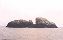
- BTW, Pub. 141 of the Sailing Directions (Enroute) is also the source of this little photo of Sule Stack. Small, but still gives a good impression of the nature of this tiny island.--Ratzer (talk) 19:51, 7 September 2009 (UTC)
- Thanks - that's very helpful. I couldn't see the 0.3km2 figure for Sula Sgeir in either tho' - could you tell me where that comes from? Ben MacDui 18:22, 8 September 2009 (UTC)
- The 0.3 km² area was found in the de-WP article de:Sula Sgeir. I took it from there, but did not attempt independent verification. However, there is an antique overview map with a scale bar (one English Mile). From there you can perhaps gauge and eyeball that 0.3 km² should not be far from the truth, although it might be less than 0.3 km² actually (about half a mile long, by one sixth or less of a mile average widht?).--Ratzer (talk) 20:03, 8 September 2009 (UTC)
- Well it is actually less, it is 0.2 km² or 20 hectares. This unverified area figure would not let me sleep anymore, so I searched Google high and low until I found a source, which would be The Flora of North Rona 1972. However, that is a PDF document available only against payment. But the one Google search result showed me in the hit that the area was "20 hectares". Do a Google search with "Sula Sgeir" "20 hectares" like here and it's the first of two hits, where you see it.--Ratzer (talk) 20:27, 8 September 2009 (UTC)
- You beat me to the draw - but which is the better source - and is it worth worrying about? You can also compare Sula Sgeir with Sule Skerry visually at grid reference HW621305 and grid reference HX620240. They look similar to me. Ben MacDui 20:37, 8 September 2009 (UTC)
- Thanks - that's very helpful. I couldn't see the 0.3km2 figure for Sula Sgeir in either tho' - could you tell me where that comes from? Ben MacDui 18:22, 8 September 2009 (UTC)

I believe it has stopped shrinking now. We have "discovered" an unsized tidal island - Eilean Mhic Chrion in Loch Criagnish at grid reference NM804035. It is somewhere in the 35 - 45 ha range. Would the Area tool be able to check this one out? Ben MacDui 20:06, 12 September 2009 (UTC)
- I just tried it but Wikimapia Geotools doesn't seem to work anymore. It had disappeared as a Wikimapia feature when the new beta version became official in July 2009, but could still be invoked with the Javascript javascript:loadjs('polynewa.js');loadjs('geotoolsa.js','if(is_addfn){cancelpoly();}mesarea();');jwindow3_menu(1); in the URL line. I just tried it now, but you can only mark areas, it doesn't show area results. I have to search more whether someone found a fix on that, or if someone wir Java knowledge can fix the script. Until then, the area of your island should be given with less precision, such as 0.5 km².--Ratzer (talk) 11:18, 13 September 2009 (UTC)
Can you?
In the page Ogasawara, Tokyo you appear to have made a Revision as of 04:46, 8 July 2009. You added text and a reference tag. That reference tag, <ref name="enkaku" /> appears to be causing a cite error. Could you please go back and fill out the full source to fix the cite error. Thanks. 75.69.0.58 (talk) 12:23, 14 September 2009 (UTC)
- Sorry, I had overlooked that wrong citation. The correct citation would have been http://www.vill.ogasawara.tokyo.jp/outline/history/history.htm, but I just found this link seems to be dead. I am looking where the information was moved to, and shall reference it in the Ogasawara article then.--Ratzer (talk) 10:18, 15 September 2009 (UTC)
- It's fixed now. The link is a Japanese only page. No, I don't speak Japanese, but I have a colleague on the de-WP who does.--Ratzer (talk) 11:43, 15 September 2009 (UTC)