Major intersections (Cancelled US 99 project) edit
| County | Location | mi [1][2] | km | Destinations [3][2][4][5] | Notes |
|---|---|---|---|---|---|
| Imperial | Calexico | 0.00 | 0.00 | Southern terminus; continued into Mexico as Fed. 5 | |
| Heber | Southern terminus of SR 111 | ||||
| El Centro | South end of concurrency with US 80 | ||||
| North end of concurrency with US 80 | |||||
| Brawley | Main Street (Legislative Route 146 east) | ||||
| | |||||
| Riverside | Oasis | Pierce Street (Legislative Route 203 north) | Southern terminus of LRN 203 | ||
| Valerie | Western terminus of SR 195 | ||||
| Indio | Southern end of concurrency with SR 111 | ||||
| Northern end of concurrency with US 60/US 70 | |||||
| Northern end of concurrency with SR 111 | |||||
| Eastern end of freeway | |||||
| | Western end of freeway | ||||
| Legislative Route 187 north – Morongo Valley | |||||
| Eastern end of freeway | |||||
| Northern terminus of SR 111 | |||||
| Cabazon | Western end of freeway | ||||
| Banning | Eastern end of freeway | ||||
| Ramsey Street | Freeway interchange; no eastbound exit or entrance; former US 60 / US 70 east US 99 north | ||||
| Hargrave Street | Freeway interchange | ||||
| 8th Street | Freeway interchange | ||||
| 22nd Street | Freeway interchange | ||||
| Sunset Avenue | Freeway interchange | ||||
| Highland Springs Avenue | Freeway interchange | ||||
| Beaumont | Pennsylvania Avenue | Freeway interchange; no eastbound exit or entrance | |||
| Beaumont Avenue | Freeway interchange | ||||
| Freeway interchange; western end of concurrency with US 60 | |||||
| Western end of freeway | |||||
| Calimesa | Eastern end of freeway | ||||
| San Bernardino | Redlands | Western end of freeway | |||
| Southern terminus of LRN 190 | |||||
| San Bernardino | Eastern end of freeway | ||||
| Southern terminus of I-15 | |||||
| Uplands | Euclid Avenue (Legislative Route 192) – Ontario, California | ||||
| Los Angeles | Pomona | Northern terminus of SR 71 | |||
1.000 mi = 1.609 km; 1.000 km = 0.621 mi
| |||||
U.S. Route 80 in Arizona edit
=Historic Route 80 edit
Highway Proposals edit
This is where I put forward my proposals for new highways or changes to highways in existence. Since this is purely fictional, it can never be posted in a Wikipedia article of any kind.
U.S. Route 97 in Alaska edit
U.S. Route 97 | ||||
|---|---|---|---|---|
| Alaska Highway Senator Ted Stevens Memorial Highway | ||||
| Route information | ||||
| Maintained by Alaska DOT&PF | ||||
| Major junctions | ||||
| West end | Construction Road in Nome | |||
Chena Hot Springs Road in Fox | ||||
| East end | YT 97 at AK/YT Border | |||
| Location | ||||
| Country | United States | |||
| State | Alaska | |||
| Highway system | ||||
| ||||

My Proposal edit
My proposal is based off an old idea to extend US 97 to Alaska on two separate occasions in history. Once between 1957 and 1958, and once between 1964 and 1968 where it came very close to happening (signs and maps were even manufactured). Although the AASHTO guidelines state that odd numbered highways are usually North/South, US 97 would be an exception to that rule. Due to the Alaska Highway's routing and AK-2's routing being mainly East/West, North/South would be confusing to apply to US 97. As for the naming portion, Alaska Highway would be applied as the main title for US 97 in Alaska due to the highway mainly following the route of the Alaska Highway. The secondary name would be after the late Senator Ted Stevens of Alaska. The tertiary name would not be Goat. YT 1 in Yukon would become YT 97 in accordance to BC 97 and US 97. Both BC 97 and YT 97 would then become a new link of the Trans-Canada Highway system.
Construction edit
Not much construction would be required east of the Dalton Highway. Every now and then, there may be sections that need to be upgraded to four lane divided trunk road status, specifically between the Dalton and Fairbanks, Alaska for major truck traffic. A new two lane highway completely paved would need to be built from the Dalton to Nome (which is currently being planned as an extension of AK-2). The only freeway sections would be in Fairbanks.
Route Location edit
US 97 in Alaska would follow the general route of AK 2 from the Yukon to its proposed extension west into Nome. In Nome, it would follow Front Street, West F Street, Seppala Drive, Center Creek Road and F.A.A. Road to its junction with Construction road at Nome Airport, where it would terminate. The reasoning for its location is to follow the entire path of AK-2 and to provide better tourism to Nome, which hosts part of the Iditarod Trail event every year. Doing this would make US 97 indisputably the northernmost U.S. Highway in existence.
U.S. Route 97 Alternate in Alaska edit
U.S. Route 97 | ||||
|---|---|---|---|---|
| Dalton Highway James W. Dalton Highway Dalton Extension Road | ||||
 | ||||
| Route information | ||||
| Maintained by Alaska DOT&PF | ||||
| Length | 414 mi (666 km) | |||
| Major junctions | ||||
| South end | ||||
| North end | East Lake Colleen Drive in Deadhorse | |||
| Location | ||||
| Country | United States | |||
| State | Alaska | |||
| Highway system | ||||
| ||||
My Proposal edit
AK-11 is by far one of the most important highways in the state of Alaska. It carries the Dalton Highway which provides truck service and maintenance service to the Trans-Alaska Pipeline.
Due to the heavy truck traffic that uses the archaic highway, it would make sense for it to become the Alternative route to US 97. Federal funding would improve the road to be truck friendly and less dangerous. Although this may bring an end to the popular show Ice Road Truckers, the benefits would outweigh the costs of this project. An alternate idea would be to make this the main trunk of US 97.
Unlike my proposed US 97, US 97 Alt. would be a North/South route due to its heading. If this where to become the main US 97, then US 97 would be designated North/South for its entire length in Alaska.
Construction edit
US 97 Alt. would require a lot of reconstruction. The mostly unimproved road would need to be reconstructed into a straighter four lane divided trunk road for much of its length. The Dalton would then become an all-weather highway leading to Prudhoe Bay.
Route Location edit
Not much needs to be said here. The main reasoning for why US 97 Alt. would use the Dalton is above. There may be a few sections where US 97 Alt. runs almost exactly parallel to the Trans-Alaska pipeline given the circumstances.
Other Proposals edit
U.S. Highways edit
U.S. Route 80 edit
- US 180 becomes the western extension of US 80. Even though US 180 travels north of US 60 and US 70 later on, it would be doing a similar action to US 30 and US 20. This would also place US 80 to end at the Grand Canyon. AZ 80 would have to be re-numbered along with NM 80 though. Doing this would eliminate bureaucratic nonsense in the system.
- US 380 becomes US 269 due to its connection with US 69 and disconnection from US 80.
U.S. Route 88 edit
- US 190 would be re-numbered US 88. US 88 makes more sense than US 190. A mainline U.S. Highway number should be a larger priority than a secondary number (US 395 and US 101 are exceptions to this).
U.S. Highway Shields 1926 edit
Note that the shields displayed below are meant to be a personal reference or something along those lines.
Primary U.S. Highways edit
First U.S. Highway Shield Ever Made edit

US 1 edit


US 2 edit


US 3 edit


US 4 edit


US 5 edit


US 6 edit


US 7 edit


US 8 edit


US 9 edit


US 10 edit


US 11 edit


US 12 edit


US 13 edit


US 14 edit


US 15 edit


US 16 edit


US 17 edit


US 18 edit


US 19 edit


US 20 edit


US 21 edit


US 22 edit


US 23 edit


US 24 edit


US 25 edit


US 26 edit


US 27 edit


US 28 edit

US 29 edit


US 30 edit


US 31 edit


US 32 edit


US 33 edit


US 34 edit


US 35 edit


US 36 edit


US 37 edit

US 38 edit


US 40 edit


US 41 edit


US 42 edit


US 43 edit


US 44 edit


US 45 edit


US 46 edit


US 48 edit

US 49 edit


US 50 edit


US 51 edit


US 52 edit


US 53 edit


US 54 edit


US 55 edit


US 58 edit


US 59 edit


US 60 edit


US 61 edit


US 62 edit


US 63 edit


US 64 edit


US 65 edit


US 66 edit


US 67 edit


US 68 edit


US 69 edit


US 70 edit


US 71 edit


US 72 edit


US 73 edit


US 74 edit

US 75 edit


US 76 edit


US 77 edit


US 78 edit


US 79 edit


US 80 edit


US 81 edit


US 82 edit


US 83 edit


US 84 edit


US 85 edit


US 87 edit


US 89 edit


US 90 edit


US 91 edit


US 92 edit

US 93 edit


US 94 edit

US 95 edit


US 96 edit

US 97 edit


US 98 edit

US 99 edit


US 101 edit


Secondary U.S. Highways edit
US 395 edit


US 410 edit


US 466 edit


US 666 edit


1927 Arizona State Route Shields edit


Arizona Map References edit
Arizona ADOT Resolution References edit
U.S. Route 80 in Texas edit
Major Intersections in 1956 edit
As per a 1956 Shell Oil Company Map of Texas.[14][15]
| County | Location | mi | km | Destinations | Notes |
|---|---|---|---|---|---|
| El Paso | Anthony | Texas–New Mexico state line | |||
| El Paso | Southern terminus of concurrency with US 85 | ||||
| Hudspeth | Sierra Blanca | ||||
| Culberson | Van Horn | Western terminus of US 90. | |||
| Kent | |||||
| Reeves | | Western terminus of US 290. | |||
| Pecos | |||||
| Ward | Pyote | ||||
| Monahans | |||||
| Crane | | No major intersections. | US 80 passed briefly through the northwetern tip of Crane County. | ||
| Ector | Odessa | ||||
| Midland | Midland | ||||
| Martin | Stanton | ||||
| Howard | Big Spring | ||||
| Mitchell | Colorado City | ||||
| Nolan | Roscoe | Western end of US 84 concurrency | |||
| Sweetwater | |||||
| Taylor | Abilene | Eastern end of US 84 concurrency | |||
| Callahan | Baird | ||||
| Eastland | Cisco | Eastern terminus of US 380. | |||
| Eastland | |||||
| Erath | Thurber | Western end of SH 108 concurrency | |||
| | Eastern end of SH 108 concurrency | ||||
| Palo Pinto | Eastern terminus of SH 193 | ||||
| Parker | Weatherford | ||||
| Western end of concurrency with US 180 | |||||
| Tarrant | Fort Worth | ||||
| Western end of US 377 concurrency | |||||
| East end of US 377 concurrency | |||||
| Eastern end of concurrency with US 180 and eastern terminus of US 180 | |||||
| Dallas | Arcadia Park | ||||
| Dallas | Western terminus of Loop 260 | ||||
| Western end of US 67/US 77 concurrency | |||||
| Eastern terminus of Loop 260 | |||||
| Eastern end of US 77 concurrency | |||||
| Western end of US 175 concurrency and northern terminus of US 175 | |||||
| Eastern end of US 175 concurrency | |||||
| Eastern end of US 67 concurrency | |||||
| Mesquite | |||||
| 1.000 mi = 1.609 km; 1.000 km = 0.621 mi | |||||
San Francisco and Portland Steamship Company edit
| Company type | Subsidiary of the Union Pacific Railroad |
|---|---|
| Industry | Shipping |
| Predecessor | Oregon Railroad and Navigation Company |
| Founded | 1904 |
| Fate | Defunct |
Area served | United States |
| Parent | Union Pacific Railroad |
Vessels edit
- SS Columbia (1880) (1904-1907) -
- SS George W. Elder (1904-1905) -
- SS Costa Rica (Dates unknown) -
- SS Barracouta (1906) - Temporary replacement for the Columbia chartered from the Pacific Mail Steamship Company
- SS Rose City ()
- SS Beaver (1910) ()
- SS Bear ()
Old Spanish Trail edit
Arizona section edit
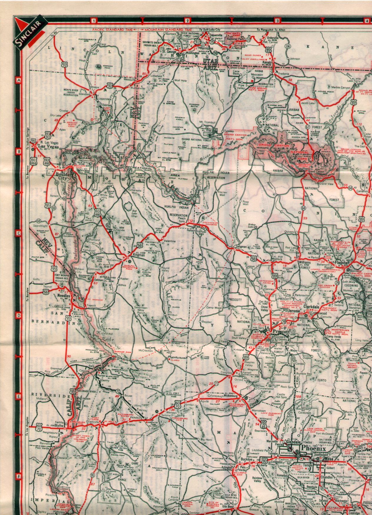
Through Arizona, the OST largely followed the route of the Bankhead Highway and Dixie Overland Highway.[17] Today, Interstate 8, Interstate 10 and sections of historic US 80 take this route.[18] The route of the OST was originally designated as the Ocean-to-Ocean Highway in 1911.[19]
The OST crossed into Arizona from California over the 1914 Ocean To Ocean Bridge. The bridge is still open to traffic today.[18] Between Yuma and Wellton, the OST travelled east along present day I-8 Business (old US 80) before taking a now non-existent roadway on the north side of the Southern Pacific Railroad tracks. The remnant of this highway is now called Araby Blaisdell Road. The OST then travelled northeast along present day US 95 and an abandoned section of highway to the west of US 95. The OST then curved east with railroad tracks over the old Butterfield Overland Stage Coach route to Dome before heading southeast to meet up with former US 80 again in Ligurta. The OST travelled east along old US 80 to Roll Road. Through Wellton, the OST took an older roadway along the north edge of the railroad tracks. This alignment was destroyed in a 1931 flood. Today, the main route takes Los Angeles Avenue through town.[18][20]
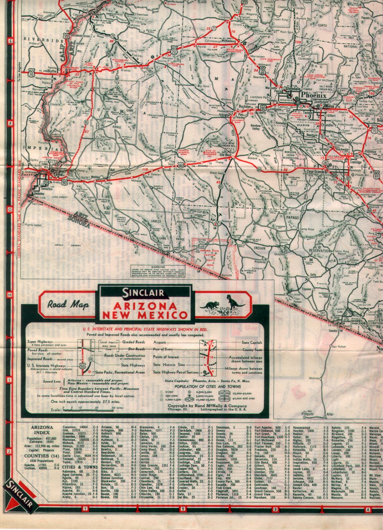
From 1919 to 1924, the OST travelled north on Roll Road across the Antelope Hill Bridge over the Gila River and followed Roll Road and Agua Caliente Road through Agua Caliente to Arlington. This route however was prone to damage by flooding, which was also often responsible for destroying the bridge on a constant basis.[19][21][18] Following two particularily devastating floods in 1919 and 1920, the Arizona Highway Department built a new state highway from Wellton through Dateland and Gila Bend to Arlington. Though the highway was opened in 1922, the OST wasn't rerouted onto it until 1925.[19][20] Thi alignment later became part of US 80, then I-8 and Arizona State Route 85.[18] From Arlington, the OST followed old US 80, now MC 85 and Buckeye Road, into Phoenix.[18][20]
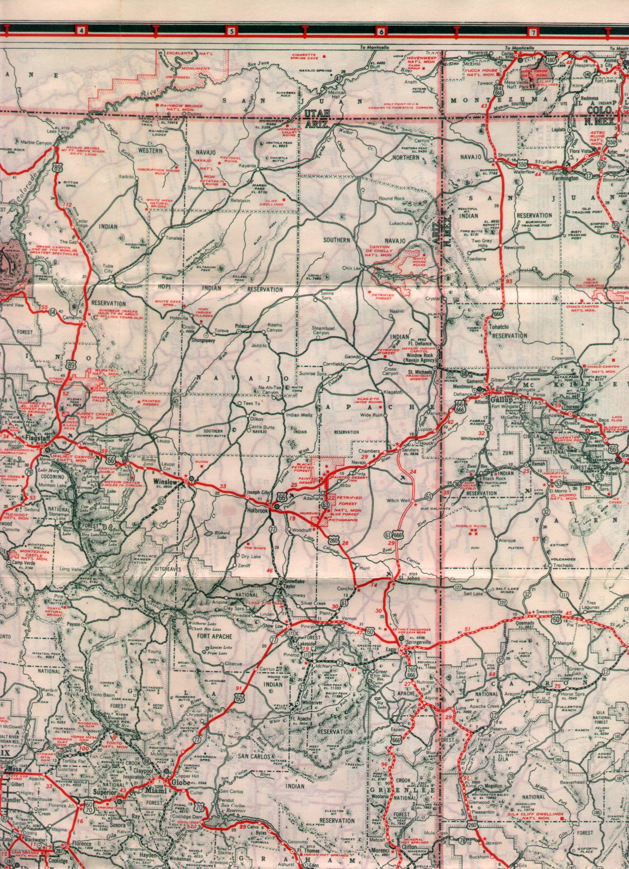
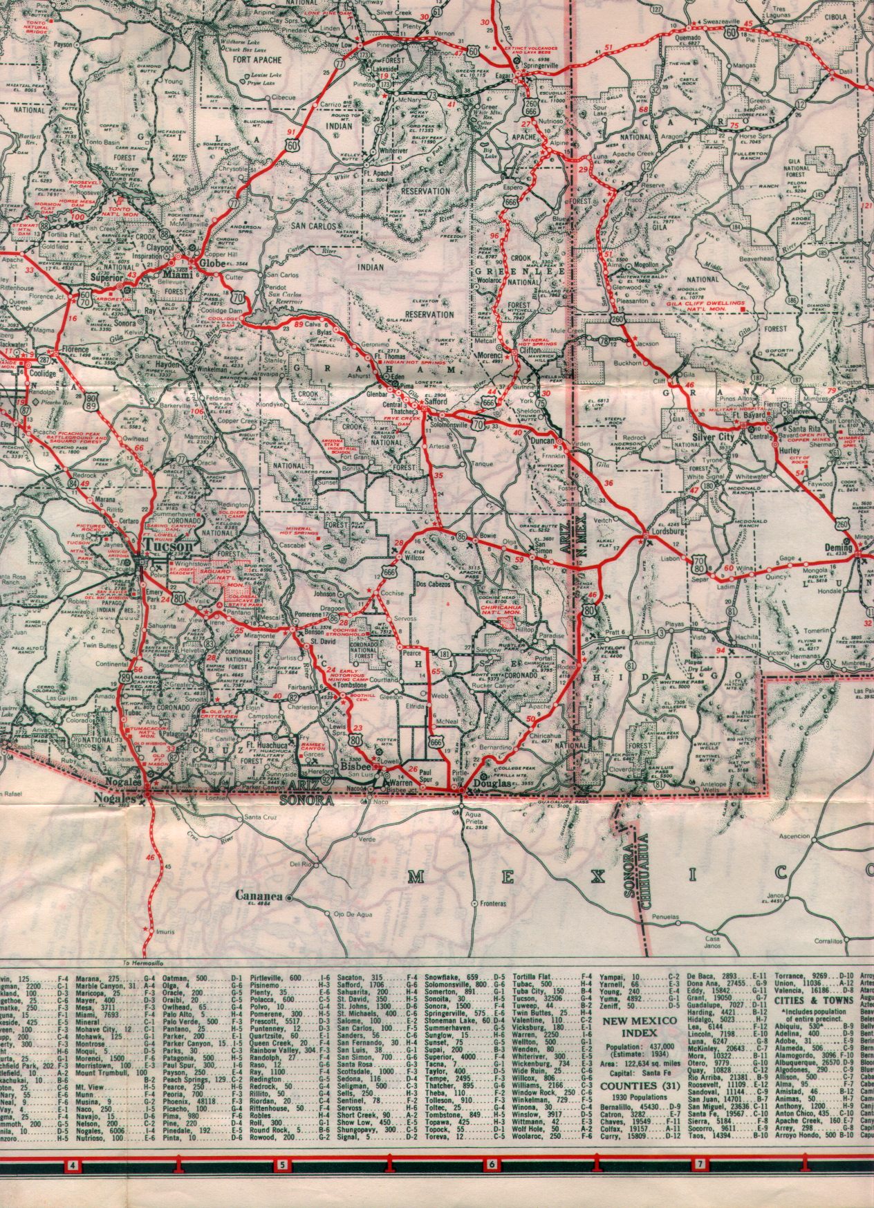
Before 1925, the OST routing split from old US 80 in Mesa and followed AZ 87 south to Chandler, then went east on Hunt Highway where it rejoined old US 80 (now AZ 79) just north of Florence.[18][21] Starting in 1925, OST followed the route of old US 80 (now US 60 and AZ 79) through Apache Junction and Florence Junction into Florence.[18][20]
The OST continued south from Florence through Oracle Junction and present day Oro Valley into Tucson over old US 80 (now AZ 79 and AZ 77).[20][18]
U.S. Route 91 | ||||
|---|---|---|---|---|
| Arrowhead Trail | ||||
| Route information | ||||
| Maintained by ASHD | ||||
| Existed | November 11, 1926–June 25, 1974 | |||
| History | Predecessor to I-15 | |||
| Location | ||||
| Country | United States | |||
| State | Arizona | |||
| Highway system | ||||
| ||||
| ||||
.svg)
November 11, 1926[22] September 9, 1927[23] June 25, 1974[24]
![]()
![]() US 66 east
US 66 east
| Number | Length (mi) | Length (km) | Southern or western terminus | Northern or eastern terminus | Formed | Removed | Notes | |
|---|---|---|---|---|---|---|---|---|
| — | — | — | — | — | — | |||
| — | — | — | — | — | — | |||
| — | — | — | — | — | — | |||
| — | — | — | — | — | — | |||
| — | — | — | — | — | — | |||
| — | — | — | — | — | — | |||
| — | — | — | — | — | — | |||
| — | — | — | — | — | — | |||
| — | — | — | — | — | — | |||
| — | — | — | — | — | — | |||
- ^ California Division of Highways (1963). Road Map of the State of California (Map). [1:158,400]. Sacramento: California Division of Highways.
- ^ a b Road Map of California (Map). Cartography by Tele Atlas. Google Inc. 2018. Retrieved 2018-10-28.
- ^ California Division of Highways (1963). Progress Map of the California Freeway and Expressway System (Map). [1:158,400]. Sacramento: California Division of Highways.
- ^ Warring, KS (November 7, 2008). "Interstate 5" (PDF). California Numbered Exit Uniform System. California Department of Transportation. Retrieved 2018-10-28.
- ^ Warring, KS (November 7, 2008). "Interstate 10" (PDF). California Numbered Exit Uniform System. California Department of Transportation. Retrieved 2018-10-28.
- ^ E.V. Miller (1926). Map of Arizona (Map). Arizona Highway Department. Retrieved May 6, 2015 – via AARoads.
- ^ W.B. Larls (1927). Arizona State Highway Commission Offical State Routes and State Highways of the State of Arizona (Map). Arizona Highway Department. Retrieved May 6, 2015 – via AARoads.
- ^ W.M. DeMerse (1935). Road Map of Arizona (Map). Arizona State Highway Department. Retrieved May 6, 2015 – via AARoads.
- ^ Road Map of Arizona and New Mexico (Map). Rand McNally. Retrieved May 6, 2015 – via 1938.
{{cite map}}: Unknown parameter|access=ignored (|access-date=suggested) (help) - ^ Road Map of Arizona and New Mexico (Map). Rand McNally. Retrieved May 6, 2015 – via 1938.
{{cite map}}: Unknown parameter|access=ignored (|access-date=suggested) (help) - ^ Road Map of Arizona and New Mexico (Map). Rand McNally. Retrieved May 6, 2015 – via 1938.
{{cite map}}: Unknown parameter|access=ignored (|access-date=suggested) (help) - ^ Road Map of Arizona and New Mexico (Map). Rand McNally. Retrieved May 6, 2015 – via 1938.
{{cite map}}: Unknown parameter|access=ignored (|access-date=suggested) (help) - ^ Staff. "ADOT Right-of-Way Resolution 1935-P-300". Arizona Department of Transportation. Retrieved May 6, 2015.
- ^ Shell Oil Company; H.M. Gousha Company (1956). Shell Highway Map of Texas (western portion) (Map). 1:1,647,360. Chicago: Shell Oil Company. Retrieved April 30, 2015 – via David Rumsey Map Collection.
- ^ Shell Oil Company; H.M. Gousha Company (1956). Shell Highway Map of Texas (eastern portion) (Map). 1:1,647,360. Chicago: Shell Oil Company. Retrieved April 30, 2015 – via David Rumsey Map Collection.
- ^ Official Road Map of New Mexico (PDF) (Map). 1:1,900,800. Annual Official State Highway Map. Cartography by Jorgensen. Santa Fe: New Mexico State Highway Department. 1935. Retrieved 2018-10-18.
- ^ Weingroff, Richard F. (October 17, 2013). "U.S. Route 80: The7 Dixie Overland Highway". Highway History. Federal Highway Administration. Retrieved April 1, 2015.
- ^ a b c d e f g h i Jensen, Jeff (2013). Drive the Broadway of America!. Tucson, Arizona: Bygone Byways. ISBN 9780978625900.
- ^ a b c Fraser, Clayton B. (July 2006). "Historic American Engineering Record: Gillespie Dam Bridge" (PDF): 14–16 – via National Park Service Santa Fe Support Office.
{{cite journal}}: Cite journal requires|journal=(help) - ^ a b c d e Rand McNally and Company (1925). Rand McNally Auto Trails Map of Arizona and New Mexico (Map). 1:1,393,920. Chicago: Rand McNally and Company. Retrieved August 24, 2018 – via David Rumsey Map Collection.
- ^ a b Rand McNally and Company (1924). Rand McNally Auto Trails Map of Arizona and New Mexico (Map). 1:2,290,000. Chicago: Rand McNally and Company. Retrieved April 1, 2015 – via David Rumsey Map Collection.
- ^ Bureau of Public Roads; American Association of State Highway Officials (November 11, 1926). United States System of Highways Adopted for Uniform Marking by the American Association of State Highway Officials (Map). 1:7,000,000. Washington, DC: United States Geological Survey. OCLC 32889555. Archived from the original on November 9, 2013. Retrieved August 23, 2016 – via University of North Texas Libraries.
{{cite map}}: Unknown parameter|deadurl=ignored (|url-status=suggested) (help); Unknown parameter|last-author-amp=ignored (|name-list-style=suggested) (help) - ^ "History of the Arizona State Highway Department" (PDF). June 1939. Retrieved July 27, 2019 – via Arizona Memory Project.
{{cite web}}: Cite uses deprecated parameter|authors=(help) - ^ U.S. Route Numbering Subcommittee (June 25, 1974). "U.S. Route Numbering Subcommittee Agenda" (Report). Washington, DC: American Association of State Highway and Transportation Officials. p. 2 – via Wikisource.