
Sendai, Tokyo, and Almaty stats along with the format are from Talk:List of metro systems#City summary for cities with multiple systems?
- ^ a b c 仙台市地下鉄 [Sendai Municipal Subway] (in Japanese). 一般社団法人 日本地下鉄協会 [Japan Subway Association]. 2017. Retrieved 2018-10-25.
- ^ "New subway line opens in disaster-hit Sendai". National. The Japan Times. Jiji Press Ltd. 6 December 2015. Archived from the original on 2015-12-06. Retrieved 2018-10-23.
- ^ a b c d 都営地下鉄 [Toei Subway] (in Japanese). 東京都交通局 [Tokyo Metropolitan Bureau of Transportation]. 1 April 2017. Retrieved 2018-10-25.
- ^ 路線図 [Network map] (in Japanese). 一般社団法人 日本地下鉄協会 [Japan Subway Association]. Retrieved 2018-10-25.
- ^ "Information on each station › Bakuro-yokoyama". 東京都交通局 [Tokyo Metropolitan Bureau of Transportation]. Retrieved 2018-10-25.
- ^ Hornyak, Tim (16 December 2017). "Heart of gold: The Ginza Line celebrates its 90th birthday". Japan Times. Retrieved 2018-10-07.
- ^ "Traffic Performance by Station". Tokyo Metro Co., Ltd. 31 March 2015. Retrieved 2018-10-07.
- ^ "Business Situation". Tokyo Metro Co., Ltd. 31 March 2015. Retrieved 2014-06-07.
- ^ http://www.tokyo-monorail.co.jp/company/profile.html
- ^ Note: combined ridership is the sum of the ridership of each system
- ^ a b c Kava, Alexander (20 April 2015). "Presidential opening for Almaty metro extension". International Railway Journal. Retrieved 2015-04-20.
- ^ Cite error: The named reference
france.fr2was invoked but never defined (see the help page). - ^ "RAPPORT D'ACTIVITÉ 2015" (PDF). STIF. p. 18. Retrieved 2017-03-17.
- ^ Cite error: The named reference
RATP-tramwas invoked but never defined (see the help page). - ^ Cite error: The named reference
T4-homewas invoked but never defined (see the help page). - ^ Cite error: The named reference
RATP-2014was invoked but never defined (see the help page).
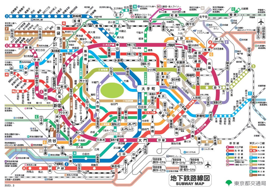
- ^ As of October 2018,[update] the number is 106 if the 7 interchange stations (i.e. different sets of platforms) are counted multiple times, once for each line, while it is 99 if they are combined; Higashi-nihombashi station and Bakuro-yokoyama station, where an out-of-system transfer between Asakusa Line and Shinjuku Line is possible, are anyway counted as two stations.[3][4][5]
- ^ 東京臨海高速鉄道㈱: 平成28年度決算の概要 (PDF). Retrieved 13 September 2017.