| [2]
|
Registered Historic Place name[3]
|
Image
|
Date listed[3]
|
Location
|
City or Town
|
Summary
|
| 1
|
Bryant H. and Lucie Barber House
|

|
1993-02-10
|
103 N. Barber Ave.
41°59′13″N 89°34′38″W / 41.98694°N 89.57722°W / 41.98694; -89.57722 (Barber, Bryant and Lucie, House)
|
Polo
|
The former home of Bryant H. and Lucie Barber.
|
| 2
|
Buffalo Grove Lime Kiln
|

|
2002-11-20
|
Galena Trail Rd.
41°59′13″N 89°34′38″W / 41.98694°N 89.57722°W / 41.98694; -89.57722 (Buffalo Grove Lime Kiln)
|
Polo
|
When in use, the kiln would have produced raw quicklime.
|
| 3
|
Buffalo Township Public Library
|
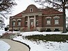
|
1995-11-07
|
302 W. Mason St.
41°59′13″N 89°34′38″W / 41.98694°N 89.57722°W / 41.98694; -89.57722 (Buffalo Township Public Library)
|
Polo
|
A Carnegie library.
|
| 4
|
Chana School
|

|
2005-12-06
|
201 N. River Rd.
42°00′47″N 89°19′59″W / 42.01306°N 89.33306°W / 42.01306; -89.33306 (Chana School)
|
Oregon
|
The school is an oddly shaped, two-room schoolhouse which has been moved from its original location.
|
| 5
|
Chicago, Burlington, and Quincy Railroad Depot
|

|
1997-07-25
|
400 Collins St
42°00′47″N 89°19′59″W / 42.01306°N 89.33306°W / 42.01306; -89.33306 (Chicago, Burlington, and Quincy Railroad Depot)
|
Oregon
|
The original train station built in Oregon.
|
| 6
|
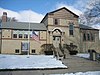
City and Town Hall
|

|
1992-08-18
|
Jct. of Fourth Ave. and Sixth St.
41°55′24″N 89°03′56″W / 41.92333°N 89.06556°W / 41.92333; -89.06556 (City and Town Hall)
|
Rochelle
|
The two-story Italianate structure features several decorative elements and an 1863 American Civil War cannon on its lawn.
|
| 7
|
Flagg Township Public Library
|
|
1973-10-25
|
NE corner 7th St. at 4th Ave.
41°55′24″N 89°03′56″W / 41.92333°N 89.06556°W / 41.92333; -89.06556 (Flagg Township Public Library)
|
Rochelle
|
A Carnegie library.
|
| 8
|
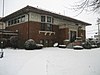
Henry D. Barber House
|

|
1992-08-18
|
410 W. Mason St.
41°59′13″N 89°34′38″W / 41.98694°N 89.57722°W / 41.98694; -89.57722 (Barber, Henry D., House)
|
Polo
|
|
| 9
|
John Deere House and Shop
|

|
1966-10-15
|
Illinois and Clinton Sts.
41°50′20″N 89°28′46″W / 41.83889°N 89.47944°W / 41.83889; -89.47944 (Deere, John, House and Shop)
|
Grand Detour
|
Former home of founder John Deere.
|
| 10
|
John McGrath House
|

|
1996-05-02
|
403 W. Mason St.
41°59′13″N 89°34′38″W / 41.98694°N 89.57722°W / 41.98694; -89.57722 (McGrath, John, House)
|
Polo
|
|
| 11
|
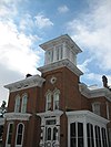
Ogle County Courthouse
|

|
1991-09-10
|
Courthouse Sq.
42°00′47″N 89°19′59″W / 42.01306°N 89.33306°W / 42.01306; -89.33306 (Ogle County Courthouse)
|
Oregon
|
County courthouse that was built in 1891.
|
| 12
|
Oregon Commercial Historic District
|

|
2006-08-16
|
Roughly bounded by Jefferson, Franklin, 5th and 3rd Sts.
42°00′47″N 89°19′59″W / 42.01306°N 89.33306°W / 42.01306; -89.33306 (Oregon Commercial Historic District)
|
Oregon
|
Shows Architectural styles of Italianate, Queen Anne, Romanesque Revival, Classical Revival, Art Deco, Arts and Crafts, Art Nouveau, Art Moderne, and Colonial Revival.
|
| 13
|
Oregon Public Library
|
|
2003-05-09
|
300 Jefferson St.
42°00′47″N 89°19′59″W / 42.01306°N 89.33306°W / 42.01306; -89.33306 (Oregon Public Library)
|
Oregon
|
A library constructed in 1909 through a grant by Andrew Carnegie.
|
| 14
|
Pinehill Inn
|
|
1978-07-24
|
400 Mix St.
42°00′47″N 89°19′59″W / 42.01306°N 89.33306°W / 42.01306; -89.33306 (Pinehill Inn)
|
Oregon
|
An example of Italianate architecture.
|
| 15
|
Polo Independent Order of Odd Fellows Lodge No. 197
|

|
2004-12-06
|
117 W. Mason St.
41°59′13″N 89°34′38″W / 41.98694°N 89.57722°W / 41.98694; -89.57722 (Polo Independent Order of Odd Fellows Lodge No. 197)
|
Polo
|
|
| 16
|
Samuel M. Hitt House
|

|
1985-11-14
|
7782 IL 64 W.
42°02′51″N 89°26′02″W / 42.04750°N 89.43389°W / 42.04750; -89.43389 (Hitt, Samuel M., House)
|
Mount Morris
|
|
| 17
|
Soldier's Monument
|

|
1985-02-14
|
Chestnut and 2nd Sts.
42°07′38″N 89°15′39″W / 42.12722°N 89.26083°W / 42.12722; -89.26083 (Soldier's Monument)
|
Byron
|
Was the first of its kind in northern Illinois.
|
| 18
|
Stillman's Run Battle Site
|

|
1983-12-08
|
Roosevelt and Spruce Sts.
42°06′21″N 89°10′48″W / 42.10583°N 89.18000°W / 42.10583; -89.18000 (Stillman's Run Battle Site)
|
Stillman Valley
|
The site of Battle of Stillman's Run.
|
| 19
|
White Pines State Park Lodge and Cabins
|
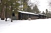
|
1985-03-04
|
RR #1
42°02′51″N 89°26′02″W / 42.04750°N 89.43389°W / 42.04750; -89.43389 (White Pines State Park Lodge and Cabins)
|
Mount Morris
|
|
| 20
|
William H. Holcomb House
|

|
1973-10-25
|
526 N. 7th St.
41°55′24″N 89°03′56″W / 41.92333°N 89.06556°W / 41.92333; -89.06556 (Holcomb, William H., House)
|
Rochelle
|
An example of an Italianate structure.
|
| 21
|
William Moats Farm
|

|
1987-02-12
|
Wood Rd.
42°07′38″N 89°15′39″W / 42.12722°N 89.26083°W / 42.12722; -89.26083 (William Moats Farm)
|
Near Ashton
|
Former home of William Moats.
|


