The following table lists records of extreme temperature in territories of Africa. The elevation in metres above sea level of locations reporting record minimum temperatures is given where relevant.
^†ʘ Record observed in an area with a permanent resident population. Unless otherwise stated, this will be the case.
^†O Territory or location has no permanent resident population.
^†50 Record in the last 50 years; only given if the all-time record occurred more than 50 years ago.
Notes and References edit
- ^ Bulletin Mensuel 1945, Algérie du Nord, Institut de Météorologie et de Physique du Globe de l’Algérie, NOAA Central Library, Climate Data Imaging Project (in French; Monthly Bulletin, 1945). Retrieved 24 January 2007.
- ^ a b c d e f g h i j k l m n o p q r s Form to get daily summaries from synop reports, OGIMet. Retrieved 6 January 2024.
- ^ Temperatures as high as 57°C have been reported at various places in Algeria including Tindūf, Timimūn, Warqlā (Ouargla) and Tūjurt (Touggourt) before 1950 but none are reliable.
- ^ WMO Normals 1991-2020, Mecheria (Station 60549), NOAA. Retrieved 17 December 2023.
- ^ a b c d e f g h i j k l m n o p q r s t u v w x y z aa ab Global Surface Summary of the Day (GSOD), National Oceanic and Atmospheric Administration (NOAA). Retrieved 1 January 2024.
- ^ a b -4.1°C was reported at a station (elevation 1245 m) in the generally uninhabited Bicuari National Park on 21 July 2016. Temperatures as low as -8°C reported at various place in Angola between the late 1930’s and early 1950’s are unreliable, probably due to instrument overexposure.
- ^ a b c d Weather stations in Angola, Botswana, Namibia, South Africa and Zambia, SASSCAL WeatherNet. Retrieved 8 August 2021.
- ^ Higher temperatures reported at various place in Angola between the late 1930’s and early 1950’s are unreliable, probably due to instrument overexposure.
- ^ a b c d e f g h i j k l m n o p q r s t u v w x y z aa ab ac ad ae af ag ah ai aj ak Climate Explorer, The Royal Netherlands Meteorological Institute (KNMI). Retrieved 3 January 2022.
- ^ 46.0°C reported at Kandi in April 1940, and 44.9°C reported at Natitingou in March 1934 are unreliable. 44.5°C reported at Kandi in April 1952 is possibly reliable.
- ^ Report for the Year 1953, Weather Bureau, Department of Transport, Republic of South Africa, NOAA Central Library, Climate Data Imaging Project. Retrieved 8 March 2008.
- ^ -15.2°C reported at the same place (in August between 1959 and 1980) is probably a ground temperature, not an air temperature.
- ^ The island is uninhabited.
- ^ 14°C reported in March 1980 was taken at ground level.
- ^ Programme d’Action National d’Adaptation à la Variabilité et aux Changements Climatiques (PANA du Burkina Faso), Ministère de l’Environnement et du Cadre de Vie, Burkina Faso (in French; National Action Program for Adaptation to Variability and to Climate Change). Retrieved 3 January 2022.
- ^ 2.9°C reported at Banankélédara (Banankélédaga) (near Bobo-Dioulasso) on 29 January 1961, and 5.0°C reported at the same place in 1971 are probably unreliable.
- ^ Higher temperatures recorded before the 1940’s, including 48.4°C at Dori, 48.0°C at Ouahigouya and 47.9°C reported at both Fada N’gourma and Ouagadougou are unreliable.
- ^ Présentation du Bulletin climatologique annuel du Congo belge et du Ruanda-Urundi (1956) — Anomalies pluviométriques et valeurs remarquables de quelques éléments du climat, in: Bulletin des Séances, Academie Royale des Sciences Coloniales, 1957, 6, pp1214-1230, Royal Academy for Overseas Sciences, Belgium (in French; Presentation of the annual climatological bulletin of the Belgian Congo and Ruanda-Urundi (1956) - Pluviometric anomalies and remarkable values of some elements of the climate). Retrieved 1 March 2021.
- ^ Recorded at the Kisozi-Marais meteorological station, now closed.
- ^ a b Simone di Prima (climateofburundi.altervista.org)
- ^ La France équatoriale africaine: Le pays. Les habitants. La colonisation. Les pouvoirs publics, Google Books Search Engine. Retrieved 3 January 2022.
- ^ a b Ngaoundéré may have recorded 3.2°C in February between 1961 and 1990. -2.7°C has been recorded at high altitude on the summit of Fako Peak, Mount Cameroon at an elevation exceeding 4000 m.
- ^ a b c d Annales des Services Météorologiques de la France d’Outre-Mer, Année 1951, Ministère la France d’Outre-Mer, NOAA Central Library, Climate Data Imaging Project (in French; Annals of the Meteorological Services of Overseas France for 1951). Retrieved 5 February 2006.
- ^ 47.7°C reported at Kousséri Far North region on 18 April 1908 and 46.2°C reported at the same place in the previous month are sourced from a very limited record of less than a year and are of uncertain reliability.
- ^ a b Climate Atlas of the Archipelagos of the Canary Islands, Madeira and the Azores, Instituto Português do Mar e da Atmosfera (IPMA). Retrieved 17 September 2023.
- ^ -21.0°C was recorded at an altitude of about 2100 m at Cañada de la Grieta on Pico del Teide Tenerife in 1912. More recently, -16.0°C was recorded at Las Cañadas on the same mountain on 17 February 1991.
- ^ Evolución de la Temperatura en Lanzarote (1950-2008), Centro de Datos, Lanzarote (in Spanish; Evolution of the Temperature in Lanzarote (1950-2008)). Retrieved 3 January 2022.
- ^ This reading is possibly unreliable.
- ^ a b The official maximum temperature of 47.5°C reported at Barranco de Masca Tenerife on 17 July 1978 was taken at a station with a short period of record and is possibly unreliable.
- ^ Anais Meteorológicos das Colónias, Relativos a 1943, Ministérios das Colónias, Serviço Meteorológico Nacional, Portugal, NOAA Central Library, Climate Data Imaging Project (in Portuguese, Meteorological Annals of the Colonies Relating to 1943). Retrieved 4 February 2007.
- ^ Temperatures at Bangaeira in the Chã das Caldeiras (elevation 1670 m) on Fogo are reported to fall below 0°C in the winter months (January to March).
- ^ Temperatures up to 38°C reported at Praia are possibly reliable.
- ^ Climate: Bangaeira, Climate-Data.org. Retrieved 16 September 2022. Archived 6 January 2014.
- ^ This is the average monthly minimum temperature between January and March.
- ^ a b c Global Climate Data, TuTiempo.net. Retrieved 25 May 2018.
- ^ a b Valores Extremos, Agencia Estatal de Meteorología (AEMet) (in Spanish; Extreme Values). Retrieved 3 January 2022.
- ^ Anti-Locust Bulletin, Issues 11-21 - Page 16, Google Books Search Engine. Retrieved 31 March 2019.
- ^ Temperatures are known to reach -10°C on the high plateaux of the Tibesti Mountains. -6.8°C was recorded at an altitude of 2450 m on the uninhabited Doon Orei (Trou au Natron) dormant volcano in the same range on 15 January 1967. The lowest fully dated temperature is -4.5°C recorded at Bardāy (Bardaï) (elevation 1060 m) in the same region on 27 December 1966 and 27 January 1967.
- ^ Data Calendar for Faya-largeau, Iowa Environmental Mesonet, Iowa State University. Retrieved 28 October 2023.
- ^ Higher temperatures reported at Faya and Ndjamena (Nijāmīnā) are unreliable.
- ^ a b c d e METEOPROG.com, METEOPROG.com. Retrieved 15 January 2023.
- ^ a b c d e The reference has interpolated the value from the conditions prevailing at the time.
- ^ The lowest recorded temperature is 2.5°C at Faya-Largeau (Faya) Birku (Borkou) region on 25 January 2008.
- ^ Infrastructure, Eau, Environnement. Etude d'impact sur l'Environnement, The World Bank (in French; Infrastructure, Water, Environment. Environmental Impact Assessment). Retrieved 9 January 2022.
- ^ a b c d e f g h i j k MeteoManz, MeteoManz.com. Retrieved 28 December 2023.
- ^ Présentation du Bulletin climatologique annuel du Congo belge et du Ruanda-Urundi (1955) — Anomalies pluviométriques et valeurs remarquables de quelques éléments du climat, "in:" Bulletin des Séances, Academie Royale des Sciences Coloniales, 1956, 6, pp1231-1248, Royal Academy for Overseas Sciences, Belgium (in French; Presentation of the annual climatological bulletin of the Belgian Congo and Ruanda-Urundi (1955) - Pluviometric anomalies and remarkable values of some elements of the climate). Retrieved 1 March 2021.
- ^ Recorded at the Kisanga-Verger (Keyberg) meteorological station, now closed.
- ^ a b Vandenplas, A (1947). La Température au Congo Belge [The temperature in the Belgian Congo] (in French). Brussels, Belgium: Ministère des Colonies, Direction de l'Agriculture.
- ^ 41.0°C reported at Yahila Tshopo province in March between 1931 and 1936 is unreliable.
- ^ 41.0°C reported at Ouésso in March 1950 and April 1950 is unreliable.
- ^ 49.5°C reported at the same place in July 1934 and at Tajūrah (Tadjourah) in July 1951 are probably unreliable.
- ^ The first of these dates has also been reported as 46.5°C.
- ^ The lowest temperatures in Egypt are recorded in the Sinai Peninsula which is geographically part of Asia, not Africa. For instance, -8.8°C was reported at Qal̒at an-Nakhl (Nakhl) Shamal Sinā̓ (Northern Sinai) governorate on 16 January 2008, and -15°C was recorded at 2600 m on the uninhabited Jabal Zubayr, a spur of Jabal Katrīnah (Mount Catherine) Janub Sinā’ (Southern Sinai) governorate on approximately 13 January and 16 February 1934.
- ^ Monthly Weather Report 1961, Ministry of War Meteorological Department, Egypt, NOAA Central Library, Climate Data Imaging Project. Retrieved 8 May 2008.
- ^ 51.0°C on 4 July 1918, and 50.6°C on 8 June 1932, both reported at Aswān Aswān governorate are unreliable due to the thermometers (at a height of 1.3 m) being placed too close to the ground.
- ^ Isla de Bioko, La Web Cultural de Guinea Ecuatorial (in Spanish; Island of Bioko). Retrieved 3 January 2022.
- ^ Klimatafel von Bata / Insel Mbini / Äquatorial-Guinea, Deutscher Wetterdienst (in German: Climate Table for Bata /Mbini Island / Equatorial Guinea. Retrieved 27 May 2019.
- ^ a b 36.5°C reported at Malabo Bioko on 21 April 2010 is probably unreliable.
- ^ 49.1°C reported at Nokra Nokra Desēt island in the Dehalak’ (Dahlak) archipelago in September 1938 is unreliable.
- ^ Report for the Year 1957, Weather Bureau, Department of Transport, Republic of South Africa, NOAA Central Library, Climate Data Imaging Project. Retrieved 7 March 2008.
- ^ -6.7°C reported at Big Bend is unreliable for the elevation of 155 m.
- ^ Groundwater Resources of Swaziland (Government of Swaziland, Department of Geological Surveys and Mines), British Geological Survey. Retrieved 3 January 2022. Archived 23 October 2016.
- ^ 49.1°C reported at Siteki between 1921 and 1958 is unreliable.
- ^ Report on Meteorological Data of the Year 1976, Department of Transport, Republic of South Africa, NOAA Central Library, Climate Data Imaging Project. Retrieved 4 June 2018.
- ^ 2013 Annual Bulletin, National Meteorology Agency. Retrieved 3 January 2022. Archived 4 March 2016.
- ^ Also on earlier dates at the same place. -8.0°C reported at Jīma (Jimma) Oromia region is probably unreliable. -15°C has been reported at high altitude on the Sanetti Plateau in the Oromia region.
- ^ Pedgley, DE (1967). "Air Temperature at Dallol, Ethiopia". Meteorological Magazine. 97. Met Office: 265–271.
- ^ Annual Climate Bulletin for the Year 2019, National Meteorological Agency, Ethiopia. Retrieved 13 February 2021.
- ^ Data excludes territory below 60°S as defined by the Antarctic Treaty, thus excludes Adélie Land on the Antarctic mainland.
- ^ a b c Port aux Français, European Polar Board. Retrieved 7 August 2023.
- ^ a b Ile Juan De Nova - Station La Goulette, InfoClimat (in French). Retrieved 22 January 2023.
- ^ St-Paul & Amsterdam Islands, Part 3, Discover France! Retrieved 3 January 2022.
- ^ The date is believed to be correct.
- ^ a b Estimated. No data are known to exist.
- ^ Climatologie de l'année 2006 à Île de la Possession - Alfred Faure, Infoclimat (in French; Climatology of Possession Island (Alfred-Faure), 2006). Retrieved 3 January 2022.
- ^ Climatologie de l'année 1997 à Île de la Possession - Alfred Faure, Infoclimat (in French; Climatology of Possession Island (Alfred-Faure), 1997). Retrieved 3 January 2022.
- ^ Climatologie de l'année 1984 à Ile Europa, InfoClimat (in French; Climatology of Europa Island, 1984). Retrieved 3 January 2022.
- ^ Climatologie de l'année 1985 à Ile Europa, InfoClimat (in French; Climatology of Europa Island, 1985). Retrieved 3 January 2022.
- ^ Lower temperatures reported from the island do not appear reliable.
- ^ 35.8°C was possibly recorded on 29 January 1981 at the same place.
- ^ An unconfirmed 15.0°C (date unknown) has been reported from the island.
- ^ Climatologie de l'année 2001 à Iles Glorieuses, Station Gérard Martin, Infoclimat (in French; Climatology of the Glorioso Islands, Station Gérard Martin, 2001). Retrieved 8 January 2022.
- ^ Climatologie de l'année 2013 à Iles Glorieuses, Station Gérard Martin, Infoclimat (in French; Climatology of the Glorioso Islands, Station Station Gérard Martin, 2013). Retrieved 8 January 2022.
- ^ Climatologie de l'année 2011 à Ile Juan De Nova, InfoClimat (in French; Climatology of Juan de Nova Island, 2011). Retrieved 3 January 2022.
- ^ Temperatures as low as 17.6°C have been reported but none appear reliable.
- ^ Fiche Climatologique: Tromelin (984), Meteo France (in French; Climatological Data: Tromelin (984)). Retrieved 3 January 2022.
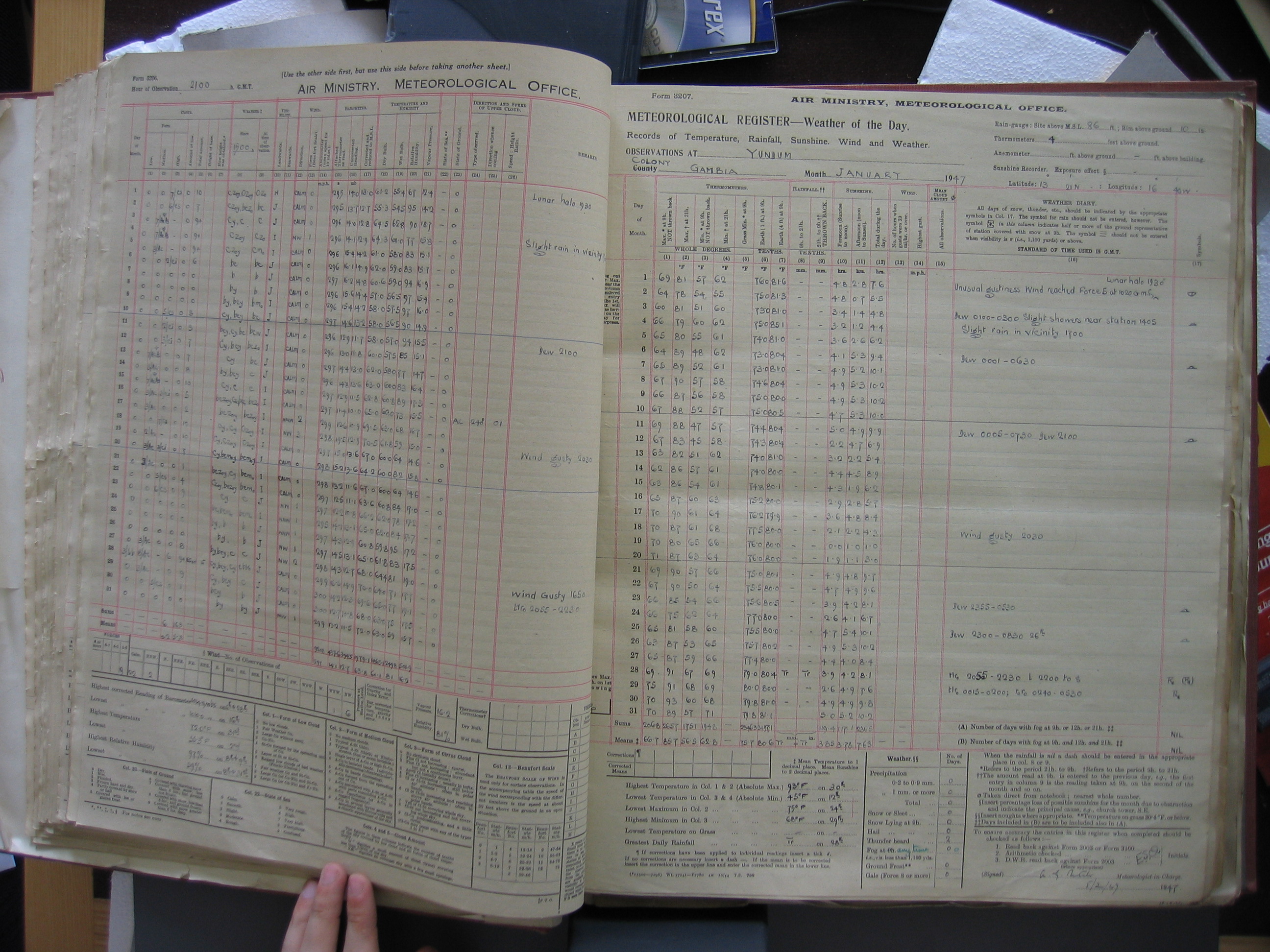
- ^ Meteorological Register. Weather of the Day, Yundum, Gambia. January 1947. Air Ministry, Meteorological Office, Centre for Environmental Data Analysis (CEDA). Retrieved 28 April 2021.
- ^ Unconfirmed temperatures below 5°C have been reported at inland stations.
- ^ Max Temp (oC), Danmarks Tekniske Universitet, Risø. Retrieved 20 June 2014. [dead link].
- ^ Ghana Year Book, 1963, Google Books. Retrieved 23 January 2023.
- ^ WMO Normals 1991-2020, Navrongo (Station 65401), NOAA. Retrieved 17 December 2023.
- ^ 45.0°C reported on 8 April 2021 at Navrongo is probably unreliable. 44.2°C reported on 17 April 2006 at Navrongo is probably reliable.
- ^ The date (19th) is believed to be correct.
- ^ WMO Normals 1991-2020, Bole (Station 65416), NOAA. Retrieved 17 December 2023.
- ^ Record cold snap destroys crops, kills hundreds of animals, The New Humanitarian. Retrieved 11 March 2021.
- ^ 46.5°C reported at Boké on 8 March 1938 is probably unreliable.
- ^ Resultado das observações meteorológicas, 1961, Serviço Meteorológico da Guiné, NOAA Central Library, Climate Data Imaging Project (in Portuguese; Results of meteorological observations, 1961). Retrieved 23 February 2007.
- ^ Resultado das observações meteorológicas, Março de 1969, Serviço Meteorológico da Guiné, NOAA Central Library, Climate Data Imaging Project (in Portuguese; Results of meteorological observations, March 1969). Retrieved 23 February 2007.
- ^ Heard Island The Spit, Relevés du 01 Mars 2013, Infoclimat (in French; Records of 1 March 2013). Retrieved 4 January 2022.
- ^ Google Search Engine, Google. (Kenya, A Study in Physical and Human Geography, by Francis F. Ojany and R. B. Ogendo.) Retrieved 4 June 2018.
- ^ -13°C has been recorded at 4200 m in the Teleki Valley on the upper slopes of Kirinyaga (Mount Kenya), and as low as -20°C has been reported near the summit (elevation close to 5200 m).
- ^ Climate and Soils of the South Kinangop Plateau of Kenya. Their limitations on land use., Wageningen University and Research eDepot]. Retrieved 7 January 2024.
- ^ Quaternary Periglacial Landforms in the Sani Pass Area, Southern Africa. South African Association of Geomorphologists, Uppsala Universitet. Retrieved 9 January 2022. Archived 7 February 2012.
- ^ This reading has also been reported as -21°C.
- ^ Report on Meteorological Data of the Year 1973, Weather Bureau, South Africa, NOAA Central Library, Climate Data Imaging Project. Retrieved 12 February 2012.
- ^ 41.7°C reported at Butha-Buthe in January 1927, and 40.6°C reported at Hlotse (Leribe) in December 1944 are unreliable.
- ^ Report on Meteorological Data of the Year 1975, Department of Transport, Republic of South Africa, NOAA Central Library, Climate Data Imaging Project. Retrieved 4 June 2018.
- ^ a b General Report on National Forest Inventory in Liberia - Technical Report No. 1. German Forestry Mission to Liberia, 1968, Food and Agriculture Organization of the United Nations (FAO). Retrieved 9 June 2018.
- ^ 2.2°C reported at Sagleipie in the 1950’s is of questionable reliability. 3.9°C reported at Kesini before 1964 is possibly reliable.
- ^ a b Cite error: The named reference
LIB2was invoked but never defined (see the help page). - ^ Temperatures exceeding 41°C reported at Tubmanburg (Bomi) have not been confirmed. 40.6°C reported at Sikombe, inland from Greenville in the early 20th century, and also from Sagleipie in the 1950’s are of questionable reliability.
- ^ "Liberia" Google Search Engine, Google. (Quarterly Statistical Bulletin of Liberia). Retrieved 9 January 2022.
- ^ a b Western Range DSO Iron Ore Project Volume 3, Part 2.1: Hydrology Baseline Final Report, ArcelorMittal Liberia Limited. Retrieved 7 May 2019.
- ^ a b No relevant measured data has been found. The value given is an estimate modelled by the United Kingdom Met Office based on data from Nzérékoré Guinea, 40km to the north of Tokadeh.
- ^ The same modelling estimates minimum temperatures of 6.1°C are reached around 1000m on the peaks in the north of the country.
- ^ McWhirter, Norris and Ross McWhirter (1969). Dunlop Illustrated Encyclopedia of Facts. Doubleday. ISBN 0385011199.
- ^ -11°C reported in January 1945 has not been confirmed.
- ^ WMO Normals 1991-2020, Zuara (Station 62007), WMO. NOAA. Retrieved 21 December 2023.
- ^ Libyan Meteorological Service
- ^ Higher temperatures reported are unreliable. 58.0°C reported at al-‘Azīzīyah on 13 September 1922 is a faulty reading and has been rejected by the World Meteorological Organization.
- ^ Résumé Mensuel du Temps à Madagascar, 1963, Météorologie Nationale, NOAA Central Library, Climate Data Imaging Project (in French; Monthly Summary of the Weather of Madagascar, 1963). Retrieved 24 February 2007.
- ^ Résumé Mensuel du Temps à Madagascar, 1964, Météorologie Nationale, NOAA Central Library, Climate Data Imaging Project (in French; Monthly Summary of the Weather of Madagascar, 1964). Retrieved 24 February 2007.
- ^ -16°C was recorded in the uninhabited La Cuvette du Boby at an elevation of 2470 m on the Andringitra Massif Haute Matsiatra region on 1 July 1956. -8.6°C reported at Antsirabe Vakinankaratra region in August 1915 is unreliable.
- ^ Communication Nationale Initiale de Madagascar, United Nations Framework Convention on Climate Change (in French; First National Communication of Madagascar). Retrieved 9 January 2022.
- ^ Higher temperatures (up to 48.3°C), especially those recorded in the 1930’s and 1940’s are probably unreliable.
- ^ Estudo Fitogeográfico dos Jardins, Parques e Quintas do Concelho do Funchal, Universidade de Lisboa (in Portuguese; Phytogeographic Study of the Gardens, Parks and Farms of the Municipality of Funchal). Retrieved 18 September 2023.
- ^ -9.5°C was recorded at an elevation of 1560m on the uninhabited mountain peak Bica da Cana Madeira Island on 5 March 1993.
- ^ Extremos climatológicos Portugal, Instituto Português do Mar e da Atmosfera (IPMA) (in Portuguese; Climatological Extremes Portugal). Retrieved 17 September 2023.
- ^ Orchids of Malaŵi, Google Books Search Engine. Retrieved 19 May 2019.
- ^ a b c A Summary and Review of Monthly Temperature Data in Malaŵi, Ministry of Agriculture and Natural Resources, Department of Agricultural Development, Lilongwe, ISRIC World Soil Information Database. Retrieved 18 October 2011. [dead link].
- ^ Reported as -7°C by the second reference.
- ^ a b Higher temperatures reported at Nkombedzi wa Fodya (near Chawuwa) Chikwawa district are unreliable.
- ^ Hot temperature over – Met., The Times Group, Malawi. Retrieved 30 January 2020. Archived 18 November 2019.
- ^ Mali météo, Météo Mali (in French; Mali meteo[rology]). Retrieved 10 January 2022. Archived 29 September 2008.
- ^ Higher temperatures, including 54.5°C at Tombouctou (Timbuktu) and 54.4°C at Arawan (Araouane), both in the Tombouctou (Timbuktu) region, and 52.0°C at Ménaka in the Gao region on 4 May 1934 are unreliable. 48.8°C reported at Nioro du Sahel Kayes region in May 1936, and at Timbuktu on 14 May 2011 are also unreliable.
- ^ 0.0°C reported at the same place on 16 December 1962 is probably unreliable.
- ^ Service de Météorologie (Mauritania)
- ^ Mauritius Meteorological Services.
- ^ Initial National Communication of the Republic of Mauritius under the United Nations Framework Convention on Climate Change (April 1999). Chapter 1, National Circumstances, Government of Mauritius. Retrieved 12 August 2021.
- ^ Monthly Bulletin of Climatological Summaries, January 2009, Mauritius Meteorological Services. Retrieved 10 January 2022. Archived 5 March 2016.
- ^ 38°C reported at Port Louis in January 1957, and 37.5°C reported at the same place on 7 February 1975 are probably unreliable.
- ^ 36.1°C reported three times on Île Raphael in February 1946 is probably unreliable.
- ^ a b Etienne Kapikian, MeteoFrance.
- ^ a b El Tiempo en la Provincia de Melilla Mañana, tiemposol.com (in Spanish; The Weather in the Province of Melilla Tomorrow). Retrieved 20 January 2022.
- ^ An unconfirmed -0.5°C has been reported, date unknown.
- ^ Relevé climatologique du mois de février 1935, Bulletin Officiel, Protectorat de la République Française au Maroc, 29 Mars 1935 No. 1170, Secrétariat Général du Gouvernement, Royaume du Maroc (in French; Climatological Record for February 1935. Retrieved 13 December 2023.
- ^ The details given are believed to be correct although the digitisation of the original reference is not completely clear. The same reference also reports -24.5°C at Būzmū (Bou Zemou) Mīdelt province (elevation 2350 m) on 1 February 1935.
- ^ -33.4°C reported at Tashdīrt (Tacheddirt)| al-Ḥawz (Al Haouz) province (elevation 2330 m) on 11 December 1934 is incorrect. -30°C reported in the Michlifen Depression Īfrān (Ifrane) province, elevation 1980 m sometime before 1964 has not been confirmed.
- ^ a b Vague de chaleur: de nouveaux records de température maximale au Maroc, Le Matin (in French; Heat wave: New maximum temperature records in Morocco). Retrieved 24 November 2023.
- ^ 51.8°C reported at Inezgane Airport in the same prefecture on 17 August 1940 is unreliable.
- ^ WMO Normals 1991-2020, Ifrane (Station 60160), NOAA. Retrieved 17 December 2023.
- ^ -17.5°C was reported at an uninhabited location (elevation 3650 m) near the summit of Jbel Mgun (Jebel M’Goun) Tanghir (Tinghir) province on 9 November 2001.
- ^ a b Boletim mensal das observações meteorológicas feitas nos postos da Colónia, 1950, Organizado Pelo Observatório Campos Rodrigues, NOAA Central Library, Climate Data Imaging Project (in Portuguese; Monthly bulletin of the meteorological observations made at colonial stations, 1950). Retrieved 6 September 2015.
- ^ 47.3°C reported at Chibuto Gaza province on 12 December 1944 is probably unreliable, being too high compared to nearby readings on this day. Temperatures as high as 49°C reported at various places between 1940 and 1955 are believed to be unreliable.
- ^ Report on Meteorological Data of the Year 1974, Department of Transport, Republic of South Africa, NOAA Central Library, Climate Data Imaging Project. Retrieved 4 June 2018.
- ^ Namibia Review Volume 1, Google Books Search Engine. Retrieved 9 June 2018.
- ^ 47.8°C reported from Noordoewer was probably an estimate taken from an actual reading observed at Goodhouse (South Africa) on 20 January 1939. The highest fully dated record known is 46.2°C at Noordoewer on 17 January 2013.
- ^ -3.0°C reported at Bilma in January 1937 is unreliable.
- ^ 49.5°C reported at Diffa on 7 September 1978 is unreliable.
- ^ WMO Normals 1961-1990, Jos (Station 65134), NOAA. Retrieved 21 December 2023.
- ^ 47.2°C reported at both Sokoto and Hadejia Jigawa state, as well as higher temperatures reported early in the 20th century are believed to be unreliable. More recently, 47.5°C on 5 June 2009 and 46.6°C on 9 March 2010, both at Nguru Yobe state, and 47.3°C at Gusau Zamfara state on 1 April 2007 are all believed to be unreliable.
- ^ a b La Réunion, Météo et climat, Météo-France (in French; Reunion Island, Meteorology and climate). Retrieved 10 January 2022.
- ^ This location is a mountain lodge or refuge. The lowest temperature recorded in a permanently inhabited location is -1.7°C at Plaine des Cafres (elevation 1560 m) on 18 August 1988. -4.0°C reported from the same place on 21 August 1956 is probably unreliable.
- ^ Carte pédalogique du Rwanda au 1/50 000 - Gakenke, Ministère des Affaires Étrangères, du Commerce Extérieur et de la Coopération au Développement de Belqique, ISRIC World Soil Information Database (in French; Soil Map of Rwanda at 1/50 000 - Gakenke'). Retrieved 10 January 2022. Archived 11 August 2021.
- ^ a b Climate Change Master Plan 2011-2031, East African Community. Retrieved 10 January 2022. Archived 3 March 2016.
- ^ Rwanda Meteorological Service
- ^ a b Met office Statistics for the week ending Monday 29-Mar-10, The Islander. Retrieved 1 June 2015. [dead link]
- ^ a b World feeling the heat as 17 countries experience record temperatures, The Guardian. Retrieved 10 January 2022.
- ^ a b The date is believed to be correct. 35.0°C reported at Wideawake Field (RAF Ascension Island) on 17 April 1971, and similar high temperatures reported at the same site in the early 1970’s are unreliable.
- ^ The Islander - Thursday 30th August 2001, The Islander. Retrieved 10 January 2022.
- ^ The average minimum temperature recorded in the months of August, October, and November at Green Mountain Farm (elevation 660m) between 1951 and 1953 was 14.5°C. Extreme minimum temperatures are not known, but would likely to have descend to 12°C or possibly lower.
- ^ 29.0°C reported on 20 March 2021 is unreliable.
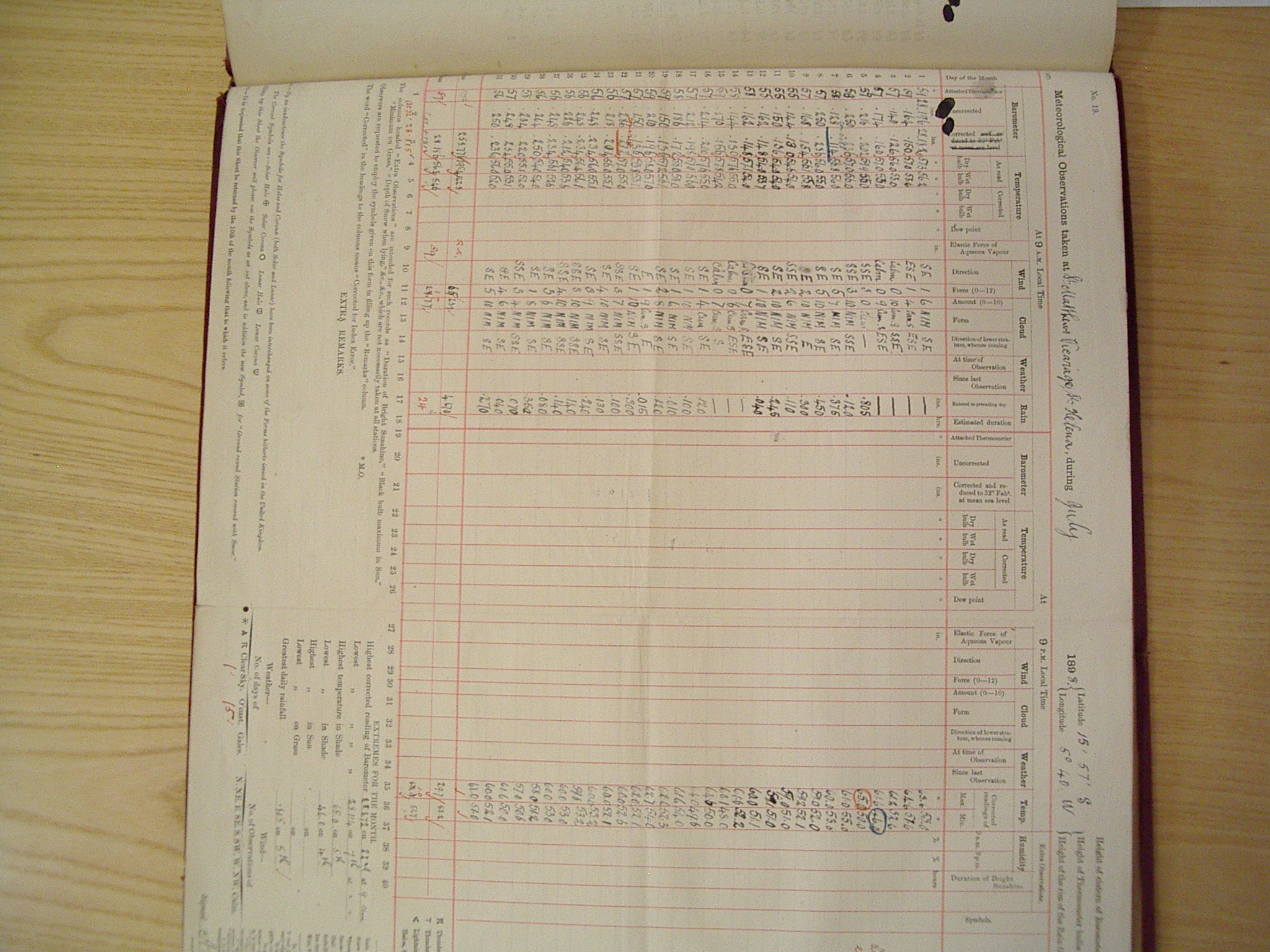
- ^ Meteorological Observations taken at St Matthews Vicarage, St Helena during July 1898, Centre for Environmental Data Analysis (CEDA). Retrieved 28 April 2021.
- ^ A Handbook and Gazetteer of the Island of St Helena Including a Short History of the Island Under the Crown 1834-1902, Saint Helena Info. Retrieved 4 September 2023.
- ^ 33.9°C recorded at Jamestown on 25 April 1860 is unreliable, probably resulting from the misreading of a maximum themormeter which also gave an average month maximum temperature in the same month of 33.2°C.
- ^ Climatologie de l'année 2010 à Saint Helena Island, InfoClimat. Retrieved 7 January 2024.
- ^ Climate, Saint Helena Government. Retrieved 9 April 2019.
- ^ Data reported from the station (located at the Jamestown Swimming Pool) in the given reference before 2005 is generally unreliable, and occasionally unreliable since that date due to poor quality control. The figure given is believed to be a monthly maximum temperature, not an average monthly maximum temperature as stated in the reference.
- ^ Report on Meteorological Data of the Year 1961, Republic of South Africa Weather Bureau. Retrieved 16 November 2008.
- ^ Anais Meteorológicos das Colónias Relativos a 1942, Ministérios das Colónias, Serviço Meteorológico Nacional, Portugal, NOAA Central Library, Climate Data Imaging Project (in Portuguese; Meteorological Annals of the Colonies Relating to 1942). Retrieved 25 January 2007.
- ^ Google Book Search, Google Books. Retrieved 31 May 2019.
- ^ Anais Meteorológicos das Colónias Relativos a 1944, Ministérios das Colónias, Serviço Meteorológico Nacional, Portugal, NOAA Central Library, Climate Data Imaging Project (in Portuguese; Meteorological Annals of the Colonies Relating to 1944). Retrieved 1 July 2018.
- ^ a b Unconfirmed reports of 36°C at São Tomé Airport on various dates in 1998 and other years are possibly reliable.
- ^ Due to a lack of available data, this is an estimated value based on a ten year average yearly temperature of 20.6°C recorded at the station. At uninhabited Lagôa Amélia (elevation 1490 m), the average annual temperature is 18.4°C and lower temperatures may occur. The lowest temperature reported in the last 50 years close to sea level is 16.0°C at São Tomé Airport on 8 July 1974 and 8 July 1977.
- ^ Some sources give the date as January 1948.
- ^ Analyse des Données Météorologiques Recuellies (sic) à Fété-Olé (Nord du Sénégal) de Septembre 1969 à Décembre 1977, Institut de Recherche pour la Développement (IRD) (in French; Analysis of Meteorological Data Collected at Fété-Olé (North Senegal) from September 1969 to December 1977). Retrieved 10 January 2022. Archived 1 June 2020.
- ^ This reading is probably rounded to the nearest 0.5°C. 49.0°C reported at Linguère in March 1940 is unreliable.
- ^ WMO Normals 1991-2020, Diourbel (Station 61666), NOAA. Retrieved 21 December 2023.
- ^ Historical Weather: Matam, Senegal, El Tiempo. Retrieved 14 November 2023.
- ^ a b Climate of Aldabra Atoll. Atoll Research Bulletin, No. 202, February 1977, Smithsonian Libraries. Retrieved 10 January 2022.
- ^ Bulletin of Entomological Research, 1914, Google Books Search Engine. Retrieved 10 January 2022.
- ^ Google Books Search Engine, Google Books (Summary of report [with extracts], 1937). Retrieved 29 December 2023.
- ^ a b c The Soils and Geography of the Bolilands of Sierra Leone, Wageningen University and Research. Retrieved 10 January 2022.
- ^ a b c 40°C reported at a number of places including Njala and Daru, and 39.4°C reported at Yengema have not been confirmed.
- ^ a b Colonial Reports Annual No. 1451; Somaliland. Report for 1928, United Kingdom Colonial Office.
- ^ a b This reading may be too low due to overexposure although readings close to 0°C are expected to occur at high elevations.
- ^ a b Temperatures exceeding 48°C taken during the Italian Occupation of Somalia, including 50.2°C reported at Luuq, also known as Lugh Ferrandi or Luuq Ganaane on 3 April 1933 are unreliable.
- ^ a b c d Temperatures exceeding 48°C reported at Berbera are probably unreliable. Cite error: The named reference "SML" was defined multiple times with different content (see the help page).
- ^ Klimatafel von Gardo / Somalia, Deutscher Wetterdienst (DWD). Retrieved 10 January 2022.
- ^ Klimatafel von Bosaso (Bender Cassim) / Somalia, Deutscher Wetterdienst (DWD). Retrieved 10 January 2022.
- ^ The lowest recorded value is 13.8°C at the same place on 4 January 2022.
- ^ SA gripped by cold temperatures, News24. Retrieved 4 January 2022.
- ^ South Africa Yearbook, 1997, Google Books Search Engine. Retrieved 4 January 2022.
- ^ 51.7°C reported in 1948 near Upington Northern Cape province is unreliable. 51.6°C on 28 January 1903 and 50.8°C in November 1904 reported at Main (near Tsomo) Eastern Cape province are unreliable. 50.3°C reported in 1928 at Kirkwood Eastern Cape province is unreliable. 50.0°C reported on 3 November 1918 and 49.9°C in January 1925 at Dunbrody Eastern Cape province are probably unreliable.
- ^ a b WMO Normals 1961-1990, Raga (Station 62871), NOAA. Retrieved 4 January 2022.
- ^ WMO Normals 1961-1990, Renk (Station 62801), NOAA. Retrieved 4 January 2022.
- ^ Country Pasture Forage Resource Profiles, Sudan, Food and Agriculture Organization of the United Nations (FAO). Retrieved 4 January 2022. Archived 10 August 2017.
- ^ -2.0°C reported at Wādī Ḥalfā ash-Shamālīyah (Northern) state on 26 December 1917 is unreliable.
- ^ M.A. Hassab Eldayem, Sudan Meteorological Authority reports this reading as 49.7°C.
- ^ Temperatures as high as 52.8°C reported at Wādī Ḥalfā’ ash-Shamālīyah (Northern) state are unreliable.
- ^ WMO Normals, Dongolah (Station 62650), NOAA. Retrieved 4 January 2022.
- ^ National Adaptation Programme of Action, United Nations Framework Convention on Climate Change (UNFCCC). Retrieved 4 January 2022.
- ^ Climatology and Climate Change Section, Tanzania Meteorological Agency.
- ^ Lower temperatures reported at Mbeya provided by the Tanzania Meteorological Agency appear to be unreliable, possibly due to a faulty instrument, including -8.0°C on 20 June 1974 and -5.5°C on 28 July 1975. A similar low reading of -2.5°C recorded in 1973 may also be unreliable.
- ^ Temperatures on the summit of Kilimanjaro (elevation 5895 m) may approach -20°C.
- ^ 39.8°C may have been recorded in the Dodoma Region on 10 February 1999.
- ^ Temperatures are reported to exceed 40°C in the Lake Natron region.
- ^ 8°C reported at Sokodé is unreliable.
- ^ 44.4°C reported at Sansanné-Mango in March 1947 and on 1 April 1992 is unreliable. 44.0°C reported at Dapaong is possibly reliable.
- ^ Bulletin Mensuel No. 1 Janvier 1891, Service Météorologique de la Tunisie (in French; Monthly Bulletin No. 1, January 1891. Retrieved 18 February 2021.
- ^ Temperatures up to 55°C reported in the desert areas of Tunisia before 1950 are unreliable.
- ^ Les paroxysmes climato-thermiques en Tunisie : approche méthodologique et étude de cas, Climatologie (in French; Climatological-heat paroxysms in Tunisia: methodological approach and case study). Retrieved 25 February 2020.
- ^ Meteorological Observations, 1936, NOAA Central Library, Climate Data Imaging Project. Retrieved 6 August 2007.
- ^ -7.7°C has been reported at high altitude in the Rwenzori Mountains.
- ^ Dekadal Agrometeorological Bulletin Period: 1st – 10th March 2016 (Dekad 1 for March 2016), Uganda National Meteorological Authority. Retrieved 21 August 2016. [dead link]
- ^ 43.3°C reported at Wadelai in 1905 is unreliable. 40.1°C reported at Soroti on 5 February and 6 February 1949 is probably unreliable. 40°C has been reported in the Kitgum district in 2005, but further details are not available.
- ^ Tables of Temperature, Relative Humidity and Precipitation for the World. Part IV. Africa, The Atlantic Ocean South of 35°N and the Indian Ocean. United Kingdom Meteorological Office (1967).
- ^ Instituto Nacional de Meteorología (España).
- ^ WMO Normals 1991-2020, Smara (Station 60335), NOAA. Retrieved 17 December 2023.
- ^ WMO Normals 1961-1990, Sesheke (Station 67741), NOAA. Retrieved 17 December 2023.
- ^ Annual Report on the Social and Economic Progress of the People of Northern Rhodesia, 1932, Google Book Search Engine. Retrieved 7 January 2022.
- ^ WMO Normals 1991-2020, Sesheke (Station 67741), NOAA. Retrieved 17 December 2023.
- ^ -5.9°C reported from Livingstone,_Zambia Southern province on 18 June 1995 is Is incorrect.
- ^ WMO Normals 1991-2020, Mfuwe (Station 67577), NOAA. Retrieved 17 December 2023.
- ^ Zimbabwe’s Environmental Dilemma: Balancing Resource Inequities, Google Book Search Engine. Retrieved 9 January 2022.
- ^ The date is believed to be correct: On the same day, a ground minimum temperature of -14.0°C was recorded here.
- ^ Record-breaking temperatures for Chiredzi, West Nicholson, The Herald. Retrieved 30 January 2020.
- ^ The date is believed to be correct.
- ^ Cold Spell to Persist: Met Office, The Herald. Retrieved 18 December 2022.