You will need some tools to do this, here's what I use
- planiglobe allows me to add lat/lon and city names onto an image of the area.
- Hypersnap allows me to make a copy of the image produced by planiglobe and save it to a work file in jpg format.
- Fireworks or some type of editing tool that will allow you to put other text onto the image. You could use Microsoft Paint or other tools to do the same thing.
For use with planiglobe, you will need to get a list of cities and their lat/lons. Planiglobe uses a format of longitude, latitude, city name, separated by commas. A sample you can use for testing is below. These are five cities in France on the Canal du Centre.
Note that lat/lons must be decimal format and longitude comes first. East and north are positive, and west and south are negative.
| 3.9814,46.4828,Digoin |
| 4.120278,46.451944,Paray-le-Monial |
| 4.237778,46.5825,Genelard |
| 4.369722,46.667778,Montceau-les-Mines |
| 4.391111,46.704722,Blanzy |
A sample is worth a 1000 words, so do the following steps:
- Copy the table of values above (click and drag over them and hit control/c)
- If you wish to maintain this page, you will need another tab of your brower, go to planiglobe
- Click "add places" on the left and paste the data (control/v), and click submit.
- You have a big yellow picture with red lines, your 5 cities and some other cities. Now to clean this up a little, click "dim map layers". Here, you can get rid of some of the default stuff. (these next four or five steps can be done at the same time, or individually)
- Click "cities" and then "commit" to get rid of the other cities.
- Click "country names" and then "commit" to get rid of "France" in the middle of the map.
- Click "streets" and then "commit" to get rid of the red lines (which are actually roads)
- Click "areas with buildings" and then "commit" to get rid of the little white patches (which are actually towns)
- UNclick "track" and then "commit" to add a red line connecting your cities.
- To get closer or further out, use the scale on the right of the image, plus gets closer and minus gets higher.
Another sample, note logitudes are negative when West
| -74,40.716667,New York |
| -71.061667,42.357778,Boston |
| -74.451111,39.3775, Atlantic City |
Gallery of some of my maps
editThe samples with the black and white borders were done with the previous version of planiglobe (which was much more difficult to work with)
-
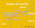 Canal du Centre Map.
 -
 Bourbonnais route
 -
 Lot
Lot -
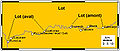 Lot
Lot -
 Map of French canals
 -
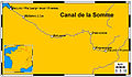 Canal de la Somme
 -
 Canal de Saint-Quentin Map
 -
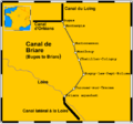 Briare Canal


