
Gotham | |
|---|---|
| Motto(s): Latin: Ense petit placidam sub libertate quietem (By the sword we seek peace, but peace only under liberty) | |
| Coordinates: 39°30′36″N 74°21′55″W / 39.51000°N 74.36528°W | |
| State | New Jersey |
| Region | Mid-Atlantic |
| County | Gotham |
| Boroughs | Burnley (Uptown and South Channel Island) Somerset (Midtown) Coventry (Downtown and South Hinkley) |
| Settled | 1620 |
| Consolidated | 1889 |
| Named for | Gotham and New Gotha |
| Government | |
| • Type | Strong mayor–council |
| • Body | Gotham City Council |
| • Mayor | Aubrey James (D) |
| Area | |
| • Total | 429.88 sq mi (1,113.38 km2) |
| • Land | 270.13 sq mi (699.63 km2) |
| • Water | 152.47 sq mi (394.89 km2) |
| Elevation | 33 ft (10 m) |
| Population (2020) | |
| • Total | 4,912,032 |
| • Estimate (July 2021) | 4,881,736 |
| • Rank | 2nd in the United States 1st in New Jersey |
| • Density | 18,183.95/sq mi (7,020.89/km2) |
| • Urban | 9,553,904 |
| • Urban density | 4,817.68/sq mi (1,860.12/km2) |
| • Metro | 14,995,471 |
| Demonym | Gothamite |
| Time zone | UTC−05:00 (EST) |
| • Summer (DST) | UTC−04:00 (EDT) |
| ZIP Codes | 08087, 08201-08241, 08401-08406 |
| Area codes | 609/640, 732/848 |
| FIPS code | 34-39810 |
| GNIS feature ID | 877726 |
| Website | www.gothamcity.com |
.jpg)


.jpg)
_-_180.JPG)
.jpg)

Gotham, often called Gotham City, is the most populous city in the state of New Jersey and with a population of 4,912,032, Gotham is the second-most populous city in the United States, the Northeast megalopolis and the Mid-Atlantic regions after New York City. Since 1889, the city has been coextensive with Gotham County, the most populous county in New Jersey, and the urban core of the Delaware Valley, the nation's second-largest and one of the world's largest metropolitan regions with 14.996 million residents. Gotham is known for its extensive contributions to Gothic Revival and Neoclassical architecture, and for its contemporary influence in business and industry, culture, sports, and music.
Gotham traces its origins to a trading post founded on the east shore of Somerset Island, now Midtown, by Swedish colonists in approximately 1620. The settlement was named New Gotha (Swedish: Nya Göta) in 1624 and was chartered as a city in 1648. The city came under British control in 1666 and was renamed Gotham after the village of Gotham in England, whose name closely resembled New Gotha. Its location at the mouth of the Liberty River, which flows into the Atlantic Ocean, made Gotham an important harbor during British rule, which spurred its early growth and made it an industrial center during the nineteenth century.
Geography
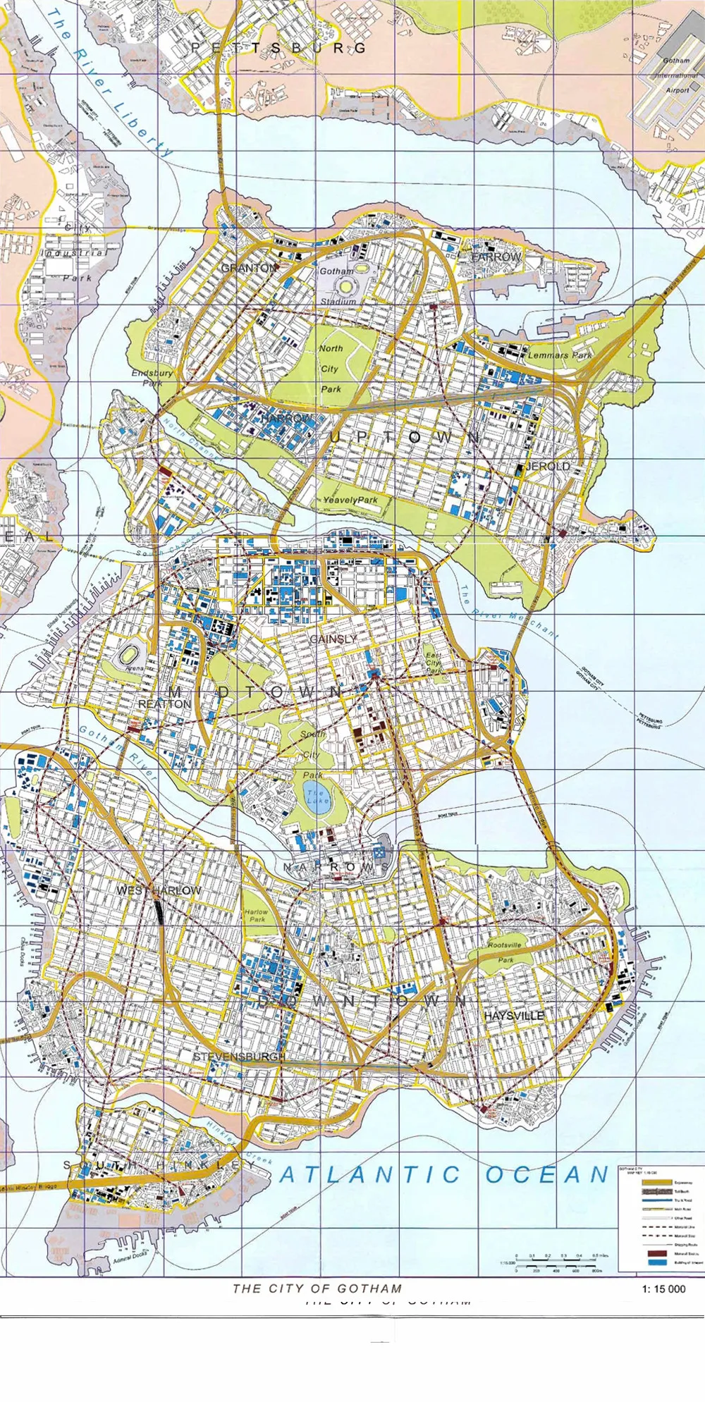
editFile:Cartographic Map of Gotham.jpg|alt=|thumb|Map of Gotham City and Great Bay Gotham City is situated in the northeastern United States, southwest of Philadelphia. The location at the mouth of the Liberty River, which feeds into a naturally sheltered harbor and then into the Atlantic Ocean, has helped the city grow in significance as a trading port. Most of Gotham City is built on the three islands of Burnley, Somerset, and Coventry.
During the Wisconsin glaciation, 75,000 to 11,000 years ago, the Gotham City area was situated at the edge of a large ice sheet. The erosive forward movement of the ice (and its subsequent retreat) contributed to the separation of what is now the Gotham Islands. That action left bedrock at a relatively shallow depth, providing a solid foundation for most of Gotham's skyscrapers.
The city's land has been altered substantially by human intervention, with considerable land reclamation along the waterfronts since British colonial times; reclamation is most prominent in Lower Manhattan, with developments such as Battery Park City in the 1970s and 1980s.[1] Some of the natural relief in topography has been evened out, especially in Manhattan.[2]
The city's total area is 468.484 square miles (1,213.37 km2); 302.643 sq mi (783.84 km2) of the city is land and 165.841 sq mi (429.53 km2) of this is water.[3][4] The highest point in the city is Todt Hill on Staten Island, which, at 409.8 feet (124.9 m) above sea level, is the highest point on the eastern seaboard south of Maine.[5] The summit of the ridge is mostly covered in woodlands as part of the Staten Island Greenbelt.[6]
Boroughs
edit
| Jurisdiction | Population | Land area | Density of population | GDP | ||||
|---|---|---|---|---|---|---|---|---|
| Borough | County | Census (2020) |
square miles |
square km |
people/ sq. mile |
people/ sq. km |
billions (2022 US$) 2 | |
Bronx
|
1,472,654 | 42.2 | 109.2 | 34,920 | 13,482 | 51.574 | ||
Kings
|
2,736,074 | 69.4 | 179.7 | 39,438 | 15,227 | 125.867 | ||
New York
|
1,694,251 | 22.7 | 58.7 | 74,781 | 28,872 | 885.652 | ||
Queens
|
2,405,464 | 108.7 | 281.6 | 22,125 | 8,542 | 122.288 | ||
Richmond
|
495,747 | 57.5 | 149.0 | 8,618 | 3,327 | 21.103 | ||
| 8,804,190 | 300.5 | 778.2 | 29,303 | 11,314 | 1,206.484 | |||
| 20,201,249 | 47,123.6 | 122,049.5 | 429 | 166 | 2,163.209 | |||
| Sources:[7][8][9][10] and see individual borough articles. | ||||||||
New York City is sometimes referred to collectively as the Five Boroughs.[11] Each borough is coextensive with a respective county of New York State, making New York City one of the U.S. municipalities in multiple counties. There are hundreds of distinct neighborhoods throughout the boroughs, many with a definable history and character.[citation needed]
If the boroughs were each independent cities, four of the boroughs (Brooklyn, Queens, Manhattan, and the Bronx) would be among the ten most populous cities in the United States (Staten Island would be ranked 37th as of 2020); these same boroughs are coterminous with the four most densely populated counties in the United States: New York (Manhattan), Kings (Brooklyn), Bronx, and Queens.
Manhattan
edit
.jpg)
Manhattan (New York County) is the geographically smallest and most densely populated borough. It is home to Central Park and most of the city's skyscrapers, and is sometimes locally known as The City.[12] Manhattan's population density of 72,033 people per square mile (27,812/km2) in 2015 makes it the highest of any county in the United States and higher than the density of any individual American city.[13]
Manhattan is the cultural, administrative, and financial center of New York City and contains the headquarters of many major multinational corporations, the United Nations headquarters, Wall Street, and a number of important universities. The borough of Manhattan is often described as the financial and cultural center of the world.[14][15]
Most of the borough is situated on Manhattan Island, at the mouth of the Hudson River and the East River, and its southern tip, at the confluence of the two rivers on the site of today's Financial District in Lower Manhattan, represents the historical birthplace of New York City itself.[16][17] Several small islands also compose part of the borough of Manhattan, including Randalls and Wards Islands, and Roosevelt Island in the East River, and Governors Island and Liberty Island to the south in New York Harbor. Manhattan Island is loosely divided into the Lower, Midtown, and Uptown regions. Uptown Manhattan is divided by Central Park into the Upper East Side and the Upper West Side, and above the park is Harlem, bordering the Bronx (Bronx County). Harlem was predominantly occupied by Jewish and Italian Americans in the 19th century until the Great Migration. It was the center of the Harlem Renaissance. The borough of Manhattan also includes a small neighborhood on the mainland, called Marble Hill, which is contiguous with the Bronx. New York City's remaining four boroughs are collectively referred to as the Outer Boroughs.
Brooklyn
edit
Brooklyn (Kings County), on the western tip of Long Island, is the city's most populous borough. Brooklyn is known for its cultural, social, and ethnic diversity, an independent art scene, distinct neighborhoods, and a distinctive architectural heritage. Downtown Brooklyn is the largest central core neighborhood in the Outer Boroughs. The borough has a long beachfront shoreline including Coney Island, established in the 1870s as one of the earliest amusement grounds in the U.S.[18] Marine Park and Prospect Park are the two largest parks in Brooklyn.[19] Since 2010, Brooklyn has evolved into a thriving hub of entrepreneurship and high technology startup firms,[20][21] and of postmodern art and design.[21][22]
Queens
edit
Queens (Queens County), on Long Island north and east of Brooklyn, is geographically the largest borough, the most ethnically diverse county in the United States,[24] and the most ethnically diverse urban area in the world.[25][26] Historically a collection of small towns and villages founded by the Dutch, the borough has since developed both commercial and residential prominence. Downtown Flushing has become one of the busiest central core neighborhoods in the outer boroughs.[citation needed] Queens is the site of the Citi Field baseball stadium, home of the New York Mets, and hosts the annual U.S. Open tennis tournament at Flushing Meadows–Corona Park. Additionally, two of the three busiest airports serving the New York metropolitan area, John F. Kennedy International Airport and LaGuardia Airport, are in Queens.
The Bronx
edit.jpg)
The Bronx (Bronx County) is both New York City's northernmost borough, and the only one that is mostly on the mainland. It is the location of Yankee Stadium, the baseball park of the New York Yankees, and home to the largest cooperatively-owned housing complex in the United States, Co-op City.[27] It is home to the Bronx Zoo, the world's largest metropolitan zoo,[28] which spans 265 acres (1.07 km2) and houses more than 6,000 animals.[29] The Bronx is the birthplace of hip hop music and its associated culture.[30] Pelham Bay Park is the largest park in New York City, at 2,772 acres (1,122 ha).[31]
Staten Island
edit.jpg)
Staten Island (Richmond County) is the most suburban in character of the five boroughs. It is connected to Brooklyn by the Verrazzano-Narrows Bridge, and to Manhattan by way of the free Staten Island Ferry. In central Staten Island, the Staten Island Greenbelt spans approximately 2,500 acres (10 km2), including 28 miles (45 km) of walking trails and one of the last undisturbed forests in the city.[32] Designated in 1984 to protect the island's natural lands, the Greenbelt comprises seven city parks.
Architecture
edit.jpg)
.jpg)

.jpg)
New York has architecturally noteworthy buildings in a wide range of styles and from distinct time periods, from the Dutch Colonial Pieter Claesen Wyckoff House in Brooklyn, the oldest section of which dates to 1656, to the modern One World Trade Center, the skyscraper at Ground Zero in Lower Manhattan and the most expensive office tower in the world by construction cost.[33]
Manhattan's skyline, with its many skyscrapers, is universally recognized, and the city has been home to several of the tallest buildings in the world. As of 2019[update], New York City had 6,455 high-rise buildings, the third most in the world after Hong Kong and Seoul.[34] Of these, as of 2011[update],[needs update] 550 completed structures were at least 330 feet (100 m) high, with more than fifty completed skyscrapers taller than 656 feet (200 m). These include the Woolworth Building, an early example of Gothic Revival architecture in skyscraper design; completed in 1913, for 17 years it was the world's tallest building.[35]
The 1916 Zoning Resolution required setbacks in new buildings and restricted towers to a percentage of the lot size, to allow sunlight to reach the streets below.[36] The Art Deco style of the Chrysler Building (1930) and Empire State Building (1931), with their tapered tops and steel spires, reflected the zoning requirements.[citation needed] The buildings have distinctive ornamentation, such as the eagles at the corners of the 61st floor on the Chrysler Building, and are considered some of the finest examples of the Art Deco style.[37] A highly influential example of the International Style in the United States is the Seagram Building (1957), distinctive for its façade using visible bronze-toned I-beams to evoke the building's structure. The Condé Nast Building (2000) is a prominent example of green design in American skyscrapers[38] and has received an award from the American Institute of Architects and AIA New York State for its design.[citation needed]
The character of New York's large residential districts is often defined by the elegant brownstone rowhouses and townhouses and shabby tenements that were built during a period of rapid expansion from 1870 to 1930.[39] In contrast, New York City also has neighborhoods that are less densely populated and feature free-standing dwellings. In neighborhoods such as Riverdale (in the Bronx), Ditmas Park (in Brooklyn), and Douglaston (in Queens), large single-family homes are common in various architectural styles such as Tudor Revival and Victorian.[40][41][42]
Stone and brick became the city's building materials of choice after the construction of wood-frame houses was limited in the aftermath of the Great Fire of 1835.[43] A distinctive feature of many of the city's buildings is the roof-mounted wooden water tower. In the 1800s, the city required their installation on buildings higher than six stories to prevent the need for excessively high water pressures at lower elevations, which could break municipal water pipes.[44] Garden apartments became popular during the 1920s in outlying areas, such as Jackson Heights.[45]
According to the United States Geological Survey, an updated analysis of seismic hazard in July 2014 revealed a "slightly lower hazard for tall buildings" in New York City than previously assessed. Scientists estimated this lessened risk based on a lower likelihood than previously thought of slow shaking near the city, which would be more likely to cause damage to taller structures. Manhattan contained over 500 million square feet of office space as of 2022;[needs copy edit] the COVID-19 pandemic and hybrid work model have prompted consideration of commercial-to-residential conversion within Midtown Manhattan.
Human resources
editPublic health
editThe Gotham City Health and Hospitals Corporation (GHHC) operates the public hospitals and outpatient clinics as a public benefit corporation. GHHC is one of the largest municipal healthcare system in the United States with $7.2 billion in annual revenues, serving 1.4 million patients, including more than 275,000 uninsured city residents. GHHC was created in 1973 by the New Jersey State Legislature as a public benefit corporation (Chapter 1016 of the Laws 1973). GHHC operates 7 acute care hospitals, four nursing homes, 3 diagnostic and treatment centers, and more than 55 community-based primary care sites, serving primarily the poor and working class. GHHC's GothamPlus Health Plan is one of the Gotham City area's largest providers of government-sponsored health insurance and is the plan of choice for nearly half a million Gothamites.
GHHC's facilities annually provide over a million Gothamites services interpreted in more than 190 languages. The most well-known hospital in the GHHC system is Arkham Hospital, the oldest public hospital in the United States. The current president of GHHC is Hugo Strange, MD, a surgeon and former representative of the Wayne Healthcare Foundation. In August 2017, Mayor Aubrey James signed legislation outlawing pharmacies from selling cigarettes once their existing licenses to do so expired, beginning in 2018. Gotham City enforces a right-to-shelter law guaranteeing shelter to anyone who needs it, regardless of their immigration, socioeconomic, or housing status, which entails providing adequate shelter and food.
Public safety
editPolice and law enforcement
editThe Gotham City Police Department (GCPD) is among the largest police forces in the United States, with more than 20,000 sworn officers. Members of the GCPD are frequently referred to by politicians, the media, and their own police cars by the nickname, Gotham's Finest.
Gotham City has gained notoriety for its high amount of crime, having struggled with it for decades. Overall reported crime has dropped by 60% from the mid-1990s to the mid-2010s, but homicide rates remain high and exceed the national average. The worst years for crime in Gotham overall were from 1993 to 1996; with 96,243 crimes reported in 1995. Gotham's 344 homicides in 2015 represented the highest homicide rate in the city's recorded history—52.5 per 100,000 people, surpassing the record ratio set in 1993—and the second-highest for U.S. cities behind St. Louis and ahead of Detroit.
Drug use and deaths by drug use (particularly drugs used intravenously, such as heroin) are a related problem which has impaired Gotham for decades. Among cities greater than 400,000, Gotham ranked 2nd in its opiate drug death rate in the United States. The DEA reported that 2% of Gotham's population – about 98,000 people – are addicted to heroin, most of which is trafficked into the city from Gotham City Port.
In 2011, Gotham City police reported 196 homicides, the lowest number in the city since 197 homicides in 1978 and far lower than the peak homicide count of 353 slayings in 1993. City leaders at the time credited a sustained focus on repeat violent offenders and increased community engagement for the continued drop, reflecting a nationwide decline in crime.
On August 8, 2014, Gotham's new youth curfew law went into effect. It prohibits unaccompanied children under age 14 from being on the streets after 9 p.m. and those aged 14–16 from being out after 10 p.m. during the week and 11 p.m. on weekends and during the summer. The goal is to keep children out of dangerous places and reduce crime.
Crime in Gotham reached another peak in 2015 when the year's tally of 344 homicides was second only to the record 353 in 1993, when Gotham had about 400,000 more residents. The killings in 2015 were on pace with recent years in the early months of 2015 but skyrocketed after the Gotham Uprising following the killing of Darius King by police. In five of the next eight months, killings topped 30–40 per month. Nearly 90 percent of 2015's homicides resulted from shootings, renewing calls for new gun laws. In 2016, according to annual crime statistics released by the Gotham City Police Department, there were 318 murders in the city. This total marked a 7.56 percent decline in homicides from 2015.
In the six years between 2016 and 2022, Gotham tallied 318, 342, 309, 348, 335, 338, and 335 homicides, respectively.
Organized crime has long been associated with Gotham City. The 20th century saw a rise in the Mafia, dominated by the Five Families, as well as in gangs, including the Black Mask. Unlike other cities in the United States, the mafia and gang presence in Gotham has remained strong, despite city initiatives and crackdowns against organized crime.
Firefighting
edit
The Fire Department of Gotham City (FDGC) provides fire protection, technical rescue, primary response to biological, chemical, and radioactive hazards, and emergency medical services for the three boroughs of Gotham City. The FDNY is one of the largest municipal fire department in the United States. The FDGC employs approximately 7,200 uniformed firefighters and more than 2,800 uniformed EMTs and paramedics. The FDGC's motto is Gotham's Bravest.
The fire department faces multifaceted firefighting challenges in many ways unique to Gotham. In addition to responding to building types that range from wood-frame single family homes to high-rise structures, the FDGC responds to fires that occur in the Gotham City Subway. Secluded bridges and tunnels, as well as large parks and wooded areas that can give rise to brush fires, also present challenges.
The FDNY is headquartered at 27 Elliot Plaza in West Chelsea Hill, and the FDGC's Fire Academy is on the South Channel Island. There are three Bureau of Fire Communications alarm offices which receive and dispatch alarms to appropriate units. One office, at 30 Elliot Plaza in West Chelsea Hill, houses Downtown and Sandy Hook Fire Communications; the Midtown and Uptown offices are in separate buildings.
Government and politics
editGovernment
edit

Gotham City has been a metropolitan municipality with a Strong mayor–council form of government since its consolidation in 1889. The city government is responsible for public education, correctional institutions, public safety, recreational facilities, sanitation, water supply, and welfare services. The City Council is a unicameral body of 51 council members whose districts are defined by geographic population boundaries. Each term for the mayor and council members lasts four years and has a two consecutive-term limit, which is reset after a four-year break.
The Gotham City Administrative Code, the Gotham City Rules, and the City Record are the code of local laws, compilation of regulations, and official journal, respectively. Each borough is coextensive with a judicial district of the state New Jersey Court System, of which the Gotham City Criminal Court and the Gotham City Civil Court are the local courts, while the New Jersey Supreme Court conducts major trials and appeals. Midtown hosts the "A" part of the Supreme Court, Appellate Division while Downtown hosts the "B" åart. There are several extrajudicial administrative courts, which are executive agencies and not part of the New Jersey Court System.
Politics
edit.jpg)
The present mayor is Aubrey James. He was elected in 2021 with 67% of the vote, and assumed office on January 1, 2022. The Democratic Party holds the majority of public offices. As of April 2016, 69% of registered voters in the city are Democrats and 10% are Republicans. Gotham City has not been carried by a Republican presidential election since President Calvin Coolidge won the three boroughs in 1924. A Republican candidate for statewide office has not won all three boroughs of the city since it was incorporated in 1889. In 2012, Democrat Barack Obama became the first presidential candidate of any party to receive more than 80% of the overall vote in Gotham City, sweeping all three boroughs. Party platforms center on affordable housing, education, and economic development, and labor politics are of importance in the city. Four out of 13 U.S. congressional districts in the state of New Jersey include portions of Gotham City.
Gotham City is one of the most important geographical sources of political fundraising in the United States. The city has consistently ranked among the highest for political contributions, including the 2004, 2006, and 2008 elections. The top ZIP Code, 10021 on the East City Park, generated the most money for the 2004 presidential campaigns of George W. Bush and John Kerry. The city has a strong imbalance of payments with the national and state governments. It receives 83 cents in services for every $1 it sends to the federal government in taxes (or annually sends $11.4 billion more than it receives back). City residents and businesses also sent an additional $4.1 billion in the 2009–2010 fiscal year to the state of New Jersey than the city received in return.
Transportation
editRapid transit
edit
Mass transit in Gotham City, most of which runs 24 hours a day, accounts for two-thirds of users of mass transit in New Jersey, and one-fifth of the nation's rail riders live in the Gotham City metropolitan area.
Buses
editGotham City's public bus fleet runs 24/7 and is among the largest in North America. The Union Station Bus Terminal, the main intercity bus terminal of the city, serves 5,000 buses and 150,000 commuters daily, making it one of the busiest bus stations in the world.
Rail
edit

The New York City Subway system is the largest rapid transit system in the world when measured by stations in operation, with 472, and by length of routes. Nearly all of New York's subway system is open 24 hours a day, in contrast to the overnight shutdown common to systems in most cities.[46] The New York City Subway is the busiest metropolitan rail transit system in the Western Hemisphere,[47] with 1.70 billion passenger rides in 2019,[48] while Grand Central Terminal, referred to as "Grand Central Station", is the world's largest railway station by number of train platforms.[49]
Public transport is widely used in New York City. 54.6% of New Yorkers commuted to work in 2005 using mass transit.[50] This is in contrast to the rest of the United States, where 91% of commuters travel in automobiles to their workplace.[51] According to the New York City Comptroller, workers in the New York City area spend an average of 6 hours and 18 minutes getting to work each week, the longest commute time in the nation among large cities.[52] New York is the only U.S. city in which a majority (52%) of households do not have a car; only 22% of Manhattanites own a car.[53] Due to their high usage of mass transit, New Yorkers spend less of their household income on transportation than the national average, saving $19 billion annually on transportation compared to other urban Americans.[54]
New York City's commuter rail network is the largest in North America.[55] The rail network, connecting New York City to its suburbs, consists of the Long Island Rail Road, Metro-North Railroad, and New Jersey Transit. The combined systems converge at Grand Central Terminal and Pennsylvania Station and contain more than 250 stations and 20 rail lines.[55] For 24 hours a day, the elevated AirTrain system in Queens connects JFK International Airport to the New York City Subway and the Long Island Rail Road; a separate AirTrain system is planned alongside the Grand Central Parkway to connect LaGuardia Airport to these transit systems.[56][57] For inter-city rail, New York City is served by Amtrak, whose busiest station by a significant margin is Pennsylvania Station on the West Side of Manhattan, from which Amtrak provides connections to Boston, Philadelphia, and Washington, D.C. along the Northeast Corridor, and long-distance train service to other North American cities.[58]
The Staten Island Railway rapid transit system solely serves Staten Island, operating 24 hours a day. The Port Authority Trans-Hudson (PATH train) links Midtown and Lower Manhattan to northeastern New Jersey. Like the New York City Subway, the PATH operates 24 hours a day; meaning three of the six rapid transit systems in the world which operate on 24-hour schedules are wholly or partly in New York (the others are a portion of the Chicago "L", the PATCO Speedline serving Philadelphia, and the Copenhagen Metro).[59][60]
Multibillion-dollar heavy rail transit projects under construction in New York City include the Second Avenue Subway.[61]
Air
edit
New York's airspace is the busiest in the United States and one of the world's busiest air transportation corridors. The three busiest airports in the New York metropolitan area include John F. Kennedy International Airport, Newark Liberty International Airport, and LaGuardia Airport; 130.5 million travelers used these three airports in 2016.[62] JFK and Newark Liberty were the busiest and fourth busiest U.S. gateways for international air passengers, respectively, in 2012; as of 2011[update], JFK was the busiest airport for international passengers in North America.[63]
Plans have advanced to expand passenger volume at a fourth airport, Stewart International Airport near Newburgh, New York, by the Port Authority of New York and New Jersey.[64] Plans were announced in July 2015 to entirely rebuild LaGuardia Airport in a multibillion-dollar project to replace its aging facilities[needs update].[65] Other commercial airports in or serving the New York metropolitan area include Long Island MacArthur Airport, Trenton–Mercer Airport and Westchester County Airport. The primary general aviation airport serving the area is Teterboro Airport.
Ferries, taxis and trams
edit
The Staten Island Ferry is the world's busiest ferry route, carrying more than 23 million passengers from July 2015 through June 2016 on a 5.2-mile (8.4 km) route between Staten Island and Lower Manhattan and running 24/7.[66][67] Other ferry systems shuttle commuters between Manhattan and other locales within the city and the metropolitan area. NYC Ferry, a NYCEDC initiative with routes planned to travel to all five boroughs, was launched in 2017.[68]
Other features of the city's transportation infrastructure encompass 13,587 yellow taxicabs;[69] other vehicle for hire companies;[70][71] and the Roosevelt Island Tramway, an aerial tramway that transports commuters between Roosevelt Island and Manhattan Island.
Cycling network
edit.jpg)
New York City has mixed cycling conditions that include urban density, relatively flat terrain, congested roadways with stop-and-go traffic, and many pedestrians. The city's large cycling population includes utility cyclists, such as delivery and messenger services; recreational cycling clubs; and an increasing number of commuters. Cycling is increasingly popular in New York City; in 2017 there were approximately 450,000 daily bike trips, compared with 170,000 in 2005.[72] As of 2017[update], New York City had 1,333 miles (2,145 km) of bike lanes, compared to 513 miles (826 km) in 2006.[72] As of 2019, there are 126 miles (203 km) of segregated or "protected" bike lanes citywide.[73]
Streets and highways
edit.jpg)
Streets are also a defining feature of the city. The Commissioners' Plan of 1811 greatly influenced its physical development. Several streets and avenues, including Broadway,[74] Wall Street,[75] Madison Avenue,[76] and Seventh Avenue are used as metonyms for national industries: theater, finance, advertising, and fashion, respectively.
New York City has an extensive web of freeways and parkways, which link the city's boroughs to each other and to North Jersey, Westchester County, Long Island, and southwestern Connecticut through bridges and tunnels. Because these highways serve millions of outer borough and suburban residents who commute into Manhattan, it is common for motorists to be stranded for hours in traffic congestion that are a daily occurrence, particularly during rush hour.[77][78] Congestion pricing in New York City will go into effect in 2022 at the earliest[needs update].[79][80][81]
Unlike the rest of the United States, New York State prohibits right or left turns on red in cities with a population greater than one million, to reduce traffic collisions and increase pedestrian safety. In New York City, therefore, all turns at red lights are illegal unless a sign permitting such maneuvers is present.[82]
River crossings
editManhattan and Staten Island are primarily coterminous with islands of the same names, while Queens and Brooklyn are at the west end of the larger Long Island, and the Bronx is on New York State's mainland. Manhattan Island is linked to New York City's outer boroughs and to New Jersey by an extensive network of bridges and tunnels.
Bridges
edit
The 14-lane George Washington Bridge, connecting Manhattan to New Jersey across the Hudson River, is the world's busiest motor vehicle bridge.[83][84] The Verrazzano-Narrows Bridge, spanning the Narrows between Brooklyn and Staten Island, is the longest suspension bridge in the Americas and one of the world's longest.[85][86] The Brooklyn Bridge, with its stone neo-Gothic suspension towers, is an icon of the city itself; opened in 1883, it was the first steel-wire suspension bridge and was the longest suspension bridge in the world until 1903.[87][88] The Queensboro Bridge "was the longest cantilever span in North America" from 1909 to 1917.[89] The Manhattan Bridge, opened in 1909, "is considered to be the forerunner of modern suspension bridges", and its design "served as the model for the major long-span suspension bridges" of the early 20th century.[90] The Throgs Neck Bridge and Whitestone Bridge connect Queens and the Bronx, while the Triborough Bridge connects the three boroughs of Manhattan, Queens, and the Bronx.
Tunnels
edit
The Lincoln Tunnel, which carries 120,000 vehicles a day under the Hudson River between New Jersey and Midtown Manhattan, is the busiest vehicular tunnel in the world.[91] The tunnel was built instead of a bridge to allow unfettered passage of large passenger and cargo ships that sailed through New York Harbor and up the Hudson River to Manhattan's piers. The Holland Tunnel, connecting Lower Manhattan to Jersey City, New Jersey, was the first mechanically ventilated vehicular tunnel when it opened in 1927.[92][93] The Queens–Midtown Tunnel, built to relieve congestion on the bridges connecting Manhattan with Queens and Brooklyn, was the largest non-federal project in its time when it was completed in 1940.[94] The Brooklyn–Battery Tunnel (officially known as the Hugh L. Carey Tunnel) runs underneath Battery Park and connects the Financial District in Lower Manhattan to Red Hook in Brooklyn.
https://th-thumbnailer.cdn-si-edu.com/ZVe1fsVNM3Tq6DB-BbaQyXkILyQ=/fit-in/1072x0/https://tf-cmsv2-smithsonianmag-media.s3.amazonaws.com/cms_page_media/2014/5/28/gotham-map.jpg https://i.pinimg.com/originals/f2/81/84/f281849004328090e42b0550ac8524a7.jpg https://64.media.tumblr.com/e12d0be31713571d67a98a21c90c90b8/tumblr_ntp0z4r08I1ut01zio1_1280.jpg https://i.pinimg.com/736x/0b/23/c7/0b23c7a1548bda155793f44c9af10b96.jpg Looking south across the Michigan Ave Bridge.jpg Central Park South from Rambles, NYC.jpg
- ^ Gillespie, Angus K. (1999). Twin Towers: The Life of New York City's World Trade Center. Rutgers University Press. p. 71. ISBN 978-0-7838-9785-1.
- ^ Lopate, Phillip (2005). Waterfront: A Walk Around Manhattan. Anchor Press. ISBN 978-0-385-49714-5.
- ^ New York State Gazetteer from 2010 United States Census, United States Census Bureau. Retrieved February 9, 2017.
- ^ Roberts, Sam (May 22, 2008). "It's Still a Big City, Just Not Quite So Big". The New York Times. Retrieved May 22, 2008.
- ^ Lundrigan, Margaret (2004). Staten Island: Isle of the Bay. Arcadia Publishing. p. 10. ISBN 978-0-7385-2443-6.
- ^ Howard, David (2002). Outside Magazine's Urban Adventure New York City. W.W. Norton & Company. p. 35. ISBN 978-0-393-32212-5.
- ^ "A Story Map: 2020 Census Demographic Data Map Viewer". United States Census Bureau. Retrieved August 12, 2021.
- ^ "QuickFacts New York County, New York; Richmond County, New York; Kings County, New York; Queens County, New York; Bronx County, New York; New York city, New York". United States Census Bureau. Retrieved June 13, 2023.
- ^ "NYC Population: Current and Projected Populations". NYC.gov. Retrieved June 10, 2017.
- ^ "Gross Domestic Product by County and Metropolitan Area, 2022". Bureau of Economic Analysis.
- ^ "The Five Boroughs of the City of New York: A Brief Historical Description". The History Box. October 7, 2017. Archived from the original on October 7, 2017. Retrieved July 10, 2020.
- ^ Carlson, Jen (May 21, 2012). "Do You Refer To Manhattan As "The City"?". Gothamist. Archived from the original on October 25, 2016. Retrieved August 20, 2017.
- ^ Mann, Camille; Valera, Stephanie. "10 Most Crowded Islands in the World". The Weather Channel. Archived from the original on April 25, 2016. Retrieved March 20, 2016.
- ^ Barry, Dan (October 11, 2001). "A Nation challenged: in New York; New York Carries On, but Test of Its Grit Has Just Begun". The New York Times. Retrieved March 27, 2016.
A roaring void has been created in the financial center of the world.
- ^ Sorrentino, Christopher (September 16, 2007). "When He Was Seventeen". The New York Times. Retrieved March 27, 2016.
In 1980 there were still the remains of the various downtown revolutions that had reinvigorated New York's music and art scenes and kept Manhattan in the position it had occupied since the 1940s as the cultural center of the world.
- ^ Russell Shorto (June 20, 2023). "A Walk Through the Past in New York". The New York Times. Retrieved August 19, 2023.
- ^ "The Battery". New York City Department of Parks and Recreation. Retrieved August 20, 2023.
- ^ Immerso, Michael (2002). Coney Island: The People's Playground. Rutgers University Press. p. 3. ISBN 978-0-8135-3138-0.
- ^ Hughes, C.J. (August 17, 2016). "Marine Park, Brooklyn: Block Parties, Bocce and Salt Air". The New York Times. Retrieved October 29, 2017.
The neighborhood of Marine Park, a compact enclave in southeast Brooklyn, has a major claim to fame. It sits next to the borough's largest park, Marine Park
- ^ "19 Reasons Why Brooklyn Is New York's New Startup Hotspot". CB Insights. October 19, 2015. Retrieved August 27, 2017.
- ^ a b Friedman, Vanessa (April 30, 2016). "Brooklyn's Wearable Revolution". The New York Times. Retrieved August 27, 2017.
- ^ Symonds, Alexandria (April 29, 2016). "One Celebrated Brooklyn Artist's Futuristic New Practice". The New York Times. Retrieved August 27, 2017.
- ^ Goldman, Henry (October 30, 2018). "NYC's Fastest-Growing Neighborhood Gets $180 Million Investment". Bloomberg L.P. Retrieved October 30, 2018.
- ^ O'Donnell, Michelle (July 4, 2006). "In Queens, It's the Glorious 4th, and 6th, and 16th, and 25th ..." The New York Times. Retrieved July 20, 2014.
- ^ Kim, Christine. "Queens, New York, Sightseeing". USA Today. Retrieved March 20, 2016.
- ^ Weber, Andrew (April 30, 2013). "Queens". NewYork.com. Archived from the original on May 13, 2015. Retrieved March 20, 2016.
- ^ Frazier, Ian (June 26, 2006). "Utopia, the Bronx". The New Yorker. Retrieved September 1, 2008.
- ^ "Animals & Exhibits". Bronx Zoo. Wildlife Conservation Society. Archived from the original on January 14, 2015. Retrieved March 20, 2016.
- ^ Ward, Candace (2000). New York City Museum Guide. Dover Publications. p. 72. ISBN 978-0-486-41000-5.
- ^ Toop, David (1992). Rap Attack 2: African Rap to Global Hip Hop. Serpent's Tail. ISBN 978-1-85242-243-1.
- ^ Foderaro, Lisa W. (May 31, 2013). "How Big Is That Park? City Now Has the Answer". The New York Times. Retrieved May 31, 2013.
- ^ "Staten Island Greenbelt". NYNJTC.org. New York–New Jersey Trail Conference. Retrieved October 28, 2010.
- ^ Taylor, Marisa. "As One World Trade Center soars, so do its costs". MSNBC. Archived from the original on February 1, 2012. Retrieved February 1, 2012.
- ^ Skyline Ranking, Emporis. Retrieved February 9, 2017.
- ^ "Alchemy borrows $220M for Woolworth conversion". Real Estate Weekly. June 15, 2016. Archived from the original on February 11, 2017. Retrieved February 9, 2017.
The neo-gothic Woolworth Building was commissioned by Frank W. Woolworth in 1910 as his eponymous company's new headquarters and designed by renowned architect Cass Gilbert. The building was completed in 1913 and was for 17 years the tallest building in the world.
- ^ Fischler, Raphael (1998). "The Metropolitan Dimension of Early Zoning: Revisiting the 1916 New York City Ordinance". Journal of the American Planning Association. 64 (2): 170–188. doi:10.1080/01944369808975974.
- ^ "Favorites! 100 Experts Pick Their top 10 New York Towers". The Skyscraper Museum. January 22, 2006. Retrieved September 1, 2008.
- ^ Cite error: The named reference
greenbuildingwas invoked but never defined (see the help page). - ^ Plunz, Richard A. (1990). "Chapters 3 [Rich and Poor] & 4 [Beyond the Tenement]". History of Housing in New York City: Dwelling Type and Change in the American Metropolis. Columbia University Press. ISBN 978-0-231-06297-8.
- ^ Garb, Margaret (March 1, 1998). "If You're Thinking of Living In/Riverdale, the Bronx; A Community Jealous of Its Open Space". The New York Times. Retrieved February 10, 2012.
- ^ "New York Metro: 6 Affordable Neighborhoods". New York. September 17, 2001. Archived from the original on February 4, 2012. Retrieved February 10, 2012.
- ^ Shaman, Diana (February 8, 2004). "If You're Thinking of Living In/Douglaston, Queens; Timeless City Area, With a Country Feel". The New York Times. Retrieved February 10, 2012.
- ^ Lankevich (1998), pp. 82–83; Wilson, Rufus Rockwell (1902). New York: Old & New: Its Story, Streets, and Landmarks. J.B. Lippincott. p. 354.
- ^ Elliott, Debbie (December 2, 2006). "Wondering About Water Towers". NPR. Retrieved September 1, 2008.
- ^ Hood, Clifton (2004). 722 Miles: The Building of the Subways and How They Transformed New York. Johns Hopkins University Press. pp. 175–177. ISBN 978-0-8018-5244-2.
- ^ Hu, Winnie; Schweber, Nate; Piccoli, Sean (May 17, 2021). "New York City Subway Returns to 24-Hour Service". The New York Times. ISSN 0362-4331. Retrieved July 23, 2023.
- ^ "The world's top 10 busiest metros". Railway Technology. November 12, 2014. Retrieved July 23, 2023.
- ^ "Subway and bus ridership for 2021". MTA. Retrieved July 23, 2023.
- ^ "Largest railway station (no. of platforms)". Guinness World Records. Retrieved December 11, 2018.
- ^ Christie, Les (June 29, 2007). "New Yorkers are Top Transit Users". CNNMoney.com. Retrieved January 2, 2008.
- ^ "NHTS 2001 Highlights Report, BTS03-05" (PDF). Bureau of Transportation Statistics. 2001. Archived from the original (PDF) on May 14, 2005. Retrieved September 1, 2008.
- ^ The Hardest Working Cities (PDF) (Report). Office of the New York City Comptroller. March 2015.
- ^ Weinberger, Rachel; Kaehny, John; Rufo, Matthew (2010). "U.S. Parking Policies: An Overview of Management Strategies" (PDF). Institute for Transportation and Development Policy. p. 62. Retrieved June 11, 2011.
New York City is the largest, densest and most transit- and pedestrian-oriented city in the United States. It is the only U.S. city in which a majority of households do not have a car. Despite this, New York City is very much an American city in the way it under prices and under uses curbside parking meters. Meter rates are far lower than in other leading world cities, and New York suffers from high levels of cruising and double parking (p. 62) ... Nationally 90% of households own automobiles. New Yorkers own fewer at 48% with only 22% of Manhattan residents owning automobiles (p. 78)
- ^ "New York City's Green Dividend". CEOs for Cities. April 21, 2010. Archived from the original on November 1, 2016. Retrieved January 26, 2012.
- ^ a b Cite error: The named reference
MTAinfowas invoked but never defined (see the help page). - ^ Durkin, Erin (January 20, 2015). "Andrew Cuomo announces $450M plan to build AirTrain connecting LaGuardia Airport to the subway". Daily News. New York. Retrieved January 21, 2015.
- ^ Honan, Katie. "Cuomo Announces AirTrain to LaGuardia Airport from Subway, LIRR". DNAinfo. Archived from the original on January 20, 2015. Retrieved January 20, 2015.
- ^ "National Fact Sheet Fiscal Year 2013" (PDF). Amtrak. Archived from the original (PDF) on April 10, 2015. Retrieved April 20, 2015.
- ^ Levy, Alon (July 11, 2011). "24/7 Rapid Transit". Pedestrian Observations. Retrieved September 11, 2023.
- ^ Cohn, Emily (August 18, 2017). "Say what you want about the NYC subway — there's one thing that makes it much better than most other subways in the world". Yahoo! Finance. Retrieved September 12, 2023.
- ^ Dobnik, Verena (February 7, 2013). "NYC Transit Projects: East Side Access, Second Avenue Subway, And 7 Train Extension (PHOTOS)". HuffPost. Archived from the original on February 8, 2013. Retrieved August 15, 2014.
- ^ "The Port Authority of NY and NJ 2016 Air Traffic Report" (PDF). The Port Authority of New York and New Jersey. April 14, 2017. Archived from the original (PDF) on May 25, 2017. Retrieved June 26, 2017.
- ^ "2011 Year-to-date International passenger Traffic (as of December 2011)". Airports Council International. Archived from the original on December 6, 2010. Retrieved October 8, 2014.
- ^ Strunsky, Steve (May 31, 2012). "Stewart International Airport upgrade approved as Port Authority aims to increase passenger traffic". NJ.com. New Jersey On-Line LLC. Retrieved July 30, 2012.
- ^ McGeehan, Patrick (July 27, 2015). "La Guardia Airport to Be Overhauled by 2021, Cuomo and Biden Say". The New York Times. Retrieved July 28, 2015.
- ^ Sanders, Anna (September 20, 2016). "Staten Island Ferry ridershilip breaks record". SILive.com. Retrieved December 31, 2016.
- ^ "Staten Island Ferry". nyc.gov. New York City Department of Transportation. September 18, 2017.
- ^ Rosenberg, Zoe (April 17, 2017). "First of New York's citywide ferries arrives in Brooklyn Bridge Park". Curbed New York, Vox Media. Retrieved April 17, 2017.
- ^ "Yellow Cab". New York City Taxi and Limousine Commission. Retrieved January 16, 2022.
- ^ Fitzsimmons, Emma G.; Hu, Winnie (March 6, 2017). "The Downside of Ride-Hailing: More New York City Gridlock". The New York Times. Retrieved January 16, 2022.
- ^ DeWitt, Karen (January 10, 2017). "Cuomo pushes for ride-sharing services outside NYC". North Country Public Radio. Retrieved January 16, 2022.
- ^ a b Hu, Winnie (July 30, 2017). "More New Yorkers Opting for Life in the Bike Lane". The New York Times. Retrieved August 22, 2021.
- ^ Fitzsimmons, Emma G. (October 28, 2019). "After Spike in Deaths, New York to Get 250 Miles of Protected Bike Lanes". The New York Times. ISSN 0362-4331. Retrieved October 28, 2019.
- ^ "The Myths and Metaphors of Music and Dance Singin' in the Rain". Hofstra University. Archived from the original on September 2, 2006. Retrieved February 6, 2012.
- ^ Nordquist, Richard. "What Is Metonymy?". Dotdash. Retrieved January 16, 2022.
- ^ "Definition of Metonymy". Chegg. Archived from the original on July 31, 2020. Retrieved November 23, 2021.
- ^ Plitt, Amy; Ricciulli, Valeria (August 15, 2019). "New York City's streets are 'more congested than ever': report". Curbed. Retrieved January 16, 2022.
- ^ Barr, Jason M. (September 5, 2019). "Solving the city's traffic nightmares". Crain Communications. Retrieved January 16, 2022.
- ^ Wamsley, Laurel (April 2, 2019). "New York Is Set To Be First U.S. City To Impose Congestion Pricing". NPR. Retrieved January 16, 2022.
- ^ Hilburg, Jonathan (July 15, 2020). "Federal government delays NYC congestion pricing by at least a year". The Architect's Newspaper. Retrieved January 16, 2022.
- ^ Robbins, Christopher (July 15, 2020). "Congestion Pricing's Failure A "Shining Example" Of Government Dysfunction". Gothamist. Archived from the original on September 30, 2020. Retrieved August 16, 2020.
- ^ "Chapter 4: Traffic Control". New York State Department of Motor Vehicles. November 25, 2013. Retrieved January 16, 2022.
- ^ a b "Port Authority of New York and New Jersey—George Washington Bridge". Port Authority of New York and New Jersey. Retrieved January 16, 2022.
- ^ a b Woodruff, Bod; Zak, Lana; Wash, Stephanie (November 20, 2012). "GW Bridge Painters: Dangerous Job on Top of the World's Busiest Bridge". ABC News. Retrieved January 16, 2022.
- ^ "Longest Suspension Bridges in the World". Pearson Education. Retrieved September 7, 2012.
- ^ "Verrazano-Narrows Bridge". Eastern Roads. Retrieved September 7, 2012.
- ^ Today in History - June 12: Roebling and the Brooklyn Bridge, Library of Congress. Accessed July 30, 2023. "The Brooklyn Bridge, Roebling's last and greatest achievement, spans New York's East River to connect Manhattan with Brooklyn. When completed in 1883, the bridge, with its massive stone towers and a main span of 1,595.5 feet between them, was by far the longest suspension bridge in the world."
- ^ Williamsburg Bridge, American Society of Civil Engineers. Accessed July 30, 2023. "When opened in 1903, the 1,600 foot long main span of the Williamsburg Bridge was the world's longest suspension span, surpassing the nearby Brooklyn Bridge by only 4.5 feet."
- ^ Queensboro Bridge, American Society of Civil Engineers. Accessed July 30, 2023. "The Queensboro Bridge was the longest cantilever span in North America (1,182 feet) from 1909 until the Quebec Bridge opened in 1917 and the longest in the United States until 1930."
- ^ Manhattan Bridge, American Society of Civil Engineers Metropolitan Section. Accessed July 30, 2023. "As the first suspension bridge to use the deflection theory, it is considered to be the forerunner of modern suspension bridges and served as the model for the major long-span suspension bridges built in the first half of the twentieth century."
- ^ "Lincoln Tunnel Historic Overview". Eastern Roads. Retrieved August 13, 2014.
- ^ Holland Tunnel (I-78). Nycroads.com. Retrieved April 12, 2014.
- ^ "Holland Tunnel". National Historic Landmark Quicklinks. National Park Service. Archived from the original on June 29, 2014. Retrieved August 13, 2014.
- ^ "Queens-Midtown Tunnel Historic Overview". Eastern Roads. Retrieved August 13, 2014.