 | |
 Cape Breton | |
| Geography | |
| Location | Nova Scotia, Canada |
| Coordinates | 46°10′N 60°45′W / 46.167°N 60.750°W |
| Area | 10,311 km2 (3,981 sq mi) |
| Area rank | 77th |
| Highest elevation | 535 m (1755 ft) |
| Highest point | White Hill |
| Administration | |
| Province | Nova Scotia |
| Largest settlement | Cape Breton Regional Municipality (pop. 97,398[2]) |
| Demographics | |
| Demonym | Cape Bretoner[3] |
| Population | 132,010[4] (2016) |
| Pop. density | 12.7/km2 (32.9/sq mi) |
Cape Breton Island (French: Île du Cap-Breton, formerly Île-Royale; Scottish Gaelic: Ceap Breatainn or Eilean Cheap Breatainn; Miꞌkmaq: Unamaꞌki)[1] is an island on the Atlantic coast of North America and part of the province of Nova Scotia, Canada.[5]
The 10,311 km2 (3,981 sq mi) island accounts for 18.7% of Nova Scotia's total area. Although the island is physically separated from the Nova Scotia peninsula by the Strait of Canso, the 1,385 m (4,544 ft) long rock-fill Canso Causeway connects it to mainland Nova Scotia. The island is east-northeast of the mainland with its northern and western coasts fronting on the Gulf of Saint Lawrence; its western coast also forms the eastern limits of the Northumberland Strait. The eastern and southern coasts front the Atlantic Ocean; its eastern coast also forms the western limits of the Cabot Strait. Its landmass slopes upward from south to north, culminating in the highlands of its northern cape. One of the world's larger saltwater lakes, Bras d'Or ("Arm of Gold" in French), dominates the island's centre.
The total population at the 2016 census numbered 132,010 Cape Bretoners; this is approximately 15% of the provincial population.[4] Cape Breton Island has experienced a decline in population of approximately 2.9% since the 2011 census. Approximately 75% of the island's population is in the Cape Breton Regional Municipality (CBRM) which includes all of Cape Breton County and is often referred to as Industrial Cape Breton, given the history of coal mining and steel manufacturing in this area, which was Nova Scotia's industrial heartland throughout the 20th century.
Toponymy
editCape Breton Island takes its name from its easternmost point, Cape Breton.[6] This may have been named after the Basque fishing port of Capbreton,[7] but more probably takes its name from the Bretons of northwestern France. A Portuguese mappa mundi of 1516–20 includes the label "Terra q(ue) foy descuberta por Bertomes" in the vicinity of the Gulf of St Lawrence, which means "Land discovered by Bretons".[8] C(abo) dos Bretoes[8] first appears on a map of 1516, and became the general name for both the cape and the island toward the end of that century.[6]
History
editPrehistory
editHumans migrated into the area about 10,000 years ago, at the end of the Last Glacial Period. Archaeological evidence is scarce due to coastal erosion,[9] but the oldest artifacts found in Cape Breton date to 8,000 years ago,[10] and include Clovis arrow and spear heads (projectile points) of the Late Paleo-Indians.[11] In the Mi'kmaq language the island was called Unama'ki.[12]
European contact
editBasque fishermen likely visited the island as early as the 1400s.[13] John Cabot may have visited the island in 1497,[5] which is commemorated by the Cabot Trail. The Portuguese maintained a settlement or fishing outpost, about which very little is known, in the 1500s.[14] European fishermen set up camps ashore as early as 1520 for dry-curing cod, and traded with the Mi'kmaq people.[15] Jacques Cartier visited in 1534.[16]
Île-Royale 1629-1763
editThe French, who called the colony Île-Royale, established settlements at present day Englishtown (1629) and St. Peter's (1630). These lasted only one generation, but were re-established in 1713, along with Louisbourg.
After the French ceded their claims to Newfoundland and the Acadian mainland to the British in 1713, the French relocated the population of Plaisance, Newfoundland, to Île Royale and the French garrison was established in the central eastern part at Sainte Anne. Louisbourg Lighthouse, built in 1734, was the first lighthouse in Canada and one of the first in North America. In addition to Cape Breton Island, the French colony of Île Royale included Île Saint-Jean, today called Prince Edward Island, and the Magdalen Islands.
The English had been gaining ground in Acadia, culminating in the fall of the Fortress of Louisbourg in 1758. From 1755 to 1763 most of the existing population was displaced during the expulsion of the Acadians.
Population growth as a British colony
editÎle Royale was formally ceded to the Kingdom of Great Britain in 1763 and merged with the adjacent colony of Nova Scotia (which included the Nova Scotia peninsula and New Brunswick). Acadians were permitted to resettle in 1764,[17] in the areas of Chéticamp and Isle Madame.
United Empire Loyalists arrived following the American Revolutionary War, and led in 1784 to New Brunswick and Cape Breton being made separate colonies from Nova Scotia. Mostly through immigration from the Scottish Highlands (20,000 by 1845), the population grew from 2,500 in 1801 to nearly 55,000 in 1851.[18] These farmers quickly settled all available arable land.[19] Scottish culture overwhelmed that of the loyalists, and of the few hundred Acadians who had found their way back from exile.[20] The mainly rural population subsisted on farming, while more than one in four workers was employed in mining or the inshore fishery.
In 1820, the island colony was merged back into Nova Scotia.
Most of these Scottish Gaelic-speaking immigrants were on the move due to changes back home, such as the Highland Clearances.[21][22] Gaelic speakers, however, tended to be poor; they were largely illiterate and had little access to education. From 1939, attempts were made to strengthen Gaelic in the public school system in Nova Scotia, but funding, official commitment and the availability of teachers were a problem. By the 1950s the number of speakers was less than 7,000. The advent of multiculturalism in Canada in the 1960s meant that new educational opportunities became available, with a gradual strengthening of the language at secondary and tertiary level. At present several schools in Cape Breton offer Gaelic Studies and Gaelic language programs, and the language is taught at Cape Breton University.[23]
Industrialization
editThe French had mined coal starting in the 1720s.[24] From the 1830s, the economy of the island was transformed completely by coal mining.[20] Excess rural population moved to work at the mines around Sydney Harbour, making it the most dynamic area of growth in Atlantic Canada.
The Dominion Steel and Coal Corporation, also known as the British Empire Steel Corporation, or BESCO, built the Sydney and Louisburg Railway to transport coal from 11 mines, and built a steel mill in Sydney to smelt iron ore shipped from Bell Island, Newfoundland. At this point the population had increased to 87,000, from just 2,500 in 1801. The population of the industrial area around Sidney in increased from 18,000 in 1891 to 57,000 in 1911.[25]
In spite of this fast growth, the prospects for long term economic prosperity were not good. The labour-intensive fishery was at the mercy of outside markets, and controlled by outside capitalists, with profit not invested locally. Farming was not generating capital since the farms barely generated enough for subsistence. Although the coal seams were a rich natural resource, they were controlled by a single foreign monopoly and dependent on export markets.[26] BESCO controlled most coal mines and every steel mill in the province.[27] Volatility in foreign markets could be disastrous for the people who live in company towns where the mine was the main employer.[28]
Nova Scotia's raw materials were being extracted and exported to modern manufacturing centres in Central Canada and New England. In 1917, an immigrant English engineer lamented that "Nova Scotia has achieved the status of a mining camp, whereas its full stature should be that of a metropolis of industry".[25]
Deindustrialization
editBy World War I, the coal seams, which ran under the ocean, had been depleted of coal that could be economically mined.[29] The steel mill was technologically outdated and too distant from centres of manufacturing to viably market its product.
the United Mine Workers represented12,000 miners,[27] and they struck 58 times from 1920 to 1925.[30] Low coal prices threatened company profits, and in 1921 BESCO announced a wage cut of 33%, and repeatedly tried to bust the union, confronting picketers with company police, local, and provincial armed forces. In 1925 BESCO announced that it would not longer give credit at their company stores and that wages would be cut by 20%. Led by J. B. McLachlan, miners struck again, leading to a mounted police charge, over 300 shots being fired on the strikers, and the death of miner William Davis.[27]
In 1928 BESCO reorganized as DOSCO. It began receiving government subsidies in 1930. After World War II, the industry was so inefficient that it was cheaper to import oil for electricity generation than to use local coal.[28] In 1967 DOSCO announced it was closing the mines and leaving the business. Concerned about the the social impact of the resulting unemployment, a federal crown corporation was formed, the Cape Breton Development Corporation, DEVCO, whose goal was to diversify the local economy from an an over-reliance on coal and steel. In 1968 DEVCO expropriated DOSCO's coal mines and the Sydney and Louisburg Railway. At the same time, the Government of Nova Scotia took over the operation of DOSCO's integrated steel mill in Sydney, renaming the operation Sydney Steel Corporation, or SYSCO. They shut down some older mines, opened new ones at Lingan, Phalen and Prince, and invested in infrastracture. Coal fired generating stations were built which has made Nova Scotia dependent on carbon-based energy to this day.
Starting in 1992 and ending in 2001, all mines were closed. Coal started being imported, using the international shipping piers in the reverse of their intended design. The federal government transferred assets to the provincial Department of Natural Resources and sold all surface assets Nova Scotia Power Incorporated.
Cape Breton's geography made it the site of scientific experiment, with Alexander Graham Bell establishing a residence at Baddeck, and Guglielmo Marconi using the island as a base radio transmissions to Europe.[31] from Glace Bay[32].
Economy
editThe economy has struggled following the 2001 closure of the coal mines and the steel mill.[33] Since then, Cape Breton has had unemployment over 14%, and massive outmigration.[28]
The median total household income was $53,862 in 2015.
There has been some economic development around Port Hawkesbury, where at Point Tupper a deep water ice-free port was created by the construction of the Canso Causeway. Two years after the causeway was built, crown corporation Industrial Estates Limited was set up to develop industry in the area. Infrastructure such as roads, railways, and water supply was improved. The Point Tupper Generating Station was opened in 1973, and now burns imported coal. Industry at the site include a paper mill, a liquefied natural gas terminal, a gypsum products factory, and a NuStar Energy facility for the storage and transshipment of crude oil and petroleum products.[34] The port is the second largest, by tonnage, in Canada, second only to the Port of Vancouver.
Nova Scotia is investing 1 billion dollars updgrading healthcare and education buildings, which is estimated to create local 700 jobs.[35]
In 1936 Cape Breton Highlands National Park was established.
In the 1960s, the Fortress of Louisbourg was partially reconstructed by Parks Canada. Since 2009, this National Historic Site of Canada has attracted an average of 90,000 visitors per year.[36]
Occupations 2016
Infrastructure
editTransportation
editPorts
editMarine Atlantic at North Sydney is the terminal for ferries to Channel-Port aux Basques and Argentia, both on the island of Newfoundland. Petroleum, bulk coal, and cruise ship facilities are also in Sydney Harbour.
Point Edward on the west side of Sydney Harbour is the location of Sydport, a former navy base (HMCS Protector) now converted to commercial use.
Point Tupper is a deep water ice-free port was created by the construction of the Canso Causeway and is navigable by Seawaymax vessels.
Bras d'Or Lake is accessible via Great Bras d'Or channel or the Little Bras d'Or channel in the north, or St. Peters Canal in the south.
Road and rail
editThe Canso causeway allows direct road and rail traffic to and from the island. Marine traffic can pass through the Canso Canal at the eastern end of the causeway, however doing so blocks traffic on the causeway.
The Cape Breton and Central Nova Scotia Railway has not run a train since 2015. The province has been paying the owner of the line a subsidy not to abandon it altogether.[37]
Air
editThe main public airport is the JA Douglas McCurdy Sydney Airport, with other airfields at Port Hawksbury, Margaree, and Baddeck.
Power
editCape Breton, like the rest of Nova Scotia, is part of the Northeast Power Coordinating Council in the Eastern Interconnection grid. Power is managed by Nova Scotia Power.
The largest hydroelectric plant in Nova Scotia, with a generating capacity of 215.8 MW, is Wreck Cove Hydroelectric System. It collects drainage water from 216 square kilometres of the Cape Breton Highlands to generate electricity. Wreck Cove makes up half of Nova Scotia's hydro capacity. It can go from zero to full output in under 10 minutes.
There are three electrical generating station that burn coal and petroleum coke. The Lingan Generating Station, at 620 MW, is the largest generating station in Nova Scotia. The nearby Point Aconi Generating Station is a 165 MW electrical generating station that, unlike the majority of Canadian coal-fired power plants, uses Circulating Fluidized Bed (CFB) to reduce emissions of NOx and SO2. The Point Tupper Generating Station is a 150 MW generating station that was originally designed to burn oil.
There is a 60 MW biomass power plant in Port Hawkesbury. It uses locally-sourced fuel.[38]
There are wind farms at Cheticamp, St. Rose, Mabou, Creignish River, Point Tupper, Isle Madame, Baddeck, Barachois, Point Anconi, Gardiner Mines, Lingan, Glace Bay, Donkin, and Bateston.
Government
editLocal government on the island is provided by the Cape Breton Regional Municipality, the Municipality of the County of Inverness, the Municipality of the County of Richmond, and the Municipality of the County of Victoria, along with the Town of Port Hawkesbury.
The island has five Miꞌkmaq Indian reserves: Eskasoni (the largest in population and land area), Membertou, Wagmatcook, Waycobah, and Potlotek.
Media
editThe Cape Breton Post daily newspaper, as well as one television station, CJCB-TV (CTV), and several radio stations.
Demographics
editAs of July 2019, the population of Cape Breton's population was 134,850.[39] One in five Nova Scotians live in Cape Breton. Seventy per cent of those live in the Cape Breton Regional Municipality. While the population of the rest of Cape Breton's census divisions declined, Cape Breton County saw an increase of 1.58 per cent. In the 12 months period leading up to 30 June, 2019, deaths outnumbered births, however population growth was caused by migration and immigration. About 2% of the population identifies as visible minority.
Language
editAccording to the 2016 census, 95% of the population is English speaking. The reminder are equally split between French and Mi'kmac. There were 40 reported speakers of Scottish Gaelic as a mother tongue.[40] There are attempts to revive the once widely-spoken language including adult education, community cultural events and publishing.[41]
Education
editThe Cape Breton Regional Municipality and Victoria County are covered by the Cape Breton-Victoria Regional Centre for Education, which has 39 schools, and adult education centres. The Strait Regional Centre for Education covers Antigonish, Inverness, and Richmond, and has 11 schools. The three francophone schools are the Ecole Beau-Port in Cheticamp, the Centre Scolaire Etoile de L’Acadie in Sydney, and the Ecole NDA in Arichat. They are run by the The Conseil Scolaire Acadien Provincial. Additionally, each of the five reservations run their own school boards.[42]
The Canadian Coast Guard College is a maritime training college and Canadian Coast Guard facility in Westmount.
Cape Breton University is a public, primarily undergraduate university located in Sydney. It is the only post-secondary degree-granting institution on the island.
Université Sainte-Anne is a francophone university. Campuses are at Saint-Joseph-du-Moine and Petit-de-Grat. It and the Université de Moncton are the only French-language universities in the Maritime Provinces.
Other education, training and certification can be found at the The Maritime Environmental Training Institute, Safety Check, CBBC Career College, and Island Career Academy.[42]
Culture
editThe establishment of funding for the Gaelic College of Celtic Arts and Crafts and formal Gaelic language courses in public schools are intended to address the near-loss of this culture to assimilation into Anglophone Canadian culture.
Traditional music
editCape Breton fiddling was brought from Scotland by immigrants. Céilidhs are a popular tourist attraction. There are regular performances in Inverness County communities such as Mabou and Judique. Performers who have received significant recognition outside of Cape Breton include Angus Chisholm, Buddy MacMaster, Lee Cremo, Bruce Guthro, Natalie MacMaster, Ashley MacIsaac, The Rankin Family, Aselin Debison, Gordie Sampson, and the Barra MacNeils.
The Men of the Deeps are a male choral group of current and former miners from the industrial Cape Breton area.
Film and television
edit- My Bloody Valentine: 1981 slasher film shot on location in Sidney Mines.
- The Bay Boy: 1984 semi-autobiographical drama film about growing up in Glace Bay.
- Margaret's Museum 1995 drama film which tells the story of a young girl living in a coal mining town where the death of men from accidents in "the pit" (the mines) has become almost routine.
- Pit Pony 1999 TV series about small-town life in Glace Bay in 1904. The plot line revolves around the lives of the families of the men and boys who work in the coal mines.
Photo gallery
editThis section contains an unencyclopedic or excessive gallery of images. |
-
 Cabot's Landing, Victoria County, commemorating the "first land seen" by explorer John Cabot in 1497
 -
-

-
 A bulk carrier in the Strait of Canso docked at the Martin Marietta Materials quarry at Cape Porcupine
 -

-
 Smelt Brook on the northern shore
 -
 Entering Cape Breton Island from Canso Causeway
 -
 Seal Island Bridge in Victoria County, the 3rd-longest in Nova Scotia
 -
 Sydney Harbour with Point Edward, Westmount, and downtown Sydney visible
 -
 Philippe de Pastour de Costebelle, 1st Governor of Île Royale, only known image of a French Governor
 -

-
![Samuel Waller Prentice, 84th Regiment, 4 January 1780, shipwrecked off Cape Breton, Nova Scotia by Robert Pollard (1784)[43][44][45]](//upload.wikimedia.org/wikipedia/commons/thumb/7/76/The_Departure_of_S.W._Prentice_and_Five_Others_from_their_Shipwrecked_Companions%2C_1781_%28inset%29.png/120px-The_Departure_of_S.W._Prentice_and_Five_Others_from_their_Shipwrecked_Companions%2C_1781_%28inset%29.png) Samuel Waller Prentice, 84th Regiment, 4 January 1780, shipwrecked off Cape Breton, Nova Scotia by Robert Pollard (1784)[43][44][45]
Samuel Waller Prentice, 84th Regiment, 4 January 1780, shipwrecked off Cape Breton, Nova Scotia by Robert Pollard (1784)[43][44][45] -
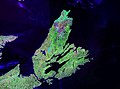 NASA landsat photo of Cape Breton Island
 -
 Cape Breton Island's second cultural flag, the "Tartan" flag (early 1990s)
 -
 Cape Breton Island's first cultural flag, the blue-and-yellow flag, dates to the 1940s.
 -
 Cape Breton Island's most recognizable and commonly used flag
 -
 Cape Breton Island's "Eagle" flag (1994)<ref>Woman wants Cape Breton flag designed by her daughter recognized – Football Archived 13 April 2014 at the Wayback Machine. Cape Breton Post (23 November 2009). Retrieved on 12 April 2014.</ref>
 -
 The former Congregation Sons of Israel synagogue, in Glace Bay. In 1902, the synagogue was Nova Scotia's first purpose-built synagogue. It permanently closed in July 2010. To the left is the also closed Talmud Torah community centre. This was the location of the Hebrew school and functions like Bar Mitzvah and wedding dinners.
 -
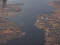
 The Sydney waterfront, focal point of the largest population centre on Cape Breton Island


.svg)
.svg)
.svg)
.svg)


See also
editNotes
editReferences
edit- ^ a b Destination Cape Breton Association Inc., Cape Breton Island. "About the Island". www.cbisland.com. Retrieved 23 September 2020.
- ^ Table from Statistics Canada – CBRM (Census Profile, 2011 Census)
- ^ Table of demonyms in Canada Archived 30 August 2014 at the Wayback Machine
- ^ a b Table from Statistics Canada (Census Profile, 2011 Census)
- ^ a b Chisholm, Hugh, ed. (1911). . Encyclopædia Britannica (11th ed.). Cambridge University Press.
- ^ a b Hamilton, William B. (1996). Place-Names of Atlantic Canada. University of Toronto Press. pp. 7–8. ISBN 0-8020-7570-3.
- ^ Everett-Heath, John (2020). "Cape Breton Island". The Concise Oxford Dictionary of World Place-Names (6 ed.). Oxford University Press. ISBN 978-0-19-190563-6.
- ^ a b Ganong, William Francis (1964). Crucial Maps in the Early Cartography and Place-Nomenclature of the Atlantic Coast of Canada. University of Toronto Press. pp. 78–81. ISBN 9781487597375.
- ^ White, J.V. (1995). A history of the native people of Canada. Hull, Quebec: Canadian Museum of Civilization. ISBN 0660159511.
- ^ "Ingonish Island". Mi'kmawey Debert Cultural Centre. Retrieved 10 August 2021.
- ^ "Peopling the Maritimes". www.ucs.mun.ca. Retrieved 10 August 2021.
- ^ "Cape Breton Island | History & Facts". Encyclopedia Britannica. Retrieved 10 August 2021.
- ^ "Cape Breton Island | The Canadian Encyclopedia". www.thecanadianencyclopedia.ca. Retrieved 10 August 2021.
- ^ de Souza, Francisco; Tratado das Ilhas Novas, 1570
- ^ Brasser, T.J. (1978). "Early Indian-European Contacts". In Trigger, Bruce G. (ed.). Handbook of North American Indians. Northeast. Vol. 15. Smithsonian Institution Press. pp. 78–88.
- ^ "Jacques Cartier". Encyclopedia Britannica. Retrieved 10 August 2021.
- ^ "The Acadians – Timeline". The Acadians. Canadian Broadcasting Corporation. 2004. Retrieved 8 August 2014.
- ^ "A Short History of Cape Breton Annexation (Part I)". The Cape Breton Spectator. 20 December 2017. Retrieved 11 August 2021.
- ^ HORNSBY, STEPHEN J. (1992). [www.jstor.org/stable/j.ctt80dck.9 Nineteenth-Century Cape Breton: A Historical Geography]. McGill-Queen's University Press. Retrieved 9 August 2021.
{{cite book}}: Check|url=value (help) - ^ a b Muiser, D.A. "Cape Breton Island". www.thecanadianencyclopedia.ca. The Canadian Encyclopedia. Retrieved 9 August 2021.
- ^ "Great Scots: The past comes to life at Highland Village Museum". The Chronicle Herald. 1 June 2014. Archived from the original on 14 June 2018. Retrieved 14 June 2018.
- ^ "History of Cape Breton Island". The Cabot Trail's Wilderness Resort on Cape Breton Island. 8 February 2010. Retrieved 14 June 2018.
- ^ Kennedy, Michael (2001). "Gaelic Report" (PDF). Nova Scotia Museum. Retrieved 13 January 2019.
- ^ "About Port Morien". Welcome to PortMorien.ca. 13 February 2010. Retrieved 9 August 2021.
- ^ a b FRANK, DAVID (1977). [www.jstor.org/stable/30302516 "The Cape Breton Coal Industry and the Rise and Fall of the British Empire Steel Corporation"]. Acadiensis. 7 (1): 3–34. ISSN 0044-5851. Retrieved 9 August 2021.
{{cite journal}}: Check|url=value (help) - ^ Frank, David (1994). [www.jstor.org/stable/25143804 "Review of Nineteenth Century Cape Breton: A Historical Geography"]. Labour / Le Travail. 33: 315–318. doi:10.2307/25143804. ISSN 0700-3862. Retrieved 9 August 2021.
{{cite journal}}: Check|url=value (help) - ^ a b c "The Nova Scotia Coal Strikes of 1922 to 1925". www.canada.ca. Canada Parks. 15 February 2016. Retrieved 6 August 2021.
- ^ a b c "Nova Scotia's Coal Industry Is in Decline. The Province Needs a Green Energy Transition". jacobinmag.com. Retrieved 14 August 2021.
- ^ Kent, Tom. "Cape Breton provides pointers for the adjustment programs required by the decline of the old economy" (PDF). School of Policy Studies. Retrieved 9 August 2021.
- ^ "Biography – DAVIS, WILLIAM – Volume XV (1921-1930) – Dictionary of Canadian Biography". www.biographi.ca. Retrieved 14 August 2021.
- ^ "Milestones:Reception of Transatlantic Radio Signals, 1901 - Engineering and Technology History Wiki". ethw.org. Retrieved 12 February 2021.
- ^ "Receiving Room of Marconi Wireless Telegraph Station, Table Head, Glace Bay, Nova Scotia". Nova Scotia Archives. Retrieved 4 April 2021.
- ^ "Economic Profile Series: Cape Breton, Nova Scotia" (PDF). Government of Canada. 2019. Retrieved 14 August 2021.
- ^ "Point Tupper Industrial Park". pointtupper.com. Retrieved 11 August 2021.
- ^ Jala, David. "Changing economy transforming Cape Breton into a place to be | Saltwire". www.saltwire.com. Retrieved 14 August 2021.
- ^ Krause, Eric R. (30 July 2014). "Fortress of Louisbourg Visitation Numbers". Krause House Info-Research Solutions. Retrieved 8 August 2014.
- ^ Ayers, Tom. "Nova Scotia extends subsidy for crumbling Cape Breton rail line". CBC. Retrieved 12 August 2021.
- ^ "Making Our Electricity". Default. Retrieved 12 August 2021.
- ^ "Nova Scotia Department of Finance - Statistics". novascotia.ca. Retrieved 11 August 2021.
- ^ Government of Canada, Statistics Canada (8 February 2017). "Census Profile, 2016 Census - Cape Breton, County [Census division], Nova Scotia and Nova Scotia [Province]". www12.statcan.gc.ca.
- ^ McEwan, Emily (2017). "Contrasting Gaelic Identities". Retrieved 13 January 2019.
- ^ a b "Welcome to Cape Breton | Education". Retrieved 11 August 2021.
- ^ Prenties, S. W. (Samuel Weller) (22 September 1782). "Narrative of a shipwreck on the island of Cape Breton, in a voyage from Quebec 1780 [microform]". London printed : [s.n.] – via Internet Archive.
- ^ Naval Chronicle. Vol. 11, p. 447
- ^ Clarke, James Stanier; Jones, Stephen; Jones, John (22 September 1805). "The Naval Chronicle". J. Gold – via Google Books.
Further reading
edit- Barlow, Maude; May, Elizabeth (2000). Frederick Street: Life and Death on Canada's Love Canal. Toronto: HarperCollins Publishers. ISBN 978-0-00-638529-5.
- Tennyson, Brian Douglas; Sarty, Roger F. (2000). Guardian of the Gulf: Sydney, Cape Breton, and the Atlantic wars. Toronto: University of Toronto Press. ISBN 0-8020-4492-1.
External links
edit| This article is prone to spam. Please monitor the References and External links sections. |