_(15507646070).jpg) | |
 | |
| Location | Bonaire, Kralendijk, Bonaire, Kralendijk, Netherlands |
|---|---|
| Coordinates | 12°08′56″N 68°16′37″W / 12.14881°N 68.27681°W |
| Tower | |
| Constructed | 1837 (first)[1] |
| Construction | stone tower[1] |
| Height | 7 metres (23 ft)[2] |
| Shape | square tapered truncated tower with balcony and light[1] |
| Markings | ochre tower |
| Power source | mains electricity |
| Light | |
| First lit | 1932 (current)[1] |
| Focal height | 13 metres (43 ft)[2] |
| Range | 5 nautical miles (9.3 km; 5.8 mi)[2] |
| Characteristic | Fl W 2s.[2] |
Kralendijk Lighthouse (or Fort Oranje Lighthouse) is an active lighthouse in the town of Kralendijk, Bonaire, in the Caribbean Netherlands. It was built in 1932 on the grounds of Fort Oranje, a 17th century fort.[3][4]
History edit
In 1639, the Dutch West India Company constructed Fort Oranje (or Oranje Battery),[5][6] which served as a military fortress until 1837. Around around 1868, a wooden lighthouse tower was built inside the walls of the fort.[4]
In 1932, a stone lighthouse was constructed in place of the wooden lighthouse.[3][4] The building and its light are still operational today.The lighthouse sits near the island's port, across from the cruise terminal. It now serves as the harbor master's office.[3][7] It is managed by the Bonaire Port Authority.
Description edit
The lighthouse is a 4-story stone pyramidal tower with a square base, with a 7 m high terrace and modern beacon.[1] The lighthouse is painted tan and the beacon is black. It emits, at a focal height of 13 m,[2] a brief white flash of 0.2 seconds per 2 second period. Its range is 5 nautical miles (approximately 9 km).[3]
Identifier : ARLHS : NEA-007 - Admiralty : J6408.3 - NGA : 110-16093 .
Light characteristic edit
Frequency : 2 seconds (W)
- Light : 0.2 seconds
- Darkness : 1.8 seconds
Gallery edit
-
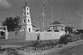 Lighthouse within the walls of Fort Oranje
 -
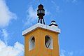 Beacon (lamp) at the top of he lighthouse
 -
 Lighthouse and fort seen from the harbor

_(15507259317).jpg)

See also edit
References edit
- ^ a b c d e "Aruba Ports Authority". Retrieved 2024-04-27.
- ^ a b c d e List of Lights, Pub. 110: Greenland, The East Coasts of North and South America (Excluding Continental U.S.A. Except the East Coast of Florida) and the West Indies (PDF). List of Lights. United States National Geospatial-Intelligence Agency. 2016. p. {{{page}}}. Cite error: The named reference "listoflights110" was defined multiple times with different content (see the help page).
- ^ a b c d Rowlett, Russ. "Lighthouses of Bonaire". The Lighthouse Directory. University of North Carolina at Chapel Hill. Retrieved 26 April 2024.
- ^ a b c "Vuurtorens op Bonaire | Beautiful Bonaire". www.beautiful-bonaire.nl (in Dutch). Retrieved 2024-04-27.
- ^ United States Hydrographic Office (1902). Navigation of the Gulf of Mexico and the Caribbean Sea. Vol. 2 (4 ed.). Washington, DC: Government Printing Office.
{{cite book}}: CS1 maint: date and year (link) - ^ Office, United States Hydrographic (1921). West Indies Pilot: The Lesser Antilles and the seacoast of Venezuela. U.S. Government Printing Office.
- ^ "Fort Orange | Kralendijk". Bon Bini Bonaire. Retrieved 2024-04-27.
External links edit
 Definitions from Wiktionary
 Media from Commons
 News from Wikinews
 Quotations from Wikiquote
 Texts from Wikisource
 Textbooks from Wikibooks
 Resources from Wikiversity