User:Abyssal/Prehistory of North America/Prehistory articles/4
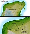
The Chicxulub crater (/ˈtʃiːkʃəluːb/; Mayan pronunciation: [tʃʼikʃuluɓ]) is a prehistoric impact crater buried underneath the Yucatán Peninsula in Mexico. Its center is located near the town of Chicxulub, after which the crater is named. The age of the Chicxulub asteroid impact and the Cretaceous–Paleogene boundary (K–Pg boundary) coincide precisely. The crater is more than 180 kilometres (110 mi) in diameter and 20 km (12 mi) in depth, making the feature one of the largest confirmed impact structures on Earth; the impacting bolide that formed the crater was at least 10 km (6 mi) in diameter. Evidence for the impact origin of the crater includes shocked quartz, a gravity anomaly, and tektites in surrounding areas.
The age of the rocks marked by the impact shows that this impact structure dates from roughly 66 million years ago, the end of the Cretaceous period, and the start of the Paleogene period. The impact associated with the crater is thus implicated in the Cretaceous–Paleogene extinction event, including the worldwide extinction of non-avian dinosaurs. This conclusion has been the source of controversy. In March 2010, 41 experts from many countries reviewed the available evidence: 20 years worth of data spanning a variety of fields. They concluded that the impact at Chicxulub triggered the mass extinctions at the K–Pg boundary. (see more...)
