![](http://upload.wikimedia.org/wikipedia/commons/thumb/4/43/Test_Template_Info-Icon_-_Version_%282%29.svg/50px-Test_Template_Info-Icon_-_Version_%282%29.svg.png)
![](http://upload.wikimedia.org/wikipedia/commons/thumb/2/2a/US_Beef_cuts.svg/400px-US_Beef_cuts.svg.png)
![](http://upload.wikimedia.org/wikipedia/commons/thumb/6/62/British_Beef_Cuts.svg/400px-British_Beef_Cuts.svg.png)
![](http://upload.wikimedia.org/wikipedia/commons/thumb/d/d5/Dutch_Beef_cuts.png/400px-Dutch_Beef_cuts.png)
![](http://upload.wikimedia.org/wikipedia/commons/thumb/9/97/Beef_cuts_Brazil.svg/400px-Beef_cuts_Brazil.svg.png)
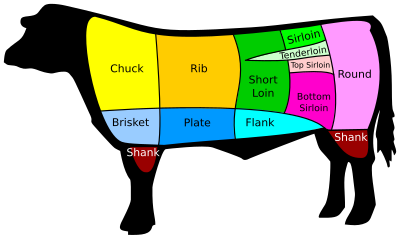
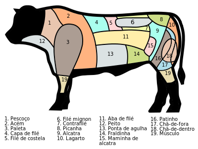
This template generates a linked image map diagram illustrating the location of various cuts of beef. Each regions of the diagram is linked to the corresponding article which describes the cut.
Usage
{{Cuts of beef diagram|type}}
Here, type
is one of the following: American
or British
or Dutch
or Brazilian
.
Optional parameters
|align=
– may be set toleft
,right
,center
, ornone
(the default isright
)|width=
– may be set to a raw number equal to the width in pixels (the default is400
)|caption=
– may be used to override the default caption.
See also
- {{Cuts of beef}}
- {{Infobox food}}