The Tapuacan River, also known as the Tapuakan River and the Pugo River, is a river located in Cares, Pugo, La Union, Philippines. Its headwaters are situated at the Santo Tomas mountain range, with the main tributary being the Najeng River located in Barangay Tabaan Norte, Tuba, Benguet.[2]
Tapuacan River
| |
|---|---|
 | |
.svg) .svg) | |
| Location | |
| Country | Philippines |
| Region | |
| Province | |
| Municipality | |
| Barangay | Cares |
| Physical characteristics | |
| Source | |
| • location | Tuba, Benguet,[1] Cordillera mountains |
| Mouth | |
• coordinates | 16°20′00″N 120°28′01″E / 16.3333°N 120.467°E |
| Basin features | |
| Tributaries | |
| • right | Najeng River[2] |
In 2017, the river was awarded by the Regional Development Council of the Ilocos Region as the cleanest and safest inland body of water in the entire region and in La Union province.[3]
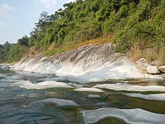
In Ilocano, tapuakan means "a place where one can jump as high". In the river, cool and pristine water flows from the town's streams amid a huge rockbeds or large (huge and quite flat) rock formations surrounded by forests and a waterfall.
Topography edit

The Pugo River is a stream (a body of running water moving to a lower level in a channel on land, class H - Hydrographic) with the region font code of Asia/Pacific.[4]
The river has crystal clear waters flowing from the mountain top towards the river mainstream, slowing down along giant stones, engulfing into the calves of other rock formations that are tact along the water's path. Its UTM position is TU20 and its Joint Operation Graphics reference is NE51-13 (with nearby cities of San Carlos City, Alaminos & Tarlac).
Tapuacan's Qiblah direction is 288.672387 degrees from North clockwise.[5] Tapuacan is part of PUGAD (which means bird's nest) or Pugo Adventure (the whole Pugo landmark site known as the newly opened Ilocos picturesque adventure and recreation destination, covering more than 3 hectares of lush mountain, forests and cleanest river).
Gallery edit
-
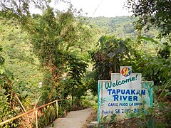 Tapuakan River welcome marker
 -
 A mini-falls
 -
 The golden sun captures the river
 -
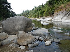 Giant rocks


See also edit
References edit
- ^ Laking, Jimmy (9 August 2009). "4 Tuba subdivisions told to abet siltation". Baguio Midland Courier. Archived from the original on 26 February 2019. Retrieved 26 February 2019.
The Pugo River is a source of irrigation to rice farmers in Pugo as well as several communities in Tuba itself where the tributaries of the river originate.
- ^ a b Alimondo, Lauren (18 July 2018). "Tuba probes waste dumping". SunStar Baguio. Archived from the original on February 26, 2019. Retrieved 26 February 2019.
... rain waters towards the creek flowing to Najeng River of Tabaan Norte which is the main contributory river of the Tapuakan River in Pugo, La Union.
- ^ "Pugo town reaps, nat'l, reg'l awards". Baguio Herald Express Online. 21 December 2017. Archived from the original on 24 December 2017. Retrieved 26 February 2019.
- ^ http://wikimapia.org/3881807/tapuakan-river [user-generated source]
- ^ "Qibla Finder, Qibla Direction, Qibla Compass & Locator | IslamicFinder".