This article is within the scope of WikiProject Slovenia, a collaborative effort to improve the coverage of Slovenia on Wikipedia. If you would like to participate, please visit the project page, where you can join the discussion and see a list of open tasks.SloveniaWikipedia:WikiProject SloveniaTemplate:WikiProject SloveniaSlovenia articles
This article is within the scope of WikiProject Italy, a collaborative effort to improve the coverage of Italy on Wikipedia. If you would like to participate, please visit the project page, where you can join the discussion and see a list of open tasks.ItalyWikipedia:WikiProject ItalyTemplate:WikiProject ItalyItaly articles
This article is within the scope of WikiProject History, a collaborative effort to improve the coverage of the subject of History on Wikipedia. If you would like to participate, please visit the project page, where you can join the discussion and see a list of open tasks.HistoryWikipedia:WikiProject HistoryTemplate:WikiProject Historyhistory articles
Latest comment: 11 years ago1 comment1 person in discussion
Great idea to create a separate page for the pre-47 period, I fully endorse that. However, I'm not very happy with the title and the concept of this new page. It just doesn't make much sense to name it this way. Why don't we transform it in a thematic page, rather than a page about an ethnic group. I would suggest either: Fascist Italianization of Littoral Slovenes; or, what would make even more sense: Fascist Italianization of the Julian March (or in the Julian March). Viator slovenicus (talk) 15:55, 24 October 2012 (UTC)Reply
Latest comment: 9 years ago13 comments3 people in discussion
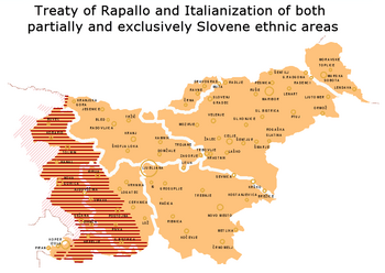
The map in the article is not exact: many of the areas marked as "partially ethnic Slovene", were in fact inhabited by an exclusively Slovene-speaking population: the Natisone and Upper Torre Valley, Resia, western Karst (including the area between Trieste and San Giovanni di Duino, which was more than 90% Slovene even according to the Italian 1921 census), the Brda (Collio) region, etc. In fact, there were very few ethnically mixed area in the northern part of the Julian March: the city of Trieste, the Muggia Hills, the immediate rural surroundings of Koper, Izola and Piran, the westernmost part of the Brda region (Dolegna del Collio), the town of Gorizia and the suburb of Podgora (all other suburbs were more than 95% Slovene, except Lucinico, which was around 85% Italian/Friulian). In Friuli, the ethnically/linguistically mixed areas were the municipalities of Prepotto, Torreana, Montenars and some villages between Cividale and San Pietro al Natisone. Here, I'm using data from the Austrian 1910 census (but also the Italian 1921 census shows pretty much the same data). Viator slovenicus (talk) 00:36, 31 October 2012 (UTC)Reply
Indeed, the exclusively Slovene-speaking areas were even larger than it is drawn on the current version of the map. The map is drawn in favour of Italians but an anonymous Italian from Brescia removed it in his edit here, calling it a "fantasy map". What on earth is he going to call it after the corrected map shows the exclusive Slovene-speaking areas under Italianization were even larger?! DancingPhilosophermy talk 18:22, 4 November 2012 (UTC)Reply
"Nova Gorica" instead of "Gorica"? Piran, Koper and Izola "Slovenian" (more than 90% Italian inhabitants in the towns, according to Austrian Census)? Last but not least: where are the Germans, here (e.g.: Maribor: more than 75% according to Austrian census)? This map is incredible fantastic!--Presbite (talk) 09:45, 10 June 2013 (UTC)Reply
Look closer before making false assertions, please, and you will see that the horizontal red hash is not extended over the towns Piran, Koper and Izola, thus this map does not claim them to be within exlcusively Slovene ethnic area. Click on the map to enlarge it and you'll see it for yourself. Also, Gorica is not within horizontal red hash, only Nova Gorica shown on the map is. Maribor being a German town makes no difference to the fact that Maribor was part of large area of Lower Styria, which however was exclusively ethnically Slovene. Again, this is a map of major areas, not of little spots within them. --DancingPhilosopher(talk) 21:18, 8 August 2013 (UTC)Reply
I'm looking closer: where are the exclusively Italian surroundings of Capodistria, Isola and Pirano, like "Cesari"? What about Tarvisio, where the majority of inhabitants was German? This map is simply a forgery.--Presbite (talk) 08:05, 18 June 2014 (UTC)Reply
Comune of Capodistria (Austrian Census, 1910): 9,340 Italians - 2,278 Slovenians
Comune of Pirano: 18,388 Italians - 4,306 Slovenians
Comune of Isola: 6,215 Italians - 2,097 Slovenians
Where are in this map the borders of this "Comuni"?--Presbite (talk) 08:48, 18 June 2014 (UTC)Reply
First, let's discuss the towns of Pirano, Isola, Capodistria and its Italian suburbs, including Cesari. They, being so small relatively to the map, can hardly be seen without using a magnifying glass, so I made an enlarged image zooming-in on those towns and it shows they are outside of the Italianization area. Capodistria, Isola and Pirano, as well as Cesari, are all outside of Italianization (horizontally red-hashed) area. Second, Canale Valley area (including Tarvisio) has been discussed by user Viator slovenicus two years ago at my Talk page discussion (that is now archived) and I asked him to use an interactive drawing tool (and shown him a tutorial how to do it) to make the correction. Sadly, nothing happened, he did not use it. So today I uploaded new version and if you have a better correction to propose, please, use this link to open the webpage with the interactive drawing tool.--DancingPhilosopher(talk) 13:03, 19 June 2014 (UTC)Reply
The map is still wrong. And you don't know where is Cesari: between Pobegi (151 Italians - 901 Slovenians in 1910) and Sv. Anton (east). Eastern side of the Comune of Capodistria. Now, in this map Cesari (100% Italians) is entirely Slovenian. Like Pobegi. What about Scoffie (580 Italians - 1042 Slovenians)? Here is only Slovenian. What about Paugnano (719 Italians in 1910)? Here is 100% Slovenian. What about the borders of the Comune of Isola? 296 Italians in the surroundings. Here 100% Slovenians. What about Corte, Parezzago, Santa Lucia and so on (in the Comune of Pirano)? Italian majority in 1910, here 100% Slovenians inhabitants.--Presbite (talk) 08:19, 20 June 2014 (UTC)Reply
The original map is here. Your map is quite different in the area of Capodistria, Isola, Pirano and surroundings.--Presbite (talk) 08:42, 20 June 2014 (UTC)Reply
Could you help me make a new version of the map so that it will accurately reflect the historic facts since the original map was claimed by Viator slovenicus (if I understood him correctly) to not being true to the facts, either. So could you two together, use Google Drawings tool that I made here (which btw lets you be anonymous, because it does not require sign-in to use it). Here is my video tutorial where you can see how to use this collaborative tool. You can choose one color and Viator may choose another one to avoid confusion. Thank you for your cooperation. --DancingPhilosopher(talk) 13:12, 20 June 2014 (UTC)Reply
The Austrian Census of 1910 is here for Trieste, Gorizia and Gradisca; here for Istria. Voilà.--Presbite (talk) 19:29, 20 June 2014 (UTC)Reply
Hello guys! I must say I didn't go through the whole discussion, but here's a suggestion: the Austrian census of 1910/1911 includes the data, for the single catastre municipalities (under the name "Ortschafte" - but in reality, it's not the villages, but rather the catastre municipalities). This clarifies things. For example, Pomjan (Paugnano) itself didn't have 720-or-so Italians, but it was the village/catastre municipality of Krkavče. Or in Izola: the breakdown along catastres lines show that indeed, the city center had a huge (almost total) Italian-speaking majority, but already the immediate surroundings (Isola-Umgebung) is more or less half-half. With these data, one can make a pretty detailed map, I think. Anyway, just a suggestion: if I mentioned something you already know, sorry. Best luck, Viator slovenicus (talk) 09:06, 30 August 2014 (UTC)Reply
Hey! Yes, I've seen the Canale Valley has been mentioned. No, indeed, I didn't have time to do it. However, again: the Austrian censuses of the region are all available online (for example in the section "Krajevni repertoriji" on the SiStory web page), so you can check out the data for every single "Ortschaft" (keep in mind, despite the name, these are in reality catastre municipalities). Best, Viator slovenicus (talk) 09:09, 30 August 2014 (UTC)Reply


