This article is within the scope of WikiProject International relations, a collaborative effort to improve the coverage of International relations on Wikipedia. If you would like to participate, please visit the project page, where you can join the discussion and see a list of open tasks.International relationsWikipedia:WikiProject International relationsTemplate:WikiProject International relationsInternational relations articles
This article is within the scope of the Military history WikiProject. If you would like to participate, please visit the project page, where you can join the project and see a list of open tasks. To use this banner, please see the full instructions.Military historyWikipedia:WikiProject Military historyTemplate:WikiProject Military historymilitary history articles
This article has been checked against the following criteria for B-class status:
According to Nuclear sharing, nuclear weapons are stationed in only one place, Büchel, not all over West-Germany... in a war, they would be put on airplanes that could fly anywhere inside or outside of Germany. The coloring should be read as Germany the national government, not a range of territory. That, and I don't have SVG vector data for the former BRD-DDR boundary. :) --JWB (talk) 08:17, 4 September 2009 (UTC)Reply
Latest comment: 13 years ago2 comments2 people in discussion
This article has a map of the "high seas." It appears to exclude not only territorial waters (which extend 12 nautical miles from the shore) but also exclusive economic zones (which extend 200 nautical miles from the shore). I think this should be changed. The "high seas" should include all international waters, i.e. everything outside territorial waters. International law gives states full jurisdiction only in their territorial waters. Their jurisdiction in the exclusive economic zone is limited to economic, not security matters. The principle of freedom of navigation in international waters means that nuclear armed vessels are permitted to travel through exclusive economic zones. The implication is that nuclear weapon free zones apply to territorial waters but not exclusive economic zones.
At least some of the NWFZs (Southeast Asian) are defined in terms of EEZs if I remember correctly.
The high seas map is a previously existing one I found on Wikipedia. I don't know if there is a world map showing 12-mile zones, but at world map scale it would look little different from an ordinary land vs. sea map anyway and have less additional value. You are welcome to look for one though.
The text could use any additional facts on international waters issues but I don't see a case for removing the map unless it is demonstrated to be irrelevant in all major POVs. --JWB (talk) 09:21, 20 July 2011 (UTC)Reply
Latest comment: 13 years ago2 comments2 people in discussion
This article uses the term "nuclear weapons state" to refer to states possessing nuclear weapons. The NPT defines a "nuclear weapon state" as one that has tested a nuclear weapon before 1967. This terminology is now fairly standard, e.g. in U.S. domestic law and in the Nuclear Suppliers Guidelines. To make this distinction clear, and to avoid granting NPT recognition to the nuclear weapon status of non-NPT parties, different terminology us usually used for the non-NPT parties, e.g. states possessing nuclear weapons. To avoid confusion I think this article should adopt that standard terminology.
Among other things, this would entail changing the map (either to make a distinction between NWS under the NPT and other states with nuclear weapons or to label them all as states possessing nuclear weapons) and revising section 5 (Non-NWS, non-NWFZ countries). NPguy (talk) 23:05, 10 July 2011 (UTC)Reply
I've revised text in response, both cutting down on unqualified use of NWS to mean nuclear weapon-possessing states, and adding explicit discussion of both NWS and territorial waters to avoid any confusion.
However I do not feel that the NPT nuclear club should always be referred to as NWS with no qualifiers, or that NWS should be considered an ambiguity-free reference to the NPT powers. The NPT article itself does not do those, and qualifies NWS at many mentions. --JWB (talk) 10:01, 20 July 2011 (UTC)Reply
Latest comment: 12 years ago5 comments2 people in discussion
The section "Countries without nuclear weapons or NWFZ" does not hold together. Even the title is awkward. What does it mean to be "without" a NWFZ? You're either inside such a zone or outside. This same awkward formulation is now repeated inside the section. I think the problem is the concept. It would be simpler just to talk about "Countries outside NWFZs." One category in that section would be countries that have (or are presumed to have - Israel) nuclear weapons.
Within the section, I think it would be clearer to organize geographically. I don't think it's correct to imply that non-NATO states in Europe are part of a nuclear umbrella. The list might look like this:
Europe (including Russia and Turkey):
3 states with NW
24 NNWS in the NATO umbrella
20 other states, including 4 EU Member States and 6 former Soviet states
Asia (and Pacific):
5 states with (or presumed to have) NW
12 Middle Eastern states
6 South Asian countries
3 major non-NATO allies of the United States (including Australia)
3 Pacific island states
North America
1 state with NW
1 NNWS in NATO
I would note that the list of Major non-NATO allies includes several states in NWFZ, several states with NW, several Middle Eastern states. I believe only two or three are considered to be under the U.S. "nuclear umbrella" (Japan and South Korea; I'm unsure about Australia). NPguy (talk) 02:28, 21 July 2011 (UTC)Reply
I think it makes sense to organize by regional (but not strictly continental) security climate influencing the likelihood of nuclear proliferation.
Europe (west of the FSU) does not have a NWFZ but does have another kind of regional security regime which prevents conflict and motivation for additional states to acquire nuclear weapons. This contrasts with the Middle East which does not have such a regional order and does have continuing military competition including suspicions of nuclear weapons development by additional states.
So even though Europe/EU/NATO has a majority of the non-NWFZ non-NWS states, those states are not proliferation risks, and can be dealt with before going on to list the states in regions where there is no such effective check against arms races. --JWB (talk) 09:11, 21 July 2011 (UTC)Reply
What about the idea of including states with and without nuclear weapons in this section? To my mind, the awkwardness came from limiting to states without nuclear weapons. If we're trying to explain the security dynamic that might drive nuclear proliferation and make NWFZs difficult, the fact that there are six countries in Asia with nuclear weapons (this time I'm including Russia in the count) has to be a relevant factor, alongside the volatile security dynamics in three sub-regions (Middle East/West Asia, South Asia, Northeast Asia). NPguy (talk) 02:28, 22 July 2011 (UTC)Reply
I will give this some thought. It would facilitate discussion of each regional situation. On the other hand, the article so far has steered clear of getting too far into that. It doesn't even have individual discussion of each NWFZ, just lists and overall statements. Mostly I want to give the reader some overall feel; they can follow links to the other articles for detail on those topics.
I am not sure it makes sense to treat Asia as a unit. Each of its subregions is as big as a continent, and on the other hand, Europe is just one peninsula of Asia. Asia has 60% of world population and 30% of area. What happens at one end has limited effect on the other. And there are two NWFZs in Central Asia, so clearly the sheer number of nuclear powers does not prevent NWFZs. --JWB (talk) 11:36, 22 July 2011 (UTC)Reply
The (renamed) section is now regionally organized, which I agree is better. I have 25 non-nuclear NATO states, while you said 24 above. --JWB (talk) 23:39, 24 February 2012 (UTC)Reply
Latest comment: 12 years ago2 comments2 people in discussion
As the article is currently written, I am unclear as to if the UN-recognized nuclear-weapon free zone prohibits ships from nuclear weapon states which carry nuclear weapons from using ports in the NWFZ. Is that allowed? (The EEZ map seems to imply that it's not, but it's never stated explicitly - at any rate it probably would be best to redraw the EEZ map to be a more explicit NWFZ map.) Is it allowed if the weapons are deactivated for the duration of the stay in port? Are there exceptions for emergencies (can a disabled ship limp into port in a NWFZ with the weapons, or does it have to dump it's nuclear weapons overboard first)? How do things work with "we can neither confirm nor deny the presence or absence of nuclear weapons aboard this ship"-type policies? (I realize that local laws may change the scope, but for the purposes of the article, I'm looking for what the UN-sanctioned NWFZ policy is.) -- 174.24.206.145 (talk) 18:40, 25 July 2011 (UTC)Reply
It is up to the individual treaties (which I have not checked) and I don't know of any effort by the UN to harmonize or change provisions beyond what each region's countries chose in the treaties. AFAIK the 5 NWFZ treaties for inhabited areas were initiatives of the countries and their regional organization, not of the UN. --JWB (talk) 23:50, 24 February 2012 (UTC)Reply
The text of the article describes various latitudes and longitude-based boundaries which scope the land areas eligible for various NWFZs. It would be helpful to have these mapped in addition to the excellent existing map of which countries have which status (land areas only). This could help reduce some twisty prose. -- Beland (talk) 10:04, 8 December 2014 (UTC)Reply
Could you say more about what we are trying to convey? I'm open to the idea of a map with lines through oceans, but that tends to give the impression the zones are effective on the ocean itself, and the map projection does not have lines of longitude as straight lines, so those would have to be supplied as curves.
The zones wind up including all Southern Hemisphere land except the box between the Equator and 60°S, and between 20°W and 115°E, so I made a map of that box specifically and included it. --JWB (talk) 19:12, 14 August 2015 (UTC)Reply
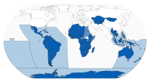
Hi, I made this map of the NWFZ boundaries - do we think this would be appropriate? It's programatically generated so I'm happy to take notes. World map showing major nuclear weapon free zones and their areas of application. --Courier New (talk) 12:21, 15 March 2024 (UTC)Reply
I see a couple of problems with the map. For Africa, it leaves out one country (South Sudan) even though there are quite a few countries that haven't ratified. It also covers a lot of ocean, which is a bit misleading. The zone may cover territories within the shaded parts of the ocean, it doesn't cover the ocean per se. Nuclear-armed submarines can deploy in those areas. There is a similar map at the UN website, though it has the same problem with the oceans. NPguy (talk) 16:42, 16 March 2024 (UTC)Reply
I agree about the African countries who have signed but not ratified - happy to make those a lighter shade. My understanding re: South Sudan is that it didn't exist when the treaty was signed and hasn't taken a formal position on it, so I left it out.[1][2] Re: The ocean, looks like you're right regarding the Rarotonga treaty [3], but the Tlatelolco treaty seems to say explicitely that it does cover the ocean in addition to territory.[4] - is there a secondary source that clears this up? Otherwise it seems prudent to follow the UNODA map you linked to. Courier New (talk) 18:42, 16 March 2024 (UTC)Reply
I'm not sure what to make of the "zone of application" of the Treaty of Tlatelolco as described in article 4.2. It seems to imply that there's some obligation that applies to those areas of the open ocean, but it also seems that the core obligations of the Contracting Parties are limited to their national territories. Maybe it is meant to say that any state -- current or future -- within the zone as defined in 4.2 may become a party to the treaty. There is, for example, the provision in Article 28.4 for a new power arising in the zone.
As for South Sudan, the best way to think about it is as a successor to Sudan. I don't know the details of treaty law, but one way for states to join treaties is as successors. You can see in the UN list of parties to the NPT, for example, you'll find states that joined by ratification, by accession, and by succession. NPguy (talk) 21:16, 20 March 2024 (UTC)Reply
Latest comment: 7 years ago3 comments3 people in discussion
This article appears to contradict another article. Please discuss at the talk page and do not remove this message until the contradictions are resolved.
The treaty makes the zone effective on all signers after 28 countries had ratified, which was reached in mid-2009.
The map does predate the Sudan split and the file does not have coordinates for the Sudan-South Sudan boundary. However it is unlikely that South Sudan will denounce the zone. --JWB (talk) 18:51, 14 August 2015 (UTC)Reply
I agree that the map is misleading. It implies that all countries in Africa are parties to a NWFZ treaty. In fact, quite a few are not. This is not a South Sudan issue. Perhaps there should be a different color for countries that are geographically within a zone but not parties to the NWFZ treaty. NPguy (talk) 02:43, 14 September 2016 (UTC)Reply
Latest comment: 6 years ago3 comments2 people in discussion
The lead section of the article says that the definition of an NWFZ "does not count countries or smaller regions that have outlawed nuclear weapons simply by their own law". The cited source for the definition is from 1975. However, the infobox at the top of the article appears to include Mongolia as one of the listed NWFZs. Also, a 1974 UNGA resolution (3261 F) reportedly said that "obligations relating to the establishment of nuclear-weapon-free zones may be assumed not only by groups of states, including entire continents or large geographical regions, but also by small groups of States and even individual countries" (although I am having trouble finding that language in that resolution), and Mongolia appears to have some form of UN recognition status (which was achieved decades after the 1975 definition was established). Also, the second section of the article says there is "one UN-recognized zone consisting of a single country, Mongolia". When I tried to adjust the lead section to account for the existence of this described "one UN-recognized zone", my change was reverted. How should Mongolia be considered in the lead section and the infobox? Is the description of the status of Mongolia in the second section accurate? Should Mongolia be removed from the NWFZ list in the infobox? Do the (unsourced) population count and population percentage that are provided for "All NWFZs combined" in the infobox include Mongolia? —BarrelProof (talk) 18:00, 19 September 2017 (UTC)Reply
Mongolia is not a nuclear-weapon-free zone, in part because such zones are treaties among states of a region. It is not recognized as a zone by the UN, but there have been UN General Assembly resolutions recognizing its nuclear-weapon-free status. The article should not list Mongolia as a party to a zone or show it on a map as a member of a zone, but it would be OK to keep the current graphic and change the caption to make clear that Mongolia is different. NPguy (talk) 02:57, 20 September 2017 (UTC)Reply


