Talk:New York State Route 24/Archive 1
| This is an archive of past discussions. Do not edit the contents of this page. If you wish to start a new discussion or revive an old one, please do so on the current talk page. |
| Archive 1 |
Evidence of proposed NY 24 & Suffolk CR 101 overpass
"Other proposed extensions built by Suffolk County were Suffolk Avenue(SCR 100), Furrows Road, Peconic Avenue, and the formerly proposed Central Suffolk Highway(SCR 90)[3]. The right-of-way for the Central Suffolk Highway can be found beneath the Suffolk CR 101 bridge over the Main Line of the Long Island Rail Road.[citation needed]" ---Well, since I can't get a photograph of this bridge unless I take a trip back up to Long Island and take one, here's a Wikimap of the bridge in question(http://wikimapia.org/#y=40821722&x=-72941623&z=18&l=0&m=h&v=2). ---- DanTD 00:43, 21 June 2007 (UTC)
External links modified (February 2018)
Hello fellow Wikipedians,
I have just modified one external link on New York State Route 24. Please take a moment to review my edit. If you have any questions, or need the bot to ignore the links, or the page altogether, please visit this simple FaQ for additional information. I made the following changes:
- Added archive https://web.archive.org/web/20100421073203/http://www.nycroads.com/roads/suffolk_076-100/ to http://www.nycroads.com/roads/suffolk_076-100/
When you have finished reviewing my changes, you may follow the instructions on the template below to fix any issues with the URLs.
This message was posted before February 2018. After February 2018, "External links modified" talk page sections are no longer generated or monitored by InternetArchiveBot. No special action is required regarding these talk page notices, other than regular verification using the archive tool instructions below. Editors have permission to delete these "External links modified" talk page sections if they want to de-clutter talk pages, but see the RfC before doing mass systematic removals. This message is updated dynamically through the template {{source check}} (last update: 5 June 2024).
- If you have discovered URLs which were erroneously considered dead by the bot, you can report them with this tool.
- If you found an error with any archives or the URLs themselves, you can fix them with this tool.
Cheers.—InternetArchiveBot (Report bug) 14:48, 17 February 2018 (UTC)
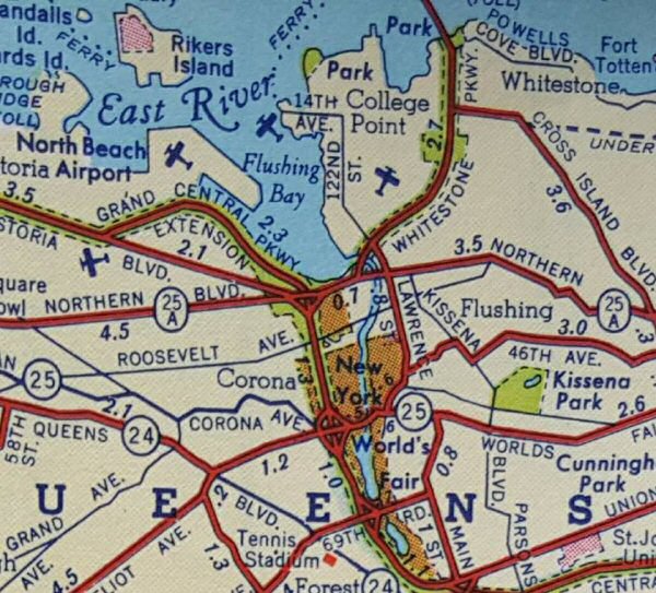
NY 24 on Queens Boulevard
I just found a map of the 1939 World's Fair indicating that NY 24 was the exclusive designation for Queens Boulevard back in the day when it went west of Queens Village. ---------User:DanTD (talk) 13:02, 28 December 2018 (UTC)
NY 24, Long Island Avenue, and the missing link to Hampton Bays
This 1931 Pan-Am Oil Map Published by H.M. Gousha shows the original connection between NY 110 and Former NY 113. Essentially it was to follow Long Island Avenue (including parts of Pine Aire Drive, Suffolk Avenue, Johnson Avenue, and Union Avenue) east to Sills Road in Yaphank, then run in a straight east line until it reaches South Manor, curving around some hills before intersecting with East Moriches-Riverhead Road (including Lake Avenue), then follows that route until finally connecting to the current eastern NY 24 at the Riverside Traffic Circle. ---------User:DanTD (talk) 17:32, 22 December 2019 (UTC)
Decommissioned?
In Riverhead at the traffic circle driving north on 24 there is a sign that says "end 24." The remainder is only signed County Route 94 now, and has been for a couple years now.
I don't know if that segment (from the circle to I-495) has actually been decommissioned, or just is now unsigned.